At a Glance - icrisat
At a Glance - icrisat
At a Glance - icrisat

You also want an ePaper? Increase the reach of your titles
YUMPU automatically turns print PDFs into web optimized ePapers that Google loves.
I. Introduction<br />
To provide the most efficient way to understand<br />
the farming systems in rural areas, and to identify<br />
the socioeconomic constraints faced by the farming<br />
community in the semi-arid tropics (SAT), the then<br />
Economics Program of the International Crops Research<br />
Institute for the Semi-Arid Tropics (ICRISAT) initiated<br />
Village Level Studies (VLS) in 1975 at six villages in SAT<br />
India. Solapur district in Maharashtra state is one of the<br />
regions covered under the VLS, from which two villages,<br />
namely, Kalman and Shirapur belonging to North Solapur<br />
and Mohol taluks, respectively, were selected.<br />
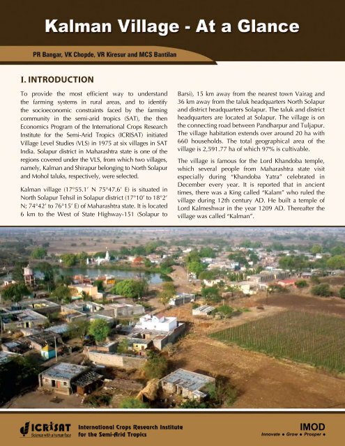
Kalman village (17°55.1’ N 75°47.6’ E) is situated in<br />
North Solapur Tehsil in Solapur district (17°10’ to 18°2’<br />
N; 74°42’ to 76°15’ E) of Maharashtra state. It is located<br />
6 km to the West of State Highway-151 (Solapur to<br />
Barsi), 15 km away from the nearest town Vairag and<br />
36 km away from the taluk headquarters North Solapur<br />
and district headquarters Solapur. The taluk and district<br />
headquarters are located at Solapur. The village is on<br />
the connecting road between Pandharpur and Tuljapur.<br />
The village habitation extends over around 20 ha with<br />
660 households. The total geographical area of the<br />
village is 2,591.77 ha of which 97% is cultivable.<br />
The village is famous for the Lord Khandoba temple,<br />
which several people from Maharashtra state visit<br />
especially during “Khandoba Yatra” celebrated in<br />
December every year. It is reported that in ancient<br />
times, there was a King called “Kalam” who ruled the<br />
village during 12th century AD. He built a temple of<br />
Lord Kalmeshwar in the year 1209 AD. Thereafter the<br />
village was called “Kalman”.<br />
IMOD<br />
Innovate Grow Prosper
The village falls within the semi-arid tropics with a<br />
normal annual rainfall of 550 mm which is, however,<br />
erratic in nature. The village has evolved over decades<br />
in terms of agricultural advancement and economic<br />
development. Poverty still haunts the village. Kalman<br />
has good infrastructure. It is well connected by roads<br />
to important cities and towns. A railway station exists<br />
20 km away from the village. Main roads in the village<br />
are cemented. Nearly 85% of the households have<br />
access to electricity. About 60% of the households<br />
have pucca/semi-pucca houses. Nearly 40% of the<br />
households access safe drinking water through tap<br />
connections while the remaining households meet their<br />
water requirement through 4 electric motor-operated<br />
borewells, 5 hand pumps and 3 public taps connected<br />
to 3 water tanks.<br />
II. HISTORICAL BACKGROUND/<br />
DEVELOPMENT OF THE VILLAGE<br />
During the last three decades, Kalman village has<br />
progressed, in varying degrees, in terms of social, political,<br />
economic, technological, institutional, infrastructural,<br />
educational and religious advancement.<br />
Social: About four decades ago, people in the village<br />
lived isolated based on caste groups. In other words, the<br />
houses were segregated by major caste groups; the socalled<br />
forward caste people lived in the middle of the<br />
village while the backward caste people lived on the<br />
periphery. Presently, the situation has changed – they<br />
live together; the houses of the forward and backward<br />
castes are interspersed. Due to population growth, the<br />
villagers have purchased private residential plots or<br />
occupied gram panchayat land, constructed houses and<br />
are living together.<br />
The households in the village belong to 22 castes.<br />
As of 2010, the Maratha caste is the dominant caste<br />
in the village, accounting for 224 of the 660 resident<br />
2<br />
households (34 percent), followed by Dhangar (14<br />
percent), Mali (13 percent), Mahar or Navboudha (9<br />
percent), Koshti (6 percent), Wani (5 percent), Muslim<br />
(4 percent), Chambhar (4 percent), Sutar and Wadar<br />
(2 percent each). Though the caste-wise composition<br />
of households during the mid-1970s was almost the<br />
same as compared to the present, the number of Mali<br />
caste households has significantly increased from 38<br />
to 86 accounting for 126 percent growth, whereas the<br />
Dhangar, Mahar/Navboudha and Maratha castes grew<br />
at 84 percent, 66 percent and 63 percent, respectively.<br />
Another important element of social transformation<br />
is the sourcing of drinking water. As of now, every<br />
household draws drinking water from the same water<br />
source unlike the earlier practice of dedicated wells for<br />
the households of scheduled castes/tribes owing to the<br />
practice of “untouchability”.<br />
Political: In 1970s, the village was ruled by people of<br />
the Maratha caste with the support of people of other<br />
castes. However, over time, through several legislations,<br />
the government has provided opportunities for people of<br />
different caste groups and also for women. This has led<br />
to political empowerment of weaker sections, namely,<br />
backward castes and women.<br />
There is a Gram Panchayat in the village with eleven<br />
members. These panchayat members are elected<br />
by the villagers every five years. The present Gram<br />
Panchayat is headed by a woman from forward caste<br />
(Maratha). This gram panchayat is hosted in the “Mini-<br />
Assembly” building that was constructed in 2001. In<br />
this village, one Agricultural Assistant/Gram Sevak<br />
is attached to the village panchayat and he works as<br />
Secretary to the gram panchayat and also as extension<br />
official of Block Development Office.<br />
There are two strong politically rival groups in the<br />
village that are affiliated to the national/regional<br />
political parties. During election periods, hectic<br />
political activity and tension are visible in the village.<br />
Kalman Village - <strong>At</strong> a <strong>Glance</strong>
Economic: The village witnessed economic development<br />
due to increase in livelihood options including salaried<br />
jobs, petty business, out-migration for labor earnings,<br />
small-scale industries, etc. The main driver of this<br />
economic development is agricultural development. In<br />
1970s, villagers predominantly depended on agriculture<br />
for their livelihood and very few had salaried jobs.<br />
Farmers were following traditional agricultural practices.<br />
Some large farmers and money lenders in the village<br />
provided loans to small peasants at exorbitant interest<br />
rates. Of late, farmers have started adopting improved<br />
agricultural technologies including machinery. This<br />
resulted in increased farm-credit needs of farmers.<br />
Presently, sufficient institutional credit facilities are<br />
available in the village, which cater to the farmers’ credit<br />
needs at reasonable interest rates. The government also<br />
supports them with several subsidies on, for example,<br />
credit (waive-off), interest on borrowing, purchase of<br />
machinery, etc. The number of salaried people has<br />
increased over time.<br />
the village that supply improved seeds, fertilizers and<br />
pesticides. Farmers also use sprinkler and drip irrigation<br />
to increase the efficiency of available limited water.<br />
There are more than 45 sprinkler sets and 30 drip sets<br />
in the village. Use of tractor is common for threshing<br />
grains, land preparation and transportation of farm<br />
produce. There are a total of 11 tractors and 7 threshers<br />
in the village. Threshers are being used for threshing<br />
wheat, sorghum, mungbean, pigeonpea, chickpea, etc.<br />
An agriculture extension service center was opened in<br />
2006. Presently, there are 16 computers in the village.<br />
Almost every household in the village has mobile phone<br />
connectivity, which is one of the important media<br />
available to access agricultural information.<br />
Technological: The agricultural development has taken<br />
place through technological advancement in terms<br />
of adoption of improved varieties, access to inputs<br />
and machinery at village level, increased irrigation<br />
facility through sprinkler and drip, and crop/farm<br />
diversification.<br />
Institutional: Institutionally, the village has developed<br />
over time. Presently, there is a post office, BSNL telephone<br />
office, veterinary hospital, Primary Health Centre, Bank<br />
of Maharashtra and District Central Cooperative bank,<br />
four educational institutions and two fair price shops in<br />
the village.<br />
The village has a branch of District Central Cooperative<br />
(DCC) Bank established in 1985 as well as that of Bank of<br />
Maharashtra established in 1983. It also has a registered<br />
Primary Agricultural Credit Society (PACS), which is<br />
functioning satisfactorily since its establishment in<br />
More than 50% of the farmers now use improved/hybrid<br />
seeds, chemical fertilizers, weedicides and fungicides<br />
to increase farm productivity and enhance their net<br />
incomes. More than 90 percent farmers are using<br />
Maldandi variety of sorghum. In case of pigeonpea,<br />
farmers have adopted improved and hybrid pigeonpea<br />
cultivars like ICPL 87119 and ICPH 2671.<br />
The use of chemical fertilizers and pesticides has<br />
increased, while the farm yard manure (FYM) usage<br />
has declined. There are two agriculture input shops in<br />
Kalman Village - <strong>At</strong> a <strong>Glance</strong> 3
1957. This PACS is attached to the DCC Bank, Kalman<br />
branch. The village has three private milk dairies.<br />
A Primary Health Centre (PHC) was established in<br />
the village in the year 1985. Since then, it has been<br />
providing novel health care service to the villagers in<br />
terms of family planning, immunization, vaccination,<br />
food for pregnant women and newly born babies, etc.<br />
These services of PHC are implemented by an Auxiliary<br />
Nurse and Midwife (ANM). In addition, a Multi-Purpose<br />
Worker (MPW) supported by the Gram Panchayat is<br />
attached to PHC for facilitating these activities. Besides,<br />
there are five private doctors providing necessary<br />
medical care to the villagers on payment basis. There is<br />
one private medical store in the village.<br />
Infrastructural: The infrastructure in the village has<br />
grown tremendously over time. The village was<br />
electrified in 1967 for providing electricity for domestic<br />
and commercial purposes. Electricity is used for running<br />
flour mills, lifting water for irrigation, and for domestic<br />
purposes. Street lights are provided by the panchayat on<br />
all the village roads. About 85% of the houses have been<br />
electrified. The villagers were provided tap connections<br />
for drinking water supply in 1983. The village has an<br />
approach road to the city. The village has access to<br />
the State Road Transport Corporation Bus service, with<br />
buses passing through the village about 5 times a day. In<br />
addition, private jeeps and minibuses are also available<br />
in the village. There is a weekly market on Saturday in<br />
the village, which was started way back in the 1960s.<br />
The other infrastructure facilities available in the village<br />
include cement roads, mini-assembly, medical stores,<br />
agricultural inputs and machinery shops and flour mills,<br />
among others.<br />
increased household incomes. The literacy rate amongst<br />
males is 89 percent while that of females is 81 percent,<br />
the overall being 86.5 percent (2001 Census).<br />
In Kalman, the exact date of establishment of the school<br />
is not known but facilities were available for voluntary<br />
education since 1870. As of now, the education facility<br />
available in the village is up to Standard 12. There are<br />
four Anganwadis and one each of Primary School (started<br />
in 1962), Secondary School (1962), Higher Secondary<br />
School (1966) and Junior College (up to Standard 12)<br />
(2007). The present enrolment (2010-11) in all the<br />
aforesaid schools put together is 928 (474 males and<br />
454 females). There are two “Gram Shikshana Samithis”<br />
(Village Education Committees) in the village started<br />
in 1995; one for the primary school and the other for<br />
secondary and higher secondary schools together. The<br />
high schools and higher secondary schools are run by<br />
Education Societies, whereas the primary school is run<br />
by Zilla Parishad, Solapur under the supervision of these<br />
“Gram Shikshana Samithis”.<br />
Religious: One old temple of Lord Khandoba was built in<br />
1664, and another temple dates back to the 13 th century.<br />
There are nine temples and one mosque in the village in<br />
addition to three bhajan mandals.<br />
Educational: Literacy and educational status of the<br />
villagers has improved significantly due to provision<br />
of higher education facility in the village coupled with<br />
4<br />
Kalman Village - <strong>At</strong> a <strong>Glance</strong>
III. BASIC STATISTICS OF THE VILLAGE<br />
A) LOCATION / ACCESSIBILITY<br />
1. Village: Kalman 2. Taluka: North Solapur 3. District: Solapur<br />
4. State: Maharashtra 5. PIN: 413222<br />
6. GPS values: (a) Latitude: 17°55.1’ N (b) Longitude: 75°47.6’ E (c) Altitude (m): 491<br />
7. Nearest town: (a) Name: Vairag (b) Distance from village (km): 15<br />
8. Nearest State Highway: (a) Number: SH 151 (b) Distance from village (km): 6<br />
9. Nearest National Highway: (a) Number: NH 9 (b) Distance from village (km): 35<br />
10. Name of the Village Panchayat in which the village falls: Kalman<br />
11. Details of the Sarpanch/Village Panchayat President:<br />
(a) Name: Ms Shobhabai Bhujing Lambe (b) Cell No.: 08975446663<br />
12. Details of the Gram Sevak/Agricultural Assistant:<br />
(a) Name: Mr Nitin Bhimashankar Chaudhari (b) Cell No.: 09850130089<br />
B) DEMOGRAPHY (as on 1 September 2007)<br />
1. Population (No): 3,344 2. Households (No): 660 3. Voters (No): 2,837 4. Farmer accounts/Khatas (No): 691<br />
5. Classification of population:<br />
Category No. Farm Size* No. Religion No. Caste No. Literacy No. Gender No.<br />
SC 304 Landless 644 Hindu 3193 Maratha 1118 Illiterates (
6. Classification of households:<br />
Male headed (No.): 644 Female headed (No.): 16<br />
Category No. Farm Size* No. Caste No. Religion No. Main occupation No.<br />
SC 58 Landless 160 Maratha 224 Hindu 632 Farming 261<br />
ST 29 Marginal 96 Shepherd 90 Muslim 28 Agril.labor 160<br />
OBC 281 Small 169 Mali 86 Non-agril.labor 72<br />
General 292 Medium 146 Navboudha 58 Caste occupation 25<br />
Large 89 Koshti 40 Others$ 142<br />
Wani 33<br />
Muslim 28<br />
Cobbler 26<br />
Carpenter 17<br />
Wadar 15<br />
Barber 9<br />
Potter 8<br />
Washerman 6<br />
Brahmin 5<br />
Koli 4<br />
Berad 3<br />
Jangam 3<br />
Gosavi 1<br />
Swami 1<br />
Blacksmith 1<br />
Sonar 1<br />
Teli 1<br />
Total 660 660 660 660 660<br />
$ include salaried, money lenders, middlemen, service sector, etc. * As defined in B(5) overleaf.<br />
C) LAND USE PATTERN (2009-10)<br />
1. Distribution of Geographical Area: Ha 2. Cropped Area Acres<br />
Agricultural land 2,511 Kharif 3,113<br />
Permanent fallow 17 Rabi 2,835<br />
Grazing lands 21 Summer 180<br />
Land used for roads, buildings & non-agril. purposes 19 Annual/Perennial crops 62<br />
Gawthan (used for Government housing schemes) 17 Gross Cropped Area 6,190<br />
Current fallow 7 3. Irrigated Area Acres<br />
Kharif 310<br />
Rabi 950<br />
Summer 180<br />
Annual/Perennial crops 62<br />
Total Geographical Area 2,592 Gross Irrigated Area 1,502<br />
D) LAND RESOURCES<br />
1. Soil distribution 2. Irrigation sources (as on 31 December 2010)<br />
Soil type % area Sources Total No. Working No. Approx. depth (ft) of<br />
working wells<br />
Irrigable area<br />
(Ac/year)<br />
Deep black 7 Borewells 190 165 340 600<br />
Medium black 23 Open wells 315 300 58 902<br />
Shallow black 47 Approx. land area<br />
Loam soil 8<br />
covered (ac)<br />
Murrum 13 Ponds 3 0 0.4 0<br />
Problematic 2 Tanks 3 0 2.1 0<br />
3. Rainfall: (a) Quantity (mm/year): Normal: 550 Actual (Jun’09-May’10): 637<br />
(b) No. of rainy days: Normal: 30 Actual (Jun’09-May’10): 45<br />
6 Kalman Village - <strong>At</strong> a <strong>Glance</strong>
E) CROP PRODUCTION (2009-10)<br />
Kharif Rabi Summer Annual/Perennial Crops<br />
Crops Area(ac) Crops Area(ac) Crops Area(ac) Crops Area(ac)<br />
Pigeonpea 2,050 Sorghum 2,155 Groundnut 50 Grape 33<br />
Maize 212 Chickpea 138 Fodder 25 Citrus 12<br />
Sunflower 175 Maize 112 Vegetables 88 Banana 12<br />
Groundnut 75 Wheat 102 Others 17 Coconut 3<br />
Vegetables 300 Sunflower 88 Pomegranate 1<br />
Other pulses 150 Vegetables 152 Guava 1<br />
Others 151 Others 88<br />
Total 3,113 Total 2,835 Total 180 Total 62<br />
F) ASSETS (as on 1 June 2010)<br />
1. Productive Assets: 2. Consumer Assets: 3. Buildings:<br />
Livestock Heavy machinery Type No. Type No.<br />
Type No. Type No. Television 223 Houses-Pucca 570<br />
Cow (indigenous) 106 Tractor 11 Refrigerator 24 Houses-Kuchcha 90<br />
Cow (exotic) 190 Thresher 7 Air-Conditioner 2 Cattle sheds 196<br />
Buffalo 155 Bullock Cart 61 Washing machine 4 Irrigation pump houses 245<br />
Bullock 270 Auto 1 LPG connection 165 Storage godowns 2<br />
Sheep 97 Van 9 Dish Antenna 9<br />
Goat 387 Jeep 4 Motorbike/Scooty 182<br />
Poultry 624 Tum-Tum 11 Car/Jeep 4<br />
Flour mill 8 Computer 16<br />
Milk sale (lt/day) 560 CGM# 3<br />
Others 11<br />
#Chilli Grinding Machine.<br />
G) BASIC NEEDS (as on 31 December 2010)<br />
1. Type of food (# of households): (a) Vegetarian: 214 (b) Non-vegetarian: 446<br />
2. Type of clothes: (a) Men: Pant-Shirt, Dhoti-Shirt (b) Women: Sari and blouse<br />
3. Type of houses: (a) Pucca: 570 (b) Kuchcha: 90<br />
H) INFRASTRUCTURE (as on 31 December 2010)<br />
1. Village electrification: Yes No. of houses having access to electricity: 582<br />
2. Is there a Tar/metal/cement road to village? Yes<br />
3. Is there a tar/metal/cement road inside the village? Yes Length of the road (m): 425<br />
4. Public transport facility:<br />
Public/private bus facility to village available?: Yes No.of trips/day from town to village: 3<br />
Other modes of travel available? Yes Available modes: Auto, Jeep, Tum Tum<br />
5. Drinking water facility: Yes Source(s): Open well/Bore well<br />
Tap connections available? Yes No. of connections: 268<br />
6. Public toilet/urinal facility: Yes No. of toilets: 5<br />
7. Public health facility: Yes No. of PHC: 1 Private Doctors: 4<br />
8. Veterinary health facility: Yes<br />
9. Banking facility: Yes No. of PACS: 1 Commercial Bank: 1 Pvt. Bank: 1<br />
10. Educational facilities:<br />
Level Number of institutions Enrolment (number)<br />
Male<br />
Female<br />
Pre-primary (Anganwadi) 4 101 99<br />
Primary (1-4 years) 1 123 123<br />
Secondary (5-7 years) 1 116 99<br />
Higher Secondary (8-10 years) 1 129 102<br />
College (11-12 years) 1 5 31<br />
Kalman Village - <strong>At</strong> a <strong>Glance</strong><br />
7
11. Agricultural input shops:<br />
Input Available in village? If no, nearest available place Distance from village (km)<br />
Seed<br />
Yes<br />
Fertilizer<br />
Yes<br />
Pesticide<br />
Yes<br />
Machinery – Purchase No Solapur, Barshi 40 km each<br />
Machinery – Custom hiring<br />
Yes<br />
12. Agricultural output market:<br />
Weekly shandy in the village? Yes Which day? Saturday<br />
No. of wholesale traders/commission agents in the/visiting the village: 5<br />
13. Storage godowns/warehouses: Yes Total capacity of all (tons): 10<br />
14. Other business units (number):<br />
Grocery shop: 18 PDS Shop: 2 Kerosene shop: 1<br />
Hotel/Canteen: 4 Flour Mill: 8 Chilli/spices grinding shop: 5<br />
Meat shop: 2 Liquor shop: 4 Pan shop: 7<br />
Carpenter: 5 Blacksmith: 1 Goldsmith: 2 (Weekly)<br />
Cobbler: 2 Potter: 2 Mason: 25<br />
TV/Radio mechanic: 7 Cycle repair shop: 4 Motorcycle repair shop: 3<br />
Money lenders: 5<br />
15. Other institutions (number):<br />
SHG/Sakhi Mandal: 25 Milk Dairies: 3 Post Office: 1<br />
Dispute Resolution Committee: 1 Youth Club: 1 Bhajan Mandal: 3<br />
Drama Mandal: 3 Chit Fund: 7 Community Hall: 1<br />
Mini Assembly: 1<br />
16. Place of worship (No): Temple: 9 Mosque: 1<br />
I) GOVERNMENT WELFARE PROGRAMS / POLICIES (as on 31 December 2010)<br />
1. Government programs recently implemented/ongoing and beneficiaries:<br />
SN Name of the Government Program Beneficiaries (No. of households)<br />
1 Public Distribution System 660 (Ration Cards – 947)<br />
2 Old Age Pension 70<br />
3 Widow Pension 5<br />
4 Indira Awas Yojana 14<br />
5 Family Planning 15<br />
6 Self Help Groups 277<br />
7 Subsidies on Farm Well (BPL households) 2<br />
About ICRISAT<br />
The International Crops Research Institute for the Semi-Arid Tropics (ICRISAT) is a non-profit, non-political organization that conducts agricultural research for<br />
development in Asia and sub-Saharan Africa with a wide array of partners throughout the world. Covering 6.5 million square kilometers of land in 55 countries,<br />
the semi-arid tropics have over 2 billion people, and 644 million of these are the poorest of the poor. ICRISAT and its partners help empower these poor people to<br />
overcome poverty, hunger, malnutrition and a degraded environment through better and more resilient agriculture.<br />
ICRISAT is headquartered in Hyderabad, Andhra Pradesh, India, with two regional hubs and four country offices in sub-Saharan Africa. It belongs to the Consortium<br />
of Centers supported by the Consultative Group on International Agricultural Research (CGIAR).<br />
ICRISAT-Patancheru<br />
Patancheru 502 324, Andhra Pradesh, India<br />
Tel +91 40 30713071 Fax +91 40 30713074<br />
<strong>icrisat</strong>@cgiar.org<br />
www.<strong>icrisat</strong>.org<br />
Citation: Bangar PR, Chopde VK, Kiresur VR and Bantilan MCS. 2011. Kalman Village - <strong>At</strong> a <strong>Glance</strong>.<br />
Patancheru 502 324, Andhra Pradesh, India: International Crops Research Institute for the Semi-Arid Tropics.