Geophysical Institute of the ASCR
Geophysical Institute of the ASCR
Geophysical Institute of the ASCR

Create successful ePaper yourself
Turn your PDF publications into a flip-book with our unique Google optimized e-Paper software.
0<br />
-10 -5 0 5 10 15 20<br />
2<br />
200<br />
Udryn<br />
depth, m<br />
400<br />
600<br />
end <strong>of</strong><br />
<strong>the</strong> last<br />
ice age<br />
13.7<br />
6<br />
Sidorowka<br />
13.7 for<br />
higher heat<br />
flow<br />
800<br />
9.5<br />
13<br />
15<br />
1000<br />
T L - 1.7 °C<br />
T L<br />
1200<br />
-10 -5 0 5 10 15 20<br />
temperature, °C<br />
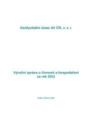
Fig. 2. Temperature-depth pr<strong>of</strong>iles measured in boreholes Udryn and Sidorowka in <strong>the</strong> temperature anomaly<br />
region and a numerical simulation <strong>of</strong> <strong>the</strong>ir time changes. The initial temperature–depth pr<strong>of</strong>ile at <strong>the</strong> end <strong>of</strong> <strong>the</strong><br />
last ice age (a start <strong>of</strong> <strong>the</strong> simulation, time 0) is in an equilibrium with a surface ground temperature <strong>of</strong> -10.3°C<br />
and a deep heat flow <strong>of</strong> 40 mW.m -2 . The right-hand side pr<strong>of</strong>ile corresponds to <strong>the</strong> higher heat flow <strong>of</strong> 50 mW.m -2<br />
outside <strong>the</strong> anomalous region. Curves T L -1.7°C and T L delineate a depth-dependent interval <strong>of</strong> <strong>the</strong> thawing<br />
temperature <strong>of</strong> <strong>the</strong> underground ice. Curve labels are in thousands <strong>of</strong> years since <strong>the</strong> beginning <strong>of</strong> <strong>the</strong> simulation.<br />
References<br />
Šafanda J., Szewczyk J. and Majorowicz J., 2004. Geo<strong>the</strong>rmal evidence <strong>of</strong> very low glacial temperatures on a rim <strong>of</strong> <strong>the</strong><br />
Fennoscandian ice sheet. Geophys.Res.Lett., 31, L07211, doi:10.1029/2004 GL019547.<br />
Recent subsurface temperature changes in <strong>the</strong> Czech Republic,<br />
Portugal and Slovenia and <strong>the</strong>ir coupling to air temperatures<br />
Climatic interpretation <strong>of</strong> <strong>the</strong> ground surface temperature history obtained from present-day<br />
temperature-depth pr<strong>of</strong>iles measured in deep boreholes is based on an assumed long-term tracking <strong>of</strong><br />
<strong>the</strong> mean annual surface air temperature and <strong>the</strong> ground surface temperature. To explore this<br />
assumption, we have started a project on a long-term monitoring <strong>of</strong> <strong>the</strong> coupling between air and soil<br />
temperatures in three different climatic provinces <strong>of</strong> Europe, namely in <strong>the</strong> Czech Republic, Slovenia<br />
and Portugal. The “borehole climate” stations have been established and <strong>the</strong> monitoring launched at<br />
three Czech sites, namely at Prague-Spořilov (in 1993), at <strong>the</strong> meteorological station Kocelovice<br />
(1998) and near town Potůčky (Krušné Hory Mountains, in <strong>the</strong> year 2002), at Slovenian Kostanjevica<br />
(2003) (Fig. 3) and at Portuguese Évora (2005). The observatories monitor air (2 m and 5 cm height),<br />
soil (2, 5, 10, 20, 50 and 100 cm depth) and bedrock temperatures (down to <strong>the</strong> depth <strong>of</strong> 40 m) at<br />
a sampling rate <strong>of</strong> 30 minutes with <strong>the</strong> aim to provide data on <strong>the</strong> air-ground temperature coupling<br />
and on a propagation <strong>of</strong> seasonal, interannual and secular surface temperature changes into <strong>the</strong><br />
bedrock. The monitoring is expected to continue for several years to map <strong>the</strong> tracking <strong>of</strong> <strong>the</strong> air and<br />
ground mean annual temperatures on an interannual time scale.<br />
17