Geophysical Institute of the ASCR
Geophysical Institute of the ASCR
Geophysical Institute of the ASCR

Create successful ePaper yourself
Turn your PDF publications into a flip-book with our unique Google optimized e-Paper software.
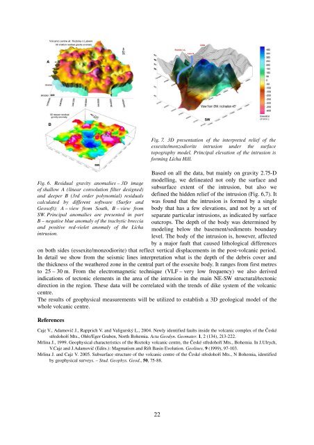
Fig. 6. Residual gravity anomalies – 3D image<br />
<strong>of</strong> shallow A (linear convolution filter designed)<br />
and deeper B (3rd order polynomial) residuals<br />
calculated by different s<strong>of</strong>tware (Surfer and<br />
Geos<strong>of</strong>t); A – view from South, B – view from<br />
SW. Principal anomalies are presented in part<br />
B – negative blue anomaly <strong>of</strong> <strong>the</strong> trachytic breccia<br />
and positive red-violet anomaly <strong>of</strong> <strong>the</strong> Lícha<br />
intrusion.<br />
Based on all <strong>the</strong> data, but mainly on gravity 2.75-D<br />
modelling, we delineated not only <strong>the</strong> surface and<br />
subsurface extent <strong>of</strong> <strong>the</strong> intrusion, but also we<br />
defined <strong>the</strong> hidden relief <strong>of</strong> <strong>the</strong> intrusion (Fig. 6,7). It<br />
was found that <strong>the</strong> intrusion is formed by a single<br />
body that has a few elevations, and not by a set <strong>of</strong><br />
separate particular intrusions, as indicated by surface<br />
outcrops. The depth <strong>of</strong> <strong>the</strong> body was determined by<br />
modeling below <strong>the</strong> basement/sediments boundary<br />
level. The body <strong>of</strong> <strong>the</strong> intrusion is, however, affected<br />
by a major fault that caused lithological differences<br />
on both sides (essexite/monzodiorite) that reflect vertical displacements in <strong>the</strong> post-volcanic period.<br />
In detail we show from <strong>the</strong> seismic lines interpretation what is <strong>the</strong> depth <strong>of</strong> <strong>the</strong> debris cover and<br />
<strong>the</strong> thickness <strong>of</strong> <strong>the</strong> wea<strong>the</strong>red zone in <strong>the</strong> central part <strong>of</strong> <strong>the</strong> essexite body. It ranges from first metres<br />
to 25 – 30 m. From <strong>the</strong> electromagnetic technique (VLF – very low frequency) we also derived<br />
indications <strong>of</strong> tectonic elements in <strong>the</strong> area <strong>of</strong> <strong>the</strong> intrusion in <strong>the</strong> main NE-SW structural/tectonic<br />
direction in <strong>the</strong> region. These data will be correlated with <strong>the</strong> trends <strong>of</strong> dike system <strong>of</strong> <strong>the</strong> volcanic<br />
centre.<br />
The results <strong>of</strong> geophysical measurements will be utilized to establish a 3D geological model <strong>of</strong> <strong>the</strong><br />
whole volcanic centre.<br />
References<br />
Fig. 7. 3D presentation <strong>of</strong> <strong>the</strong> interpreted relief <strong>of</strong> <strong>the</strong><br />
essexite/monzodiorite intrusion under <strong>the</strong> surface<br />
topography model. Principal elevation <strong>of</strong> <strong>the</strong> intrusion is<br />
forming Lícha Hill.<br />
Cajz V., Adamovič J., Rapprich V. and Valigurský L., 2004. Newly identified faults inside <strong>the</strong> volcanic complex <strong>of</strong> <strong>the</strong> České<br />
středohoří Mts., Ohře/Eger Graben, North Bohemia. Acta Geodyn. Geomater. 1, 2 (134), 213-222.<br />
Mrlina J., 1999. <strong>Geophysical</strong> characteristics <strong>of</strong> <strong>the</strong> Roztoky volcanic centre, <strong>the</strong> České středohoří Mts., Bohemia. In J.Ulrych,<br />
V.Cajz and J.Adamovič (Edits.): Magmatism and Rift Basin Evolution. Geolines, 9 (1999), 97-103.<br />
Mrlina J. and Cajz V. 2005. Subsurface structure <strong>of</strong> <strong>the</strong> volcanic centre <strong>of</strong> <strong>the</strong> České středohoří Mts., N Bohemia, identified<br />
by geophysical surveys. – Stud. Geophys. Geod., 50, 75-88.<br />
22