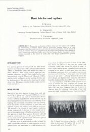
160-165 - International Glaciological Society
160-165 - International Glaciological Society
160-165 - International Glaciological Society

You also want an ePaper? Increase the reach of your titles
YUMPU automatically turns print PDFs into web optimized ePapers that Google loves.
Annals 0/ Glaciology 9 1987<br />
@ <strong>International</strong> <strong>Glaciological</strong> <strong>Society</strong><br />
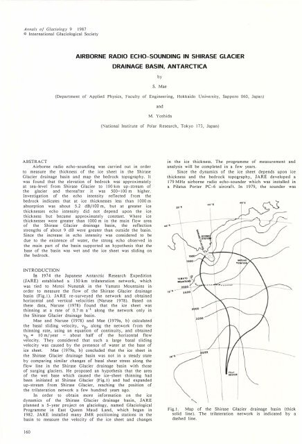
AIRBORNE RADIO ECHO-SOUNDING IN SHIRASE GLACIER<br />
DRAINAGE BASIN. ANTARCTICA<br />
by<br />
S. Mae<br />
(Department of Applied Physics, Faculty of Engineering, Hokkaido University, Sapporo 060, Japan)<br />
and<br />
M. Yoshida<br />
(National Institute of Polar Research, Tokyo 173, Japan)<br />
ABSTRACT<br />
Airborne radio echo-sounding was carried out in order<br />
to measure the thickness of the ice sheet in the Shirase<br />
Glacier drainage basin and map the bedrock topography. It<br />
was found that the elevation of bedrock was approximately<br />
at sea-level from Shirase Glacier to lOO km up-stream of<br />
the glacier and thereafter it was 500- 100 m higher.<br />
Investigation of the echo intensity reflected from the<br />
bedrock indicates that at ice thicknesses less than 1000 m<br />
absorption was about 5.2 dB/lOO m, but at greater ice<br />
thicknesses echo intensity did not depend upon the ice<br />
thickness but became approximately constant. Where ice<br />
thicknesses were greater than 1000 m in the main flow area<br />
of the Shirase Glacier drainage basin, the reflection<br />
strengths of about 9 dB were greater than outside the basin.<br />
Since the increase in echo intensity was considered to be<br />
due to the existence of water, the strong echo observed in<br />
the main part of the basin supported an hypothesis that the<br />
base of the basin was wet and the ice sheet was sliding on<br />
the bedrock.<br />
in the ice thickness. The programme of measurement and<br />
analysis will be completed in a few years.<br />
Since the dynamics of the ice sheet depends upon ice<br />
thickness and the bedrock topography, JARE developed a<br />
179 MHz airborne radio echo-sounder which was installed in<br />
a Pilatus Porter PC-6 aircraft. In 1979, the sounder was<br />
INTRODUCTION<br />
In 1974 the Japanese Antarctic Research Expedition<br />
(JARE) established a 150 km trilateration network, which<br />
was tied to Motoi Nunatak in the Yamato Mountains in<br />
order to measure the flow of the Shirase Glacier drainage<br />
basin (Fig.I). JARE re-surveyed the network and obtained<br />
horizontal and vertical velocities (Naruse 1978). Based on<br />
these data, Naruse (1978) found that the ice sheet was<br />
thinning at a rate of 0.7 m a-1 along the network only in<br />
the Shirase Glacier drainage basin.<br />
Mae and Naruse (1978) and Mae (1979a, b) calculated<br />
the basal sliding velocity, V b ' along the network from the<br />
thinning rate, using an equation of continuity, and obtained<br />
V b<br />
= 10 m/year - about half of the horizontal flow<br />
velocity. They considered that such a large basal sliding<br />
velocity was caused by the presence of water at the base of<br />
ice sheet. Mae (1979a, b) concluded that the ice sheet in<br />
the Shirase Glacier drainage basin was not in a steady state<br />
by comparing similar changes of basal shear stress along the<br />
flow line in the Shirase Glacier drainage basin with those<br />
of surging glaciers. He proposed an hypothesis that the area<br />
of the wet base which caused the ice-sheet thinning had<br />
been initiated at Shirase Glacier (Fig. I ) and had expanded<br />
up-stream from Shirase Glacier, reaching the position of<br />
the trilateration network a few hundred years ago.<br />
In order to obtain more information on the ice<br />
dynamics of the Shirase Glacier drainage basin, JARE<br />
planned a 5-year project on glaciology, named <strong>Glaciological</strong><br />
Programme in East Queen Maud Land, which began in<br />
1982. JARE installed many JMR positioning stations in the<br />
basin to measure the velocity of the ice sheet and changes<br />
Fig. I. Map of the Shirase Glacier drainage basin (thick<br />
solid line). The trilateration network is indicated by a<br />
dashed line.<br />
<strong>160</strong>
Mae and Yoshida: Airborne radio echo-sounding in Shirase Glacier<br />
used to make a preliminary sounding of Shirase Glacier and<br />
the Yamato Mountains. At that time the aircraft possessed<br />
poor naviagational instruments and the position of the<br />
aircraft was determined only by map reading. The<br />
sounding flight passed over as many known sites (e.g.<br />
nunataks or exposed rocks) as possible. On the basis of<br />
these data. Wada and others (1982) made a<br />
bedrock-topography map in the vicinity of the Yamato<br />
Mountains, but it proved impossible to map the bedrock<br />
elevations near Shirase Glacier due to poor navigation. In<br />
1983, JARE carried out further airborne radio<br />
echo-sounding using an Omega navigation system. A<br />
preliminary report of the sounding was published by Mae<br />
(1986), and in this paper the results obtained will be<br />
reported in detail.<br />
TABLE I. SPECIFICATIONS OF SOUNDER<br />
Transmitter<br />
Carrier frequency<br />
Pulse width<br />
Rise time<br />
Peak power<br />
Pulse-repetition frequency<br />
Total power consumption<br />
RF gain<br />
Receiver<br />
Central frequency<br />
Band width<br />
Noise<br />
Receiver sensitivity<br />
179 MHz<br />
0.3 j1S<br />
0.15 j1S<br />
IkW<br />
1kHz<br />
dc 28V,2.7 A<br />
39 dB<br />
179 MHz<br />
5 kHz<br />
3 dB<br />
-104 dBm<br />
INSTRUMENTS AND SOUNDING AREA<br />
Since the 179 MHz sounder was designed to be installed<br />
in the small (Pilatus Porter PC-6) aircraft, electric power<br />
and aerial dimensions were limited. The peak transmitter<br />
power was restricted to about I kW and aerials, I m in<br />
length, were attached to the wings of the aircraft. These<br />
limited the depth of penetration to 1500-2000 m. The details<br />
of the sounder have been reported by Wada and Mae (I 981)<br />
and Wada and others (1982), and its specifications are listed<br />
in Table I. The previous recording system of A-scopes was<br />
changed from a 35 mm camera to a video set.<br />
The radio echo-sounding was carried out in November<br />
1983 along the routes shown in Fig.2. Flight lines 4, 5, 6,<br />
and 7 are in the Shirase Glacier drainage basin.<br />
The up-stream area of the Shirase Glacier drainage<br />
basin was not surveyed because of logistics difficulties in<br />
supporting the aircraft. At present, only oversnow vehicles<br />
can survey this up-stream area. In this paper, therefore,<br />
only the results of the radio echo-sounding along the routes<br />
shown in Fig.2 are discussed.<br />
Aerials<br />
Monitor and<br />
recorder<br />
3-element Vagi<br />
Absolute<br />
power gain<br />
Oscilloscope (National VP-5260)<br />
Rise time: 35 ns<br />
Video set<br />
8 dB<br />
RESULTS<br />
Bedrock topography<br />
In order to estimate ice thickness, the wave velocity in<br />
ice of 169 m jLS-l (Robin and others 1969) was used.<br />
Surface-elevation data for the Mizuho Plateau area,<br />
including the Shirase Glacier drainage basin, were compiled<br />
by Moriwaki of the Japanese National Institute of Polar<br />
Research and the bedrock topography was obtained by<br />
subtraction of the ice thicknesses.<br />
50 km<br />
--<br />
'- '-<br />
•<br />
'Mizuho St.<br />
, , , ,<br />
,<br />
,<br />
,<br />
"<br />
)<br />
Fig.2.<br />
Radio echo-sounding flight lines (thick solid lines).<br />
161
Mae and Yoshida: Airborne radio echo-sounding in Shirase Glacier<br />
2000<br />
(m)<br />
1-A<br />
1-0<br />
Fig.3a. Bedrock topography (thick lines) and surface topography (thin line) of flight I. b. Bedrock<br />
topography (thick lines) and surface topography (thin line) of flight 5.<br />
The elevation of the ice surface and the bedrock along<br />
flights 1 and 5 are shown in Fig.3a and b. The<br />
elevations of the bedrock surface are at sea-level or higher.<br />
On the basis of these results, a contour map of bedrock<br />
elevation was compiled and this is shown in Fig.4.<br />
Fig.3a and Fig.4 indicate that there are subglacial<br />
mountains at the up-stream edge of flights 1 and 2 which<br />
are about 2000 m above sea-level. The presence of the<br />
mountains had been previously assumed from areas of bareice<br />
field with many crevasses and containing rock debris. In<br />
the Shirase Glacier drainage basin there are not such high<br />
subg\acial mountains. From Fig.4 it can be seen that a<br />
shallow and wide valley lies between Shirase Glacier and<br />
Mizuho Station. Even in this basin, the elevation of the<br />
bedrock on the upstream side of the sounding area is about<br />
500 m above sea-level. This is consistent with the result<br />
obtained from a 60 MHz radio echo-sounding survey of an<br />
oversnow traverse from Mizuho Station to the Yamato<br />
mountains (Shimizu and others 1978; Nishio, private<br />
communication). It can be assumed that the bedrock<br />
elevation is 500-1000 m above sea-level in the up-stream<br />
area of the Shirase Glacier drainage basin (personal<br />
communication from M. Yoshida).<br />
Echos reflected from bedrock<br />
The intensity, E, of the reflected echo from the<br />
bedrock surface varies with ice thickness. As shown in<br />
Fig.5a and b, E decreases in proportion to the increase of<br />
ice thickness, h, up to 1000 m, thereafter E is approximately<br />
constant.<br />
When h is less than 1000 m, E (in dB) along flight<br />
is given by<br />
E = -o.0052h - 26.<br />
(I)<br />
and E along flight 5 is given by<br />
E = -o.0052h - 25.<br />
(2)<br />
Since Equations (I) and (2) are approximately the same, the<br />
characteristic feature of the reflection from bedrock shows<br />
little difference between the Shirase Glacier drainage basin<br />
and the surrounding area. If the reflection coefficient at the<br />
bedrock surface is uniform, the absorption within the ice<br />
mass is estimated to be 5.2 dB/lOO m. This value is larger<br />
than 4.5 dB/lOO m obtained by Robin and others (1969) in<br />
Greenland.<br />
At ice thicknesses greater than 1000 m, E does not<br />
depend on h and becomes approximately constant. The value<br />
of E in the Shirase Glacier drainage basin, (= -78 dB) is<br />
larger than in the surrounding area (= -87 dB). It is<br />
difficult to explain the difference, 9 dB. It is not clear, if<br />
water exists at a base, where there are high hydrostatic<br />
pressures of about 15-20 MPa and how such water may<br />
influence the dielectric properties of ice at radio<br />
frequencies.<br />
The spatial distribution of E is illustrated in Fig.6. In<br />
the Shirase Glacier drainage basin E at A and C is smaller<br />
162
Mae alld Yoshida.· Airbo me radio<br />
echo-sou n d' mg in Sh' lrase Gl aCler .<br />
YAM ATO<br />
MOUNTAINS<br />
Fig.4. Map of bedrock topograph y.<br />
co<br />
"C<br />
•<br />
•<br />
-40<br />
•<br />
• •<br />
•<br />
• •<br />
•<br />
•<br />
•<br />
•<br />
• •<br />
•<br />
• • •<br />
••<br />
•<br />
•<br />
•<br />
•<br />
•<br />
• • •<br />
• •<br />
w<br />
-70<br />
. , .<br />
•<br />
•<br />
•<br />
• •<br />
•<br />
•<br />
• •<br />
•<br />
• •<br />
•<br />
• • e ••<br />
e.<br />
•<br />
•<br />
,<br />
• •<br />
• •<br />
•<br />
•<br />
• ••<br />
•<br />
•<br />
w<br />
-70<br />
• • 0<br />
•<br />
•<br />
• •<br />
•<br />
•<br />
•<br />
•<br />
• •<br />
• •<br />
•<br />
• • e •<br />
• ... .<br />
• •<br />
.A<br />
•<br />
•<br />
• •<br />
• •<br />
•<br />
• • •<br />
:<br />
• •<br />
•<br />
• • • •<br />
..<br />
•<br />
• •<br />
• •<br />
-100<br />
500<br />
h<br />
1000----' 1500<br />
(m)<br />
-100<br />
Fig.Sa. R elationship between E and h, flight I. b. RI e atlOnship ' between E and h, flight 5.<br />
500<br />
h<br />
1000<br />
1500<br />
(m)<br />
163
Mae and Yoshida: Airborne radio echo-sounding in Shirase Glacier<br />
than E in the neighbouring area. At A in Fig.6 there is a<br />
mountain at A in Fig.4 and at C in Fig.6 there is a ridge<br />
from C' to Coo in Fig.4. Down-stream of A and C in<br />
Fig.6 there are areas, D and F, with high E. However, in<br />
the down-stream area, B', in Fig.6 of the highest mountain<br />
B in Fig.4, E is low as shown in Fig.6 and there is no<br />
high E area such as D and F.<br />
In Fig.6 there is a area of low E values, G, in the<br />
main flow area in the Shirase Glacier drainage basin.<br />
DISCUSSION<br />
The reflection of radio-echo energy may be affected<br />
by the properties of the bedrock and the roughness of the<br />
bedrock surface. It is impossible, however, to investigate<br />
these factors under a thick ice sheet. When h is less than<br />
1000 m, the relationship between E and h is given by<br />
approximately the same equation as in the sounding area.<br />
Yoshida and others (I987) have found that echo<br />
intensity depends upon the angle between the direction of<br />
the ice flow and the aerial orientation. When they are<br />
parallel, the echo intensity is strong. In this survey, the<br />
direction of the aerials is the same as the direction of the<br />
aircraft long axis, which varied with wind direction and<br />
wind velocity during flight. It is conceivable, therefore, that<br />
the influence of the aerial direction is negligibly small in<br />
this survey.<br />
If the properties<br />
roughness are uniform,<br />
of<br />
a<br />
the bedrock and its<br />
possible explanation<br />
surface<br />
of the<br />
differences in E is that the echo strength in the Shirase<br />
Glacier drainage basin is affected by the presence of water<br />
at the base. Outside of the basin, ice is frozen to the<br />
bedrock.<br />
At A in Fig.4 there is a subglacial mountain with an<br />
ice thickness of about 1200 m. The average temperature at<br />
the ice surface at this point is about -30 ° C, given that the<br />
average temperature gradient with elevation is -1 .3 ° C/100 m<br />
at Mizuho Plateau (Satow 1978). The flow velocity has not<br />
been measured but is estimated to be 30 m a-l. The<br />
accumulation rate is 100-200 mm a- l . Based on these data,<br />
temperature calculations carried out by Nishio and Mae<br />
(1979), the basal temperature is about _10 0 - _15 0 C, and<br />
matches with the low value of E.<br />
Since the flow velocity along the ridge from C' to Coo<br />
is less than the velocity of the main flow area of the<br />
Shirase Glacier drainage basin (Naruse 1978), it is<br />
reasonable to suppose that the basal sliding velocity is zero<br />
and the basal ice is frozen to the bedrock.<br />
E is also low around the mountain B and in the<br />
down-stream area of B. Although E becomes higher in the<br />
down-stream area of low B in the Shirase Glacier drainage<br />
basin, there is no high area such as D and F in Fig.6 in<br />
the down -stream area of B. This suggests the basal ice is<br />
frozen to bedrock.<br />
As shown in Fig.6, a wide, curved valley extends from<br />
Shirase Glacier towards Mizuho Station, where the elevation<br />
of the bedrock is approximately 150 m above sea-level.<br />
Elsewhere in the sounded area the bedrock elevation is<br />
I<br />
I<br />
I<br />
I<br />
,<br />
, '<br />
: <br />
I<br />
I<br />
f<br />
I<br />
--.<br />
f<br />
,<br />
,<br />
,<br />
,<br />
,<br />
2000<br />
'.<br />
f<br />
f<br />
I<br />
,<br />
;,.$"-<br />
, _.<br />
,<br />
,<br />
,<br />
,<br />
f<br />
,<br />
,<br />
,<br />
f<br />
I<br />
I'<br />
. '.<br />
/<br />
/<br />
2000<br />
... _-----<br />
.' • " • _' ___ 2400<br />
,<br />
,<br />
,<br />
Fig.6. Map of the bedrock reflection coefficient. x, -40 dB > E > --60 dB; ., --60 dB > E > -70 dB;<br />
!:1, -70 dB > E > -80 dB; ., E < -80 dB.<br />
164
Mae and Yoshida: Airborne radio echo-sounding in Shirase Glacier<br />
about 500 m above sea-level. According to radio echosounding<br />
conducted on oversnow traverses (National Institute<br />
of Polar Research 1985; Yoshida and others 1987), a high<br />
plateau (500- 1000 m) extends further inland.<br />
Mae (1979a, b) and Mae and Naruse (1978) proposed<br />
that the basal ice is wet along the trilateration network in<br />
the Shirase Glacier drainage basin (Fig. I ) and such a wet<br />
base is related to basal sliding of about 10 m a-I and an<br />
ice-sheet thinning rate of 700 m a-I. Mae (I979a, b) and<br />
Mae (I982) suggested that the area of wet basal ice<br />
(approximately the same area as the region of ice-sheet<br />
thinning) expanded in size a few hundred years ago. This<br />
idea of disequilibrium is supported by the profile of basal<br />
shear stress, T b ' along the flow line in the Shirase Glacier<br />
drainage basin which displays characteristics similar to those<br />
of surging glaciers (Mae 1979a, b; Mae 1982). Mae (1979a,<br />
b) estimated that T b<br />
reached a maximum of about 180 kPa<br />
in the region between the boundary of this sounding area<br />
and the trilateration network.<br />
If such an hypothesis is correct, the ice-sheet thinning<br />
must take place in the down-stream area of the Shirase<br />
Glacier drainage basin. Although no direct proof of this<br />
hypothesis is available, it is reasonable to consider that the<br />
wet basal zone expanded from Shirase Glacier to the<br />
relatively low area of bedrock surface which is surrounded<br />
by the 500 m high plateau. At present, the mechanism of<br />
formation of the wet base and its expansion is not clear,<br />
but it is important for understanding the historical<br />
variations of the ice sheet in this area.<br />
The low values of the reflection coefficient at G in<br />
the Shirase Glacier drainage basin are difficult to explain as<br />
the bedrock surface is only about 100 m higher than the<br />
surrounding area; this is insufficient evidence to suggest<br />
that the base is frozen to the bedrock.<br />
Wada M, Yamanouchi T, Mae S 1982 Radio echo-sounding<br />
of Shirase Glacier and the Yamato Mountains area.<br />
Annals 0/ Glaciology 3: 312-315<br />
Yoshida M, Yamashita K, Mae S 1987 Bottom topography<br />
and internal layers in east Dronning Maud Land, East<br />
Antarctica, from 179 MHz radio echo-sounding. Annals 0/<br />
Glaciology 9: 221-224<br />
ACKNOWLEDGEMENT<br />
This study is partly supported by a Grant-in-Aid to<br />
Scientific Research of the Ministry of Education, Science<br />
and Culture, Japan. This is a contribution to the<br />
<strong>Glaciological</strong> Research Programme in east Queen Maud<br />
Land, Antarctica, by JARE.<br />
REFERENCES<br />
Mae S 1979[a] The basal sliding of a thinning ice sheet,<br />
Mizuho Plateau, East Antarctica. Journal 0/ Glaciology<br />
24(90): 53-6 1<br />
Mae S 1979[b] The recent variation of ice sheet in Mizuho<br />
Plateau. Memoirs 0/ National Institute 0/ Polar Research.<br />
Special Issue 14: 1-7<br />
Mae S 1982 Hyo-Sho no dorikigaku [Dynamics of ice<br />
sheet]. In Kori to yuki [Ice and snow]. Tokyo,<br />
National Institute of Polar Research: 117-163<br />
Mae S 1986 Radio echo sounding in the Shirase Glacier<br />
drainage basin. Antarctic Record 30(1): 11-18<br />
Mae S, Naruse R 1978 Possible causes of ice sheet thinning<br />
in the Mizuho Plateau. Nature 273(5660): 291-292<br />
Naruse R 1978 Surface flow and strain of the ice sheet<br />
measured by a triangulation chain in Mizuho Plateau.<br />
Memoirs 0/ National Institute 0/ Polar Research. Special<br />
Issue 7: 198-226<br />
National Institute of Polar Research 1985 Data 0/ Antarctic<br />
research. Tokyo, National Institute of Polar Research<br />
Nishio F, Mae S 1979 Temperature profile in the bare ice<br />
area near the Yamato Mountains, Antarctica. Memoirs 0/<br />
National Institute 0/ Polar Research. Special Issue 12:<br />
25-37<br />
Robin G de Q, Evans S, Bailey J T 1969 Interpretation of<br />
radio echo sounding in polar ice sheets. Geophysical<br />
Transactions 0/ the Royal <strong>Society</strong> 0/ London Ser A<br />
265(1166): 437-505<br />
Satow K 1978 Distribution of 10 m snow temperatures in<br />
Mizuho Plateau. Memoirs 0/ National Institute 0/ Polar<br />
Research. Special Issue 7: 63-71<br />
Wada M, Mae S 1981 Airborne radio echo sounding on the<br />
Shirase Glacier and its drainage basin, East Antarctica.<br />
Antarctic Record 72: 16-25<br />
<strong>165</strong>