

Ore Bin / Oregon Geology magazine / journal - Oregon Department ...
Ore Bin / Oregon Geology magazine / journal - Oregon Department ...
Ore Bin / Oregon Geology magazine / journal - Oregon Department ...

You also want an ePaper? Increase the reach of your titles
YUMPU automatically turns print PDFs into web optimized ePapers that Google loves.
OREGON GEOLOGY<br />
published by the<br />
<strong>Ore</strong>gon <strong>Department</strong> of <strong>Geology</strong> and Mineral Industries<br />
VOLUME 51, NUMBER 6 NOVEMBER 1989
OREGON GEOLOGY<br />
(ISSN 0164-3304)<br />
VOLUME 51, NUMBER 6 NOVEMBER 1989<br />
Published bimonthly in January, March, May. July. September. and November by the <strong>Ore</strong>gon <strong>Department</strong><br />
of <strong>Geology</strong> and Mineral Industries. (Volumes I through 40 were entitled The <strong>Ore</strong> <strong>Bin</strong>.)<br />
Governing Board<br />
Sidney R. Johnson, Chair<br />
Rooald K. Culbertson<br />
Donald A. Haagensen .<br />
State Geologist<br />
Deputy State Geologist<br />
Publications Manager/Editor<br />
Associate Editor . . . . .<br />
.... Baker<br />
Myrtle Creek<br />
... Portland<br />
Donald A. Hull<br />
. John D. Beaulieu<br />
. Beverly F. Vogt<br />
. Klaus K.E. Neuendorf<br />
Main Office: 910 State Office Building, 1400 SW Fifth Ave., Portland<br />
97201, phone. (503) 229-5580.<br />
Baker Field Office: 1831 First Street, Baker 97814, phone (503) 523-<br />
3133. Howard C. Brooks, Resident Geologist<br />
Grants Pm8 Field Office: 5375 Monument Drive, Grants Pass 9752fJ,<br />
phone (503) 476-2496. Thomas J. Wiley, Resident Geologist.<br />
Mined Land Reclarnation Program: 1534 Queen Ave. SE, Albany<br />
97321, phone (503) 967-2039. Gary W Lynch, SupeIVisor.<br />
Second class postage paid at Portland, <strong>Ore</strong>gon. Subscription rates: I<br />
year, $6; 3 years, $15. Single issues, $2. Available back issues of <strong>Ore</strong><br />
<strong>Bin</strong>/<strong>Ore</strong>gon <strong>Geology</strong> Ihrough v. 50, no. 4, $1. Address subscription orders,<br />
renewals, and changes of address to <strong>Ore</strong>gon <strong>Geology</strong>, 910 State Office<br />
Building, 1400 SW 5th Ave., Portland, OR 97201. Pennission is granted<br />
to reprint infonnation contained herein. Credit given to the <strong>Ore</strong>gon <strong>Department</strong><br />
of <strong>Geology</strong> and Mineral Industries for compiling this infonnation<br />
will be appreciated. POSTMASTER: Send address changes to <strong>Ore</strong>gon<br />
<strong>Geology</strong>, 910 State Office Building, 1400 SW 5th Ave., Portland, OR<br />
97201.<br />
Information for contributors<br />
<strong>Ore</strong>gon<strong>Geology</strong>isdesignedtoreachawidespectrumofreadersinterested<br />
in the geology and mineral industry of <strong>Ore</strong>gon. Manuscript contributions<br />
are invited on both teclmical and general-interest subjects relating to <strong>Ore</strong>gon<br />
geology. Two copies of the manuscript should be submitted, typed double-spaced<br />
throughout (including references) and on one side of the paper<br />
only. If manuscript was prepared on common word-processing equipment,<br />
a file copy on 5-in. diskette may be submitted in addition to the paper<br />
copies. Graphic illustrations should be camera-ready; photographs should<br />
be black-and-white glossies. All figures should be clearly marl
Industrial minerals in <strong>Ore</strong>gon<br />
by Ronald P. Geitgey, <strong>Ore</strong>gon <strong>Department</strong> of <strong>Geology</strong> and Mineral Industries<br />
ABSTRACT<br />
A wide variety of industrial minerals is produced<br />
in <strong>Ore</strong>gon for regional, national, and<br />
international markets. The estimated total value<br />
of nonfuel mineral production in <strong>Ore</strong>gon in<br />
1988 was $169 million, virtually all of which<br />
was from industrial minerals. Sand, gravel, and<br />
crushed rock accounted for approximately $115<br />
million.<br />
Limestone is quarried from one location for<br />
cement production and sugar-beet processing<br />
and from two other locations for agricultural<br />
uses. Diatomite is produced by two companies,<br />
one for filter aids and the other for pet litter<br />
and oil absorbents. Bentonite clay from two<br />
operations is used primarily for civil-engineering<br />
applications, and structural clays are used<br />
by two brick manufacturers. Pumice from two<br />
areas is sold to concrete-block producers, and<br />
lesser· amounts are used for landscaping and<br />
for stone-washing certain garments. The zeolite<br />
mineral clinoptilolite is processed for absorbents<br />
and odor-control products. Exploration<br />
and limited production of perlite continues, and<br />
emery is produced for nonskid surface coatings.<br />
Quartzofeldspathic beach dunes supply material<br />
for container glass production, and quartz<br />
is quarried for nickel smelting, filter beds, poultry<br />
grit, and decorative uses. Talc, in the form<br />
of soapstone, has an international market as<br />
fine-quality art-carving material, and gemstone<br />
production includes agates, opal, obsidian, and<br />
suns tone, a calcic plagioclase feldspar.<br />
Many commodities produced in the past in<br />
<strong>Ore</strong>gon merit reevaluation. Some of these are<br />
brick clays, chromite, expandable shales,<br />
foundry sands, gypsum, iron-oxide pigments,<br />
peat, and building stone, including gray granites,<br />
white marble, black marble, sandstones,<br />
and volcanic tuffs. Production ceased for most<br />
of these because of market conditions and increased<br />
costs rather than product quality or deposit<br />
reserves.<br />
Several other commodities have the potential<br />
for new or increased production. Some have<br />
been evaluated; others are known occurrences<br />
that have geologic potential for commercial development.<br />
They include bentonite clay, borates,<br />
feldspar, ferruginous bauxite, fuller's<br />
earth, kaolin clay, nepheline syenite, perlite,<br />
and talc.<br />
INTRODUCTION<br />
Industrial, or nonmetallic, minerals are often<br />
unnoticed commodities, but their production<br />
is essential to nearly all phases of a modern<br />
economy, including construction, manufacturing,<br />
and production of food, fuels, and fibers.<br />
Their total value far exceeds that of the metals<br />
in both national and world markets.<br />
The term "industrial minerals" defies succinct,<br />
comprehensive definition. It encompasses<br />
natural rocks and minerals as well as<br />
manufactured products such as cement and<br />
lime. While often tern1ed "nonmetals", some<br />
industrial minerals are, in fact, metal ores that<br />
are utilized for properties other than their contained<br />
metal. Bauxite, for example, is the ore<br />
of aluminum metal but also the basis for some<br />
refractories (heat-resistant materials), abrasives,<br />
chemicals, and pharmaceuticals. Similarly,<br />
gemstones such as diamond and sapphire<br />
are included in some discussions of industrial<br />
minerals, in part because of their role as abrasives<br />
in the form of industrial diamonds and<br />
corundum. Perhaps it is simpler to say that<br />
industrial minerals are naturally occurring rocks<br />
and minerals and certain products manufactured<br />
from them that are not used as metal ores or<br />
as fuels.<br />
The uses of industrial minerals are highly<br />
diverse. Some are dependent on physical properties<br />
such as strength, hardness, softness, color,<br />
and density, while other uses, including chemicals,<br />
fertilizers, ceramics, and glass, are dependent<br />
on chemical composition. Hard or<br />
tough minerals such as quartz, gamet, or emery<br />
are used as abrasives and on wear-resistant surfaces.<br />
Soft minerals such as talc and graphite<br />
are valuable for their lubricity (slipperiness)<br />
and for the minimal wear they have on the<br />
equipment used to make products containing<br />
them. Strength, flexibility, and density are<br />
---I<br />
..iCoos.~<br />
>~8JLlCA !BAND<br />
'. <strong>Ore</strong>gon Industrial Mineral Producers<br />
(exclusive of aggregate and gemeton •• )<br />
I<br />
Klamath Fan. iBrlck & Tile<br />
• BRIe"<br />
I ,<br />
among several characteristics of plastics that<br />
depend on industrial-mineral content. In construction,<br />
industrial minerals are used as aggregates<br />
(sand, gravel, crushed rock), building<br />
stone, cement, plaster, and roofing materials.<br />
In paints, industrial minerals determine color,<br />
covering capacity, gloss, toughness, washability,<br />
and sag resistance. The paper industry uses<br />
numerous minerals as fillers and coaters to control<br />
various properties of the paper, such as<br />
bulk, weight, smoothness, opacity, and ink retention.<br />
Numerous juices, beverages, oils, and<br />
other liquids are filtered through layers or beds<br />
of certain industrial minerals to remove impurities<br />
and to clarify the product.<br />
Many industrial minerals can perform several<br />
different functions. For example, quartz<br />
in its several forms can be used in numerous<br />
applications, including glass, electronics, refractories,<br />
abrasives, aggregates, fillers, filters,<br />
and foundry sands. Limestone may be used<br />
for cement, aggregate, building stone, chemicals,<br />
glass, plastics, paper, agriculture applications,<br />
sugar refining, and treatment of waste<br />
liquids and gases.<br />
As a result of this diversity of uses and<br />
properties, exploration for and evaluation of<br />
industrial minerals are often highly specialized<br />
fields. A chemical assay may be useful, but<br />
often physical properties, type of impurities,<br />
and distance from potential markets are far more<br />
important. In some applications, the precise<br />
Figure J. Current producers of industrial minerals in <strong>Ore</strong>gon.<br />
~~<br />
\ I.<br />
'i'I<br />
All<br />
;<br />
f<br />
r<br />
/<br />
OREGON GEOLOGY, VOLUME 51, NUMBER 6, NOVEMBER 1989 123
Table I. chemistry or mineralogy of the raw material COMMON CLAY<br />
minerals in occurrence. may be less important than its uniformity or<br />
B=Pasl<br />
Common clay is produced in 11 counties<br />
its performance in the finished product. Mar- for engineering applications, for cement manketing<br />
and research and development are often ufacture, and for brick production. Columbia<br />
Aknnina<br />
X<br />
critical to the economic viability of an indus- Brick Works, Inc., al Gresham near Ponland<br />
Em>y X X trial-mineral prospect. Unlike most metals, for in Mullnomah Coonty, operates a high-volume<br />
--<br />
X which there are well established markets and facing brick plant utilizing clay mined on its<br />
""'"' Sitica X X X end uses, industrial minerals must often create propeny. Klamath Falls Brick and Tile Corn-<br />
S", X X their own markets by demonstrating a clear pany in Klamath Falls (Figure 3) is a smaller,<br />
superiority in performance and. ultimately, cost specialty-brick company producing a wide va-<br />
X X X<br />
""""" 5.nl and "'" gravel X X X over competing materials or sources. riety of colors of facing and paving bricks from<br />
A1WIile X In <strong>Ore</strong>gon, a wide variety of industrial min- clays mined in Klamath County and several<br />
Asbestos. dtrysotile X X erals is produced for regional. national. and other western counties.<br />
X<br />
international markets. The state's estimated<br />
""'" Ball'.iIe. ferrugioo.ts<br />
X<br />
total value of non-fuel mineral production in<br />
X X<br />
"""" Buildingstcne<br />
1988 was $169 million, of which vinually all<br />
B.a, X X was from industrial minerals, Sand, gravel. and<br />
Gooite<br />
-<br />
X X crushed rock accounted for approximately $ 11 5<br />
UmestOl"O! X X million. Current producers are shown in Figure<br />
X X I, and documented occurrences, past produc-<br />
""""<br />
X X<br />
T,ff X X tion. and present production of various indus-<br />
X X trial minerals are summarized in Table I.<br />
X X<br />
"""""'" e.- X X X AGGREGATES<br />
""~<br />
R_ -<br />
Aggregate materials are produced by private Figure 3. K/amflth Falls Brick and Tile Com-<br />
X X<br />
companies and various federal. state, and pany in Klamath Fal/s. Klamath Coumy.<br />
Fuller's eanh<br />
X<br />
X<br />
coumy agencies. Crushed stone, almost exclu-<br />
""'""<br />
X X sively basalt, is produced in all 36 counties LIMESTONE<br />
S"""",, X X X (Figure 2): sand and gravel is produced in all Limestone crops out in the nonheastern<br />
Diall.mite X X X but five counties; and volcanic cinders are pro- counties, the southwestern coumies. and, 10 a<br />
E:c.JUIdabIe shale X X<br />
-""'<br />
"'_<br />
duced in eight counties for construction uses lesser extent, in some northweslem counties<br />
X<br />
A""'I'" X and for ice control on highways. Production of the state. Historically, these deposits have<br />
X X methods include open pits, quarries. and 110at- been ulilized for agricultural lime, dimension<br />
Go"""", ing dredges. Areas of high demand and pro- stone (Figure 4). cement production, and the<br />
Agate. jlsper X X X duClion are areas of high population, and production of calcium carbide.<br />
G~, X X<br />
urbanization continues to encroach Ofl aggre- Limestone and shale are quarried near<br />
Jade:, nephrite X X Durkee in Baker County by Ash Grove Cement<br />
X X X gate sources. Some areas do not have adequate<br />
""""'"<br />
West. The shale and some of the limestone<br />
X X X known reserves. particularly for concrete ag-<br />
X X gregate where critical specifications must be<br />
is used to manufacture ponland cement which<br />
Sun
Figure 4. Entrance to <strong>Ore</strong>gOll Departmem<br />
of Agriculture building in Salem. built approximately<br />
20 years ago and faced with limestone<br />
from deposits in Benton Coumy.<br />
pany has acquired the Jones marble deposit<br />
near Williams in Josephine County and is producing<br />
calcium carbonate products for agricultural<br />
and paper pulp uses.<br />
A comprehensive study of limes lOne occurrences<br />
in the state prepared by Howard Brooks<br />
oflhe <strong>Ore</strong>gon <strong>Department</strong> of <strong>Geology</strong> and Minerai<br />
Industries is currently in press (Brooks.<br />
1989).<br />
PUMICE<br />
<strong>Ore</strong>gon has ranked first in pumice production<br />
in the U.S. for seven of the last eight years.<br />
According to U.S. Bureau of Mines statistics.<br />
<strong>Ore</strong>gon pumice production during that period<br />
has remained at about 200.000 short tons per<br />
year, valued at about $1.5 million per year.<br />
Pumice occurs in many counties, particularly<br />
in those east of the Cascade Range, but it is<br />
mined on a large scale only near the city of<br />
Bend in Deschutes County. Cascade Pumice<br />
and Central <strong>Ore</strong>gon Pumice mine 15- to 40-<br />
ft-thick airfall-pumice be9s with overburden<br />
ratios up to 1: 1. Overburden is removed. stockpiled.<br />
and finally backfilled by pan scrapers.<br />
and the pumice is mined by front-end loaders.<br />
Pit-run pumice is stockpiled and air dried. then<br />
crushed and screened to various size ranges.<br />
The major end use for products from both companies<br />
is lightweight aggregate in poured concrete<br />
and in structural and decorati ve concrete<br />
blocks. Both companies serve. by truck and<br />
by rail. markets in nonhern California. <strong>Ore</strong>gon.<br />
Washington. and British Columbia. The market<br />
area for pumice as lightweight concrete aggregate<br />
will probably remain regional. limited<br />
by transp:mation costs and competing sources<br />
in Idaho and California.<br />
Lesser amounts of pumice are sold for landscaping<br />
(Figure 5), roofing. floor sweep. pet<br />
litter. and horticultural soil mixes. Cascade<br />
Pumice is also marketing a small tonnage of<br />
2- to 4-in. lump pumice mined in Klamath<br />
County for slOne-washing jeans and other<br />
denim garments. This small segment of the<br />
pumice market is of high enough value to bear<br />
shipping costs to the midwestern and eastern<br />
parts of the country.<br />
Figure 5. Pumice blocks such as the one<br />
easily held here by a child are used for landscaping<br />
purposes.<br />
CINDERS<br />
Most volcanic cinder production in the state<br />
is used for road surfacing and for ice control.<br />
and most is produced by various government<br />
agencies. Neither Central <strong>Ore</strong>gon Pumice nor<br />
Cascade Pumice sell to this particular market,<br />
but both mine red and black cinders for concrete-block<br />
aggregate. landscaping. and other<br />
uses. Cinder aggregate produces a heavier but<br />
higher strength block than pumice aggregate<br />
alone. and both may be blended for various<br />
strength and color characteristics. Landscaping<br />
products range from pea-sized grains upto boulders<br />
several feet in diameter.<br />
SILICA<br />
Silica resources in <strong>Ore</strong>gon include<br />
quartzofeldspathic sands and quartz replacement<br />
bodies. The sands include coastal dune<br />
sands, interior dune sands. onshore marine<br />
sands. and fluvial and lacustrine sands. The<br />
high-purity quartz bodies are the result of silicification<br />
of carbonate units and of rhyolitic<br />
volcanics. A reconnaissance survey of silica<br />
sources in the state is currently being conducted<br />
by the author.<br />
Silica is produced by three companies. in<br />
one case from dune sands and in two from<br />
quartz bodies. CooSand Corporation mines<br />
quartzofeldspathic dune sands on the north<br />
shore of Coos Bay in Coos County. The deposit<br />
has a panicle-size distribution ideal for glass<br />
manufacture and is located on a rail line. The<br />
sand is shipped to a plant near Portland where<br />
magnetic separation is used to lower the iron<br />
content sufficiently to meet specifications for<br />
container glass manufactured by Owens-Illinois<br />
in Ponland. CooSand also sells some material<br />
for construction sand and for engine traction<br />
sand. Beneficiation testing, which includes<br />
scrubbing. froth flotat ion. and magnetic separation.<br />
has shown that some of the coastal<br />
dune deposits could be upgraded to meet flatglass<br />
standards. The deposits are also well situated<br />
forrail or barge transponation to domestic<br />
or offshore markets.<br />
Bristol Silica and Limestone Company, near<br />
Gold Hill in Jackson County (Figure 6). produces<br />
crushed and screened quartz in various<br />
size ranges for filter beds. poultry grit, landscaping.<br />
and exposed-aggregate concrete panels.<br />
The quartz body was formed by<br />
replacement of a carbonate lens, and in the<br />
past the company has also produced limestone<br />
and dolomite products from unaltered portions<br />
of the deposit. Bristol has been in production<br />
at this location for over 50 years.<br />
Crushed quanz is also produced from Quartz<br />
Mountain, a silicified rhyolite in eastern Douglas<br />
County. Formerly, all production went to<br />
Hanna Nickel Company at Riddle. <strong>Ore</strong>gon. for<br />
use in nickel smelting. Glenbrook Nickel. the<br />
new operator of the Nickel Mountain propeny,<br />
also uses this same source for silica. The owners<br />
of Quartz Mountain are seeking additional markets<br />
for their high-purity quartz.<br />
Figure 6. Part 0/ Bristol Silica and Umestone<br />
Company operation in Jackson County.<br />
OREGON GEOLOGY, VOLUME 51, NUMBER 6, NOVEMBER 1989<br />
125
SLAG<br />
During its smelting of nickel at the Nickel<br />
Mountain property in Douglas County, Hanna<br />
Nickel produced several million tons of granulated<br />
slag. Part of the slag was purchased by<br />
Reed Minerals aod stockpiled in Riddle. Reed<br />
crushes and sizes the slag into several grades<br />
of air-blast abrasives. which are marketed uoder<br />
the Green Diamond brand name. The abrasive<br />
products have the advantage of high durability<br />
and absence of free silica, and they are marketed<br />
primarily to West Coast shipyards aod steel-tank<br />
manufacturing and maintenance companies.<br />
EMERY<br />
<strong>Ore</strong>gon Emery Company in Halsey. Linn<br />
County, produces abrasive and wear-resistant<br />
products from an emery deposit in eastern Linn<br />
County (Figure 7). The corundum-spinel-mullite-magnetite<br />
emery is apparently the result of<br />
contact metamorphism of ferruginous bauxites<br />
and is one of several such deposits owned by<br />
the company in the Cascade Range. Processing<br />
inCludes crushing and screening to produce specific<br />
particle shapes and sile ranges. <strong>Ore</strong>gon<br />
emery is used primarily in skid-resistant and<br />
hardened surfaces with concrete or epoxy systems<br />
in such areas as industrial floors, ramps,<br />
and traffic ways and on steel-bridge decking.<br />
Figure 7. Emery outcrop in Doug/as CO!lllty<br />
deposit curren/ly held under claim by <strong>Ore</strong>gon<br />
Emery Company.<br />
DIATOMITE<br />
Central and eastern <strong>Ore</strong>gon have had a long<br />
history of lacustrine environments and silicic<br />
volcanism, which resulted in numerous occurrences<br />
of fresh-water diatomite beds. Twocompanies<br />
currentl y are mining and processing<br />
diatomite in <strong>Ore</strong>gon: Oil-Dri Corporation of<br />
America, at Christmas Valley in Lake County.<br />
and Eagle-Picher Minerals, in nonhern Harney<br />
and Malheur Counties.<br />
Oil-Dri produces crushed and screened<br />
granules for floor absorbents and cat litter for<br />
several distributors as well as for the company's<br />
own brand name products. Eagle-Picher trucks<br />
diatomite ore from mines near Juntura (Figure<br />
8) to its plant near Vale where the diatomite<br />
is crushed. dried, flux-calcined, aod sized for<br />
filter-aid products. The robust skeleton of the<br />
Figure 8. View of Eagle-Picher diatomite mine (cenler of photo) in northeastern Harney<br />
Coul1lY·<br />
dominant diatom species in this deposit is particularly<br />
well suited to high-pressure and highvolume<br />
filtration of a wide range of mineral<br />
oils, edible oils, juices, beverages, and food<br />
products (Figure 9).<br />
PERLITE<br />
Miocene silicic volcanism also fonned perlite<br />
deposits in eastern <strong>Ore</strong>gon. Some have been<br />
mined in the past, others have been drilled,<br />
and one, on Dooley Mountain in Baker County,<br />
is currently being mined by Supreme Perlite<br />
Company. Supreme Perlite has an ellpansion<br />
facility in Ponland that processes raw perlite<br />
from <strong>Ore</strong>gon and New Mexico to produce cryogenic,<br />
horticultural, masonry. and construction<br />
products.<br />
Figure 9. Scanning electron photomicrograph<br />
of diatoms. ().l = micron =one-milliol1lh<br />
meier. aile inch has 25,400 mic"roIiS.<br />
A perlite deposit on Tucker Hi ll in southern<br />
Lake County has been drilled and evaluated<br />
by several companies. Although reportedly of<br />
commercial quality and quantity, the deposit<br />
is not welllocaled with respect to market areas,<br />
and no development has yet been staned.<br />
BENTONITE CLAYS<br />
Sodium and calcium montmorillonite clays,<br />
generally known as swelling and nonswelling<br />
bentonites, respectively, occur throughout the<br />
volcaniclastic sediments in eastern <strong>Ore</strong>gon<br />
(Figure 10). A reconnaissance survey of occurrences<br />
was recently completed by Gray,<br />
Geitgey. and Baxter (1988) of the <strong>Ore</strong>gon Depanment<br />
of <strong>Geology</strong> and Mineral Industries.<br />
Preliminary testing suggests that these clays<br />
have potential for civil engineering, foundry,<br />
drilling, filler, binding, and absorbent applications.<br />
Two companies are currently producing<br />
bentonite: Central <strong>Ore</strong>gon Bentonite, 40 mi<br />
southeast of Prineville in Crook County, and<br />
Teague Mineral Products in Adrian in Malheur<br />
County. The principal market for swelling bentonite<br />
from both operations has been in engineering<br />
uses. including sealants for ponds,<br />
ditches, building foundations. and waste disposal<br />
sites.<br />
ZEOLITE<br />
Bedded deposits of several zeolite minerals<br />
including clinoptilolite, chabazite, mordenite,<br />
erionite, and phillipsite have been documented<br />
in eastern <strong>Ore</strong>gon. Several deposits are held<br />
by various companies. and many have been<br />
drilled and evaluated, including occurrences in<br />
the Harney Basin in Harney County: the Durkee<br />
126<br />
OREGON GEOLOGY, VOLUME 51, NUMBER 6, NOVEMBER 1989
Basin in Baker County; and the "Rome Beds."<br />
tnc Sucker Creek Fonnation. and the Sheaville<br />
area in Malheur County. These localities all<br />
have zeolites of sufficient accessibility, thickness,<br />
areal extent, cation-exchange capacity,<br />
and absorption characteristics to be of economic<br />
interest, but, as with natural zeolites in general.<br />
large-volume markets remain clusive. Only<br />
Teague Mineral Products is currently producing<br />
zeolite in <strong>Ore</strong>gon. Teague mines clinoptilolite<br />
from the Sucker Creek Fonnation in Malheur<br />
County and processes it at a mill in Adrian<br />
for absorbent and odor-control prooucts. The<br />
mineral has also proouced favorable test results<br />
in preventing uplake o f radioactive cesium by<br />
plants in contaminated soils on Bikini Atoll<br />
and in removing heavy metals from mine drainage<br />
waters.<br />
Figure /0. --Popcorn" weathering is often<br />
thefirst sUrface telltale for a deposit of swelling<br />
bentonite. Photo is of an all/crop near DaYI'ilie.<br />
Grant CO/lillY.<br />
TALC<br />
Ultramafic rocks crop OUi in northeastern<br />
and southwestern <strong>Ore</strong>gon. Alteration of<br />
serpentinite bodies in tncse areas has produced<br />
talc and talc carbonate (dolomite or magnesite)<br />
deposits that may be of commercial importance.<br />
Amphiboles 1lre present in some occurrences.<br />
but others are free of both amphiboles and<br />
chrysotile. Ferns and Ramp of the <strong>Ore</strong>gon <strong>Department</strong><br />
of <strong>Geology</strong> and M'ineral Industries<br />
have recently reported on talc occurrences in<br />
the state (Ferns and Ramp, 1988).<br />
Talc, or soapstone, is being proouced by<br />
Steatite of Southern <strong>Ore</strong>gon from deposits on<br />
Elliott Creek Ridge at the southern edge of<br />
Jackson County (Figure II). The company's<br />
principal product is asbestos-free art sculpture<br />
stone in a variety of colors for domestic and<br />
international markets. Recently, the company<br />
has also begun to supply dimensional blocks<br />
and crushed material for heat-storage liners in<br />
ovens and fireplaces. .<br />
GEMSTONES<br />
Gem and lapidary material has been produced<br />
from <strong>Ore</strong>gon for many decades. but, as<br />
is typical in most areas. it is very difficult to<br />
estimate accurately an annual value of production.<br />
Material is mined from lode claims, placer<br />
Figure II. Talc outcrop in Jackson County<br />
deposit milled by Steatite of Southern <strong>Ore</strong>gon.<br />
claims, private land, and free sites on federal<br />
land. Several varieties of agate are valued for<br />
their colors. banding. inclusions. and graphic<br />
pallems, and are often associated with areas<br />
of young volcanism and silicification. Specimens<br />
of petrified wood often show unusually<br />
well-preserved cell structure. One of the most<br />
highly prized materials is the thunder egg, a<br />
type of nodule or geode formed in silicic volcanics,<br />
particularly ash-flow tuffs. Thunder<br />
eggs may be filled with quanz crystals or with<br />
banded or pallerned opal or chalcedony. Several<br />
varieties of opal. including a small amount of<br />
very high quality precious opal, are mined at<br />
Opal Bulle in Morrow County.<br />
<strong>Ore</strong>gon sunstone. a face ti ng-grade, gemmy,<br />
calcic plagioclase felds par. is mined near the<br />
Rabbit Hills in Lake County and in southeastern<br />
and nonhwestern Hamey County (Figures 12<br />
and 13). The sunstones occur in basalt nows<br />
as transparent megacrysts up to 3 in. long with<br />
compositions ranging from about Ah4oAll6O to<br />
Figure 12.llIformutio/lmark£rol public co/<br />
lecting area for sunstones near Rabbit Hills<br />
in Lake COl/my.<br />
Ab25An75. Colors rapge from clear to pale yellow.<br />
pink. red, green. and blue, with increasing<br />
copper content. Some specimens exhibit<br />
aventurescence or schi ller due to exsolved<br />
platelets of metallic copper. Current retail prices<br />
range from about $20 to $150 per carat, with<br />
the higher prices commanded by deepercolors.<br />
larger stones. or more elaborate cuts.<br />
PAST PRODUCTION<br />
Many industrial minerals produced in <strong>Ore</strong>gon<br />
in the past are no longer mined. Some,<br />
such aschromite, were mined in small tonnages<br />
and only as a result of wanime shonages. Others,<br />
including building stone and brick clays,<br />
were victims of shifts in architectural tastes<br />
and changes in construction techniques with<br />
the increased availability of ponland cement.<br />
Production ceased for most in response to<br />
changing market conditions and increases in<br />
mining costs rather than because of noncompetitive<br />
product quality or tnc lack of reserves.<br />
Many of the industrial minerals listed in Table<br />
I as having had past production merit reevaluation<br />
with respect to new mining. beneficiation,<br />
and transportation methods and with<br />
respect to changes in demographics and in domestic<br />
and offshore markets. Three examples<br />
are given below.<br />
( I) Historically, over 60 brick and tile plants<br />
have existed in <strong>Ore</strong>gon, as shown in Figure<br />
14. Many were small, local operations meeting<br />
immediate needs for construction materials and<br />
field tile. The number of active operations has<br />
dwindled to only two, but now there appears<br />
to be an increasing market for bricks in the<br />
Nonhwest. The larger volume producers were<br />
located in the far western quarter of the state,<br />
and this area still is highest in concentration<br />
of population and fuel,electric power. and trans·<br />
ponation facil ities. Most of the clays were simply<br />
dugas needed, and few deposits were drilled<br />
and evaluated ahead of production. The light<br />
firing clays in the area around McMinnville,<br />
Grand Ronde. and Willamina in Yamhill County<br />
are of panicular interest. since yellow, buff,<br />
and white bricks were produced from those<br />
deposits.<br />
(2) Currently, no building stone quarries in<br />
<strong>Ore</strong>gon are continuously active, although there<br />
have been numerous operations in the past as<br />
Figure 13. Col/ectors in thefield at sunstone<br />
orea in Harney COl/my. Area is I'ery similar<br />
to the one sllown in Figure 12 but is not open<br />
to tile pubUc.<br />
OREGON GEOLOGY, VOLUME 51, NUM8ER 6, NOVEMBER 1989<br />
127
•<br />
• • •<br />
• •<br />
i<br />
•<br />
;'<br />
~ Past Production - Brick and Tile Clays SOURCES OF INFORMATION<br />
• •<br />
• • •<br />
--e---<br />
Figure 14. Location map of past production of brick and rile clays in <strong>Ore</strong>gon.<br />
shown in Figure 15. At the tum of the century,<br />
many dimension-stone quarries provided structural,<br />
decorative, and monumental stone for<br />
local and regional markets, including Portland<br />
and San Francisco. Rock types included buff<br />
to yellow sandstone, gray granites, white and<br />
black marbles, and variegated volcanic tuffs.<br />
Many quarries closed due to changes in architectural<br />
style, changes in construction techniques,<br />
and high costs of transportation from<br />
what were at that time remote locations. By<br />
mid-century, only highly colored and figured<br />
volcanic tuffs were being produced for decorative<br />
facing stone. The quality of many of<br />
the marbles, granites and tuffs is high, and with<br />
modem quarry methods and transportation they<br />
could again be marketable.<br />
(3) Borates were mined from two locations<br />
at the tum of the century. Small pods of priceite<br />
in ultramafic rocks were mined in Curry County<br />
north of Brookings, and surface efflorescences<br />
were processed at Borax Lake in the Alvord<br />
Valley of southern Hamey County-until more<br />
accessible deposits were discovered in California.<br />
It is unlikely that the Curry County occurrence<br />
could ever be economic, and shallow<br />
drilling has been unproductive in Harney<br />
County. However, the possibility of borates in<br />
the Alvord Valley at depths exploitable by solution<br />
mining remains untested.<br />
DOCUMENTED OCCURRENCES<br />
Table 1 also lists documented occurrences<br />
of industrial minerals that have not been produced<br />
in the state. Many have been documented<br />
only by brief, unpublished reports, and their<br />
potential is difficult to assess. For example,<br />
little information is available about an occurrence<br />
of massive garnet on Antelope Peak in<br />
Baker County, a wollastonite occurrence on<br />
Foster Creek in Douglas County, or nepheline<br />
syenite on Table Mountain and other peaks in<br />
Lincoln County. Others, such as the ferruginous<br />
bauxites in northwestern <strong>Ore</strong>gon and kaolin<br />
on Hobart Butte in Lake County, have been<br />
studied in detail but are not amenable to processing<br />
approaches currently used in the United<br />
States.<br />
,<br />
•<br />
Past Production - Building Stone<br />
By far the most comprehensive source of<br />
information on industrial minerals is the latest<br />
edition of Industrial Minerals and Rocks, published<br />
by the Society of Mining Engineers<br />
(Lefond and others, 1983). This and earlier editions<br />
describe the geology, exploration, production,<br />
uses, and specifications of a wide range<br />
of industrial minerals.<br />
Information on specific industrial minerals<br />
is also included in two publications of the U.S.<br />
Bureau of Mines: the annual Minerals Yearbook,<br />
which contains summaries and statistical<br />
!<br />
data (U.S. Bureau of Mines, 1989); and the<br />
reference work Mineral Facts and Problems,<br />
which reviews the geology, production, and<br />
uses for various mineral commodities (U.S. Bureau<br />
of Mines, 1985).<br />
Still a very useful text is <strong>Geology</strong> of the<br />
Industrial Rocks and Minerals (Bates, 1960),<br />
which discusses industrial minerals in the context<br />
of the geologic settings of their occurrences.<br />
The book <strong>Geology</strong> of the Nonmetallics (Harben<br />
and Bates, 1984) gives a worldwide perspective<br />
on industrial mineral deposits and production.<br />
Current information is best obtained from Industrial<br />
Minerals, a monthly publication that<br />
contains short summaries on worldwide industrial<br />
mineral activity, detailed articles on specific<br />
commodities or regions, and current<br />
market prices for various industrial minerals.<br />
The <strong>Ore</strong>gon <strong>Department</strong> of <strong>Geology</strong> and<br />
Mineral Industries has published a total of nine<br />
bibliographies of the geology and mineral resources<br />
of the state, the latest supplement ex-<br />
(Continued on next page)<br />
• sandstone • limestone, marble * volcanic tuff • granite<br />
Figure 15. Location map of past production of building stone in <strong>Ore</strong>gon.<br />
*<br />
128<br />
OREGON GEOLOGY, VOLUME 51, NUMBER 6, NOVEMBER 1989
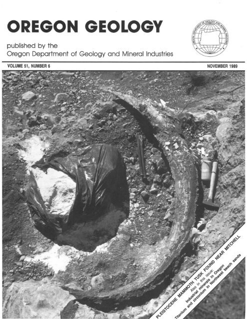
Recently excavated mammoth tusk on display in Prineville BLM office<br />
A mammoth tusk found eroding from a stream bank near Mitchell<br />
in May 1988 by Merle. Sandra, and Devin Simmons of Eugene (see<br />
cover photo) has been placed on prominent display in the lobby of<br />
the Prineville District Office of the U.S. Bureau of Land Management<br />
(BLM). Merle, a dental technologist, suspected that the rather strange<br />
looking white material was ivory from a tooth and alerted the John<br />
Day Fossil Beds National Monument. The staff there passed a sample<br />
and the information from Simmons along to BLM. Through an interagency<br />
agreement, the Park Service helped prOiect the tusk by<br />
applying glues to the weathered specimen and patrolling the location<br />
until the tusk could be excavated by paleontologist Dave Taylor of<br />
the Northwest Natural History Association.<br />
According to Taylor, the tusk is a greatly enlarged incisor tooth<br />
that most likely belonged to the columbian mammoth, or Mammuthus<br />
columbi. The columbian mammoth was large, even for an elephant,<br />
allaining a height of up to 13 ft at the shoulders. It was common<br />
during late Pleistocene time and ranged throughout North and Central<br />
America.<br />
BLM archaeologist Suzanne Crowley Thomas stated that the tusk,<br />
which was found in stream gravels with its tip lodged against a large<br />
boulder, was all that was left of a carcass that had probably washed<br />
downstream long ago.<br />
The tusk was found on land in Wheeler County that was recently<br />
acquired by BLM in the Sutton Mountain land exchange. The area<br />
is known to be rich in paleontological resources dated 34 10 54 million<br />
years old. This find is unique, however, because it is so recent.<br />
Before the tusk could be excavated, 6 ft of earth had to be removed<br />
from above the fossil, and space to work had to be cut into the<br />
steep hillside. Taylor, who led the excavation one hot weekend in<br />
August 1988, was assisted in the process by archaeologist Thomas<br />
and volunteers Bob Tavemia, Scott Thomas, and Merle and Sandra<br />
Simmons.<br />
The tusk was exposed, and plaster-soaked burlap strips were applied<br />
to form a protective jacket. Boards were added to stabilize the tusk,<br />
and finally the whole package was lifted onto a stretcher and carried<br />
downhill. The tusk then spent the next few months in a laboratory<br />
at Portland State University, while Taylor cut and peeled away the<br />
plaster jacket, applied more glues. and filled in some of the missing<br />
surface with plaster.<br />
After its return to central <strong>Ore</strong>gon, the tusk was placed in a specially<br />
designed case in the lobby of the Prineville BLM District Office<br />
along with photographs and descriptions of the excavation. The Bridge<br />
Creek mammoth tusk exhibit is proving to be a popular attraction<br />
Sandra Simmons helping in excavating the mammoth lusk she and<br />
her family found near Mitchell in 1988.<br />
and has been viewed by several hundred visitors since its unveiling<br />
on April 19, 1989.<br />
This tusk is a classic example of the way in which private citizens<br />
who make an important scientific discovery on public lands can report<br />
the find to the appropriate land managing agency or to a member<br />
of the professional community, thereby assuring that the discovery<br />
will be properly treated and preserved for all to study and enjoy.<br />
The casual use and collection of fossils have long been recognized<br />
as legitimate activities on public lands. Some restrictions do exist,<br />
however, which provide for the mamagement and protection of fossils<br />
of major scientific value. Generally, common invertebrate and plant<br />
fossils may be collected by private individuals without a permit. Exceptions<br />
can occur when the fossils are of high scientific value. Vertebrate<br />
fossils generally may be collected under permits issued by<br />
BLM or other appropriate authorities, and these permits are issued<br />
only to bona-fide scientific researchers and institutions.<br />
Opportunities are available, however, for private individuals to<br />
participate in scientific field studies through volunteer work with active<br />
research organizations such as colleges, universities, conservation organizations,<br />
and museums. For those who want 10 participate, there<br />
is ample opportunity to dig and learn through these organized research<br />
programs.<br />
BUvf Ne .... s. <strong>Ore</strong>gon and Washington<br />
(Col1linued from previous page)<br />
tending through '1984 (Neuendorf and Yost,<br />
1987). The <strong>Department</strong> has a noncirculating<br />
library of current and out-of-print periodicals,<br />
theses and dissertations, and published and unpublished<br />
repons, including reports written for<br />
the War Officc during World War II. The <strong>Department</strong><br />
also maintains files of unpUblished<br />
information on most of the commodities lisled<br />
in Table I. Summaries of these commodities<br />
were published in the Dt;partment's Bulletin<br />
64, Mineral and Waler Resources of <strong>Ore</strong>gon<br />
(Weissenborn, 1969). Comprehensive <strong>Department</strong><br />
studies on talc and bentonite have been<br />
published recently; a limestone survey is in<br />
press; a silica summary is in progress; and similar<br />
studies of other commodities are planned<br />
for future work.<br />
RE FE RENCES CITED<br />
Bates. R.L.. 1969 (1St ed. 1960). <strong>Geology</strong> of the<br />
industrial rocks and minerals, New York, Dover<br />
P ubli~ations. 459 p.<br />
Ferns. ML and Ramp, L.. 1988, Investigations of<br />
talc in <strong>Ore</strong>gon: <strong>Ore</strong>gon <strong>Department</strong> of <strong>Geology</strong><br />
and Mineral Industries Special Paper 18.52 p ..<br />
4 pis.<br />
Gray. JJ .. Geitgey. R. P .. and Baxter. G.L.. 1989.<br />
Bentonite in <strong>Ore</strong>gon: Oc~urrellCes, analyses, and<br />
economic poIential: <strong>Ore</strong>gon <strong>Department</strong> of <strong>Geology</strong><br />
and Mineral Indusuies Special Paper 20,<br />
28 p .• 3 pis.<br />
Harben. P.W., and Bates. R. L., 1984. <strong>Geology</strong> of<br />
the nonmetallics: New York. Metal Bulletin. Inc.,<br />
392 p.<br />
Industrial Minerals. 1967- : Worcester Park. U.K.,<br />
Metal Bulletin Journals Ltd.<br />
Lefond. SJ .. and othen. eels .. 1983. industrial minerals<br />
and rocks (nonmetallics other than fuel s),<br />
5th ed.: New York. Society of Mining Engineers<br />
of the American Institute of Mining, Metallurgical.<br />
and Petroleum Engineen. Inc., 2 v .. 1446 p.<br />
Leppert, D.E., 1988, An <strong>Ore</strong>gon cure for Bikini island?<br />
First results from the Zeolite Immobiliution<br />
Experiment: <strong>Ore</strong>gon <strong>Geology</strong>. v. 50. no_<br />
11/12. p. 140-141.<br />
Neuendorf. K.K.E., and Yost, K., eelS., 1987, Bibliography<br />
of the geology and mineral resources<br />
of <strong>Ore</strong>gon, 8th supplement, January I. 1980. to<br />
December 31. 1984: <strong>Ore</strong>gon <strong>Department</strong> of<strong>Geology</strong><br />
and Mineral Industries Bulletin 103, 176 p.<br />
U.S. Bureau of Mines. 1985. Mineral facts and problems.<br />
1985 edition: U.S. BureauofMines Bulletin<br />
675, 956 p.<br />
---1989. Minerals yearbook, 1987: U.S. Bureau<br />
of Mines , 3 v. (Latest year covered; for subsequent<br />
year, single chapters usually are published as preprints.)<br />
Weissenborn, A.E., ed., 1969, Mineral and water resources<br />
of <strong>Ore</strong>gon: <strong>Ore</strong>gon <strong>Department</strong> of <strong>Geology</strong><br />
and Mineral Industries Bulletin 64, 462<br />
0<br />
O REGON GEOLOGY, VOLUME 51, NUMBE R 6, NO VEMBER 1989<br />
129
Elemental composition of the very heavy nonmagnetic fraction of Pacific<br />
Northwest beach sands<br />
by Stephen E. <strong>Bin</strong>ney and Bilqees Azim, <strong>Department</strong> of Nuclear Engineering; and Curt D. Peterson, College of Oceanography, <strong>Ore</strong>gon<br />
State University, Corvallis, <strong>Ore</strong>gon 97331<br />
ABSTRACT<br />
Sieving, magnetic separation, and gravimetric separation were<br />
used to isolate the very heavy nonmagnetic (VHNM) fraction (specific<br />
gravity [sp grJ > 4.2) of a suite of Pacific Northwest beach<br />
samples. The VHNM samples were then analyzed by instrumental<br />
neutron activation analysis to detect the elemental concentrations<br />
present. Zirconium (Zr) and titanium (Ti) were the two most prominent<br />
elements observed, with Zr (as zircon) generally increasing<br />
and Ti (as rutile) generally decreasing from south to north. The<br />
zircon plus rutile concentrations were in the range of about 72<br />
to 100 percent (mean and standard deviation of 91.7 ± 8.2 percent)<br />
of the VHNM mass. Several other element were closely correlated<br />
with the major elements Zr and Ti.<br />
INTRODUCTION<br />
The very heavy nonmagnetic (VHNM) fractions (sp gr > 4.2)<br />
of a suite of Pacific Northwest beach samples were analyzed to<br />
determine their elemental compositions. These data could be used<br />
along with other data to estimate the economic mineral content<br />
of the VHNM fraction of offshore sands. Recent measurements<br />
of the elemental content of coastal placers along the northern California,<br />
<strong>Ore</strong>gon, and Washington beaches have concentrated on<br />
48 0<br />
the heavy (sp gr > 3.0) magnetic fraction (Peterson and <strong>Bin</strong>ney,<br />
1988) and the VHNM fraction (Azim, 1988) of these placers. This<br />
paper discusses the analysis of the VHNM fraction of samples<br />
collected from 14 beaches in this area. The study was originally<br />
designed to focus primarily on zircon, although the presence of<br />
rutile in the VHNM fraction expanded this scope somewhat.<br />
In the Klamath Mountain source area (provenance) of southern<br />
<strong>Ore</strong>gon and northern California, zircon is derived from a variety<br />
of igneous and metamorphic rocks. These primary source rocks<br />
range from Pre-Triassic to Late Jurassic in age and are distributed<br />
throughout the Klamath Mountain provenance (Irwin, 1960). Tertiary<br />
sedimentary rocks, derived in part from the Klamath Mountain<br />
terrane and from Rocky Mountain terranes to the east, might also<br />
supply second-cycle zircon to <strong>Ore</strong>gon Coast Range drainages. Kulm<br />
and others (1968) report that the abundance of zircon varies from<br />
1 to 13 percent in heavy-mineral assemblages (sp gr > 3.0) of<br />
the Klamath Mountain and <strong>Ore</strong>gon Coast Range rivers.<br />
SAMPLE DESCRIPTION AND PREPARATION<br />
The beach samples that were analyzed were chosen to span<br />
a wide geographic and geological range along the northern Pacific<br />
coast of the United States (Figure 1). Bulk samples were collected<br />
in March 1984 at mid-beach face sites on the southern side of<br />
headlands. Samples were taken down to 2 m below the winter-beach<br />
surface to obtain concentrated placer compositions at depth (Peterson<br />
and others, 1986).<br />
The first step in the sample separation process involved sieving<br />
about 100 g of the beach sand (0 to 2.5 at 0.25- intervals)<br />
to separate rock fragments and other larger particles from the remainder<br />
of the sample. All the particles coarser than 2.25 were<br />
discarded, leaving the fine grains consisting of relatively heavy<br />
particles.<br />
The major steps (Figure 2) in preparing the sieved samples<br />
for analysis were as follows:<br />
1. Removal of the light minerals from the heavy minerals at<br />
a sp gr of 3.0 by the use of sodium poly tungstate.<br />
Bulk sample<br />
Sieving<br />
44<br />
Fine fraction<br />
Sodium poly tungstate<br />
Heavy fraction<br />
CALIFORNIA<br />
126 0 122 0 1200<br />
Figure 1. Location of beach sample collection sites on Pacific<br />
Northwest beaches.<br />
Hand magnet<br />
Weakly magnetic + nonmagnetic!<br />
Figure 2.<br />
procedure.<br />
Strongly magnetic raction<br />
[ Franz separator h<br />
Nonmagnetic fraction!<br />
Sodium poly tungstatetun<br />
sten carbide<br />
Weakly magnetic fraction<br />
l<br />
Intermediate fraction,<br />
Schematic of bulk beach sample separation<br />
130 OREGON GEOLOGY, VOLUME 51, NUMBER 6, NOVEMBER 1989
2. Removal of the heavy magnetic minerals from the nonmagnetic<br />
heavy minerals by the use of a hand magnet and a Frantz<br />
magnetic separator.<br />
3. Ren10val of the intermediate minerals from the VHNM minerals<br />
at a sp gr of 4.2 by the use of a tungsten carbide-sodium<br />
po]ytungstate mixture.<br />
The purpose of the sodium poly tungstate separation was to<br />
achieve a separation of the fine fraction at a sp gr ::; 3.0, e.g.,<br />
removal of the light minerals such as quartz and feldspar. The<br />
sample was stirred into the solution and allowed to settle for about<br />
12 hours. Once separation had occurred, the light minerals were<br />
isolated by carefully immersing the beaker of solution into liquid<br />
nitrogen. The lighter particles were decanted, and the heavier particles,<br />
after thawing, were thoroughly washed in a filter to avoid<br />
Na and W contamination. After washing, the heavy fraction was<br />
dried in an oven at 80°C for 12 hours (or overnight).<br />
The magnetic separation process removed the magnetic fraction<br />
of the sample. A hand magnet was used first for the removal<br />
of strongly magnetic substances such as magnetite. This method<br />
was efficient and averted subsequent clogging in the Frantz isodynamic<br />
magnetic separator, in which standard settings were used<br />
for a more complete separation of the magnetic and nonmagnetic<br />
fractions.<br />
After the Frantz separation, a mixture of tungsten carbide and<br />
sodium poly tungstate was used to separate the VHNM fraction<br />
from the less dense nonmagnetic fraction. Zircon and rutile resided<br />
in the VHNM fraction (sp gr 4.6-4.7 and 4.2-4.3, respectively).<br />
After the separation process was completed. the VHNM fraction<br />
was examined under a microscope using a standard petrographic<br />
analysis method (Phillips and Griffen. 1981) and was found to<br />
consist mainly of translucent nonisometric minerals and trace<br />
amounts of opaque minerals. The VHNM samples were then<br />
weighed and heat sealed with a quartz rod into clean :V27-dram<br />
vials for analysis.<br />
METHOD OF ANALYSIS<br />
Sequential instrumental neutron activation analysis (INAA) was<br />
used to analyze the VHNM samples and determine elemental concentrations<br />
(Laul, 1979). Four reference standards were used: fly-ash<br />
powder (NBS 1633a), Columbia River Basalt Group powder<br />
(CRB3), a liquid U standard, and a liquid Zr standard. The CRB3<br />
standard is an <strong>Ore</strong>gon State University (OSU) standard that has<br />
been calibrated with the USGS BCR-l standard rock. The VHNM<br />
irradiation samples had masses in the range of 20 to 160 mg,<br />
although one sample had a mass of < 10 mg (all that was available).<br />
The samples and the standards were irradiated under identical conditions<br />
in the OSU TRIGA Reactor. The reactor was operated<br />
at a power level of 1 MW, corresponding to a thermal neutron<br />
flux of 1 x 10¹³ nlcm 2 -s in the ~newnatic transfer system (for<br />
the short irradiations) and 3 x 10 2 n/cm 2 -s in the rotating rack<br />
(for the long irradiations).<br />
For short irradiations, the samples were irradiated for two minutes<br />
and then allowed to decay for 10 minutes. The short-lived<br />
nuclides (representative of the elements Ti, AI, V, Mg, and Ca)<br />
were analyzed first for five minutes. After two to five hours, the<br />
samples were reanalyzed for 10 minutes to determine the elemental<br />
contents of Dy, Na, K, and Mn.<br />
For the long irradiation, the samples and the standards were<br />
irradiated for seven hours. After a decay period of seven to 14<br />
days, the samples were analyzed for three hours to determine the<br />
elemental concentrations of Fe, Co, As. Sb, Rb, Ba, La, Nd, Sm,<br />
Yb, Lu, W, and Np (representativeofU). The samples were allowed<br />
to decay for an additional 20 to 30 days and then analyzed for<br />
six hours to measure the concentrations of Sc, Cr, Co, Zn, Se.<br />
Sr, Sb, Cs, Ce, Eu, Th, Zr, Hf, Ta, and Pa (representative of Th).<br />
The data were collected using a p-type Princeton Gamma Tech<br />
Ge(Li) detector with a 13-percent efficiency (relative to a 7.62-cm<br />
by 7.62-cm NaI [Til detector at 1,332 keY) and a peak to Compton<br />
ratio of 47:1 at 1,332 keY. Dead times did not exceed 10 percent<br />
for any of the samples.<br />
RESULTS<br />
Results are referenced to the VHNM fraction sample masses,<br />
i.e., concentrations are expressed in parts per million (ppm) as<br />
Ilg of element per g of VHNM sample. Table 1 shows the concentrations<br />
(as ppm) of the major, minor, and trace elements in<br />
the VHNM samples,<br />
Zirconium was the most prominent element measured (INAA<br />
is not very sensitive to 0 or Si), with its abundance ranging from<br />
about 17 to 47 percent by weight (as the element Zr). The highest<br />
concentration of Zr (47.2 percent) occurred at Agate Beach (latitude<br />
'" 44.67° N.). (Note: the maximum possible Zr concentration is<br />
49.6 percent, the weight percentage of Zr in zircon.) Figure 3<br />
shows the variation of Zr concentration as a function of latitude.<br />
Concentration of Elemental Zr and Ti (%)<br />
60,---------------------------------------------,<br />
50<br />
40<br />
30<br />
20<br />
10<br />
o<br />
40<br />
+ x:/ /,\<br />
~<br />
~,<br />
'.'+<br />
-----"-_...--1.--.:1, +- /~_·+5v~_'··~'<br />
41 42 43 44 45<br />
Latitude, deg N<br />
I ~'_zr_ +"'_T_i _-_-8_,., Zr + iiJ<br />
46<br />
,-~.+<br />
47 48<br />
Figure 3. Zirconium and titanium concentrations in the VHNM<br />
fraction of beach samples.<br />
Titanium was the second most prominent element in the VHNM<br />
samples, with an elemental concentration ranging from about 2<br />
to 29 percent. The highest concentrations of Ti occurred at the<br />
four southernmost beaches (northern California and southern <strong>Ore</strong>gon).<br />
For the rest of the samples, the Ti concentration was less<br />
than about 8 percent of the VHNM sample mass, although Ocean<br />
Beach had a relatively higher concentration of Ti and a correspondinglylower<br />
Zrconcentration than neighboring beaches. Figure<br />
3 also shows the variation of Ti concentration as a function of<br />
latitude. Hafnium, which is always present with Zr in nature, closely<br />
followed the concentration trend of Zr in the VHNM samples.<br />
The concentration range of Hf was about 0.4 to I percent. The<br />
ratio of the concentration of Hf to the concentration of Zr + Hf<br />
varied only slightly, from 2.02 to 2.24 percent, with a mean and<br />
standard deviation of 2.13 and 0.08 percent, respectively.<br />
The other elements that occurred as major elements in the VHNM<br />
samples were AI, Ca, Ba, and Mg. Aluminum occurred in the<br />
range of about 0.3 to 6.5 percent. Calcium had a concentration<br />
range of 0.2 to 2.5 percent in 11 of the 14 samples. Concentrations<br />
of barium varied widely, and it appeared as a major. minor, or<br />
trace element in the various VHNM samples. Although Mg was<br />
present in the VHNM samples. accurate amounts could not be<br />
determined because it was discovered after the analyses that the<br />
Mg standard had chemically decomposed; hence Mg values are<br />
not reported.<br />
Vanadium occurred as a trace element in the VHNM samples,<br />
with concentrations ranging from 50 to 655 ppm. Uranium and<br />
Th were also present in the samples as trace elements with maximum<br />
OREGON GEOLOGY, VOLUME 51, NUMBER 6, NOVEMBER 1989 131
Table I. Elemental composition of the VHNM samples (ppm)<br />
sample Lat. Ti Al Ca V MIl Na K Dy Fe Co Rb Ba La<br />
Moonstone 41. 04 282359 8834 19864 664 0.0069 0.013
Table 2. Weight percent of zircon and rutile in the VHNM and<br />
heavy fractions<br />
VHNM fraction Heavy fraction<br />
Sample Zircon Rutile Swn Zircon Rutile<br />
Moonstone 33.3 47.2 BO.5 0.01 0.01<br />
North Fern Canyon 42.3 4B.0 90.3 0.32 0.36<br />
Crescent City 72.2 21.5 93.7 0.19 0.06<br />
Hunters Cove 76.4 26.0 102.4 0.53 0.18<br />
Nesika 82.6 10.7 93.3 0.13 0.02<br />
Port Orford 89.5 5.1 94.6 6.46 0.37<br />
Cape Blanco 84.3 10.4 94.7 2.27 0.28<br />
Sacci 87.6 4.3 91.9 4.56 0.22<br />
Heceta 91.9 8.6 100.5 0.93 0.09<br />
Agate 94.9 2.6 97.5 7.56 0.21<br />
Roads End 78.5 4.9 83.4 0.34 0.02<br />
Meriweather 88.9 4.1 93.0 4.65 0.22<br />
Ocean Beach 58.2 13.6 71.8 0.33 0.08<br />
Beach #3 93.0 3.6 96.6 0.82 0.03<br />
percent when expressed as the mineral (zircon plus rutile) weight<br />
percent. Hence the Ti plus Zr concentrations in the VHNM samples<br />
vary less than 10 percent (l a) over a distance of more than<br />
700 km along the Pacific coastline from northern California to<br />
central Washington and comprise nearly 100 percent of the VHNM<br />
sample.<br />
A linear regression was performed between each pair of elements<br />
measured in the VHNM samples. The corresponding values of<br />
the correlation coefficient are shown in Table 3. The correlation<br />
coefficient for Ti and Zr was - 0.911, which is a typical correlation<br />
for a predominantly binary mineral system.<br />
As indicated earlier, the ratio of Zr to Hf is quite constant<br />
over the entire suite of samples, with Hf and Zr having a relatively<br />
high correlation coefficient (+0.986). In particular, the eight southernmost<br />
beaches, which are within the Klamath Mountain drainage,<br />
had a Zr/Hf ratio of 46.1 ± 1.6, while the six northernmost beaches<br />
(Coast Range drainages) showed no statistical difference in their<br />
Zr/Hf ratios (45.7 ± 2.2). This behavior is to be expected because<br />
of the similar chemical nature of Zr and Hf.<br />
Most of the chromite in these beach sands was apparently combined<br />
in sand grains along with magnetite and hence was removed<br />
in the magnetic separation. Chromium had a moderately strong<br />
correlation with Ti (+0.708) in the VHNM samples. Although present<br />
only as a trace element, the higher Cr measurements in the<br />
AI ... Ie Co Ba ..<br />
.. !b<br />
Table 3. Correlation coefficients for elements in the VHNM samples<br />
four southernmost beaches are consistent with previous measurements<br />
(Peterson and <strong>Bin</strong>ney, 1988) of higher chromite concentrations<br />
in the magnetic fraction of the samples from these same<br />
beaches. The trace element V was also strongly correlated (+0.974)<br />
to the major element Ti, with its highest concentration in the two<br />
southernmost beaches.<br />
Uranium had a relatively strong correlation with Zr (+0.937).<br />
Some of the lanthanides followed a similar trend with Zr, e.g.,<br />
La (+0.820), Sm (+0.748), Yb (+0.737), Lu (+0.964), and Dy<br />
(+0.717). Such relatively large correlation coefficients suggest the<br />
possibility that these trace elements could be used as tracers for<br />
zircon source studies.<br />
Some anomalously low values were associated with some of<br />
the rare-earth concentrations (Ce, Nd, and Lu) in the VHNM samples<br />
from Crescent City, Nesika, and Ocean Beach. The U values were<br />
also questionable at these beaches. These anomalies have been<br />
attributed to the fact that (1) low gamma-ray energies were used<br />
for analysis of these elements and (2) the VHNM sample mass<br />
available was small (except for Crescent City), both of which produced<br />
large uncertainties in the results.<br />
SUMMARY<br />
A separation scheme was devised to separate the VHNM fraction<br />
from the bulk beach sample that contained minerals of various<br />
magnetic susceptibilities and specific gravities. The VHNM samples<br />
were analyzed by sequential INAA to detect the elemental concentrations<br />
present.<br />
Zircon was present as the major mineral in the VHNM samples,<br />
with a weight percent ranging from 58 percent to 95 percent for<br />
most of the samples. Samples from the southernmost beaches (northern<br />
California) contained an appreciable amount of rutile along<br />
with the zircon. The zircon and rutile served to substantiate the<br />
previously known economic importance of the Pacific Northwest<br />
beach and continental-shelf sands (Kulm and Peterson, 1989).<br />
ACKNOWLEDGMENTS<br />
Margaret Mumford, OSU College of Oceanography, provided<br />
valuable assistance during the sample-separation phase of this study,<br />
as well as the XRD analyses. Mike Conrady similarly assisted<br />
in the data collection and analysis at the OSU Radiation Center.<br />
lou u Sc Cr ... Sa Zr IIf<br />
;rt -0.1580 0,3697 0.9738 0.2863 -0.0206 -0.8671 0.8163 -0.1016 0.5163 -0.8279 -0.7772 -0.7461 -0.9485 -0.9349 -0.2517 0.7075 0.4168 0.4237 0.4665 -0.0172 -0.3687 -0.9111 -0.9084 -0.5238<br />
AI 0.5695 -0.0242 0.5176 0.,.,934 0.3164 0.4834 0.9237 -0.1454 0.1152 0.1878 0.0375 -0.0147 -0.9325 -0.4412 -0.3997 -0.8156 -0.4102 0.0792 0.7661 0.6802 -0.1753 -0.0975 0.0699<br />
ca 0.4690 0.8723 0.4374 0.0422 0.8782 0.9312 0.6987 -0.5247 -0.4752 -0.5445 -0.6421 0.0040 -0.1776 -0.2630 -0.5105 -0.5610 0.7285 0.8157 0.4994 -0.6513 -0.5902 -0.0314<br />
...<br />
Ie<br />
By<br />
Fe<br />
Co<br />
Ba<br />
..<br />
!b<br />
...<br />
u<br />
Sc<br />
Cr<br />
...<br />
Sa<br />
Ce<br />
...<br />
!b<br />
Zr<br />
IIf<br />
0.3362 -0.0395 -0.7849 0.8537 -0.1834 0.4973 -0.8266 -0.6727 -0.6382 -0.9555 -0.6477 -0.3794 0.6553 0.2652 0.5127 0.5440 0.1213 -0.2513 -0.9497 -0.9326 -0.5190<br />
0.5305 -0.1471 0.5985 0.9972 0.6899 -0.2803 -0.3396 -0.4120 -0.4618 -0.4904 0.0041 -0.2142 -0.1701 -0.8291 0.6813 0.7096 0.2567 -0.5376 -0.4966 -0.0367<br />
0.0748 -0.2975 0.7724 -0.3117 -0.1737 -0.2904 -0.4135 -0.1663 -0.1936 -0.1534 -0.4631 -0.2378 -0.5013 -0.1871 0.5063 0.4052 -0.1178 -0.0400 0.5829<br />
-0.6830 0.1347 -0.3985 0.7987 0.8254 0.7654 0.9233 0.9388 0.1090 -0.7361 -0.2739 -0.2718 -0.2354 0.2798 0.6570 0.7166 0.7479 0.5373<br />
-0.1579 0.7043 -0.7350 -0.4056 -0.3724 -0.7922 -0.7848 -0.0096 0.1667 0.0000 1.0000 0.8917 0.5312 -0.3976 -0.8884 -0.8803 -0.5883<br />
0.3999 0.2757 0.1833 0.0054 0.0912 -0.0480 0.4866 -0.5025 0.0000 -1.0000 0.5606 0.4591 0.6582 0.2383 0.3191 0.4765<br />
-0.2115 -0.3694 -0.4264 -0.3559 -0.4211 0.3749 0.2632 0.5562 -1.0000 0.6492 0.2584 0.0299 -0.4783 -0.4705 -0.5666<br />
0.9375 0.9210 0.9131 0.9159 0.3746 -0.3892 -0.8021 -0.7592 -0.3961 -0.1230 0.3627 0.8205 0.7771 0.7505<br />
0.9625 0.9519 0.9644 0.0786 -0.4242 -0.6377 -0.4838 -0.2520 0.1845 0.5813 0.7484 0.7762 0.7424<br />
0.9956 0.9923 0.0223 -0.3096 -0.1456 -0.4933 -0.2768 0.0735 0.4578 0.7374 0.7519 0.7308<br />
0.9915 0.4253 -0.5543 -0.0638 -0.5339 -0.4926 -0.1859 0.4106 0.9636 0.9372 0.8697<br />
0.3612 -0.5814 -0.2062 -0.3968 -0.4752 -0.2043 0.4265 0.9365 0.9103 0.8897<br />
-0.2774 0.7100 -0.8652 0.2155 -0.2417 -0.2664 0.4057 0.3615 -0.0059<br />
0.2349 -0.0110 -0.1057 -0.3631 -0.5185 -0.4701 -0.5033 -0.5112<br />
0.1953 -0.9087 -0.8493 -0.4108 0.2032 0.1742 -0.0014<br />
-0.3758 -0.7688 -0.4104 -0.5754 -0.5334 -0.1037<br />
0.3743 -0.1632 -0.6503 -0.6441 -0.3123<br />
0.6734 -0.2885 -0.1923 0.1266<br />
0.1830 0.3071 0.2616<br />
0.9861 0.4622<br />
0.4902<br />
OREGON GEOLOGY, VOLUME 51, NUMBER 6, NOVEMBER 1989 133
Nuclear reactor services and INAA detection equipment were provided<br />
by the Radiation Center. Sample collection and initial processing<br />
were carried out with support from the <strong>Ore</strong>gon State<br />
University Sea Grant Program, under Grants No. NA81 AA -0-00086<br />
(Projects R/CP-20 and R/CP-24) and No. NA85AA-0-SG095 (Project<br />
R/CM-31), and from the <strong>Ore</strong>gon Division of State Lands. This<br />
research was conducted as a portion of the second author's master's<br />
thesis in Nuclear Engineering at <strong>Ore</strong>gon State University.<br />
REFERENCES CITED<br />
Azim, B., 1988, Elemental analysis of zircon samples from Pacific Northwest<br />
beaches by INAA: Corvallis, <strong>Ore</strong>g., <strong>Ore</strong>gon State University <strong>Department</strong><br />
of Nuclear Engineering master's thesis.<br />
Irwin, W.P., 1960, Geologic reconnaissance of the northern Coast Ranges<br />
and the Klamath Mountains, California, with a summary of the mineral<br />
resources: California Division of Mines Bulletin 179, 80 p.<br />
Kulm, L.D., and" Peterson, C.D., 1989, Preliminary economic evaluation<br />
of continental shelf placer deposits off Cape Blanco, Rogue River,<br />
and Umpqua River: <strong>Ore</strong>gon <strong>Department</strong> of <strong>Geology</strong> and Mineral Industries<br />
Open-File Report 0-89-12, in press.<br />
Kulm, L.D., Scheidegger, K.F., Byrne, J.v., and Spigai, J.J., 1968, A preliminary<br />
investigation of the heavy-mineral suites of the coastal rivers<br />
and beaches of <strong>Ore</strong>gon and northern California: <strong>Ore</strong>gon <strong>Department</strong><br />
of <strong>Geology</strong> and Mineral Industries, <strong>Ore</strong> <strong>Bin</strong>, v. 30, no. 9, p. 165-180.<br />
Laul, J.C., 1979, Neutron activation analysis of geological materials: Atomic<br />
Energy Review, v. 17, p. 603-695.<br />
Peterson, C.D., and <strong>Bin</strong>ney, S.E., 1988, Compositional variations of coastal<br />
placers in the Pacific Northwest, USA: Marine Mining, v. 7, p. 397-416.<br />
Peterson, C.D., Scheidegger, K.F., and Komar, P.D., 1986, Distribution,<br />
geometry, and origin of heavy-mineral placer deposits on <strong>Ore</strong>gon<br />
beaches: Journal of Sedimentary Petrology, v. 54, p. 86-87.<br />
Phillips, w.R., and Griffen, D., 1981, Optical mineralogy of the nonoplUJ!!.e<br />
minerals: San Francisco, W.H. Freeman and Company, p. 677. U<br />
Records available at Wyoming<br />
The International Archive for Economic <strong>Geology</strong> (I.A.E.G.)<br />
at the American Heritage Center of the University of Wyoming<br />
offers a remarkable collection of documents for public use as a<br />
tool for scientific, historical, and commercial research. For <strong>Ore</strong>gon,<br />
this collection contains 130 report files, 520 documents, 46 maps,<br />
and 135 related documents.<br />
Through a gift from the ARCO Coal Company, the I.A.E.G.<br />
now has made the records of the Anaconda Company Geological<br />
<strong>Department</strong> (1895-1985) available to the public. The collection<br />
represents the largest body of private mineral and geological data<br />
available.<br />
The Anaconda Collection contains 1.8 million documents and<br />
maps including prospect evaluations, mine examinations, operating<br />
records from Anaconda properties, and studies of broad regional<br />
or topical interest. It is accessible through a computer inventory,<br />
from which printouts of specific searches are available. The collection<br />
is made available and supports itself entirely through user<br />
fees.<br />
The I.A.E.G. is a repository and research facility for original<br />
manuscripts from the field of economic geology. In addition to<br />
the Anaconda Collection, it holds files from more than 170 individual<br />
geologists and corporations. More information on the collections,<br />
services offered, and fees for use can be obtained from<br />
International Archive of Economic <strong>Geology</strong>, University of Wyoming,<br />
Box 3924, Laramie, WY 82071, phone (307) 766-3704.<br />
--lA.E.G. news release<br />
REMEMBER TO<br />
RENEW<br />
If the code number on your address label ends in "1289," that<br />
means your subscription expires with the last issue of 1989. Please<br />
use the renewal form on the last page to make sure you will<br />
continue receiving <strong>Ore</strong>gon <strong>Geology</strong>. And while you are at it-why<br />
not consider a gift subscription for a friend? 0<br />
DOGAMI Governing Board appOints new<br />
chairperson<br />
Sidney R. Johnson, president of Johnson Homes in Baker, has<br />
been appointed chair of the Governing Board of the <strong>Ore</strong>gon <strong>Department</strong><br />
of <strong>Geology</strong> and Mineral Industries (DOGAMI) for a oneyear<br />
term, succeeding Donald A. Haagensen of Portland.<br />
Johnson .is currently serving both his second four-year term<br />
as a member of the Board and his second term as chairperson.<br />
He has been a board member since 1983 and served as chairperson<br />
in 1985-1986. Ronald K. Culbertson of Myrtle Creek also serves<br />
on the three-member Board. D<br />
BLM names new state director<br />
D. Dean Bibles, currently U.S. Bureau of Land Management<br />
(BLM) state director for Arizona, has been named BLM state director<br />
for <strong>Ore</strong>gon and Washington. He will succeed Charles W.<br />
(Bill) Luscher who retired September 1.<br />
Bibles is a 32-yearveteran ofBLM and has held key martagement<br />
positions in the agency since 1967. He became state director in<br />
Ariwna in 1982.<br />
Bibles has received several awards, including the Interior<br />
<strong>Department</strong>'s top recognition, the Distinguished Service Award,<br />
and the federal government's top award for senior service leaders,<br />
the Distinguished Executive nomination. In 1985 and 1988, he<br />
received awards in Arizona by the state's Parks and Conservation<br />
Association, Wildlife Foundation, and Nature Conservancy chapter.<br />
In making the appointment, BLM Director Cy Jamison said<br />
that Bibles "is fully committed to management of our nation's<br />
public lands in that multiple-use context which will position BLM<br />
to fully meet the public's demands for natural-resource uses in<br />
the 1990's and into the 21st century.<br />
-BLM news release<br />
Photographer Leonard Delano, Sr., dies<br />
Leonard Delano, Sr., retired commercial photographer, died September<br />
16, 1989, in a Milwaukie hospital. He and his wife Emily<br />
were active for more than 48 years in commercial photography,<br />
which included aerial-photography mapping work. Their companies,<br />
Delano Photographics, Inc., and Western Mapping Company,<br />
produced a significant collection of Pacific Northwest photographs,<br />
many of which have been given to the <strong>Ore</strong>gon Historical Society.<br />
John E. Allen, Emeritus Professor of <strong>Geology</strong> at Portland State<br />
University, said this of Delano, "Few professional photographers<br />
have contributed so much to geological understanding of the landscape<br />
as has Leonard Delano. This is because on every flight,<br />
Delano Photographics always made it a policy to also take a few<br />
spectacular oblique photographs. They were usually not paid for<br />
these, but when the shots were needed by a geologist for a superb<br />
illustration, Delano Photo graphics allowed them to be used for<br />
minimal or no charge."<br />
Delano was one of the lucky few people who have the eye<br />
of an artist, the skill of a photographer, an interest in geology,<br />
and the opportunity to fly and photograph. Through his photographs,<br />
he shared his special vision with the rest of us. The <strong>Ore</strong>gon <strong>Department</strong><br />
of <strong>Geology</strong> and Mineral Industries used many of Delano's<br />
photographs-as did almost anyone else who has published information<br />
about the geology of the state.<br />
Delano is survived by his wife Emily, sons Douglas and Leonard<br />
Jr., a brother, a sister, and seven grandchildren. D<br />
134 OREGON GEOLOGY, VOLUME 51, NUMBER 6, NOVEMBER 1989
Industrial minerals: Can we live without them?<br />
by Hal McVey, Mineral Marketing, Inc.*<br />
Few people realize the importance of industrial minerals in<br />
our everyday lives. Perhaps a trip through a normal working day<br />
will underscore our reliance upon these nonmetallic minerals. The<br />
products and processes that contain industrial minerals or utilize<br />
industrial minerals in the manufacturing process are highlighted<br />
in bold face.<br />
As we step out of bed in the morning, we place our feet on<br />
the carpet (calcium carbonate/limestone is used in the carpet backing).<br />
We fmd our way to the kitchen and switch on the electric<br />
light and the coffee pot, which are made of either glass or ceramics<br />
(both glass and ceramics are made entirely from industrial minerals-silica<br />
sand, limestone, talc, lithium, borates, soda ash, and<br />
feldspar). As we enter the kitchen, we find we are now on linoleum<br />
(calcium carbonate, clay, and wollastonite) or on ceramic tile.<br />
While the coffee is being prepared, we sit down to read the<br />
newspaper and at the same time we realize that we have to take<br />
a trip today, so we consult our Official Airline Guide and then<br />
have to refer to the Yellow Pages of the phone book for the phone<br />
number of the airline. (All of these papers are filled with kaolin<br />
clay and use limestone, sodium sulfate, lime, and soda ash in<br />
the processing.)<br />
The coffee is prepared, and we fix a piece of toast and sneak<br />
a piece of cake from last night's party (bakery items such as<br />
bread contain gypsum as an ingredient, and cakes have a high<br />
content of gypsum in the icing). The plate from which we are<br />
eating is composed of glass, ceramics, or china, the last being<br />
a special form of ceramics. We might also feel inclined to have<br />
a full breakfast and even contemplate what we'll have for lunch<br />
and what has to be prepared for the evening meal. Regardless,<br />
all of the food that we eat every day relies completely on industrial<br />
minerals for its growth and production. (All fertilizers are composed<br />
of some combination of potash, phosphates, nitrogen, sulfur,<br />
and other minor minerals. The acidity of soils must be regulated<br />
with gypsum, limestone, or sulfur. In fact, without industrial minerals,<br />
there could not be any modem-day agriculture as we now<br />
know it.)<br />
Let's now start getting to go to work. We brush our teeth with<br />
toothpaste (calcium carbonate/limestone/sodium carbonate).<br />
Women put on lipstick (calcium carbonate and talc) and powder<br />
(talcum), and men might prepare their hair with hair cream (calcium<br />
carbonate). Other forms of makeup would have various minerals<br />
as a constituent. The lavatory counter top in the bathroom where<br />
we are standing is a nice synthetic marble or synthetic onyx<br />
(titanium dioxide, calcium carbonate, and alumina hydrate). The<br />
sinks, lavatories, toilets, and similar fixtures throughout the house<br />
are kept shiny with cleansers (silica, pumice, diatomite, feldspars,<br />
and limestone). Kitchen and bathroom tiles are installed, are kept<br />
in place, and maintain their waterproof condition with putty and<br />
caulking compounds (limestone and gypsum).<br />
Just before we leave, we want to brighten up our wardrobe<br />
with some form of jewelry (all precious and semiprecious stonesopal,<br />
amethyst, aquamarine, topaz, garnets, diamonds, etc., are industrial<br />
minerals). There is a less attractive task to do at the last<br />
* This paper was first presented at a U.S. Geological Survey and California<br />
Division of Mines and <strong>Geology</strong> seminar on February 15 and 16,<br />
1989. It is reprinted with permission from Industrial Minerals, in which<br />
it appeared in April 1989 (no. 259, p. 74 and 75). Further information<br />
on Industrial Minerals <strong>magazine</strong> can be obtained from the publisher's U.S.<br />
office at 220 Fifth Avenue. 10th Floor, New York, NY 10001, telephone<br />
1-800-METAL 25 (in the U.S.) or 212-213-6202.<br />
minute, changing the kitty litter (attapulgite, montmorillonite, zeolites,<br />
diatomite, pumice, or volcanic ash).<br />
As we walk outside, we make a mental note that we have<br />
to have the composite roof fixed. (Fiberglass is composed of<br />
almost the same ingredients as regular glass-silica, borates, limestone,<br />
soda ash, and feldspar. Fiberglass and asphalt, along with<br />
lesser quantities of either talc, silica sand, or limestone, comprise<br />
composition roofmg.) We are pleased to see that the fiberglass<br />
siding on our home that we have just installed looks so nice.<br />
As we get in the car, we think that we will have to do planting<br />
and gardening this evening. In addition to fertilizers, we will<br />
have to buy some soil amendments and planting mixes today.<br />
(Vermiculite, perlite, gypsum, zeolites, or peat make for better<br />
growth.)<br />
Once we leave for work, we are really employing industrial<br />
minerals. Our automobile is literally composed of industrial minerals.<br />
Starting from the ground up, tires contain clays and calcium<br />
carbonate, and the mag wheels are made from dolomite and magnesium.<br />
All of the glass in the car is made entirely from minerals,<br />
as is the fiberglass body now becoming popular on many models.<br />
Many ofthe components in a car are now being made of composites,<br />
which are usually combinations of fiberglass and plastics. Plastics<br />
require calcium carbonate, wollastonite, mica, talc, clays, and silica<br />
for their manufacture. So, as we drive to work, we are enjoying<br />
the value of numerous industrial minerals, from the bumpers to<br />
the dashboard to the radiator cap and the floor mats.<br />
The paint that makes our car so attractive is composed in<br />
large part from industrial minerals-titanium dioxide, kaolin clays,<br />
calcium carbonate, micas, talc, silica, wollastonite, and others. In<br />
fact, every speck of all paints that we will encounter today, from<br />
that on our house to the stripe down the middle of the road and<br />
the interior of our offices and elsewhere, will be composed mainly<br />
of industrial minerals.<br />
Modern transportation is almost entirely reliant upon industrial<br />
minerals, and this does not stop with just the car. Gasoline and<br />
lubricants depend on industrial minerals, since the drill bit that<br />
originally discovered the crude oil was faced with industrial diamonds.<br />
Drilling fluids, used for ease of well drilling, are made<br />
almost entirely from barites, bentonite, attapulgite, mica, perlite,<br />
and others. It is necessary to employ clays and zeolites in the<br />
catalytic cracking process for crude petroleum to arrive at gasoline<br />
and lubricants.<br />
On our way to work, we don't think about it, but we are literally<br />
riding on industrial minerals. Concrete pavement is composed<br />
of cement and aggregates. Aggregates are themselves industrial<br />
minerals-sand and gravel or crushed stone, such as limestone,<br />
dolomite, granite, lava, etc. Cement is manufactured from limestone,<br />
gypsum, iron oxide, clays, and possibly pozzolan. Even<br />
asphaltic pavement or blacktop has industrial minerals as aggregates.<br />
The building we are about to enter is made of industrial minerals.<br />
If it is a concrete or stone or brick building, it is entirely made<br />
from industrial minerals. If there are steel structural members,<br />
the steel production process required chromite for fluxing, bentonite<br />
for pelletizing, and, perhaps, chromite for hardening. The making<br />
of steel requires the use of high-grade refractory bricks and shapes<br />
made from bauxite, chromium, zircon, silica, graphite, kyanite,<br />
andalusite, sillimanite, and clays. Fiberglass balts may be used<br />
for insulation in our office buildings as thay are in our homes.<br />
Upon entering, we are often enclosed by wallboard or sheetrock<br />
(gypsum with fire retardant additives, such as clays, perlite, ver-<br />
OREGON GEOLOGY, VOLUME 51, NUMBER 6, NOVEMBER 1989 135
miculite, alumina hydrate, and borates) joined together with joint<br />
cement (gypsum, mica, clays, and calcium carbonates). Certainly<br />
the plate-glass windows are made entirely from industrial minerals.<br />
The noors or decks between floors will probably be made from<br />
concrete using lightweight aggregate (perlite, vermiculite, zeolites,<br />
or expanded shales).<br />
To begin our work, we may pick up a pencil (graphite and<br />
clays) and make a list of things to do. One of the first items<br />
is to send out a few invoices that are backed with self-contained<br />
carbon paper (bentonite or other clays or zeolites). There are<br />
some articles to be ordered, so we pick up a catalog or <strong>magazine</strong><br />
and unconsciously like the glossy feel of the fine paper, which<br />
is caused by a high content of kaolin clay or calcium carbonate<br />
along with titanium dioxide for extreme whiteness. Almost every<br />
sheet of paper that we use today will have used industrial minerals,<br />
such as talc, in its manufacturing process or will contain minerals<br />
as fillers and coaters. Even some inks will contain calcium carbonate<br />
or other fillers.<br />
The morning has worn on, and it is time for a break. In addition<br />
to the coffee in the coffee cup (remember, it is made of industrial<br />
minerals), we decide to heat up a roll, and we place it in or on<br />
a microwaveable container (plastics filled and reinforced with<br />
talc, calcium carbonate, titanium dioxide, or clays).<br />
While on break, we commence to ponder what we will do<br />
for the weekend and know that there are a lot of recreational<br />
devices we would love to employ. These include golf clubs, tennis<br />
rackets, fishing rods, and skis. All of these are now commonly<br />
made from graphite, or, a slightly "older" material, fiberglass. Even<br />
if we are planning a backpacking trip, our pack frame and pots<br />
and pans will be made of aluminum (all aluminum, for whatever<br />
usage, originates with bauxite, one of the most widely utilized<br />
industrial minerals).<br />
Communications equipment employs numerous industrial<br />
minerals. The standard product of the industry for many years<br />
has been the silicon chip, which is made from quartz or silica,<br />
as the name implies. Optical fibers made from glass are replacing<br />
some copper wiring. The television screen or computer monitor<br />
is made of glass, but critical tubes contain phosphors made from<br />
the rare earths or lanthanides, a family of industrial minerals. Even<br />
the superconducting materials that are presently getting so much<br />
attention utilize industrial minerals (yttrium, lanthanides, titanium,<br />
zirconium, and barites) in their manufacture.<br />
After a hard day at the office, we drop in for refreshments<br />
with our friends. A glass of fruit juice, wine, or beer would<br />
be refreshing, but all of these liquids use either perlite or diatomite<br />
as filter aids in their purifying and clarifying processes. If we<br />
should add sugar to any of our drinks, we are enjoying the benefits<br />
of industrial minerals, since limestone and lime are basic to the<br />
production of sweeteners. And, of course, our refreshments will<br />
be served in ceramic mugs or glasses composed entirely of our<br />
friends, the industrial minerals.<br />
Filtering and purification are major duties of the industrial minerals.<br />
Our drinking water uses minerals for purifying and clarification<br />
(limestone, lime, and salt), as do the waste water treatment<br />
plants (zeolites, soda ash, lime, and salt). The vegetable oils we<br />
use are filtered by clays, perlite, or diatomite. And equally important<br />
to recreation is the utilization of all the minerals mentioned in<br />
this paragraph for the filtration and purification of water in swimming<br />
pools.<br />
When we arrive home, we are not yet through with our exposure<br />
to our mineral friends. If we have to take medicine or pharmaceuticals,<br />
we may chew antacid pills essentially made of calcium<br />
carbonate. For upset stomachs, there are Milk of Magnesia (magnesia/dolomite)<br />
or Kaopectate (kaolin) and others made from clays<br />
such as attapulgite. And, who can forget the lovely barium "cocktail"<br />
(barites), which it is necessary to drink before getting X-rayed<br />
for gastrointestinal occurrences. Not to mention tincture of iodine<br />
(iodine) for all those cuts and bruises. And, the lithium that is<br />
used to treat mental disorders started out as an industrial mineral.<br />
Rounding out the picture are such diverse uses as abrasives<br />
for sandblasting ships or for making sandpaper for home or<br />
workshop use, as well as emery boards for our fingemails or<br />
polishing compounds for our silverware and other items. Abrasives<br />
are made from pumice, diatomite, silica, gamet, corundum, and<br />
emery. Or, porcelain figurines (silica, limestone, borates, and soda<br />
ash) for our what-not shelf and plaster of paris statues (gypsum)<br />
for our lawn.<br />
Almost finally, it must be mentioned that one of the most basic<br />
table ingredients is an industrial mineral, namely salt. In fact,<br />
it is so basic that it was historically used as a medium of trade<br />
or payment, as implied in our word "salary." And truly finally,<br />
our names and dates of birth and death will be inscribed on a<br />
gravestone (marble or granite).<br />
The foregoing is meant to provide a broad insight into the<br />
importance of industrial minerals in our everyday life and to emphasize<br />
how much our lives would be altered without ready and<br />
economical access to these fundamental constituents. 0<br />
On recreational gold panning<br />
in <strong>Ore</strong>gon<br />
This article is adapted from "The Lure of Gold, " hy Mellngeroi<br />
of the U.S. Bureau of Land Management (BLM), Rosehurg District,<br />
and puhlished in a recent issue of the newsletter BLM News,<br />
<strong>Ore</strong>gon and Washington.<br />
'There's nothing quite like seeing your first gold flake shining<br />
against the sun. The yellow flakes sparkle like no other sight,<br />
and the sense of finding a bonanza leaves at least a few first-time<br />
miners giddy." With that glowing description begins an article<br />
on placer mining in the June 1989 issue of Trailer Life, a national<br />
<strong>magazine</strong> for recreational-vehicle enthusiasts. The article talks about<br />
the basic techniques (such as panning), equipment needed, and<br />
possible locations.<br />
Because the primary location recommended is on Cow Creek<br />
in the BLM Roseburg District, BLM mining engineer John Kalvels<br />
has been busier than usually answering questions from the public.<br />
"We get all kinds," said Kalvels, "from the casual tourist who<br />
knows next to nothing about gold to the experienced dredger who<br />
asks only about mining claims. Some weeks we might get a dozen<br />
letters and another dozen walk-ins and telephone callers."<br />
The discouraging fact is that most of the public land on Cow<br />
Creek is covered by mining claims. It is off limits, and miners<br />
have been known to be rather testy when running off claim jumpers.<br />
About the only spot on public land along Cow Creek still open<br />
to the public is in the vicinity of Darby Creek, about 20 mi southwest<br />
of Riddle. Currently, 20 acres have been withdrawn from mining<br />
entry there, and BLM is considering the establishment of a five-acre<br />
recreational gold-panning site within this area.<br />
Kalvels has been a mining engineer for the Roseburg District<br />
for quite a while, and his knowledge of local geology, promising<br />
locations, and tall tales keeps his customers satisfied, even though<br />
he does not have much prime real estate to offer to gold panners.<br />
"There will always be people lured by the romance of gold mining,"<br />
Kalvels says. "Part of it is the price paid for gold. At nearly $400<br />
an ounce, it ranks among the most valuable materials on earth.<br />
The rest is more intangible-tied in with mystery and challenge."<br />
These intangibles are behind the recreational aspects of placer<br />
mining. Many of the first-time miners on Cow Creek do not leave<br />
with enough gold to pay for the gasoline it took to drive out<br />
there. But a fair number will come back, dedicated not to what<br />
they take home but to doing it and being there. 0<br />
136 OREGON GEOLOGY, VOLUME 51, NUMBER 6, NOVEMBER 1989
Industrial Minerals Forum meets in Portland<br />
by Ronald P. Geitgey, O(('go/l <strong>Department</strong> of <strong>Geology</strong> and Mineral Industries<br />
The Forum Of} the <strong>Geology</strong> of Industrial Minerals is a loosely<br />
knit non-organization of specialists involved in various aspects<br />
of industrial minerals exploration, analysis, markeling, and production.<br />
Each year a different state or provincial geological survey<br />
hosts the meeting and publishes the papers presented at the Forum.<br />
During the firSI week in May of this year, the 25th Forum<br />
on the <strong>Geology</strong> of Industrial Minerals was held in Portland, <strong>Ore</strong>gon.<br />
hosted by the <strong>Ore</strong>gon <strong>Department</strong> of <strong>Geology</strong> and Mineral Industries<br />
and the Washington Division of <strong>Geology</strong> and Earth Resources.<br />
This is the first time the Forum has met in a West Coast Slate,<br />
and formany oCtile 120 participants from the United States. Canada.<br />
and Great Britain, it was their first visit to this area. About 45<br />
persons were from the Pacific Northwest. The remainder were<br />
from the eastern and midwestern states. Thirty-five percent were<br />
government employees, and sixty-five percent were employed in<br />
private indusuy. The Forum provided an opponunity forpanicipants<br />
to learn about industrial minerals activities in the Pacific Nonhwest<br />
and to meet the industrial minerals specialists working in this region.<br />
The Forum consisted of technical sessions, a local field tri p.<br />
and a three-day field trip to eastern and central <strong>Ore</strong>gon. Seventeen<br />
tcx:hnical papers were presented, including surveys of industrial<br />
mineral production and occurrences in Idaho. Montana. <strong>Ore</strong>gon,<br />
Washington, and British Columbia. Other papers described specific<br />
commodities, including bentonite. limestone. pozwlans, rare earths.<br />
talc. and zeolites, and two papers discussed various methods and<br />
problems in laborabory analysis of industrial minerals.<br />
The Portland ponion of the Forum concluded with a field trip<br />
to local industrial mineral producers, shippers. and users. Ross<br />
Island Sand and Gravel provided a tour by barge of its Willamette<br />
River operation. which supplies aggregme for the Ponland met·<br />
ropolitan area. The Port of Portland hosted a lOur of the Halt-Buck<br />
Marine, Inc .• bulk mineral loading facility at Tenninal 4 through<br />
which talc, bentonite, and sooa ash are transferred from unit trains<br />
to ocean freighters for expon. A tour of the Blitz Weinhard Brewery<br />
included a discussion of the brewery's diatomaceous earth filtration<br />
system and a stop in its hospitality room to test the efficacy of<br />
that system.<br />
An optional fie ld trip took 45 participants to industrial mineral<br />
operations in eastern and central <strong>Ore</strong>gon, StopS included Ash Grove<br />
Cement West in Durkee, Teague Mineral Products in Adrian. Eagle<br />
Picher Minerals in Vale and Juntura, Cascade Pumice Company<br />
in Bend, and stops and discussions at various points of historical<br />
and geologic interest.<br />
Participants boardillg barges for lOur of Ross Islalld SOlid alld<br />
Gral'el operation in the Willamette Rh'er in Portland. between<br />
the Sel/wood and Ross Island Bridges.<br />
-<br />
The 116ft. gaslcoal-jired rotary kifll at Ash Grol'e Cement<br />
Wesl in Durkee. Ground limestone alld shale are fed in from Ihe<br />
lefl. fused 10 clillker in the celltral 1]00 OF_hal tOile. alld the<br />
clinker is COO/I'd and discharged at the right.<br />
Hall-Buck Marine, Inc., bulk mineral loading facility 01 the<br />
Port of Portland Terminal 4. Soda ash from Wyoming is being<br />
transferred from unit lrain 10 freighler.<br />
Ash Grove Cement West produces ponland cement in a stateof-the-an<br />
plant, as well as high-purity limestone for sugar-beet<br />
refining. Its products are marketed in Nonhwest states. and for<br />
the last several years have been valued at about $25 million per<br />
year,<br />
Teague Mineral ProdUCtS produces bentonite clay and the zeolite<br />
mineral c1inoptilolile. Its bentonite is marketed for foundry binder<br />
and for engineering applications, including pond and lagoon sealants<br />
and impenneable membranes for solid-waste disposal sites, Teague<br />
OREGON GEOLOGY, VOLUME 51, NUMBER 6, NOVEMBER 1989 137
Eagle-Picher Minerals diatomite mille lIear lulltura. DialOmite<br />
ore is trucked 10 the mill near Vale and processed illlo filter-aid<br />
prodllctS.<br />
Cascade Pumice company loadi/lg facility near Bend. Crushed<br />
alld sized pumice is shipped by truck or by rail.<br />
;. -'<br />
~.:;:. ......... . : .<br />
.... ~ . . -<br />
Far/1m participants at Teague Mineral Products zeolite pit about<br />
20 mi south of Adrian. The zeolite clinoptilolite is IIsed ill odorcontrol<br />
products and as a heavy-metal and radiollllclide absorber.<br />
zeolite is used for odor control products and for heavy m!!tal and<br />
radionuclide absorption.<br />
Eagle-Picher Minerals mines diatomaceous earth or diatomite<br />
near Juntura and processes it at a plant near Vale. Carefully controlled<br />
processing results in diatomite products with specific size<br />
and shape characteristics valuable in the filtering of various juices,<br />
beverages, edible oils. and petroleum products.<br />
Cascade Pumice Company produces pumice and cinder products<br />
in various size ranges. Most of the pumice is used as an aggregate<br />
to produce lightweight poured concrete and concrete blocks. Lesser<br />
amounts are used as absorbents, horticultural soil mixes, and to<br />
stone-wash blue jeans and other gannents.<br />
All of the producers on both field trips were very gracious<br />
hosts and major contributors to the success of the 25th Forum.<br />
Proceedings of the 25th Forum on the <strong>Geology</strong> of Industrial<br />
Minerals and an index of 25 years of Forum proceedings will<br />
be published later this year by the <strong>Ore</strong>gon <strong>Department</strong> of <strong>Geology</strong><br />
and Mineral Industries. The 26th Forum will meet in Charlottesville,<br />
Virginia, in May 1990, and the 27th Forum will meet in Banff,<br />
Alberta. in May 1991. D<br />
Clinker from the rotary kiln at Ash Grol'e Cemelll West in Ollrkee. It is slIbseqllently grollnd to a fine powder alld blellded with<br />
gypsllm to make portlmld cement.<br />
138 OREGON GEOLOGY, VOLUME 51, NUM BER 6, NOVEMBER 1989
MINERAL EXPLORATION<br />
ACTIVITY<br />
Major metal-exploration activity<br />
Project name,<br />
Project<br />
Date company location<br />
April Susanville Tps. 9, 10 S.<br />
1983 Kappes Cassiday Rs. 32, 33 E.<br />
and Associates Grant County<br />
May Quartz Mountain T. 37 S.<br />
1988 Wavecrest Resources, R. 16 E.<br />
Inc.<br />
Lake County<br />
June Noonday Ridge T. 22 S.<br />
1988 Bond Gold Rs. 1,2 E.<br />
Lane County<br />
September Angel Camp T. 37 S.<br />
1988 Wavecrest Resources, R. 16 E.<br />
Inc.<br />
Lake County<br />
September Glass Butte T. 23, 24 S.<br />
1988 Galactic Services, R. 23 E.<br />
Inc.<br />
Lake County<br />
September Kerby T. 15 S.<br />
1988 Ma1heur Mining R. 45 E.<br />
Malheur County<br />
October Bear Creek Tps. 18, 19 S.<br />
1988 Freeport McMoRan R. 18 E.<br />
Gold Co. Crook County<br />
Metal<br />
Gold<br />
Gold<br />
Gold,<br />
silver<br />
Gold<br />
Gold<br />
September Grassy Mountain T. 22 S. Gold<br />
1988 Atlas Precious Metals, R. 44 E.<br />
Inc.<br />
Malheur County<br />
Gold<br />
September QM T. 25 S. Gold<br />
1988 Chevron Resources R. 43 E.<br />
Co.<br />
Malheur County<br />
Gold<br />
December Harper Basin T. 21 S. Gold<br />
1988 American Copper R. 42 E.<br />
and Nickel Co. Malheur County<br />
January Silver Peak T. 31 S. Copper,<br />
1989 Formosa Exploration, R. 6 W. zinc<br />
Inc.<br />
Douglas County<br />
May Hope Butte T. l7 S. Gold<br />
1989 Chevron Resources R. 43 E.<br />
Co.<br />
Malheur County<br />
Status<br />
Expl<br />
Expl<br />
Expl<br />
Expl<br />
Expl<br />
Expl,<br />
com<br />
Expl,<br />
com<br />
Explanations: App=app1ication being processed. Expl=exploration<br />
permit issued. Com=interagency coordinating committee formed,<br />
baseline data collection started. Date=date application was received<br />
or permit issued.<br />
Expl<br />
Expl<br />
Expl<br />
App,<br />
com<br />
Expl<br />
com<br />
Exploration rule making<br />
The Mined Land Reclamation Program (MLR) of the <strong>Ore</strong>gon<br />
<strong>Department</strong> of' <strong>Geology</strong> and Mineral Industries has organized a<br />
technical advisory committee to make recommendations for appropriate<br />
exploration drill-hole abandonment procedures required<br />
as a result of House Bill 2088. Based on those recommendations,<br />
the <strong>Department</strong> will propose rules and conduct public hearings<br />
for evaluation prior to adoption. Rule adoption is now anticipated<br />
for early 1990.<br />
Bond ceiling rule making<br />
MLR has organized also a technical advisory committee to<br />
make recommendations for proposed rules required by Senate Bill<br />
354.<br />
The Senate bill authorizes the <strong>Department</strong> to set "the amount<br />
of the reclamation bond at an amount not to exceed the lower<br />
of the actual cost of reclamation or $100,000 per acre of land<br />
to be mined under the terms of the operating permit, if the operating<br />
permit applies to extraction, processing, or beneficiation techniques<br />
the result of which<br />
(a) will increase the concentration of naturally occurring hazardous<br />
or toxic metals . . . to a significantly higher level than<br />
that occurring naturally within the permit area; and<br />
(b) is reasonably likely to present a threat to public safety<br />
or the environment."<br />
Based on recommendations of the committee, the agency will<br />
propose rules and conduct public hearings for evaluation prior<br />
to adoption.<br />
Status changes<br />
A project coordinating committee has been formed for the Hope<br />
Butte project of Chevron Resources Company.<br />
In addition to its application to MLR for a mining permit,<br />
Formosa Exploration, Inc., has also applied to the <strong>Ore</strong>gon <strong>Department</strong><br />
of Environmental Quality (DEQ) for the required permit.<br />
DEQ will hold public hearings on its water-pollution control permit,<br />
if sufficient interest is expressed.<br />
Readers who have questions or comments should contact Gary<br />
Lynch or Allen Throop at the MLR office in Albany, phone (503)<br />
967-2039. D<br />
Eugene Mineral Club displays at<br />
Capitol<br />
The display case of the <strong>Ore</strong>gon Council of Rock and Mineral<br />
Clubs (OCRMC) at the State Capitol in Salem currently houses<br />
an exhibit provided by the Eugene Mineral Club. The materials<br />
displayed were contributed by 14 of the club's members and arranged<br />
by Dean and Betty Axtell, Marian Andrus, and Jean Longfellow.<br />
Ten <strong>Ore</strong>gon counties are represented in the collection: Crook<br />
County with petrified wood, tube agate, and Carey agate; Harney<br />
County with thunder eggs and Paiute agate; Jackson County with<br />
jade; Jefferson County with thunder eggs, sunset agate, and petrified<br />
wood; Lake County with tumbled and faceted <strong>Ore</strong>gon sunstones<br />
and obsidian; Lane County with carnelian and jasper; Lincoln<br />
County with jasper; Linn County with carnelian; Malheur County<br />
with Graveyard Point plume agate, petrified sagebrush, and pink,<br />
dendritic limb casts; and Wheeler County with Oligocene leaf and<br />
cone fossils in matrix.<br />
One shelf of the display case shows samples of collected material<br />
in its raw form-unpolished. Another contains a beautiful display<br />
of Linn County carnelian.<br />
The collection will be on display until January 15, 1990. It<br />
will be followed by an exhibit featuring <strong>Ore</strong>gon's State Rock,<br />
the Thunderegg, and prepared by Bert Sanne of the Far West Lapidary<br />
Society of Coos Bay. -OCRMC news release<br />
Electronic publishing begins<br />
You may have noticed that this issue of <strong>Ore</strong>gon <strong>Geology</strong> looks<br />
slightly different from earlier issues. That is because it is the first<br />
to be prepared electronically at the <strong>Department</strong>.<br />
-Editors<br />
OREGON GEOLOGY, VOLUME 51, NUMBER 6, NOVEMBER 1989 139
ABSTRACTS<br />
The <strong>Department</strong> maintains a collection of theses and dissertations<br />
on <strong>Ore</strong>gon geology. From time to time, we print abstracts<br />
of new acquisitions that in our opinion are of general interest<br />
to our readers.<br />
THE GEOLOGY OF THE EAST-CENTRAL DESOLATION<br />
BUTTE QUADRANGLE, GRANT COUNTY, OREGON, by<br />
Neil Elfrink (M.S., <strong>Ore</strong>gon State University, 1988 [compl. 1987]),<br />
123 p.<br />
Pre-Tertiary metamorphic rocks, Jurassic granitic intrusions, and<br />
Eocene basalts are exposed along the North Fork John Day River<br />
at its confluence with Granite Creek. Geochemical and textural<br />
evidence suggests greenschist-metamorphosed, strongly sheared,<br />
volcanogenic rocks originated in an island-arc environment. These<br />
greenstones were apparently intruded during the Late Permian by<br />
a silicic pluton that is similarly metamorphosed and brecciated.<br />
South of this arc terrane, tectonically disrupted ophiolitic rocks<br />
are exposed. This east-west-trending belt of melange contains blocks<br />
of chert, metagabbro, and metabasalt in a serpentinite matrix.<br />
Titanaugite indicates the original basalt may have been alkalic.<br />
Paleozoic or Triassic Elkhorn Ridge Argillite underlies much of<br />
the thesis area and consists mostly of contorted chert and argillite.<br />
Graywackes, greenstones, and limestones are intercalated with Elkhorn<br />
Ridge Argillite. Regional meatamorphism is lower greenschist<br />
facies.<br />
Two relatively fresh granitic stocks may be satellites of the<br />
Upper Jurassic Bald Mountain batholith exposed 9 km to the east.<br />
An intrusive sequence ranging from mafic quartz diorite to granite<br />
comprises the larger stock, exposed along Granite Creek. This<br />
pluton contains mostly quartz diorite and tonalite. A 0.5-km-wide<br />
stock of porphyritic tonalite intrudes argillite on the north side<br />
of the North Fork John Day River canyon. Mineral assemblages<br />
in the contact-metamorphic aureoles around the two stocks are<br />
characteristic of hornblende hornfels facies.<br />
Tertiary dark-gray basalt overlies the Mesozoic and Paleozoic<br />
rocks at a profound unconformity. Geochemistry suggests the olivine-bearing,<br />
vesicular basalt is equivalent to the Clarno Formation<br />
exposed farther to the west.<br />
EXPLOSION STRUCTURES IN GRANDE RONDE BASALT<br />
OF THE COLUMBIA RIVER BASALT GROUP NEAR<br />
TROY, OREGON, by Leonard L. Orzol (M.S., Portland State<br />
University, 1987), 220 p.<br />
Explosion structures occur in flows of Grande Ronde Basalt<br />
in the study area near Troy, <strong>Ore</strong>gon. Data from nineteen stratigraphic<br />
sites indicate that the maximum number of flows that contain explosion<br />
structures at anyone site is six. In the informally named<br />
Troy flow, explosion structures are widespread.<br />
Each flow that contains explosion structures can be divided<br />
into two cooling units. The first cooling units occupy troughs in<br />
the pre-eruption topography and are up to 10m thick. The second<br />
cooling units contain the explosion structures and are up to 100<br />
m thick. The thickness of flows that contain explosion structures<br />
ranges from 10m to ISO m. A plot of the thickness of an explosion<br />
structure against the total thickness of the flow is linear with slope<br />
of approximately 0.5. The breccias within explosion structures average<br />
42 percent of the total thickness of a flow.<br />
The overall shape of an explosion structure is similar to a threedimensional<br />
set of nested arches with a central spine of breccia<br />
that cuts through the uppermost arches. Jointing patterns follow<br />
the shape of the arches. The linear trends of the central spines<br />
within explosion structures of the Troy flow parallel either the<br />
northeast-trending Grande Ronde (N. 3° E.) fault system or the<br />
northwest-trending dike system in the area (N. 15° W.).<br />
Two processes operate during the formation of explosion structures:<br />
mixing and fragmentation. These two processes produce<br />
unique intraflow zones within the second cooling unit. Petrographic<br />
textures of these intraflow zones range from vitrophyric to intersertal<br />
to intergranular. All three textures can be observed in thin bands<br />
or layers in samples from the upper intraflow zones of the second<br />
cooling units. Individual bands or layers are twisted, pinched, and<br />
swirled due to mixing. Fragmentation and mixing produce a vertically<br />
stratified central spine composed of three main types of<br />
clasts: vesicular to nonvesicular, scoriae eo us, and pahoehoe types.<br />
Clast sizes range from lapilli size in the outer, matrix-supported<br />
margin to block size in the inner, clast-supported core.<br />
Broad overall trends occur in geochemical data for the Troy<br />
flow and a flow stratigraphically above the Troy flow. Concentrations<br />
of particular elements increase or decrease in samples toward<br />
the base of the now relative to the uppermost sample. K,<br />
La, Eu, and Ta are emiched and Fe and Co depleted greater than<br />
10 percent toward the base of a flow in areas away from explosion<br />
structures. Particular elements are enriched (Ce, Hf) or depleted<br />
(Th) less than 10 percent toward the base. Where explosion structures<br />
are present within the flow, these broad overall trends are<br />
less pronounced, and few elements display these trends of enrichment<br />
or depletion.<br />
AN ANALYSIS OF THE EASTERN MARGIN OF THE<br />
PORTLAND BASIN USING GRAVITY SURVEYS, by Steven<br />
A. Davis (M.S., Portland State University, 1988), 135 p.<br />
The recent contributions of several investigators have indicated<br />
the Portland basin may be a pull-apart structure associated with<br />
wrench tectonism. Because of the large density contrast between<br />
sedimentary and volcanic units and because of their reasonably<br />
uniform and continuous nature, gravity survey methods can be<br />
used to identify covered structures with considerable success. The<br />
study utilized gravity modeling techniques to investigate the structure<br />
and genesis of the Portland basin's eastern margin.<br />
Two gravity surveys were completed across pronounced lineaments<br />
which form an apparent eastern boundary for the basin.<br />
In all, 175 stations were measured, bimodally distributed in regional<br />
control and detailed area section in the 9.47-km Fourth Plains<br />
and 11.43-km Interstate gravity lines. These values were reduced<br />
by standard methods to yield a free-air gravity anomaly value<br />
used in the computer modeling process. The Bouguer gravity was<br />
not used, since strata normally removed by the Bouguer correction<br />
were required for proper interpretation.<br />
Both gravity lines revealed the existence of negative anomalies<br />
ranging in magnitude from I to 6 mgals, being areally consistent<br />
with the locations where the lines crossed lineaments.<br />
Computer modeling indicated these anomalies were produced<br />
by strongly prismatic bodies occurring in the near-surface section.<br />
Some were small enough to be nearly undetectable under the given<br />
survey resolution, while others attained cross sections measuring<br />
nearly 3 km 2 .<br />
Folding, faulting, and erosion were investigated as reasonable<br />
generative processes for these bodies. Based on the synthesis of<br />
modeling and the known geologic history of the region, faulting<br />
is preferred. The study defines the Lackamas Creek and Sandy<br />
River faults. Each can be characterized as an extensive linear zone<br />
of locally normal and/or grabenlike failure where normal displacements<br />
approach 300 m. These structures combine to form a region<br />
nearly 50 km in length, trending N. 40° - 45° w., effectively<br />
paralleling the Portland Hills complex which bounds the basin<br />
to the west.<br />
A dextral stepover, characteristic of dextral strike-slip failures,<br />
and a resulting concentration of extensional deformation is delineated<br />
in the region of the Interstate line. Dextral movement<br />
is suggested by this incipient pull-apart, the stepover itself, and<br />
the overall geometry of the faults.<br />
140 OREGON GEOLOGY, VOLUME 51, NUMBER 6, NOVEMBER 1989
GEOLOGY AND REVISED STRATIGRAPHIC INTERPRE<br />
T ATION OF THE MIOCENE SUCKER CREEK FORMA<br />
TION, MALHEUR COUNTY, OREGON, by David C. Lawrence<br />
(M.S., Boise State University, 1988), 54 p.<br />
Miocene volcanic and sedimentary rocks originally mapped as<br />
Sucker Creek Formation near Adrian, <strong>Ore</strong>gon, and Succor Creek<br />
State Park include a stratigraphic section of at least 1,539 m of<br />
westward-tilted and faulted deposits. Mapping indicates a stratigraphic<br />
section that can be divided into four mappable units in<br />
T. 23 S., R. 45 E.; T. 23 S., R. 46 E.; and T. 24 S., R. 46 E.<br />
The main sedimentary section overlies basalts and silicic volcanic<br />
rocks at least 200 m thick, exposed along Succor Creek.<br />
Starting with the basal unit, the section consists of 198 m of bentonitic<br />
claystones containing a white volcanic ash and a prominent<br />
orange sandy siltstone; 31 m of alternating thinly bedded diatomite<br />
(partly altered to porcellanite) and bentonitic claystones; 279 m<br />
of olive-gray bentonitic claystones with several layers of white<br />
volcanic ash and, in the upper part, interbedded with 38 m or<br />
more of conglomerates and gravels. Above this dominantly<br />
claystone basal unit is a 594-m sequence of palagonite tuffs containing<br />
minor basalt flows, dikes and sills, overlain by a rhyolite<br />
dome complex that is locally 107 m thick, then a 19-m thick<br />
zone of thinly-bedded pumice lapilli and ash. The uppermost unit<br />
in the section is a 92-m-thick pale-greenish rhyolite tuff. The basalt<br />
and palagonite unit is apparently localized near and north of Devils<br />
Gate, but the underlying lacustrine claystone section is more widespread<br />
in the region.<br />
The section is broken and partially repeated in several normal<br />
fault blocks. Because the stratigraphic section includes considerable<br />
amounts of claystone, this section contrasts markedly with the<br />
type section, described by Kittleman and others (1965) about 9<br />
km south of this study area. That type section is 178 m of mostly<br />
volcaniclastic sandstone.<br />
The differences in stratigraphic sections indicate that, in this<br />
report and the section described by Kittleman and others, beds<br />
and no one type section can be considered typical. Similar rocks<br />
occur at depths of 2,865-3,828 m beneath the Snake River Plain<br />
near Meridian, Idaho, in the J.N. James well, in a section containing<br />
about 950 m of claystone.<br />
Preliminary synthesis of detailed sections of the formation<br />
mostly indicates that the Sucker Creek Formation indicates bimodal<br />
volcanic rocks, and sedimentary-facies rocks. Volcanic ash layers<br />
in the lacustrine claystones are the best marker beds for regional<br />
correlation, and their recognition may provide a basis for understanding<br />
the basin evolution.<br />
GEOLOGY, GEOCHEMISTRY, AND MINERALIZATION<br />
OF THE YELLOWBOTTOM-BOULDER CREEK AREA,<br />
LINN COUNTY, OREGON, by David K. Nicholson (M.S.,<br />
<strong>Ore</strong>gon State University, 1989 [completed 1988]), 186 p.<br />
The Yellowbottom-Boulder Creek area is immediately west of<br />
the Quartzville mining district in the Western Cascades of <strong>Ore</strong>gon.<br />
Volcanic rocks comprise a series of basaltic to rhyodacitic flows<br />
and volcaniclastic deposits that are believed to correlate with the<br />
Sardine Formation (mid-Miocene). These volcanic rocks dip to<br />
the southeast (5° to 25°), presumably into the hinge zone of the<br />
Sardine syncline located immediately to the east.<br />
Intrusive rocks consist of small stocks of intermediate composition<br />
(quartz diorite, quartz monzodiorite, quartz monzonite,<br />
granodiorite, and tonalite), and dikes and plugs of basaltic to rhyolitic<br />
composition. The largest intrusion is a quartz monzodiorite<br />
stock that covers approximately 1 km 2 , for which the name<br />
Yellow bottom Stock is proposed here.<br />
Pliocene flows of diktytaxitic basalt and porphyritic andesite<br />
of High Cascade origin are preserved on the crests of Galena<br />
Ridge and Packers Divide. A Quaternary flow of trachybasalt partly<br />
fills the valley of Canal Creek and is associated with two cinder<br />
cones: They presumably represent the last pulse of volcanic activity<br />
in the Quartzville area.<br />
Major-oxide concentrations in the volcanic and plutonic rocks<br />
display systematic trends (decreasing Ab03, Ti02, FeOT, MgO,<br />
CaO, and Pl03, and increasing BaO and K20, with increasing<br />
Si02 content) on Harker variation diagrams. These trends may<br />
suggest differentiation from a single batch of magma. The chemistry<br />
of plutonic rocks from the study areas, and from the Western Cascades<br />
in general (calc-alkaline, low K20 content), is similar to<br />
that of some island-arc terranes, including the Southern California<br />
batholith, Caribbean, southwestern Pacific, and Pacific Northwest<br />
areas, and largely suggests that the magma was derived from the<br />
mantle with little if any crustal contamination.<br />
Hydrothermal alteration has affected all rocks of Miocene age.<br />
Propylitic alteration is widespread in areal extent and is thought<br />
to have been produced by the interaction of magmatic fluids with<br />
the host rocks. In contrast, argillic-phyllic alteration is structurally<br />
controlled, and may have resulted from hydrolysis reactions between<br />
the hosts and meteoric waters that invaded the structures subsequent<br />
to propylization. Zones of brecciated and silicified rock range from<br />
linear to cylindrical in shape and are commonly mineralized.<br />
Comparisons of the concentrations of trace metals (Ag, Cu,<br />
Pb, Zn, and Mo) with those in average granodiorite, Caribbean<br />
intrusions associated with porphyry-copper deposits, and rocks of<br />
the Western Cascades indicate that samples of the Yellowbottom<br />
Boulder Creek area are depleted in Cu, Pb, and Zn and enriched<br />
in Ag. Strong correlations are observed (Mo-Ag; Cu-Zn), whereas<br />
Pb has an antipathetic relationship to both Cu and Zn. Trends<br />
derived from data plotted on a Cu-Pb-Zn ternary diagram suggest<br />
that Pb and Zn metallizations are associated with vein-type deposition,<br />
whereas a one-sample Cu anomaly may be related to<br />
porphyry-type mineralization. Mineralized districts to the north<br />
in the Western Cascades are more enriched in copper than the<br />
Yellowbottom-Boulder Creek area, whereas those to the south contain<br />
more zinc. This change in the abundances of trace metals<br />
may be related to the depth of erosion that has exposed deeper<br />
levels of the hydrothermal systems in districts to the north.<br />
Sulfur-isotope data suggest a magmatic source of sulfur. Depositional<br />
temperatures (l5T to 260°C) obtained from sulfurisotope<br />
fractionation and fluid-inclusion data derived from a<br />
quartz-calcite-galena-sphalerite veinlet suggest mineralization during<br />
late-stage gradual cooling of the hydrothermal system.<br />
Several geologic features, including mineralized breccia pipes<br />
and zones, quartz-bearing porphyritic intrusions, and anomalous<br />
metal concentrations, suggest the presence of a porphyry-type hydrothermal<br />
system at depth in the Boulder Creek area. Additionally,<br />
linear zones of intense silicification may be associated with shallower<br />
mineral deposition in the epithermal environment. The future<br />
mineral resource potential of the area is therefore largely, but not<br />
completely, dependent on the discovery of porphyry-type mineralization<br />
that might be enhanced by association with anomalously<br />
high gold and silver concentrations. 0<br />
U.S. POSTAL SERVICE STATEMENT OF OWNER<br />
SHIP, MANAGEMENT, AND CIRCULATION<br />
Publication title: OREGON GEOLOGY, no. 600040; filing date 9-22-89.<br />
Published bimonthly, 6 issues per year, annual subscription price $6. Address<br />
of publication office, publisher's business office, editor, and owner: 910<br />
State Office Building, 1400 SW 5th Ave., Portland, OR 97201-5528. Publisher<br />
and owner: <strong>Ore</strong>gon <strong>Department</strong> of <strong>Geology</strong> and Mineral Industries;<br />
editor: Beverly F. VOgl. No managing editor or bondholders. Circulation<br />
during last 12 months/of single issue, respectively: Net press run 3000/3000;<br />
paid circulation est. 200/200: mail subscription 1553/1545; total paid circulation<br />
1753/1745; free distribution 335/351; total distribution 2088/2096;<br />
not distributed 912/904; return 0/0; total 3000/3000. I certify that the statements<br />
made by me above lJ~ and complete.<br />
"BM~ a . , Publications Manager<br />
OREGON GEOLOGY, VOLUME 51, NUMBER 6, NOVEMBER 1989 141
Index to OREGON GEOLOGY, volume 51, 1989<br />
Numbers refer to volume and beginning page of entry. Most subject entries include cross-references to author entries (in parentheses).<br />
Abstracts of theses ....................... 3:68, 4:94, 5: 118, 6: 140<br />
Agnew. A.E, Review: Clark. The odyssey of T. Condon ...... 5:113<br />
Allen, J.E., Ice-age glaciers south of Columbia River Gorge .... I: 12<br />
Anaconda geologic records at University of Wyoming ........ 6:134<br />
Ashwill, M.S., Collecting fossils in <strong>Ore</strong>gon ................... 4:81<br />
Azim, B., coauthor, <strong>Bin</strong>ney and Azim ................. . .. 6: 130<br />
Baldwin, E.M., Eocene unconformities, Camas Valley Quad ...... 1:3<br />
Barker, R.M., Collecting rocks .............................. 1:15<br />
<strong>Bin</strong>ney, S.E., and Azim, B., Very heavy nonmagnetic fraction<br />
of Pacific Northwest beach sands ....................... 6: 130<br />
Bishop, E.M., Smith Rock and the Gray Butte complex ........ 4:75<br />
Black, G.L., coauthor, Priest and Black ...................... 5:99<br />
Bodvarsson, Gunnar, Prof. Emer., OSU, died in May .......... 4:93<br />
Building material decomposition by microbes (Neuendorf) ...... 1:14<br />
Camas Valley Quadrangle, Eocene stratigraphy (Baldwin) ........ 1:3<br />
Cascades ....... 3:60 (Sherrod), 5:118 (Clingman), 6:141 (Nicholson)<br />
---Mount Hood area glaciation (Allen) ................... 1:12<br />
---Western, glaciation (Sherrod and Pickthorn) ....... " .. , 3:60<br />
Clingman, W,W., Lookout Mtn., centro Cascades (thesis abs.) ... 5:l18<br />
Collecting crystals and minerals (Lawson review) ............ , 3:70<br />
Collecting fossils in <strong>Ore</strong>gon (AshwiU) ............. , ......... 4:81<br />
Collecting TIlUndereggs in <strong>Ore</strong>gon (Lawson) .................. 4:87<br />
Columbia River Basalt Group, Explosion structures (Orzo!) .... 6:140<br />
Concrete, production and uses (Dupras) ................. 2:37, 3:51<br />
Cyanide in mining (Throop) ..... , ...................... , , , , , 1:9<br />
Darden, C.E, Geophysical exploration for petroleum .... "., ... 3:61<br />
Davis, S.A., Portland basin gravity study (thesis abs.) , . , , , , . , , 6: 140<br />
Douglas County, Camas Valley Quadrangle (Baldwin) ........... 1:3<br />
Dupras D., The grandeur of concrete: ... , .............. 2:37, 3:51<br />
Earthquakes, 15 most significant in U.S. history .............. 4:91<br />
---hazard assessment (Yeats) . , ..... , ... , , ............... 4:90<br />
---hazard evaluation (Madin) ......... , .............. , .. 5:106<br />
---severity of (USGS pamphlet reprint) .... , .............. 1:17<br />
Elfrink, N., Desolation Butte Quad., Grant County (thesis abs.) 6: 140<br />
Eocene stratigraphy, Camas Valley Quadrangle (Baldwin) ........ 1:3<br />
Evans, C.S., Red Butte, Malheur County, alteration (thesis abs.) 5:118<br />
Ferns, M.L., Mining activity and exploration in <strong>Ore</strong>gon, 1988 .. 2:27<br />
Field trip guides. available from AGU ............ , .......... 3:65<br />
Fossil collecting (Ashwill) ...... , ........ , ........... ".,., 4:81<br />
Geitgey, R.P., Industrial Minerals Forum meets in Portland ",. 6: 137<br />
---Industrial minerals in <strong>Ore</strong>gon .. , .......... , .. 6:123<br />
Geophysical exploration for oil and gas (Darden) .... , ........ 3:61<br />
Geothermal exploration in <strong>Ore</strong>gon, 1988 (Priest and Black) ..... 5:99<br />
Glass Buttes complex evolution (Roche) ......... ,', ........ , 3:68<br />
Gold mining and metallurgy (Throop) .. , ......... , ........... 1:9<br />
Gold panning in BLM Roseburg district .................... 6: 136<br />
Grant County, Desolation Butte Quadrangle (Elfrink) , ....... , . 6: 140<br />
Gray Butte/Smith Rock area volcanic rocks (Obermiller) ....... 4:94<br />
Gray Butte complex (Bishop) ......... , , .................... 4:75<br />
Hazards, Assessment of earthquake hazard (Yeats) ............. 4:90<br />
---severity of earthquakes ..... " .... ,................. 1: 17<br />
---earthquakes in Portland area (Madin) .... , ............ 5:106<br />
Ice-age glaciers and lakes, Mount Hood area (Allen) .......... 1: 12<br />
Industrial minerals. ,6:123 (Geitgey), 6:135 (McVey), 6:137 (Geitgey)<br />
Kraus, DJ., coauthor, Pugh and others .................. , ... 5: 111<br />
Lake County. Glass Buttes complex evolution (Roche) ", ...... 3:68<br />
Lawrence. D,C., Sucker Creek Formation (thesis abs.) ........ 6: 141<br />
Lawson, P.E, Additional sources of information on Thundereggs 5:117<br />
---Book review: Gladwell, Crystals and minerals .......... 3:70<br />
---Thunderegg collecting in <strong>Ore</strong>gon .... , ................. 4:87<br />
Linn County (Nicholson) .... , ..... , .. , , ................... 6:141<br />
Lookout Mountain, Cascades (Clingman) .................... 5:118<br />
Madin, LP., Evaluating earthquake hazards in Portland ........ 5:106<br />
Malheur County, Red Butte (Evans) " .. , .. , ................ 5:118<br />
---Sucker Creek Formation (Lawrence) .................. 6:141<br />
McVey, H., Industrial minerals: Can we live without them? , .. 6:135<br />
Meteorites and fireballs (Pugh and others) ..... , , .......... , . 5: 111<br />
Mined land reclamation, Mining operators honored ...... , ... ,. 3:66<br />
Mineral exploration activity, metal mining ........ 4:92, 5:l15, 6:139<br />
Mineral industry ............ , ..... , . , , . , ...... 2:27 (Ferns), 4:93<br />
Mining activity and exploration in <strong>Ore</strong>gon, 1988 (Ferns) .... , .. 2:27<br />
Mist Gas Field, first gas storage site in <strong>Ore</strong>gon .............. 5: 112<br />
Mount Hood area, Pleistocene glaciers (Allen) ................ I: 12<br />
Nazy, DJ., Tualatin Valley, seismic refraction (thesis abs.) ..... 5: liS<br />
Neuendorf, K, Rock eaters at work ......................... 1:14<br />
Nicholson, D.K., Yellow Bottom/Boulder Cr. area (thesis abs.) .. 6:141<br />
Nickel facility in Riddle starts production .................... 4:93<br />
Obermiller, W.A., Smith Rock/Gray Butte area (thesis abs.) ..... 4:94<br />
Oil and gas .... 1:3 (Baldwin), 3:61 (Darden), 3:69 (Wermiel), 5: 112<br />
Oil and gas exploration and development in <strong>Ore</strong>gon, 1988 ...... 2:33<br />
Oil and gas news ............... 1:2,2:26,3:67,4:74, 5:117, 6:122<br />
Olmstead, D.L., and Wermiel, D.E., Oil and gas exploration<br />
and development in <strong>Ore</strong>gon, 1988 ........................ 2:33<br />
Orzol, L.L., Explosion structures near Troy (thesis abs.) ....... 6:140<br />
Paleontology ....................... 4:81 (Ashwill), 5: 113 (Agnew)<br />
Pickthorn, L.B., coauthor, Sherrod and Pickthorn .............. 3:60<br />
Portland basin, Gravity study (Davis) ....................... 6: 140<br />
Priest, G.R., and Black, G.L.. Geothermal exploration, 1988 .... 5:99<br />
Publications by DOG AMI announced<br />
GMS-48, McKenzie Bridge Quadrangle, Cascades .......... I: 18<br />
GMS-53, Owyhee Ridge Quadrangle, Malheur County ....... 1: 19<br />
GMS-54, Graveyard Point Quadrangle, Malheur County ..... 2:45<br />
GMS-55, Owyhee Dam Quadrangle, Malheur County ...... 5:116<br />
GMS-59, Lake Oswego Quadrangle, Portland area ......... 5: 116<br />
0-88-05, Breitenbush area geology ....................... 1: 18<br />
0-88-06, Description of some <strong>Ore</strong>gon rocks and minerals ... 1: 18<br />
0-89-0 I, SMAC report for 1988 ......................... 2:45<br />
0-89-02, Mist Gas Field map, 1989 update ................ 2:45<br />
0-89-04, Gorda Ridge sediments, 1988 Sea Cliff dives ...... 3:65<br />
0-89-05, Gorda Ridge vent communities .................. 3:65<br />
0-89-06, Gorda Ridge biology, Sea Cliff dives ............. 3:65<br />
0-89-07, Gorda Ridge hydrothermal effluents .............. 3:65<br />
0-89-08, Gorda Ridge, Sea Cliff Hydrothermal Field ........ 3:65<br />
0-89-09, Gorda Ridge minerals, Sea Cliff dives ........... 5:116<br />
0-89-10, Bibliography, oil and gas exploration, 1896-1989 .. 5:116<br />
0-89-11, Gorda Ridge, SESCA samples, Sea Cliff dives .... 5:116<br />
OGI-15, Hydrocarbon exploration and occurrences in <strong>Ore</strong>gon 5:116<br />
Special Paper 20, Bentonite in <strong>Ore</strong>gon .................... 4:80<br />
Publications by others announced and reviewed<br />
Assoc. of Amer. State Geologists. History of State Surveys .. 3:70<br />
Clark, R.D., The odyssey of Thomas Condon (Agnew) ..... 5: 113<br />
Gladwell, J., Crystals and minerals (Lawson) .............. 3:70<br />
Harris, S.L., Fire mountains of the West .................. 2:46<br />
International Geologic Congress, 1989 field trip guides ...... 3:65<br />
Moores, E.M., The art of geology ........................ 2:44<br />
Northwest correlation chart, COSUNA project .............. 2:44<br />
U.S. Bureau of Mines, State mineral summaries 1989 ....... 3:70<br />
Pugh, R.N., and others, The great Grant County fireball,<br />
1987 .................................................. 5:111<br />
Quartzville area, Linn County (Nicholson) ................... 6:141<br />
Reclamation of exploratory drill sites (Wermie!) ............... 3:69<br />
Red Butte, Malheur County, geochemistry and alteration (Evans) 5:118<br />
Roche, R.L., Glass Buttes complex evolution (thesis abs.) ...... 3:68<br />
Rock collecting (Barker) ................................... 1:15<br />
Sand, Pacific Northwest beaches (<strong>Bin</strong>ney and Azim) .......... 6: 130<br />
Schmeer, B.A., coauthor, Pugh and others ................... 5: l11<br />
Sherrod, D.R., and Pickthorn, L.B., A note on the origin of<br />
Bull Run and Lost Lakes, Western Cascades, <strong>Ore</strong>gon ....... 3:60<br />
Smith Rock and the Gray Butte complex (Bishop) ............. 4:75<br />
---Volcanic rocks (Obermiller) ........................... 4:94<br />
Sucker Creek Formation (Lawrence) ........................ 6: 141<br />
TIlroOP, A.H., Cyanide in mining ............................. 1:9<br />
Thundereggs, collecting in <strong>Ore</strong>gon (Lawson) ........... .4:87, 5:117<br />
Titanium in beach sands (<strong>Bin</strong>ney and Azim) ................. 6:130<br />
Tualatin Valley, geologic structure (Nazy) .................... 5: 118<br />
Wallowa County, Troy area (Orzo!) ......................... 6:140<br />
Wermiel, D.E., coauthor, Olmstead and Wermiel ............... 2:33<br />
---Reclamation of exploratory drill sites in <strong>Ore</strong>gon ......... 3:69<br />
Yeats, R.S., Current assessment of earthquake hazard in <strong>Ore</strong>gon .4:90<br />
Zirconium in beach sands (<strong>Bin</strong>ney and Azim) ................ 6: 130<br />
142 OREGON GEOLOGY, VOLUME 51, NUMBER 6, NOVEMBER 1989
AVAILABLE DEPARTMENT PUBLICATIONS<br />
GEOLOGICAL MAP SERIES<br />
Price<br />
GMS-4 <strong>Ore</strong>gon gravity maps, onshore and offshore. 1967 3.00<br />
GMS-5 Powers 15' Quadrangle, Coos/Curry Counties. 1971_ 3.00 _<br />
GMS-6 Preliminary geology, Snake River canyon. 1974 __ 6.50 _<br />
GMS-8 Bouguer gravity anomaly map, central Cascades. 1978 3.00 _<br />
GMS-9 Aeromagnetic anomaly map, central Cascades. 1978_ 3.00 _<br />
GMS-10 Thermal springs and wells in <strong>Ore</strong>gon. 1978 3.00<br />
GMS-12 Mineral 15' Quadrangle, Baker County. 1978 ___ 3.00_<br />
GMS-13 Huntington and parts of 01ds Ferry 15' Quadrangles,<br />
Baker and Ma1heur Counties. 1979 3.00<br />
GMS-14 Index to geologic mapping, 1898-1979. 1981 ___ 7.00 _<br />
GMS-15 Free-air gravity and Bouguer gravity anomaly maps,<br />
northern Cascades. 1981 3.00<br />
GMS-16 Free-air gravity and Bouguer gravity anomaly maps,<br />
southern Cascades, <strong>Ore</strong>gon. 1981 3.00<br />
GMS-17 Aeromagnetic anomaly map, S Cascades. 1981 ___ 3.00 _<br />
GMS-18 Rickreall/SalemWest/Monmouth/Sidney 7W Quadrangles,<br />
Marion and Polk Counties. 1981 5.00<br />
GMS-19 Bourne 7lf2' Quadrangle, Baker County. 1982 ___ 5.00 _<br />
GMS-20 Slf2 Burns 15' Quadrangle, Harney County. 1982 __ 5.00 _<br />
GMS-21 Vale East 7lf2' Quadrangle, Ma1heur County. 1982_ 5.00 _<br />
GMS-22 Mount Ireland 7W Quad., Baker/Grant C. 1982 __ 5.00 __<br />
GMS-23 Sheridan 7W Quadrangle, PolklYamhill C. 1982 __ 5.00 _<br />
GMS-24 Grand Ronde 7Y2' Qua.d., Po1k/Yamhill C. 1982 __ 5.00 _<br />
GMS-25 Granite 7lf2' Quadrangle, Grant County. 1982 ___ 5.00 __<br />
GMS-26 Residual gravity maps, northern, central, and southern<br />
<strong>Ore</strong>gon Cascades. 1982 5.00<br />
GMS-27 Geologic and neotectonic evaluation of north-central<br />
<strong>Ore</strong>gon. The Dalles lOx 2° Quadrangle. 1982 6.00<br />
GMS-28 Greenhorn 7lf2' Quadrangle, Baker/Grant C. 1983 __ 5.00 _<br />
GMS-29 NElf4 Bates 15' Quadrangle, Baker/Grant C. 1983 _ 5.00 _<br />
GMS-30 SEY4 Pearsoll Peak 15' Quadrangle, Curry and Josephine<br />
Counties. 1984 6.00<br />
GMS-31 NWlf4 Bates 15' Quadrangle, Grant County. 1984 _ 5.00 _<br />
GMS-32 Wilhoit 7lf2' Quadrangle, Clackamas and Marion<br />
Counties. 1984 4.00<br />
GMS-33 Scotts Mills 7lf2' Quadrangle, Clackamas and Marion<br />
Counties. 1984 4.00<br />
GMS-34 Stayton NE 7 W Quadrangle, Marion County. 1984 _ 4.00 _<br />
GMS-35 SWY4 Bates 15' Quadrangle, Grant County. 1984 ___ 5.00 ___<br />
GMS-36 Mineral resources map of <strong>Ore</strong>gon. 1984 8.00<br />
GMS-37 Mineral resources map, offshore <strong>Ore</strong>gon. 1985 ___ 6.00 _<br />
GMS-38 NWlf4 Cave Junction 15' Quadrangle, Josephine<br />
County. 1986 6.00<br />
GMS-39 Geologic bibliography and index maps, ocean floor<br />
and continental margin off <strong>Ore</strong>gon. 1986 5.00<br />
GMS-40 Aeromagnetic anomaly maps, Cascade Range, northern<br />
<strong>Ore</strong>gon. 1985 4.00<br />
GMS-41 Elkhorn Peak 7 W Quadrangle, Baker C. 1987 __ 6.00 _<br />
GMS-42 Ocean floor off <strong>Ore</strong>gon and the adjacent continental<br />
margin. 1986 8.00<br />
GMS-43 Eagle Butte and Gateway 7Y2' Quadrangles, Jefferson<br />
and Wasco Counties. 1987 4.00<br />
as set with GMS-44/45 10.00<br />
GMS-44 Seekseequa Junction and Metolius Bench 7Y2' Quadrangles,<br />
Jefferson County. 1987 4.00<br />
as set with GMS-43/45 10.00<br />
GMS-45 Madras West and Madras East 7lf2' Quadrangles, Jefferson<br />
County. 1987 4.00<br />
as set with GMS-43/44 10.00<br />
GMS-46 Breitenbush River area, LinnlMarion Counties. 1987 _ 6.00 _<br />
GMS-47 Crescent Mountain area, Linn County. 1987 6.00<br />
GMS-48 McKenzie Bridge 15' Quadrangle, Lane C. 1988 8.00<br />
GMS-49 Map of <strong>Ore</strong>gon seismicity, 1841-1986. 1987 3.00 __<br />
GMS-50 Drake Crossing 7W Quadrangle, Marion C. 1986 4.00<br />
GMS-51 Elk Prairie 7lf2' Quadrangle, Marion and Clackamas<br />
Counties. 1986 4.00<br />
GMS-53 Owyhee Ridge 7W Quadrangle, Malheur C. 1988 _4.00__<br />
GMS-54 Graveyard Point 7lf2' Quadrangle, Malheur and<br />
Owyhee Counties. 1988<br />
4.00 __<br />
GMS-55 Owyhee Dam 7W Quadrangle, Malheur C. 1989 __ 4.00 __<br />
GMS-56 Adrian 7Y2' Quadrangle, Malheur County. 1989 ___ 4.00 __<br />
GMS-59 Lake Oswego 7lf2' Quadrangle, Clackamas, Multnomah,<br />
and Washington Counties. 1989 6.00<br />
BULLETINS<br />
33 Bibliography of geology and mineral resources of <strong>Ore</strong>gon<br />
(1st supplement, 1936-45). 1947<br />
3.00 __<br />
35 <strong>Geology</strong> of DailasIValsetz 15' Quadrangles, Polk County<br />
(map only). Revised 1964 3.00<br />
36 Papers on Foraminifera from the Tertiary. 1949 3.00<br />
44 Bibliography, 2nd supplement, 1946-50. 1953 3.00 __<br />
46 Ferruginous bauxite, Salem Hills, Marion County. 1956 3.00 __<br />
53 Bibliography, 3rd supplement, 1951-55. 1962 3.00 __<br />
61 Gold and silver in <strong>Ore</strong>gon. 1968 (reprint) 17.50 __<br />
65 Proceedings of the Andesite Conference. 1969 10.00<br />
67 Bibliography, 4th supplement, 1956-60. 1970 3.00<br />
71 <strong>Geology</strong> of lava tubes, Bend area, Deschutes C. 1947 __ 5.00 __<br />
78 Bibliography, 5th supplement, 1961-70. 1973 3.00<br />
81 Environmental geology of Lincoln County. 1973 9.00<br />
82 Geologic hazards, Bull Run Watershed, Multnomah and<br />
Clackamas Counties. 1974<br />
6.50 __<br />
87 Environmental geology, western Coos and Douglas<br />
Counties. 1975 9.00<br />
88 <strong>Geology</strong> and mineral resources, upper Chetco River drainage,<br />
Curry and Josephine Counties. 1975<br />
4.00 __<br />
89 <strong>Geology</strong> and mineral resources of Deschutes C. 1976 __ 6.50 __<br />
90 Land use geology of western Curry County. 1976 9.00 __<br />
91 Geologic hazards of parts of northern Hood River, Wasco,<br />
and Sherman Counties. 1977 8.00<br />
92 Fossils in <strong>Ore</strong>gon (Reprints from the <strong>Ore</strong> <strong>Bin</strong>). 1977 __ 4.00 __<br />
93 <strong>Geology</strong>, mineral resources, and rock material of Curry<br />
County. 1977 7.00<br />
94 Land use geology, central Jackson County. 1977 9.00 __<br />
95 North American ophiolites (IGCP project). 1977 7.00 __<br />
96 Magma genesis. AGU Chapman Conference on Partial<br />
Melting. 1977 12.50<br />
97 Bibliography, 6th supplement, 1971-75. 1978 3.00 __<br />
98 Geologic hazards, eastern Benton County. 1979 9.00<br />
99 Geologic hazards of NW Clackamas County. 1979 ___ 10.00 __<br />
100 <strong>Geology</strong> and mineral resources, Josephine County. 1979_9.00 __<br />
101 Geol. field trips, W <strong>Ore</strong>gon and SW Washington. 1980 9.00<br />
102 Bibliography, 7th supplement, 1976-79. 1981 4.00 __<br />
103 Bibliography, 8th supplement, 1980-84. 1987 7.00<br />
MISCELLANEOUS PAPERS<br />
5 <strong>Ore</strong>gon's gold placers. 1954 ____________ 1.00<br />
11 Articles on meteorites (reprints from the <strong>Ore</strong> <strong>Bin</strong>). 1968 3.00<br />
15 Quicksilver deposits in <strong>Ore</strong>gon. 1971 3.00<br />
19 Geothermal exploration studies in <strong>Ore</strong>gon, 1976. 1977 3.00 __<br />
20 Investigations of nickel in <strong>Ore</strong>gon. 1978 5.00<br />
SHORT PAPERS<br />
25 Petrography of Rattlesnake Formation at type area. 1976 3.00<br />
27 Rock material resources of Benton County. 1978 4.00<br />
OREGON GEOLOGY, VOLUME 51, NUMBER 6, NOVEMBER 1989 143
OREGON GEOLOGY<br />
910 State Office Building, 1400 SW Fifth Avenue, Portland, OR 97201<br />
Second Class Matter<br />
POSTMASTER: Form 3579 requested<br />
AVAILABLE DEPARTMENT PUBLICATIONS (continued)<br />
SPECIAL PAPERS<br />
Price<br />
2 Field geology, SW Broken Top Quadrangle. 1978 _____ 3.50<br />
3 Rock material resources, Clackamas, Columbia, Multnomab, and<br />
Washington Counties. 1978 ______________ 7.00<br />
4 Heat flow of <strong>Ore</strong>gon. 1978 3.00 __<br />
5 Analysis and forecasts of the demand for rock materials in<br />
<strong>Ore</strong>gon. 1979 3.00<br />
6 <strong>Geology</strong> of the La Grande area. 1980 5.00<br />
7 Pluvial Fort Rock Lake, Lake County. 1979 4.00<br />
8 <strong>Geology</strong> and geochemistry of the Mount Hood volcano. 1980 3.00 __<br />
9 <strong>Geology</strong> of the Breitenbush Hot Springs Quadrangle. 1980 __ 4.00 __<br />
10 Tectonic rotation of the <strong>Ore</strong>gon Western Cascades. 1980 ___ 3.00 __<br />
11 Theses and dissertations on geology of <strong>Ore</strong>gon. Bibliography<br />
and index, 1899-1982. 1982 _____________ 6.00<br />
12 Geologic linears of the northern part of the Cascade Range,<br />
<strong>Ore</strong>gon. 1980 3.00<br />
13 Faults and lineaments of southern Cascades, <strong>Ore</strong>gon. 1981 __ 4.00 __<br />
14 <strong>Geology</strong> and geothermal resources, Mount Hood area. 1982 __ 7.00 __<br />
15 <strong>Geology</strong> and geothermal resources, central <strong>Ore</strong>gon Cascade<br />
Range. 1983 _________________ 11.00<br />
16 Index to the <strong>Ore</strong> <strong>Bin</strong> (1939-1978) and <strong>Ore</strong>gon <strong>Geology</strong> (1979-<br />
1982). 1983 4.00<br />
17 Bibliography of <strong>Ore</strong>gon paleontology, 1792-1983. 1984 ___ 6.00 __<br />
18 Investigations of talc in <strong>Ore</strong>gon. 1988 7.00<br />
20 Bentonite in <strong>Ore</strong>gon: Occurrences, analyses, and economic<br />
potential. 1989 ____....,.-_____________ 6.00<br />
21 Field geology of the NW1!4 Broken Top 15-minute Quadrangle,<br />
Deschutes County. 1987 _______________ 5.00 __<br />
OIL AND GAS INVESTIGATIONS<br />
3 Preliminary identifications of Foraminifera, General Petroleum<br />
Long Bell #1 well. 1973<br />
3.00 __<br />
4 Preliminary identifications of Foraminifera, E.M. Warren Coos<br />
County 1-7 well. 1973 3.00<br />
5 Prospects for natural gas, upper Nehalem River Basin. 1976 __ 5.00 __<br />
6 Prospects for oil and gas, Coos Basin. 1980 9.00<br />
7 Correlation of Cenozoic stratigraphic units of western <strong>Ore</strong>gon<br />
and Washington. 1983<br />
8.00 __<br />
8 Subsurface stratigraphy of the Ochoco Basin, <strong>Ore</strong>gon. 1984 7.00<br />
9 Subsurface biostratigraphy of the east Nehalem Basin. 1983 6.00<br />
10 Mist Gas Field: Exploration! development, 1979-1984. 1985 4.00<br />
11 Biostratigraphy of exploratory wells, western Coos, Douglas,<br />
and Lane Counties. 1984 6.00<br />
12 Biostratigraphy, exploratory wells, N Willamette Basin. 1984 __ 6.00 __<br />
13 Biostratigraphy, exploratory wells, S Willamette Basin. 1985 __ 6.00 __<br />
14 Oil and gas investigation of the Astoria Basin, Clatsop and<br />
northernmost Tillamook Counties, 1985<br />
7.00 __<br />
15 Hydrocarbon exploration and occurrences in <strong>Ore</strong>gon. 1989 __ 7.00 __<br />
16 Available well records and samples, onshore and offshore oil<br />
and gas wells. 1987<br />
5.00 __<br />
MISCELLANEOUS PUBLICATIONS<br />
Geologic map of <strong>Ore</strong>gon east of I2lst meridan (U.S. Geological<br />
Survey Map 1-902). 1977 (blackline copy only) 6.10<br />
Geologic map of <strong>Ore</strong>gon west of 121st meridian (U.S. Geological<br />
Survey Map 1-325). 1961 6.10<br />
Geological highway map, Pacific Northwest region, <strong>Ore</strong>gon/Washington/part<br />
of Idaho (published by AAPG). 1973 5.00<br />
Landforms of <strong>Ore</strong>gon (relief map, 17xl2 in.)<br />
1.00 __<br />
<strong>Ore</strong>gon Landsat mosaic map (published by ERSAL, <strong>Ore</strong>gon State<br />
University). 1983 10.00<br />
Geothermal resources of <strong>Ore</strong>gon (published by NOAA). 1982 __ 3.00 __<br />
Index map of available topographic maps for <strong>Ore</strong>gon published by<br />
the U.S. Geological Survey 1.50<br />
Bend 30-minute Quadrangle, Geologic map and reconnaissance geologie<br />
map, central <strong>Ore</strong>gon High Cascades. 1957 3.00<br />
Lebanon 15-minute Quad., Reconnaissance geologic map. 1956 __ 3.00 __<br />
Mist Gas Field Map, showing well locations, revised 1989 (OOG-<br />
AMI Open-File Report 0-89-2, ozalid print) 7.00<br />
Northwest <strong>Ore</strong>gon, Correlation Section 24. Bruer and others, 1984<br />
(published by AAPG) 5.00<br />
<strong>Ore</strong>gon rocks and minerals, a description. 1988 (DOGAMI Open-<br />
File Report 0-88-6; rev. ed. of Miscellaneous Paper I)<br />
5.00 __<br />
Mining claims (State laws governing quartz and placer claims) __ Free __<br />
Back issues of <strong>Ore</strong> <strong>Bin</strong>/<strong>Ore</strong>gon <strong>Geology</strong>, I 939-April 1988 ___ 1.00 __<br />
Back issues of <strong>Ore</strong>gon <strong>Geology</strong>, May/June 1988 and later ___ 2.00 __<br />
Color postcard: <strong>Ore</strong>gon State Rock and State Gemstone .50<br />
Separate price lists for open-file reports, geothermal energy studies, tour guides, recreational gold mining information, and non-<strong>Department</strong>al maps and reports<br />
will be mailed upon request. The <strong>Department</strong> also sells <strong>Ore</strong>gon topographic maps published by the U.S. Geological Survey.<br />
ORDER AND RENEWAL FORM<br />
Check desired publications in list above and enter total amount below. Minimum mail order $1.00. All sales are final. Publications are sent<br />
postpaid. Payment must accompany orders of less than $50. On credit card orders, a handling fee of 10% will be added. Subscription price<br />
for <strong>Ore</strong>gon <strong>Geology</strong>: $6 for I year, $15 for 3 years. Make payment in U.S. dollars only.<br />
Amount enclosed: $ ___<br />
for (check appropriate space):<br />
Publications marked above_. Renewal of current subscription_ / new subscription_ to <strong>Ore</strong>gon <strong>Geology</strong>.<br />
Name __________________________________<br />
Address _____________________________ __<br />
City/State/Zip __________________________________________________ _<br />
Please charge to Visa_ / Mastercard_, account number: .............---"--...&.......11 1 ........&........j.............---'I 1 ........&........j.............---'I .....<br />
Expiration date: [0 [0<br />
Cardholder's signature _______________________________ _<br />
1 ...&........j ............. ---'<br />
144 OREGON GEOLOGY, VOLUME 51, NUMBER 6, NOVEMBER 1989


