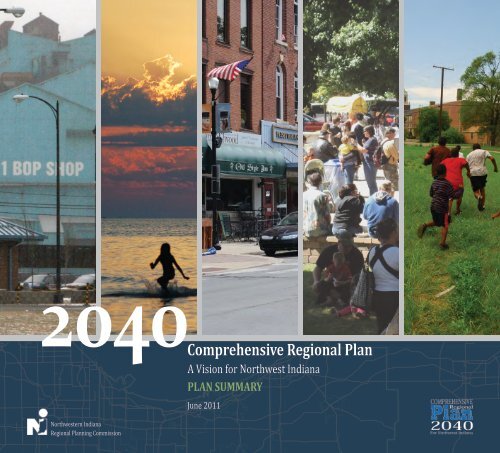
Comprehensive Regional Plan - Northwestern Indiana Regional ...
Comprehensive Regional Plan - Northwestern Indiana Regional ...
Comprehensive Regional Plan - Northwestern Indiana Regional ...

Create successful ePaper yourself
Turn your PDF publications into a flip-book with our unique Google optimized e-Paper software.
2040<strong>Comprehensive</strong><br />
<strong>Regional</strong> <strong>Plan</strong><br />
<strong>Northwestern</strong> <strong>Indiana</strong><br />
<strong>Regional</strong> <strong>Plan</strong>ning Commission<br />
A Vision for Northwest <strong>Indiana</strong><br />
PLAN SUMMARY<br />
June 2011
Jef f er son<br />
ABOUT NIRPC AND THE 2040 COMPREHENSIVE REGIONAL PLAN<br />
Serving Lake, Porter and LaPorte counties, the <strong>Northwestern</strong> <strong>Indiana</strong> <strong>Regional</strong><br />
<strong>Plan</strong>ning Commission is a council of local governments that provides a forum<br />
for Northwest <strong>Indiana</strong> elected officials to address regional issues relating to<br />
transportation, environment and community and economic development. The agency<br />
was established in 1965 as the Lake-Porter County <strong>Regional</strong> Transportation and<br />
<strong>Plan</strong>ning Commission pursuant to enabling legislation enacted by the state. A 1973<br />
amendment provided the commission with its current name and allowed for the<br />
addition of new member counties, resulting in LaPorte County joining NIRPC in 1979.<br />
An amendment in 1996 provided a seat on the commission for every mayor and a<br />
subsequent amendment in 2003 opened seats to all 41 cities and towns in the threecounty<br />
region, with a requirement that representatives be elected officials.<br />
NIRPC operates as a cooperative with 53 members. In addition to the municipal<br />
appointments, the county councils, boards of commissioners, county surveyors and<br />
the governor appoint one member. The agency’s planning area is composed of Lake,<br />
Porter and LaPorte counties, encompasses 1,520 square miles, includes 41 cities and<br />
towns and 44 townships and currently is home to more than 770,000 people.<br />
NIRPC also functions as the Metropolitan <strong>Plan</strong>ning Organization (MPO) for Northwest<br />
<strong>Indiana</strong>. It works with federal and state transportation departments and local transit<br />
operators to prioritize and fund regional transportation projects, making the region<br />
well positioned to capitalize on some of the most strategic and critical links in our<br />
nation’s transportation system.<br />
NIRPC’s adopted purpose is to create the conditions within which policy makers can<br />
create a sustainable, vibrant regional community and quality of life for Northwest<br />
<strong>Indiana</strong>.<br />
The 2040 <strong>Comprehensive</strong> <strong>Regional</strong> <strong>Plan</strong> (CRP) places NIRPC in a new role in the<br />
region with respect to planning and implementation. NIRPC is being called upon to<br />
assist local governments and regional stakeholders to develop integrated land use<br />
and transportation strategies, support economic development efforts, help realize<br />
land conservation and a protected green infrastructure, and to do so in a manner that<br />
recognizes and supports social equity and environmental justice.
White<br />
2040<br />
<strong>Comprehensive</strong><br />
<strong>Regional</strong> <strong>Plan</strong><br />
A Vision for Northwest <strong>Indiana</strong><br />
PLAN SUMMARY<br />
Lagrange<br />
Elkha rt<br />
To view the full 2040 CRP go to www.nirpc.org<br />
Nobl<br />
Marsh all<br />
Kosciusko<br />
Requests for alternate formats, please contact Mary Thorne at NIRPC at (219) 763-6060<br />
extension 131 or at mthorne@nirpc.org. Individuals with hearing impairments may contact us<br />
through the <strong>Indiana</strong> Relay 711 service by calling 711 or (800) 743-3333.<br />
Whitle y<br />
Fulton<br />
Pula ski<br />
The <strong>Northwestern</strong> <strong>Indiana</strong> <strong>Regional</strong> <strong>Plan</strong>ning Commission (NIRPC) prohibits discrimination<br />
in all its programs and activities on the basis of race, color, sex, religion, national origin, age,<br />
disability, marital status, familial status, parental status, sexual orientation, genetic information,<br />
political beliefs, reprisal, or because all or part of an individual’s income is derived from any<br />
public assistance program.<br />
Wa bash<br />
Hunt ing ton<br />
Miami<br />
Cass<br />
<strong>Northwestern</strong> <strong>Indiana</strong> <strong>Regional</strong> <strong>Plan</strong>ning Commission • June 2011<br />
Benton
THE TASK BEFORE US<br />
Nestled in the northwest corner of <strong>Indiana</strong>, between the metropolitan<br />
influences of Chicago and <strong>Indiana</strong>polis, our region has longed for an<br />
opportunity to stand on its own. Shaped by sand and steel, Northwest <strong>Indiana</strong><br />
draws on a rich history of economic accomplishment and unmatched natural<br />
beauty. Today, these advantages present us with a unique challenge in an<br />
unpredictable world – to shape our own future, and sustain our diverse quality<br />
of life.<br />
This challenge has been met with the release of the 2040 <strong>Comprehensive</strong><br />
<strong>Regional</strong> <strong>Plan</strong>, or CRP, which represents the first broad planning initiative<br />
covering Lake, Porter and LaPorte counties. Unlike previous plans released<br />
by NIRPC, which focused primarily on transportation, the CRP marries into<br />
the mix land use, human and economic resources, and environmental policy<br />
objectives.<br />
1<br />
Together, these are extremely broad issues that require complex decision<br />
making on a large, regional scale. While some aspects of the CRP are based on<br />
local plans and near-term improvements, its long-term horizon pushes us to<br />
think well beyond these needs.<br />
The CRP exists as a blueprint of our collective desires to remake Northwest<br />
<strong>Indiana</strong> as a vibrant, revitalized, accessible and united region - and to help all<br />
see and enhance the beauty of where we live and work.<br />
Lake County Courthouse with U.S. Steel<br />
in background, Gary
An Evolving Region<br />
THE CRP STRESSES A NUMBER OF FACTORS THAT POINT TO BOTH OUR<br />
CHANGING DEMOGRAPHICS AND OUR FUTURE OPPORTUNITIES:<br />
Northwest <strong>Indiana</strong> Population<br />
1980<br />
751,413<br />
2010<br />
771,815<br />
2040<br />
941,815<br />
1,000,000<br />
900,000<br />
800,000<br />
700,000<br />
600,000<br />
1950<br />
485,036<br />
500,000<br />
400,000<br />
1920<br />
230,656<br />
300,000<br />
200,000<br />
100,000<br />
2<br />
0<br />
1900 1910 1920 1930 1940 1950 1960 1970 1980 1990 2000 2010 2020 2030 2040<br />
Source: U.S. Census Bureau, Stats <strong>Indiana</strong>, NIRPC Projections<br />
POPULATION AND JOB GROWTH<br />
The Lake, Porter, and LaPorte region expects<br />
to grow by 170,000 people (a 13 percent<br />
increase) and 80,000 new jobs (a 29 percent<br />
increase) by the year 2040. The following<br />
have been identified as the prime sectors for<br />
job growth:<br />
1. Transportation, Distribution and<br />
Logistics<br />
2. Advanced Manufacturing<br />
3. IT and Technology<br />
4. Professional and Medical Services<br />
LIVABLE CENTERS<br />
Northwest <strong>Indiana</strong> will concentrate<br />
population and employment within existing<br />
communities following a “Livable Centers”<br />
principle. 83 percent of the region’s<br />
population and 93 percent of employment<br />
will be situated in livable centers to take<br />
advantage of existing infrastructure, services,<br />
facilities and amenities.<br />
REVITALIZATION<br />
Northwest <strong>Indiana</strong> will focus on<br />
revitalization of the region’s core<br />
communities, which include Gary, Hammond,<br />
East Chicago and Michigan City, to make<br />
efficient use of resources and to capitalize on<br />
existing infrastructure and assets.
3<br />
MULTIMODAL TRANSPORTATION<br />
To encourage livability and accessibility,<br />
Northwest <strong>Indiana</strong> will create a strong multimodal<br />
transit network. This network will<br />
connect the region’s major centers, provide<br />
access to jobs and improve our quality of life<br />
through strategies that increase travel choice<br />
and reduce vehicle congestion.<br />
PARTNERSHIPS<br />
Northwest <strong>Indiana</strong> will utilize the region’s<br />
educational and institutional organizations<br />
for investments in job and capital programs<br />
supportive of the CRP Vision.<br />
ENVIRONMENTAL STEWARDSHIP<br />
Our residents and employers will embrace<br />
our responsibilities as stewards of our<br />
natural resources and will seize opportunities<br />
to build a green infrastructure network.
R<br />
R<br />
R<br />
¬«41<br />
¬«41<br />
Hammond<br />
Munster<br />
Dyer<br />
®q<br />
®q<br />
Hammond<br />
¬«41<br />
Hammond<br />
Dyer<br />
Munster<br />
Dyer<br />
®q<br />
OS<br />
Munster<br />
Whiting<br />
¬«20<br />
OS<br />
Whiting<br />
¬«20<br />
Whiting<br />
¬«20<br />
East Chicago<br />
St. John<br />
Highland<br />
Griffith<br />
Schererville<br />
Cedar Lake<br />
¬«41<br />
Schneider<br />
East Chicago<br />
St. John<br />
East Chicago<br />
St. John<br />
Highland<br />
Schererville<br />
Schererville<br />
BD<br />
Highland<br />
Griffith<br />
Cedar Lake<br />
¬«41<br />
Schneider<br />
BD<br />
¬«41<br />
Schneider<br />
Griffith<br />
Cedar Lake<br />
R<br />
R<br />
OS<br />
Lowell<br />
Lowell<br />
®q<br />
®q<br />
Lake Dalecarlia<br />
Lowell<br />
®q<br />
®q<br />
®q<br />
Lake Dalecarlia<br />
BD<br />
OS<br />
®q<br />
OS<br />
OS<br />
Lake Dalecarlia<br />
OS<br />
BD<br />
OS<br />
OS<br />
¬«2<br />
OS<br />
¬«2<br />
¬«2<br />
¬«55<br />
¬«55<br />
Gary<br />
Merrillville<br />
¬«55<br />
Crown Point<br />
¬«55<br />
Gary<br />
Merrillville<br />
BD<br />
Gary<br />
¬«55<br />
Merrillville<br />
¬«55<br />
¬«55<br />
Crown Point<br />
BD<br />
¬«55<br />
Crown Point<br />
¬«55<br />
R<br />
BD<br />
OS<br />
OS<br />
BD<br />
Lake Michigan<br />
Lake Station<br />
New Chicago<br />
®q<br />
Hobart<br />
¬«51<br />
Red blue yellow green<br />
Winfield<br />
Lakes of the Four Seasons<br />
Lake Michigan<br />
Lake Station<br />
New Chicago<br />
®q<br />
Hobart<br />
New Chicago<br />
®q<br />
R<br />
¬«51<br />
Ogden Dunes<br />
¬«2<br />
Hebron<br />
Portage<br />
¬«8<br />
Dune Acres<br />
Porter<br />
Chesterton<br />
Valparaiso<br />
<strong>Northwestern</strong> <strong>Indiana</strong> <strong>Regional</strong> <strong>Plan</strong>ning Commission<br />
Winfield<br />
Lakes of the Four Seasons<br />
Lake Michigan<br />
OS<br />
Hobart<br />
Winfield<br />
OS<br />
R<br />
Lake Station<br />
¬«51<br />
Ogden Dunes<br />
¬«2<br />
Hebron<br />
Portage<br />
¬«8<br />
Dune Acres<br />
Porter<br />
Chesterton<br />
Valparaiso<br />
<strong>Northwestern</strong> <strong>Indiana</strong> <strong>Regional</strong> <strong>Plan</strong>ning Commission<br />
Lakes of the Four Seasons<br />
BD<br />
OS<br />
BD<br />
OS<br />
R<br />
BD<br />
BD<br />
BD<br />
Ogden Dunes<br />
¬«2<br />
Hebron<br />
OS<br />
BD<br />
BD<br />
R<br />
Portage<br />
R<br />
BD BD<br />
R<br />
OS<br />
BD<br />
BD<br />
BD<br />
¬«8<br />
BD<br />
BD<br />
BD<br />
BD<br />
BD BD<br />
BD<br />
Dune Acres<br />
BD<br />
R R<br />
Porter<br />
BD<br />
BD<br />
Chesterton<br />
Valparaiso<br />
¬«49<br />
¬«12<br />
¬«49<br />
Kouts<br />
¬«12<br />
Kouts<br />
OS BD<br />
OS<br />
BD<br />
¬«12<br />
¬«49<br />
Kouts<br />
Pines<br />
Beverly Shores<br />
¬«2<br />
§¨¦I-90<br />
Westville<br />
Pottawattamie Park<br />
¬«35<br />
Michigan City<br />
Trail Creek<br />
Michiana Shores<br />
Long Beach<br />
®q ®q<br />
Wanatah<br />
Pines<br />
Beverly Shores<br />
¬«2<br />
§¨¦I-90<br />
Westville<br />
La Crosse<br />
®q ®q<br />
R<br />
Beverly Shores<br />
<strong>Northwestern</strong> <strong>Indiana</strong> <strong>Regional</strong> <strong>Plan</strong>ning Commission<br />
OS<br />
OS<br />
R<br />
R<br />
BD<br />
BD<br />
BD<br />
BD<br />
BD<br />
R<br />
BD<br />
OS<br />
R<br />
OS<br />
R<br />
BD<br />
R<br />
R<br />
¬«2<br />
OS<br />
OS<br />
BD<br />
§¨¦I-90<br />
Pines<br />
Westville<br />
Red blue yellow green<br />
®q<br />
¬«2<br />
¬«35<br />
¬«39<br />
®q<br />
La Porte<br />
Kingsbury<br />
Kingsford Heights<br />
0 1<br />
2 4 6 8 10<br />
Miles<br />
Pottawattamie Park<br />
¬«35<br />
Michigan City<br />
Trail Creek<br />
Wanatah<br />
La Crosse<br />
¬«35<br />
Michiana Shores<br />
Long Beach<br />
®q<br />
¬«2<br />
¬«35<br />
¬«39<br />
®q<br />
La Porte<br />
¬«20<br />
Weak Consensus<br />
Medium Consensus<br />
Strong Consensus<br />
Proposed consolidation<br />
into a larger center<br />
Kingsbury<br />
Kingsford Heights<br />
0 1 2 4 6 8 10<br />
Miles<br />
Michigan City<br />
®q ®q<br />
BD<br />
BD<br />
BD<br />
OS<br />
R<br />
OS<br />
R<br />
R<br />
Wanatah<br />
La Crosse<br />
Long Beach<br />
Pottawattamie Park<br />
Trail Creek<br />
BD<br />
BD<br />
BD<br />
Michiana Shores<br />
®q<br />
¬«2<br />
¬«35<br />
BD<br />
¬«39<br />
®q<br />
La Porte<br />
Kingsbury<br />
¬«20<br />
¬«4<br />
¬«6<br />
Metro Large Medium Small<br />
Center Community Community Community<br />
2040 <strong>Comprehensive</strong> <strong>Regional</strong> <strong>Plan</strong><br />
Map produced by <strong>Northwestern</strong> <strong>Indiana</strong> <strong>Regional</strong> <strong>Plan</strong>ning Commission (NIRPC). NIRPC<br />
cannot be held liable for any errors or inaccuracies in the information provided in this map.<br />
¬«4<br />
Expressway<br />
Arterial<br />
Heavy Rail<br />
Light Rail<br />
Bus Rapid Transit<br />
Water<br />
Trails<br />
Kingsford Heights<br />
0 1 2 4 6 8 10<br />
Miles<br />
R<br />
BD<br />
BD<br />
R<br />
R<br />
BD<br />
BD<br />
¬«20<br />
BD<br />
¬«6<br />
Weak Consensus<br />
Medium Consensus<br />
Strong Consensus<br />
Proposed New Road<br />
2040 <strong>Comprehensive</strong> <strong>Regional</strong> <strong>Plan</strong><br />
Map produced by <strong>Northwestern</strong> <strong>Indiana</strong> <strong>Regional</strong> <strong>Plan</strong>ning Commission (NIRPC). NIRPC<br />
cannot be held liable for any errors or inaccuracies in the information provided in this map.<br />
BD<br />
¬«4<br />
¬«6<br />
OS<br />
OS<br />
OS<br />
OS<br />
R<br />
R<br />
BD<br />
R<br />
BD<br />
Agriculture<br />
All Open Space<br />
BD Biodiverse Open Space<br />
OS Other Open Space<br />
R Water Used for Recreation<br />
2040 <strong>Comprehensive</strong> <strong>Regional</strong> <strong>Plan</strong><br />
Map produced by <strong>Northwestern</strong> <strong>Indiana</strong> <strong>Regional</strong> <strong>Plan</strong>ning Commission (NIRPC). NIRPC<br />
cannot be held liable for any errors or inaccuracies in the information provided in this map.<br />
Weak Consensus<br />
Medium Consensus<br />
Strong Consensus<br />
Proposed consolidation<br />
into a larger center<br />
µ<br />
Championing Collaborative Solutions<br />
THE VISION<br />
The 2040 <strong>Plan</strong> is built on a “community-based regional<br />
consensus” - the outcome of numerous public involvement<br />
meetings with residents and decision makers. An overall<br />
direction, conceived at the Forum on the Future of Northwest<br />
<strong>Indiana</strong>, a 500-person visioning event held in December 2008, is<br />
summarized in the vision statement.<br />
INVision Northwest <strong>Indiana</strong> - Stretching from the treasured<br />
shores of Lake Michigan to the historic banks of the Kankakee<br />
River and committed to an ethic of sustainability:<br />
THE FRAMEWORK<br />
Community meetings held throughout the region identified preferences for<br />
centers, corridors and green areas - places to encourage development, key<br />
highway/transit connections and important natural and rural lands.<br />
Creating Tomorrow Today Subregional Cluster Workshops:<br />
Centers Synthesis<br />
¬« 212<br />
¬« 520<br />
§¨¦ ¬« I-94<br />
912 [l<br />
¬« 312 ¬«<br />
§¨¦ 249 ¬« 152 I-90 ¬« 149<br />
¬« 421<br />
§¨¦ §¨¦ §¨¦ I-80 I-94<br />
I-80<br />
¬« 130 ¬«35<br />
¬«30<br />
¬« 421<br />
¬« 231<br />
§¨¦ I-65<br />
¬« 104<br />
Center Types and Levels of Consensus<br />
CENTERS<br />
4<br />
A vibrant region<br />
A revitalized region<br />
µScale 1 : 80,000<br />
Our economy is thriving;<br />
our people are welleducated;<br />
our growth is<br />
planned; and natural and<br />
rural areas are valued and<br />
protected.<br />
Urban areas are renewed,<br />
and our environment is<br />
clean.<br />
Creating Tomorrow Today Subregional Cluster Workshops:<br />
Corridors Synthesis<br />
¬« 212<br />
¬« 520<br />
§¨¦ ¬« I-94<br />
912 [l<br />
¬« 312 ¬«<br />
§¨¦ 249 ¬« 152 I-90 ¬« 149<br />
¬« 421<br />
§¨¦ §¨¦ §¨¦ I-80 I-94<br />
I-80<br />
¬« 130 ¬«35<br />
¬«30<br />
¬« 421<br />
¬« 231<br />
§¨¦ I-65<br />
¬« 104<br />
Corridor Types and Levels of Consensus<br />
CORRIDORS<br />
An accessible region<br />
A united region<br />
µScale 1 : 80,000<br />
Our people are connected<br />
to each other and to<br />
equal opportunities for<br />
working, playing, living<br />
and learning.<br />
Celebrating our diversity,<br />
we work together as a<br />
community across racial,<br />
ethnic, political and<br />
cultural lines for the good<br />
of the region.<br />
Creating Tomorrow Today Subregional Cluster Workshops:<br />
Green Area Synthesis<br />
¬« 212<br />
¬« 520<br />
§¨¦ ¬« I-94<br />
912 [l<br />
¬« 312 ¬«<br />
§¨¦ 249 ¬« 152 I-90 ¬« 149<br />
¬« 421<br />
§¨¦ §¨¦ §¨¦ I-80 I-94<br />
I-80<br />
¬« 130 ¬«35<br />
¬«30<br />
¬« 421<br />
¬« 231<br />
§¨¦ I-65<br />
¬« 104<br />
Green Area Types<br />
GREEN AREAS<br />
The CRP includes goals and objectives based on this vision, which give<br />
further clarity and guidance for the plan’s implementation.<br />
µScale 1 : 80,000
THE PRINCIPLES<br />
SUPPORT URBAN REINVESTMENT<br />
Reinvestment in our historic urban centers is a key principle guiding the CRP.<br />
We understand that the metropolitan region is only as strong as its collective<br />
parts. Strengthening the urban core will lift the entire region and preserve the<br />
cultural and historic assets of Northwest <strong>Indiana</strong>. Stakeholders identified the<br />
need to revitalize thes core communities to achieve regional prosperity by 2040.<br />
ENSURE ENVIRONMENTAL JUSTICE<br />
The investment decisions made as a result of the CRP will affect different<br />
communities in varying ways. Benefits and adverse consequences must<br />
be fairly distributed across all communities, including areas with high<br />
concentrations of low-income and minority populations. Where possible,<br />
adverse consequences should be avoided or greatly reduced. Improving<br />
mobility and access to jobs for the low-income and minority populations was a<br />
key consideration in evaluating growth and investment options.<br />
5<br />
PROTECT NATURAL RESOURCES AND MINIMIZE IMPACTS TO<br />
ENVIRONMENTAL FEATURES AND WATERSHEDS<br />
Northwest <strong>Indiana</strong> contains significant environmental assets and productive,<br />
prime farmland, which provide important economic and quality-of-life benefits.<br />
The CRP conserves the green infrastructure that supports native species,<br />
maintains natural ecological processes, protects air and water resources and<br />
contributes to the health and resiliency of the region.<br />
INTEGRATE TRANSPORTATION AND LAND USE<br />
Transportation and land use growth are traditionally linked. The development<br />
of a multimodal system, including enhanced public mass transit and nonmotorized<br />
transportation, helps to improve mobility, access to jobs and<br />
improved quality of life for all.
Northwest <strong>Indiana</strong><br />
Growth and Revitalization Vision<br />
Northwest <strong>Indiana</strong> Growth and Revitalization Vision<br />
6<br />
Legend<br />
Metro Community<br />
Large Community<br />
Medium Community<br />
Small Community<br />
Focused Revitalization<br />
Growth and Infill<br />
Green Infrastructure<br />
N<br />
<strong>Northwestern</strong> <strong>Indiana</strong> <strong>Regional</strong><br />
<strong>Plan</strong>ning Commission<br />
The Growth and Revitalization Vision synthesizes the centers, corridors and green areas maps and gives physical expression to the Vision Statement,<br />
the plan principles and goals and objectives. It contains the components listed on the following page.
Green Infrastructure –<br />
Northwest <strong>Indiana</strong>’s “green infrastructure” is composed of a complex<br />
array of natural and environmental features. The green infrastructure<br />
concept also includes the vast majority of the region’s agricultural<br />
resources. Maintaining a sustainable green infrastructure network is<br />
highly dependent upon successful implementation of both the urban<br />
and rural growth, and conservation strategies of the CRP.<br />
GROWTH AND REVITALIZATION VISION ELEMENTS<br />
Focused Revitalization –<br />
There was broad consensus in the region that investment in and<br />
revitalization of the region’s core urbanized areas, generally located<br />
along the lakefront, are critical to the long-term stability of our<br />
regional social and economic outlook. Repeatedly, revitalization<br />
and redevelopment of the urban core communities were identified<br />
as a high-priority action step. This focus will demand an equitable<br />
distribution and utilization of the region’s resources.<br />
CENTER TYPES<br />
SYMBOL CENTERS GENERAL CHARACTERISTICS/<br />
DESCRIPTION<br />
Small<br />
• Small rural centers supporting basic living<br />
Community needs- low density residential land uses and<br />
some commercial or retail activities<br />
• Residents depend on nearby medium or<br />
large communities to meet full service needs<br />
i.e. major purchases and health care<br />
Examples: Winfield, Long Beach, La Crosse,<br />
Kingsbury<br />
Medium<br />
Community<br />
Large<br />
Community<br />
Metropolitan<br />
Center<br />
REGIONAL TYPOLOGIES<br />
• Moderate size urban/ suburban community<br />
with retail activities and residential land<br />
uses<br />
• Important destinations primarily for the<br />
people from surrounding communities or<br />
towns<br />
• Does not always function as a full “service<br />
community (ie lacks hospital, full retail<br />
services, employment, etc)<br />
• Impacts traffic and land use patterns at local<br />
and sub-regional level<br />
Examples: Lowell, Dyer, St. John<br />
• More of a free-standing community with<br />
hubs of retail activities and residential land<br />
uses<br />
• Includes nearly a full complement of services<br />
and facilities<br />
• Typically sustains a higher percentage of<br />
employment<br />
• Impacts traffic and land use patterns at local<br />
and sub-regional level<br />
Examples: Merrillville, Portage, Valparaiso,<br />
Hobart<br />
• More urban center for commercial activities,<br />
services, amenities and residential land uses<br />
• Includes major/ unique destinations for<br />
people around the region<br />
• Areas with high density of employment and<br />
population<br />
• Significantly impacts the regional economy,<br />
traffic and land use patterns<br />
Examples: Gary, Hammond<br />
ILLUSTRATIONS<br />
POPULATION<br />
INDICATION<br />
up to 6,000<br />
7,000 - 19,000<br />
20,000 -<br />
70,000<br />
70,000 +<br />
Community Type and Role –<br />
The CRP identifies regional preferences for the<br />
growth, scale and character of the region’s 41<br />
communities. Understanding these preferences<br />
was an important step in understanding local<br />
expectations for change.<br />
Growth and Infill –<br />
The CRP recognizes that the continued or<br />
improved economic health of all the region’s<br />
communities requires continued growth and<br />
investment. Perhaps the greatest emphases of<br />
the CRP are policies aimed at accommodating<br />
new growth and infill development in Livable<br />
Centers. This approach is described in the<br />
Transportation and Growth and Conservation<br />
chapters. Success of the Livable Centers<br />
approach also relies on the CRP’s rural and<br />
unincorporated area policies and Green<br />
Infrastructure network.<br />
7
Initiating Change<br />
A meaningful plan for the future must be set in motion today.<br />
Northwest <strong>Indiana</strong> is challenged with many urgent issues,<br />
which include improving infrastructure where it is needed<br />
most, providing quality of life opportunities for all residents,<br />
and continuing to build momentum and confidence for future<br />
investment. The CRP has set a strong framework for action in<br />
which all residents are highly encouraged to participate. While<br />
NIRPC is a key steward of the plan and its implementation, there<br />
are many partners, agencies and organizations it must engage<br />
with to be successful.<br />
8<br />
IMPLEMENTATION ACTION PLAN<br />
The CRP includes an “Implementation Action<br />
<strong>Plan</strong>” that outlines key activities to be completed.<br />
It identifies the projects NIRPC should assume<br />
a strong leadership role on along with “regional<br />
partnership” agencies and organizations. For<br />
example, the <strong>Regional</strong> Development Authority<br />
(RDA) plays an extremely important role in<br />
the implementation of the Marquette <strong>Plan</strong> for<br />
Lakefront Revitalization, expansion of commuter<br />
rail service, enhancement of the regional trail<br />
network and development of a regional bus<br />
system. These represent historical areas of focus<br />
for NIRPC.<br />
CRP IMPLEMENTATION COMMITTEE<br />
Advancing a proactive agenda for change, NIRPC<br />
formed the CRP Implementation Committee to<br />
help identify, organize and prioritize specific<br />
recommendations from the plan. This new<br />
standing committee will aid regional stakeholders<br />
and other agencies of interest in various<br />
implementation activities as outlined in the CRP.<br />
With the help from this committee, NIRPC staff<br />
and Commission board members, a five-to-10<br />
year constrained implementation program will<br />
be drafted. It will realistically assess and identify<br />
responsibilities NIRPC and its partners can<br />
provide toward measurable implementation of<br />
the plan.
New Roles /<br />
Renewed Commitments<br />
A fresh approach to regional planning as<br />
outlined in the CRP will require NIRPC to<br />
continue the roles it has served historically -<br />
in addition to undertaking new challenges.<br />
POLICY STEWARDSHIP<br />
NIRPC will continue to monitor, develop and support actions that advance the interests of<br />
the CRP. Stewardship includes major issue/technical support, legislative initiatives and<br />
an expanding Council of Governments (COG) role.<br />
9<br />
FUNDING AND<br />
FINANCE<br />
NIRPC has served the region well in the past through securing resources for transportation<br />
and community facilities. Working with its partners and stakeholders, NIRPC will focus on<br />
creating and identifying more resources for CRP implementation, particularly in the areas<br />
of economic development and environmental management.<br />
EDUCATION AND<br />
AWARENESS<br />
NIRPC will develop new outreach and education programs to inform its constituency of<br />
agency initiatives and regional issues. Community planning and development training also<br />
has been identified as a role NIRPC could help fulfill.<br />
LOCAL ASSISTANCE<br />
PROGRAM<br />
Many implementation actions identified in the CRP represent local assistance projects.<br />
Supporting and facilitating local community planning, identifying best practices and<br />
relating CRP policies to local development decisions will be an important element of the<br />
plan’s realization.
“The <strong>Comprehensive</strong> <strong>Regional</strong> <strong>Plan</strong> is the type of innovative, longterm<br />
approach we need to take to ensure that Northwest <strong>Indiana</strong> not<br />
only grows, but thrives. As the CRP makes clear, we must continue<br />
to invest in ourselves – in our infrastructure, our local businesses,<br />
our neighborhoods, our lands – in order to remain competitive in<br />
the future. I applaud NIRPC Chairman Tom McDermott and the<br />
entire Board of Commissioners for advocating this positive vision<br />
for Northwest <strong>Indiana</strong>. Now is the time for our communities to come<br />
together to take action on these ideas and make them a reality.”<br />
- United States Representative Peter J. Visclosky
CHARTING THE COURSE<br />
The 2040 <strong>Comprehensive</strong> <strong>Regional</strong> <strong>Plan</strong> offers Northwest <strong>Indiana</strong> a<br />
well-defined road map toward accomplishing a unified and prosperous<br />
vision. This summary plan provides readers a snapshot of the variety<br />
of challenges that need to be addressed to accomplish this vision.<br />
• Growth and Conservation Pattern<br />
• Transportation<br />
• Environment and Green Infrastructure<br />
• Human and Economic Resources<br />
• Stewardship and Governance<br />
• Implementation<br />
p. 12<br />
p. 34<br />
p. 48<br />
p. 60<br />
p. 66<br />
p. 74<br />
<strong>Indiana</strong> Toll Road and<br />
NICTD Station, East Chicago
Chapter I:<br />
Growth & Conservation<br />
OUR GOALS:<br />
• Livable urban, suburban and rural centers<br />
• Revitalized urban core cities<br />
• Managed growth that protects farmland, environmentally sensitive areas and important<br />
ecosystems<br />
REGIONAL PLANNING AREAS<br />
State of Michigan<br />
State of Illinois<br />
¬« 212<br />
¬« 149<br />
£¤ 20 £¤ 421<br />
¬« 51<br />
¬« 912 £¤ 30<br />
£¤ 41 ¬« £¤ 421<br />
¬«<br />
£¤ 231 ¬« 49 µ<br />
2 3 4<br />
£¤ 35<br />
¬« 2<br />
¬« 249 £¤ 12<br />
¬« 312<br />
¬« 49<br />
¬« 104<br />
¬« 130<br />
£¤ 41<br />
¬« 51<br />
£¤ 6<br />
¬« 2<br />
£¤ 35<br />
¬« 39<br />
LaPorte County<br />
Starke County<br />
0 1 5<br />
Miles<br />
£¤ 35<br />
¬« 39<br />
§¨¦ 80<br />
£¤ §¨¦ 41 90 ¬« 152 ¬« 55<br />
§¨¦ 94<br />
¬« 4<br />
¬« 55 §¨¦ Legend<br />
65<br />
¬« 2<br />
Lake County<br />
Newton County<br />
Porter County<br />
Jasper County<br />
¬« 55 ¬« 8<br />
<strong>Northwestern</strong> <strong>Indiana</strong><br />
<strong>Regional</strong> <strong>Plan</strong>ning " Commission<br />
6100 Southport Rd, Portage, IN<br />
Livable Centers<br />
! Economic Centers<br />
Focused Revitalization Areas<br />
Growth and Infill Area<br />
Green Infrastructure<br />
Water<br />
<strong>Regional</strong> Boundaries<br />
Highway<br />
South Shore Line<br />
St Joseph County<br />
Downtown Chcsterton
2040 CRP Summary / Growth and Conservation<br />
FACING REALITY / GROWTH AND CONSERVATION<br />
While our vision for the future embraces renewal, the fact<br />
remains today that our core urban communities, such as<br />
Gary, Hammond, East Chicago and Michigan City, continue to<br />
lose population and jobs. A historical trend of high vacancy<br />
rates in our core downtown districts continues to hinder<br />
revitalization. An urgent need remains to counter this trend<br />
and spark investor confidence where it once flourished.<br />
10.0%<br />
9.0%<br />
8.0%<br />
7.0%<br />
6.0%<br />
5.0%<br />
4.0%<br />
Growth in Population and Total Housing Units<br />
by Decade 1990-2010<br />
9.4%<br />
4.2% 4.1%<br />
8.4%<br />
People<br />
Total Units<br />
14<br />
Historical growth patterns indicate that, without action,<br />
the unincorporated areas of the region will continue to lose<br />
their rural character and further the spread of unsustainable<br />
sprawl. More than 20 percent of the region’s population<br />
resides in unincorporated areas. In Porter and LaPorte<br />
counties, approximately 40 percent of the population<br />
resides in unincorporated areas. Between 1992 and 2006,<br />
total land developed in the unincorporated areas of the<br />
region grew by 125 percent. Besides this, present trends<br />
forecast that job centers will remain in the urbanized areas<br />
of the region.<br />
3.0%<br />
2.0%<br />
1.0%<br />
0.0%<br />
1980<br />
751,413<br />
1990-2000 2000-2010<br />
2010<br />
771,815<br />
2040<br />
941,815<br />
Unless we are able to keep development close to<br />
our existing population centers, we will continue<br />
to consume valuable natural resources, open<br />
space and agricultural land and further degrade<br />
our quality of life.<br />
1950<br />
485,036<br />
Northwest <strong>Indiana</strong> Population Change<br />
1900 - 2040<br />
1920<br />
230,656
When considering the cost of transportation as part of a<br />
household budget, greater commuting distances between<br />
work and home will further erode housing affordability<br />
in Northwest <strong>Indiana</strong>. Additionally, because much of the<br />
form of this growth is occurring as low density housing (82<br />
percent of the region’s residential areas), we are consuming<br />
land at a much higher rate than the population growth.<br />
15
2040 CRP Summary / Growth and Conservation<br />
URBAN FRAMEWORK STRATEGIES<br />
Shifting the focus of development to established<br />
communities represents the foundation of the<br />
physical element of the CRP. By adopting the<br />
following strategies and concentrating growth<br />
around existing infrastructure, we will be able to<br />
use funds efficiently and aid our communities in<br />
providing a high quality of life.<br />
STRATEGY 1:<br />
REINVEST<br />
Infill Development and Adaptive Reuse<br />
Suburban Retrofit / Sprawl Repair<br />
16<br />
Infill population and employment growth will require<br />
the reuse of previously developed lands for new and<br />
creative projects. Many downtown areas in the region<br />
also have experienced significant infill development in<br />
their revitalization efforts. Similarly, adaptive reuse is<br />
the conversion, update and/or expansion of a building<br />
originally designed for one purpose to a different and<br />
new one.<br />
Prime regional examples of both infill and reuse include:<br />
• U.S. Steel Yard (Gary South Shore RailCats stadium),<br />
downtown Gary<br />
• Dalton Arms Apartments, Fifth Avenue, downtown<br />
Gary<br />
• Towle Theater, downtown Hammond<br />
• Center Street housing development, Whiting<br />
• Franklin Street Art District in Michigan City<br />
• New Town West, downtown Crown Point<br />
Suburban retrofit could be considered on a small- or<br />
large-scale basis. This technique involves reworking<br />
conventional , automobile-oriented areas, like singleuse<br />
housing developments, office parks and shopping<br />
centers, into more walkable/bikeable, mixed-use,<br />
transit-ready urban places.<br />
Valparaiso’s Central Park Plaza represents an<br />
outstanding example of a successful suburban retrofit<br />
that will become a landmark for civic activity for years to<br />
come.
17<br />
Implement the Marquette <strong>Plan</strong><br />
The Marquette <strong>Plan</strong>: The Lakeshore Reinvestment Strategy represents a vanguard initiative for our Lake Michigan<br />
shoreline. The overall goal aims to create a livable lakefront by enhancing its role as a destination and a place that attracts<br />
new residents and investment. A series of “catalytic” projects has been proposed, and several completed, since the plan’s<br />
release in 2005.<br />
Marquette <strong>Plan</strong> projects include:<br />
• Portage Lakefront and Riverwalk<br />
• Gary Marquette Park Lakefront East Master <strong>Plan</strong><br />
• East Chicago North Harbor Redevelopment Initiative<br />
• Hammond Lakes Area Marquette <strong>Plan</strong> Improvement Project
2040 CRP Summary / Growth and Conservation<br />
URBAN FRAMEWORK STRATEGIES<br />
STRATEGY 2:<br />
LINK TRANSPORTATION<br />
AND LAND USE<br />
Transit Oriented Development<br />
<br />
1<br />
<br />
Focal Point<br />
3<br />
7<br />
<br />
residences close to the<br />
<br />
<br />
18<br />
Northwest <strong>Indiana</strong>’s existing transit network<br />
is a regional asset unique to the state of<br />
<strong>Indiana</strong>. The region must capitalize on<br />
these transportation assets by planning<br />
for Transit Oriented Development (TOD)<br />
projects. TODs take advantage of transit<br />
access, which typically attracts riders bound<br />
for work destinations. With a mixed-use<br />
living environment, including services and<br />
jobs within walkable distances from station<br />
areas, residents often can eliminate the need<br />
for unnecessary vehicular trips. The CRP<br />
identifies a regional<br />
transit framework for<br />
a system of transitsupported<br />
centers, !<br />
Downtown Chicago<br />
including TODs around<br />
existing South Shore<br />
commuter stations, !<br />
along the proposed<br />
West Lake Corridor<br />
and at regional bus and !<br />
multimodal hubs.<br />
!<br />
! ! ! ! ! ! !<br />
Hammond<br />
East Chicago<br />
2<br />
1<br />
2<br />
Gary/Chicago Airport<br />
Gary Metro Center<br />
<br />
5<br />
<br />
streets with parking lots<br />
and garages to the rear<br />
4<br />
<br />
Miller<br />
Portage/Ogden Dunes<br />
<br />
3 4<br />
South Shore Line Transit Oriented Development Opportunities<br />
! !!<br />
REDEVELOPMENT OPPORTUNITIES<br />
<br />
<br />
<br />
Dune Park (Chesterton)<br />
Beverly Shores<br />
11th Street (Michigan City)<br />
Carroll Avenue (Michigan City)<br />
5<br />
! !<br />
Hudson Lake<br />
A Grand<br />
<br />
<br />
South Bend Airport<br />
<br />
6<br />
Munster 2010<br />
<strong>Comprehensive</strong> <strong>Plan</strong><br />
Existing South Shore Line TOD<br />
Opportunities
TOD Concept Portage Northside Master <strong>Plan</strong><br />
Example of proposed multi-family residential development<br />
(Langham Court - Goody Clancy<br />
Downtown TOD Gary <strong>Comprehensive</strong> <strong>Plan</strong><br />
Development Character<br />
Transit - Oriented Development Vision<br />
12<br />
CONVERT TO TWO-WAY<br />
4TH AVENUE<br />
CONVERT TO TWO-WAY<br />
5TH AVENUE<br />
WEST 5TH AVENUE APARTMENTS<br />
HISTORIC DISTRICT<br />
METHODIST<br />
HOSPITAL<br />
GRANT STREET<br />
90<br />
ENHANCE<br />
SINGLE-FAMILY<br />
HOMES IN<br />
US STEEL WORKERS<br />
HOUSING DISTRICT<br />
12<br />
20<br />
PUBLIC<br />
SAFETY<br />
BUILDING<br />
LINCOLN STREET<br />
RESIDENTIAL DISTRICT<br />
8TH AVENUE<br />
Concept <strong>Plan</strong><br />
1/4 MILE RADIUS<br />
JACKSON<br />
PARK<br />
INFILL<br />
CITY<br />
MULTI-<br />
GENESIS HALL<br />
FAMILY<br />
CONVENTION<br />
HOMES<br />
CENTER<br />
EXISTING<br />
JEFFERSON<br />
MULTI-FAMILY<br />
ELEMENTARY<br />
HOUSING<br />
EXPAND<br />
INFILL<br />
WEST SIDE<br />
SINGLE-FAMILY<br />
PARK<br />
HOMES<br />
UNION<br />
STATION<br />
GATEWAY<br />
PARK<br />
INFILL<br />
MULTI-FAMILY<br />
HOMES<br />
EXPAND<br />
EAST SIDE<br />
PARK<br />
CONSOLIDATE<br />
+ INFILL<br />
COMMERCIAL<br />
GRAND CALUMET RIVER<br />
DEVELOP<br />
ENTERTAINMENT<br />
DISTRICT<br />
EMERSON VPA<br />
HIGH SCHOOL<br />
INFILL<br />
SINGLE-FAMILY<br />
HOMES<br />
RELOCATE INDUSTRIAL USE<br />
+ CREATE GREENSPACE<br />
9<br />
TENNESSEE STREET<br />
Concept <strong>Plan</strong><br />
01 02 03 04 05 06 07 08<br />
MARTIN LUTHERKING DRIVE<br />
12<br />
20<br />
DUNES HIG<br />
Legend<br />
Sub-Area Boundary<br />
City Boundary<br />
94 Interstate<br />
20 Major Road<br />
Railroad<br />
Potential Road<br />
River<br />
1/4 Mile Radius<br />
RELOCATE INDUSTRIAL<br />
USES + CREATE<br />
RELOCATE INDUSTRIAL<br />
GREENSPACE<br />
USES + CREATE<br />
11TH AVENUE<br />
GREENSPACE<br />
Land Use<br />
Train Station<br />
Single-Family<br />
Industrial<br />
Trail Head<br />
Overlook<br />
Multi-Family<br />
Service<br />
Gateway<br />
Commercial<br />
Institutional<br />
Mixed Use<br />
Parks/<br />
Existing/Green<br />
Open Space<br />
Link Trails<br />
Office<br />
Potential Trails<br />
Green Link<br />
Screening/Buffer<br />
Potential Airport<br />
Expansion<br />
11th Street TOD Concept The North End <strong>Plan</strong> Michigan City<br />
HARRISON STREET<br />
RELOCATE ACTIVE TRACKS<br />
TO ELEVATED “GAS LINE”<br />
+ CREATE TRAIL<br />
BROADWAY<br />
VIRGINIA STREET<br />
CENTRAL AVENUE<br />
19<br />
Figure 13.10: Land-Use Strategy: Sub-Area 6 (Downtown)<br />
Figure 3 | Proposed view down Franklin Street with the TOD development along 11th Street. A large grocer is located across the street from a gym, which is adjacent to the train station.
LaPorte Cou nty<br />
Starke County<br />
2040 CRP Summary / Growth and Conservation<br />
URBAN FRAMEWORK STRATEGIES<br />
STRATEGY 2 (CONTINUED):<br />
LINK TRANSPORTATION AND LAND USE<br />
20<br />
State of Illinois<br />
£¤ 35<br />
§¨¦ 90 ¬« 152 ¬« 312<br />
£¤ 20<br />
¬« 912 §¨¦ 80<br />
¬« ¬« 149<br />
§¨¦ 94<br />
¬« 49 ¬« 2<br />
£¤ 421<br />
¬« 130<br />
¬« 51<br />
¬« 2<br />
£¤ 30<br />
¬« £¤ 421<br />
£¤ 12<br />
¬« 55 ¬«<br />
£¤ 231 ¬« 49<br />
¬« 55 §¨¦ 65<br />
¬« 104<br />
¬« 4<br />
£¤ 6<br />
£¤ 35<br />
¬« 39<br />
Lake Cou nty<br />
New ton Co unty<br />
Porter Count y<br />
Jasper Count y<br />
¬« 55 ¬« 8<br />
Source: Federal Railroad Administration,<br />
National Transportation Atlas Database,<br />
NIRPC.<br />
St Joseph Co unty<br />
µ<br />
Industrial Land Use<br />
Active Rail Lines<br />
Interstate<br />
Major Roads<br />
Miles<br />
0 1 2 3 4 5<br />
Potential<br />
Cargo-Oriented<br />
Development Sites<br />
Freight-Supportive Land Use <strong>Plan</strong>ning<br />
NIRPC is working with its partners in the public and private sectors to identify ways to capitalize on the region’s freight<br />
infrastructure and generate opportunities for substantial economic returns. Significant land tracts are available along<br />
truck and freight lines. Many of these sites are former industrial properties (brownfields) or underutilized land that could<br />
be brought back into more productive use as cargo-oriented development for the benefit of the community and region.
Hammond<br />
Munster<br />
Dyer<br />
Whiting<br />
East Chicago<br />
St. John<br />
Highland<br />
Schererville<br />
Griffith<br />
Cedar Lake<br />
Schneider<br />
Lake Dalecarlia<br />
Lowell<br />
Gary<br />
Merrillville<br />
Crown Point<br />
Lake Michigan<br />
New Chicago<br />
Hobart<br />
Lake Station<br />
Winfield<br />
Lakes of the Four Seasons<br />
Ogden Dunes<br />
Hebron<br />
Portage<br />
Dune Acres<br />
Porter<br />
Chesterton<br />
Valparaiso<br />
Kouts<br />
Beverly Shores<br />
Pines<br />
Westville<br />
Michigan City<br />
Wanatah<br />
La Crosse<br />
Long Beach<br />
Pottawattamie Park<br />
Trail Creek<br />
Michiana Shores<br />
La Porte<br />
Kingsbury<br />
Kingsford Heights<br />
¬«41<br />
Creating Tomorrow Today Subregional Cluster Workshops:<br />
Corridors Synthesis<br />
¬« 212<br />
®q<br />
¬« 520<br />
¬«12<br />
§¨¦ ¬« I-94<br />
912 [l<br />
¬«20<br />
®q<br />
¬« §¨¦ 249 ¬« 152 I-90<br />
¬« 312 ¬« 421<br />
¬«2<br />
®q<br />
§¨¦<br />
§¨¦ I-90<br />
I-94 ®q<br />
¬«55<br />
®q<br />
¬«51<br />
¬«2<br />
¬«35<br />
¬«2<br />
®q<br />
¬«55<br />
¬«41<br />
§¨¦ I-80 ¬«30<br />
¬«55<br />
¬« 149<br />
§¨¦ I-80<br />
¬« 130 ¬«2<br />
¬« 231 ¬«49<br />
§¨¦ I-65<br />
¬«8<br />
¬«35<br />
®q ®q<br />
¬« 421<br />
¬«35<br />
¬«20<br />
¬«4<br />
¬« 104<br />
¬«6<br />
¬«39<br />
Corridor Types and Levels of Consensus<br />
Expressway<br />
Weak Consensus<br />
Arterial<br />
Medium Consensus<br />
Heavy Rail<br />
Strong Consensus<br />
Light Rail<br />
Bus Rapid Transit<br />
Water<br />
Proposed New Road<br />
Trails<br />
Corridor Studies<br />
Weak Consensus<br />
Corridor studies are a key<br />
planning activity undertaken by<br />
NIRPC. Corridor studies usually<br />
coordinate transportation and<br />
land use activities along a major<br />
transportation link, such as a<br />
state highway or transit corridor,<br />
toward the development of a<br />
comprehensive vision for that<br />
proposed corridor.<br />
Medium Consensus<br />
Strong Consensus<br />
<strong>Regional</strong>ly significant multimodal<br />
corridors identified for the 2040 CRP<br />
Proposed consolidation<br />
into a larger center<br />
µScale 1 : 80,000<br />
<strong>Northwestern</strong> <strong>Indiana</strong> <strong>Regional</strong> <strong>Plan</strong>ning Commission<br />
1<br />
0 2 4 6 8 10<br />
Miles<br />
2040 <strong>Comprehensive</strong> <strong>Regional</strong> <strong>Plan</strong><br />
Map produced by <strong>Northwestern</strong> <strong>Indiana</strong> <strong>Regional</strong> <strong>Plan</strong>ning Commission (NIRPC). NIRPC<br />
cannot be held liable for any errors or inaccuracies in the information provided in this map.<br />
21<br />
Figure 14 – US-20 Five-Lane with Two-Way Left Turn Lane<br />
Image from the 2008 NIRPC Porter<br />
County U.S. 12/20 Transportation<br />
Corridor <strong>Plan</strong><br />
The Porter County U.S. 12/20 Transportation Corridor <strong>Plan</strong><br />
A-NIRPC0701.00<br />
Northwest <strong>Indiana</strong> <strong>Regional</strong> <strong>Plan</strong>ning Commission Page 36
2040 CRP Summary / Growth and Conservation<br />
URBAN FRAMEWORK STRATEGIES<br />
STRATEGY 3:<br />
NEW WAYS TO DETERMINE<br />
AND ADDRESS HOUSING<br />
NEEDS<br />
22<br />
A region of livable centers with a vibrant, revitalized<br />
urban core requires a variety of housing to<br />
accommodate its residents.<br />
The range of choices should include housing for people<br />
of all income levels and for people in different phases<br />
of life - including younger and older families, seniors,<br />
singles and empty-nesters. As highlighted in the Livable<br />
Centers strategy, emphasis will be placed on encouraging<br />
the compact and diverse mixing of housing types and<br />
affordability levels near job centers and transit routes.<br />
There are many parts of the region where neighborhoods<br />
are in decline and housing is of poor quality and not<br />
considered affordable. Facilitating the rehabilitation<br />
of neighborhoods and the maintenance of quality and<br />
affordable housing will help to stabilize neighborhoods.<br />
Affordable housing finance tools, including loans, grants,<br />
inclusionary practices and other methods, will be<br />
necessary to realize this objective.<br />
HOPE IV Horace Mann development, Gary<br />
Yellow = Affordable; Blue = Unaffordable<br />
Center for Neighborhood Technology Comparison of Traditional<br />
Affordability Metrics with Housing + Transportation Affordability<br />
Index for Lake and Porter counties
The Growth and Revitalization Vision for Northwest <strong>Indiana</strong> is an overall framework<br />
for the region’s expansion and development pattern. It is based on supporting local<br />
plans while encouraging the formation and strengthening of livable centers, efficient<br />
positioning of infrastructure and limiting development in rural and environmentally<br />
sensitive areas. Land suitability analysis provides a valuable tool to assist the region’s<br />
counties, communities and stakeholders in understanding where development may be<br />
most appropriate.<br />
Factors include the availability of infrastructure and utilities, proximity to preferred<br />
growth and infill areas and the presence of important natural and water resources.<br />
The result is a prioritization and ranking of land, within the context of CRP policy, most<br />
suitable for sustainable development. This will guide local planning activities toward<br />
sound and informed development decisions.<br />
STRATEGY 4:<br />
SMARTER LAND<br />
USE DECISIONS<br />
THROUGH LAND<br />
SUITABILITY<br />
23
2040 CRP Summary / Growth and Conservation<br />
URBAN FRAMEWORK STRATEGIES<br />
STRATEGY 5:<br />
GREEN CITIES<br />
Green Streets<br />
Streets comprise a significant portion of the paved surfaces throughout the region and are a major source of stormwater<br />
drainage, or runoff. A green street is a corridor that is designed with less water-tight or impervious surfaces and more<br />
landscaped and functional green space in order to capture and absorb stormwater.<br />
24<br />
Several common practices for greening streets include:<br />
• Skinny Streets: By reducing the width of the street, the amount of impervious surfaces and stormwater runoff is reduced.<br />
• Bioswales: Vegetated open drainage channels designed to accept water runoff, disperse it and absorb it in the ground.<br />
• Stormwater Capturing Curb Extensions: An excavated area behind a reinforced curb with accommodations for<br />
stormwater and landscaping with appropriate vegetation.<br />
• Permeable Pavement: Paving material that allows rainwater to pass through surface.<br />
• Street Trees: The leaf canopy intercepts, slows and filters rainwater, preventing it from hitting the ground or giving it time<br />
to percolate into the soil.<br />
Trail Creek Re-Use <strong>Plan</strong>, Michigan City
Buffington Harbor<br />
Trail below I-90 at existing underpass<br />
Trail over Grand Calumet River at<br />
existiing railroad bridge. Trail below<br />
I-90 at existing underpasses<br />
Trail below I-90 and railroads at existing<br />
underpass<br />
Miller Woods<br />
Lake Street Beach<br />
Paul H. Douglas Center for<br />
Environmental Education<br />
Pavillion<br />
Marquette Park<br />
Aquatorium<br />
Wells Street Beach<br />
West Beach<br />
Gary-Chicago<br />
Airport<br />
United States Steel Gary Works<br />
90<br />
Union Station<br />
4th<br />
9th<br />
11th<br />
15th<br />
Gibson<br />
Woods<br />
Gary West<br />
Side High<br />
School<br />
Ivanhoe<br />
Nature<br />
Preserve<br />
Brunswick<br />
Park<br />
Downtown<br />
Gary<br />
CSX (Conrail)<br />
Baseball<br />
Stadium<br />
N.W.<br />
CSS & SB<br />
Norfolk Southern (CR/PC/NYC)<br />
CSX (B&O)<br />
Trail below I-65<br />
and ramps at new<br />
underpasses<br />
90<br />
20<br />
12<br />
J-Pit<br />
53<br />
21st<br />
23rd<br />
65<br />
Trail below I-65 at<br />
existing overpass<br />
Seberger<br />
Park<br />
29th<br />
Lake<br />
Etta<br />
94 80<br />
Michigan Central Trail<br />
Outside of<br />
Corridor /<br />
Study Area<br />
Within<br />
Corridor /<br />
Study Area<br />
Existing off-street multi-use trail<br />
Ridge<br />
Gleason<br />
Park<br />
<strong>Indiana</strong><br />
University<br />
Northwest<br />
Three Rivers<br />
Park<br />
Proposed off-street multi-use trail<br />
Proposed on-street multi-use trail<br />
Railroad (Active)<br />
Railroad (Inactive or abandoned)<br />
River<br />
Erie Lackawanna Trail<br />
Liable<br />
Cline<br />
EJ & E<br />
Burr<br />
Clark<br />
Whitcomb<br />
Chase<br />
Taft<br />
Broadway<br />
Dr. M. L. K. Jr.<br />
Norfolk Southern<br />
Colorado<br />
Clay<br />
Grand<br />
Ripley<br />
City of Gary limits<br />
Gary Green Link Corridor boundary<br />
City of Gary Parks<br />
Major trail circulation conflict<br />
47th<br />
Minor trail circulation conflict<br />
53rd<br />
CN (GTW)<br />
Colfax<br />
Grant<br />
Harrison<br />
Oak Savannah Trail<br />
Georgia<br />
Landmark<br />
Interpretive site<br />
Overlook<br />
Canoe launch<br />
25<br />
EJ & E<br />
CSX (NIPSCO)<br />
N O R T H<br />
0mi. 1/4mi. 1/2mi. 1mi. 2mi.<br />
Image from the Gary Green Link plan: a master planned, 30-mile multi-use trail that connects the Lake Michigan shoreline with the<br />
Little Calumet and Grand Calumet rivers.<br />
Link Open Space Fragments<br />
Many Northwest <strong>Indiana</strong> ecosystems have become<br />
fragmented over many years of urban development. Small<br />
pockets of surprisingly high-quality natural areas still<br />
exist, though. The protection and linking of these open<br />
spaces and ecosystems are important for air and water<br />
quality, flood control, wildlife habitat, recreation, scenic<br />
landscapes and an overall improved quality of life. The<br />
CRP recommends linking the remaining fragments of key<br />
open space that exist within the urbanized areas.<br />
Urban Agriculture<br />
A network of urban agricultural practices is emerging in<br />
Northwest <strong>Indiana</strong>. These have proven to be an effective<br />
means of reusing property and strengthening community<br />
bonds. NIRPC is taking the first step in developing a Local<br />
Food Systems Study to foster the development of a local food<br />
economy in the region.
2040 CRP Summary / Growth and Conservation<br />
URBAN FRAMEWORK STRATEGIES<br />
STRATEGY 6:<br />
WORK TOGETHER<br />
26<br />
Provide Technical Assistance to Incorporate the<br />
CRP into Local <strong>Plan</strong>s<br />
The CRP is intended to serve as guidance for<br />
local plans and a means to encourage sound<br />
and informed planning decisions through the<br />
integration of local and regional priorities.<br />
But the recommendations of the CRP are not a<br />
substitute for, and will not supersede, local land-use<br />
planning. Just as local plans guided the development<br />
of the CRP, local contexts and decisions will influence<br />
how these recommendations are implemented.<br />
In 2007, NIRPC<br />
published the<br />
Sensible Tools<br />
Handbook<br />
for <strong>Indiana</strong>, a<br />
guidebook for local<br />
implementation<br />
of sensible growth<br />
principles.<br />
Secure Support from Washington, D.C.<br />
New federal funding streams are being made available<br />
to regions. These include grants for planning and<br />
infrastructure for which NIRPC is eligible to apply.<br />
NIRPC also is in a unique position to provide feedback<br />
to federal representatives. Coordination between<br />
local, regional and federal levels of government is<br />
essential to removing barriers to livable communities.<br />
Breaking ground on runway 12-30 at Gary/Chicago International<br />
Airport
South Shore Lakefront Redevelopment, Gary and East Chicago<br />
Provide Support for <strong>Regional</strong> Initiatives<br />
27<br />
Partner with the RDA: The Northwest <strong>Indiana</strong> <strong>Regional</strong> Development Authority (RDA) is a valuable partner with NIRPC in<br />
implementing infrastructure and reinvestment projects in Northwest <strong>Indiana</strong>. The RDA’s enabling legislation specified four<br />
project priorities, all of which overlap with NIRPC’s planning mission:<br />
• Expansion of the Gary/Chicago International Airport<br />
• Extension of the South Shore commuter rail system<br />
• Creation of a regionalized bus transit system<br />
• Restoration of the Lake Michigan shoreline<br />
Gary/Chicago International Airport Development: Northwest <strong>Indiana</strong>’s largest airport, the Gary/Chicago International<br />
Airport (GCIA), long has been a cornerstone for economic development in the region. The airport has commenced a threephase<br />
capital improvement program. When completed, GCIA will be a major commercial aviation center, similar in size to the<br />
<strong>Indiana</strong>polis International Airport. GCIA also presents opportunities for a multimodal passenger center and as the anchor of a<br />
logistics- and cargo-oriented district.<br />
Gary and Region Investment Project: The Gary and Region Investment Project (GRIP) is a multiyear revitalization initiative<br />
sponsored by The Times Media Co. as part of its One Region, One Vision initiative. This project, which includes technical<br />
assistance from the Metropolitan <strong>Plan</strong>ning Council, aims to bring together local community leaders, regional stakeholders,<br />
national experts and federal representatives to develop an investment strategy for Northwest <strong>Indiana</strong>’s urban core, primarily<br />
northern Lake County. It is seeking consensus around a set of major projects identified in previous plans.
2040 CRP Summary / Growth and Conservation<br />
URBAN FRAMEWORK STRATEGIES<br />
STRATEGY 7:<br />
CREATE LIVABLE CENTERS<br />
Northwest <strong>Indiana</strong>’s Livable Centers<br />
28<br />
The development of “Livable Centers” within<br />
the Growth & Infill areas is fundamental to<br />
achieving the preferred regional strategy for<br />
land use, transportation and environmental<br />
balance in Northwest <strong>Indiana</strong>. Stakeholders<br />
clearly identified the elements of the Livable<br />
Centers concept – walkability, mixed uses, infill<br />
development – as part of the region’s goal-setting<br />
exercise. The region’s potential Livable Centers<br />
are identified in the Growth and Revitalization<br />
Vision and the <strong>Regional</strong> <strong>Plan</strong>ning Areas map.<br />
design<br />
character sketch of new multi-story mixed use buildings. Buildings include ground floor<br />
Downtown retail with office and residential & US uses 20 above. Corridor <strong>Plan</strong>, Burns Harbor<br />
Overall Design<br />
The plan’s layout establishes a<br />
network of streets defining<br />
moderate to small length blocks<br />
with ample on-street parking and<br />
numerous off-street parking<br />
facilities located to the rear and<br />
sides of buildings accessible by<br />
rear allies and a limited number of<br />
mid-block driveways. Primary<br />
vehicular access is located<br />
approximately a quarter mile west<br />
of the US 20 / Highway 149<br />
signalized intersection. This new<br />
north-south street is lined with<br />
multi-story, mixed-use block<br />
buildings with on-street parking to<br />
evoke a main street atmosphere.<br />
A central “town green” is situated<br />
within the heart of the downtown<br />
district adjacent to the main<br />
street. The town green’s location<br />
also affords the opportunity to<br />
preserve and incorporate an<br />
existing stand of mature trees<br />
helping to establish a more<br />
North Harbor Redevelopment Initiative, East Chicago
The intersection of Route 2/ Washington Street is conceived as a portal to, and<br />
extension of, downtown. The concept plan shown below contemplates eventual<br />
redevelopment of the northeast and southwest quadrants with strong streetscape<br />
accents and pedestrian improvements tying the north and south sides of the corridor<br />
together. Decorative obelisks (perhaps styled after the bell tower on the VU campus)<br />
are shown bracketing either side of Washington Street on the north side of the<br />
intersection which, together with the arch-formed railroad bridge, forms a strong<br />
entryway to Downtown.<br />
This intersection should be further landmarked with the highest quality development<br />
including buildings with vertical design elements and strong corner treatments. Salt<br />
Creek and its tributaries are opened up as amenity for the area. Much of the south<br />
side of the corridor east of Route 2 is also reclaimed as open space.<br />
The critical need to landmark the northeast corner as a visual “hook” to downtown<br />
demands that the city work closely with the owners of that site to assure the highest<br />
quality design including a strong architectural corner treatment, sidewalks, and<br />
easements or land dedications for transit-staging and public monuments.<br />
The “triangle” formed by the convergence of Route 2 and Horseprairie Avenue is<br />
the main redevelopment opportunity/priority in the corridor likely requiring some city<br />
facilitation in land assembly and deal structuring. New development in this quadrant<br />
should contain a blend of retail, commercial office and possibly some upper-floor<br />
housing.<br />
Trail Creek Re-Use <strong>Plan</strong>, Michigan City<br />
Livable Centers support existing<br />
communities.<br />
They attract public investment to<br />
encourage a sustainable pattern of<br />
population and employment growth<br />
that maximizes the use of areas already<br />
served by roads and utilities.<br />
Livable Centers are connected.<br />
They promote regional connectivity<br />
and are supportive of public<br />
transportation.<br />
29<br />
Livable Centers are compact.<br />
U.S. 30 Corridor <strong>Plan</strong>, Valparaiso<br />
They support a vibrant mix of uses<br />
within a concentrated, accessible area.<br />
Livable Centers are walkable.<br />
They promote non-motorized<br />
opportunities for pedestrians and<br />
bicyclists and provide convenient and<br />
safe alternatives to driving for local<br />
trips.<br />
The Ind. 49 Lakeshore Gateway Sub-Area <strong>Plan</strong> “Gateway to the <strong>Indiana</strong> Dunes”
2040 CRP Summary / Growth and Conservation<br />
RURAL & UNINCORPORATED FRAMEWORK<br />
Conservation of Northwest <strong>Indiana</strong>’s open lands<br />
is a key organizing principle of the CRP. While the<br />
development of Livable Centers throughout the region<br />
will reduce the need to develop our natural and<br />
working landscapes, this section suggests strategies<br />
to manage these valuable resources as our population<br />
grows.<br />
The vast majority of rural and<br />
unincorporated lands in Northwest<br />
<strong>Indiana</strong> lies in the southern part of<br />
the region within the Kankakee River<br />
Basin.<br />
30<br />
While unincorporated and rural areas do<br />
exist north of these areas, this happens<br />
to be where some of the region’s larger<br />
and faster-growing communities are<br />
located. Of the 41 communities in<br />
the three-county area, 29 are located<br />
within the Lake Michigan watershed.<br />
As discussed in more detail in the<br />
section on Environment and Green<br />
Infrastructure, there are many pristine<br />
environments and natural systems<br />
within the Kankakee River Basin.
Preserving the Region’s Rural Character and Resources<br />
The CRP focuses on the protection of natural resources while<br />
supporting the agricultural and rural economy, as well as<br />
allowing for limited compatible nonfarm development.<br />
REFORM UNINCORPORATED<br />
LAND DIVISION<br />
Undivided agricultural land<br />
All three counties in Northwest <strong>Indiana</strong> allow for the division<br />
of agricultural lands for nonfarm land uses - primarily singlefamily<br />
residential uses. These land divisions do not require<br />
the creation of a subdivision, the dedication of public ways<br />
or the installation of utilities. The lack of control over these<br />
land divisions has the potential for a number of negative<br />
consequences:<br />
• Roadway access issues/conflicts<br />
• Groundwater contamination<br />
• Stream and drainage way obstruction<br />
• Soil erosion<br />
• Unnecessary loss of productive farmland<br />
31<br />
The CRP recommends the creation of a development plan<br />
review process that offers incentives for site planning to<br />
avoid these conflicts. An example of a progressive strategy<br />
would include clustering development away from sensitive<br />
areas of a site.<br />
Typical land division<br />
PROVIDE PLANNING AND<br />
IMPLEMENTATION GUIDANCE<br />
Recommendations for local assistance that would advance<br />
the goals of the CRP include local area plans, corridor<br />
studies, conservation design approaches and agricultural<br />
protection tools.<br />
Land division best practice
2040 CRP Summary / Growth and Conservation<br />
RURAL & UNINCORPORATED FRAMEWORK<br />
DEVELOP OUR LOCAL FOOD<br />
SYSTEMS<br />
Food, like water and shelter, is essential for<br />
sustaining us.<br />
Yet we rarely take time to ask where our food<br />
comes from, how it gets to our tables, and whether<br />
we will be able to feed ourselves next month or<br />
next year, let alone in 2040.<br />
32<br />
An objective of the CRP is to foster the<br />
development of local food systems and a local<br />
food economy. A robust local food system will<br />
enhance our vision of a vibrant and accessible<br />
region, supporting the health of all people and<br />
places. NIRPC currently is conducting a local food<br />
study for the region, which focuses on a number of<br />
critical issues.<br />
European Market, Chesterton
Accessibility of Local Food<br />
The success of our local food<br />
system will depend on creating<br />
efficient ways of getting local<br />
foods from our fields to our<br />
residents. Transporting local<br />
foods to their destination is<br />
one piece of the puzzle. The<br />
other is getting residents to the<br />
distribution centers (groceries,<br />
farmstands, etc.). At this time,<br />
there are limited public transit<br />
options that provide convenient<br />
access to local food.<br />
Accessibility to Groceries<br />
Local Food and Land Use<br />
With more than half of our<br />
region’s land devoted to<br />
agriculture, the CRP targets<br />
managed growth to protect<br />
these areas. There are also many<br />
opportunities to convert vacant<br />
urban properties into a network<br />
of urban farms, creating a direct<br />
link for low-income communities<br />
to access high-quality produce.<br />
33<br />
Local Food and the<br />
Environment<br />
Growing a local food system<br />
in Northwest <strong>Indiana</strong> has the<br />
potential to protect and enhance<br />
our environmental assets. As<br />
such, local food can be a tool to<br />
advocate for the health of the<br />
soil and water resources in our<br />
region.
Chapter II:<br />
Transportation<br />
OUR GOALS:<br />
• A safe and secure transportation system<br />
• Increased mobility, accessibility and transportation options for people and freight<br />
• Adequate transportation funding and efficient use of resources<br />
• A transportation system that supports the health of all people<br />
NICTD Station
2040 CRP Summary / Transportation<br />
FACING REALITY / TRANSPORTATION<br />
The legacy of Northwest <strong>Indiana</strong>’s transportation network<br />
plays a central role in supporting and maintaining the<br />
region’s quality of life. Nearly all modes of transport<br />
exist in our three-county region. A critical element of<br />
our region’s economic success is our ability to move<br />
people and goods in a safe, efficient and effective manner.<br />
However, transportation is inadequately funded and major<br />
infrastructure improvements are needed to attract jobs and<br />
rebuild our core cities.<br />
Beyond these limitations, there are significant opportunities<br />
as well. These include our robust shipping, freight and nonmotorized<br />
networks.<br />
Coupling our transportation strengths with our needs<br />
will be key in providing a solid multimodal network from<br />
which everyone in the region will prosper.<br />
36<br />
Central to other important needs in the CRP is a stronger<br />
emphasis on the provision of a quality transit service.<br />
The system as it stands today has no dedicated local<br />
funding source despite the need of many who are “transit<br />
dependent” because of household income, age or disability.<br />
An expanded and accessible public transit system is critical<br />
in creating a region that is truly vibrant, accessible and<br />
equitable.<br />
2,500,000<br />
2,000,000<br />
1,500,000<br />
1,000,000<br />
500,000<br />
0<br />
Fixed Route Ridership<br />
2002 2003 2004 2005 2006 2007 2008 2009 2010<br />
Michigan City Municipal Coach<br />
East Chicago Transit<br />
City of Valparaiso<br />
RBA/Hammond Transit System<br />
Hammond Transit System<br />
Gary Public Transportation<br />
Corporation
A Multimodal Framework<br />
The intermodal nature of Northwest <strong>Indiana</strong>’s transportation system offers the<br />
greatest long-term benefits to our region. A challenge that the CRP addresses<br />
involves how Livable Centers will take advantage of the region’s vast transportation<br />
options by moving more people from inefficient means of travel, to those modes<br />
that enhance our environment, health and quality of life.<br />
TRANSPORTATION STRATEGIES<br />
ROADWAY NETWORK<br />
Of all the transportation modes in use, by far the most prevalent are our<br />
roadways. Since the end of World War II, our primary means of getting around<br />
has been the automobile. In addition, over the past three decades, trucking<br />
has overtaken railroads as the chief means to ship goods. The result has put an<br />
enormous strain on our existing road network, with increased congestion and<br />
deteriorating infrastructure. In response, community leaders continue to call for<br />
expansion projects – such as widening roads or building new ones – while local<br />
funds dry up for repairing their existing network.<br />
Establish a<br />
Congestion<br />
Management Sub<br />
Committee<br />
Collect Data<br />
Process followed<br />
Development of Congestion<br />
Management Objectives<br />
Identify Area<br />
of Application<br />
Ongoing<br />
Data<br />
Collection<br />
Clearly a new way of thinking must be advocated. The CRP’s emphasis for our<br />
future roadway network is on increased efficiency. Here the direction is not<br />
on expansion, but maintaining and improving our existing roads. A number of<br />
activities are advanced in the CRP to help meet this objective:<br />
Develop<br />
Performance<br />
Measures<br />
Evaluation of<br />
<strong>Comprehensive</strong> <strong>Plan</strong><br />
Scenarios<br />
37<br />
Utilize Congestion Management Strategies<br />
These seek to find means to maximize the use and efficiency of existing<br />
roadway facilities. Common congestion relief practices include: travel demand<br />
management, access management, new multimodal access (such as transit),<br />
Intelligent Transportation Systems (ITS), and a range of other activities.<br />
Institute System<br />
Monitoring <strong>Plan</strong><br />
Identify /Evaluate Strategies<br />
Ongoing<br />
Data<br />
Collection<br />
Ongoing<br />
System<br />
Monitoring<br />
IImprove System Safety<br />
While the CRP has identified a range of safety improvements that could be made<br />
on the network, roadway and railroad grade separations would be a major safety<br />
enhancement in the region. Projects that help reach the goals of the CRP will<br />
score high and eventually be constructed when the funding becomes available.<br />
Incorporate Strategies<br />
into<br />
The RTP and TIP<br />
Implement Selected<br />
Strategies/Manage<br />
System<br />
Reform Project Selection Methodology<br />
Monitor Strategy<br />
Effectiveness<br />
Ongoing<br />
Strategies<br />
Monitoring<br />
Noteworthy is that the project selection criteria now in use by NIRPC likely will<br />
be further refined in future years. These emphasize proximity to livable centers,<br />
revitalization and infill locations and other land-use measures.<br />
Traditional Congestion Management Process Steps
2040 CRP Summary / Transportation<br />
TRANSPORTATION STRATEGIES<br />
PUBLIC TRANSPORTATION<br />
38<br />
Critical to the success of our region is the availability<br />
of transit options.<br />
Simply stated, our current network of public<br />
transportation systems is not sufficient to achieve the<br />
goals set out in the CRP. Many portions of Northwest<br />
<strong>Indiana</strong> are underserved and lack connectivity between<br />
modes, such as train and bus. To make matters worse,<br />
declining federal, state and local funding subsidies, and<br />
the lack of a dedicated local funding source, have resulted<br />
in service cuts that further reduce ridership, and in turn<br />
hamper the quality of life of our residents.<br />
Into this challenging mix new and expanded transit<br />
services must play a critical role to fully realize the 2040<br />
CRP Vision.<br />
Achieving the plan’s vision for Livable Centers will:<br />
• play a key role in supporting the plan’s concepts of the<br />
creation of multimodal Livable Centers (all metro, large<br />
and medium centers).<br />
• provide a significant means of reduction on the reliance<br />
of the automobile and will reduce traffic congestion on<br />
the regional roadway network.<br />
• fulfill a critical role in reaching underserved and<br />
transportation-deprived areas of the region since access<br />
to employment and regional services is essential for all.
The <strong>Regional</strong> Transit Vision for Northwest <strong>Indiana</strong> includes the expansion of fixed<br />
route and demand-response bus services, and the addition of premium transit<br />
services, including commuter rail and high-speed rail. The system seeks to link<br />
Livable Centers and provide access to regional transit and prime destinations such<br />
as the Gary/Chicago International Airport and the region’s core communities.<br />
High-capacity transit services that<br />
support desirable development<br />
patterns, including high-speed rail,<br />
commuter rail and regional bus service.<br />
Supportive fixed route, demand<br />
response and other local transit<br />
services are to be provided.<br />
High-speed rail improvements<br />
completed in the Norfolk‐ Southern<br />
corridor near Lake Michigan, with<br />
both legs of the West Lake Corridor<br />
implemented to extend NICTD (South<br />
Shore) commuter rail service to Lowell<br />
and Valparaiso.<br />
A major regional multimodal transit<br />
hub at the Gary/Chicago International<br />
Airport connecting high-speed and<br />
commuter rail and bus.<br />
An arterial bus rapid transit (BRT)<br />
system in select major corridors.<br />
Six regional bus routes proposed in<br />
the RBA Strategic <strong>Plan</strong> provide the<br />
backbone of a network of services<br />
connecting rail stations and other<br />
activity centers.<br />
39<br />
Funding the Vision<br />
Although a level of regional cooperation exists among the transit providers,<br />
Northwest <strong>Indiana</strong> lacks a comprehensive and independently funded regional<br />
transit agency that serves both the transit‐dependent population and choice riders.<br />
In 2000, Lake County took the historic step of creating the <strong>Regional</strong> Transportation<br />
Authority to begin building a cohesive transit network. Today’s RBA is the result<br />
of those early efforts. However, the need for a dedicated local funding source to<br />
provide predictable capital and operating support for the region’s transit services is<br />
at the top of the CRP transit implementation needs.<br />
New local bus services in areas where<br />
the population density would support<br />
it. This will be critical for connecting<br />
the Livable Centers with each other,<br />
and to the regional employment,<br />
shopping and services centers.<br />
Expanded capacity and increased<br />
coverage for demand-response, or<br />
paratransit services in areas not<br />
served by fixed‐route bus is a critical<br />
component of the regional system,<br />
especially in all of LaPorte and Porter<br />
counties, and in southern Lake County.
2040 CRP Summary / Transportation<br />
TRANSPORTATION STRATEGIES<br />
AVIATION<br />
40<br />
Since the days when Octave Chanute pioneered<br />
aviation science along the <strong>Indiana</strong> Dunes, our region<br />
has remained fascinated with expanding air travel.<br />
Today, the most prominent regional location is the<br />
Gary/Chicago International Airport (GCIA), which will<br />
serve as the Chicago metropolitan region’s third airport.<br />
The GCIA supplies complementary services to the<br />
larger O’Hare and Midway International airports and<br />
provides convenient access to the region’s business and<br />
recreational attractions. Considering its prime location<br />
and modernized facilities, GCIA is well positioned to be a<br />
major economic generator for Northwest <strong>Indiana</strong>.<br />
THE GARY/CHICAGO INTERNATIONAL AIRPORT<br />
STRATEGIC BUSINESS PLAN<br />
Gary/Chicago International Airport Expansion<br />
Improvements are planned for GCIA to gain a stronger<br />
market position in both passenger and freight<br />
enplanements. The repositioning and grade separation of<br />
the CN freight rail line will allow the extension of its primary<br />
runway from 7,000 to 8,900 feet. A parallel initiative in<br />
working with the <strong>Regional</strong> Development Authority, the<br />
city of Gary and the state of <strong>Indiana</strong> is to draw collateral<br />
development, including trucking, rail freight and logistics<br />
businesses, to the airport area and the Port of <strong>Indiana</strong>. GCIA<br />
has been designated as a Foreign Trade Zone and provides<br />
significant economic incentives to investors.<br />
FINAL<br />
EXHIBIT III-15: POTENTIAL AREAS FOR DEVELOPMENT<br />
Images from<br />
Gary/Chicago<br />
International<br />
Airport Strategic<br />
Business <strong>Plan</strong>
Porter County Airport Zone Development Study<br />
The Porter County <strong>Regional</strong> Airport, the city of Valparaiso,<br />
Porter County and the Valparaiso Economic Development<br />
Corp have commissioned a plan that will facilitate<br />
the most appropriate land use, infrastructure and<br />
development initiatives, to further promote and maximize<br />
the economic development potential of a 15-square-mile<br />
area surrounding the Porter County <strong>Regional</strong> Airport.<br />
The outcome of this project will be a plan that will create<br />
policies that guide future development around the airport,<br />
identify key catalyst projects to spur development in the<br />
area and address annexation and funding recommendations.<br />
This plan will address the physical and economic issues<br />
and opportunities at the airport in order for this facility<br />
to development into an intermodal facility. This planning<br />
process is expected to yield detailed recommendations<br />
regarding land use, transportation, additional airport<br />
planning, shovel-ready sites and site development<br />
focusing on transit oriented design. Additionally, the<br />
plan will create strong, clear zoning recommendations<br />
that will implement this vision and policies in the plan.<br />
41<br />
Industrial Hwy<br />
Grade Separation<br />
CSX RR Tracks<br />
“Stockton-2”<br />
To EJ&E Kirk Yard<br />
Chicago Ave<br />
Terminations<br />
Chicago Ave<br />
“Pine Junction”<br />
CN/NS Bridge<br />
Industrial Hwy<br />
Cline Ave<br />
Nipsco<br />
Pwr Station<br />
Whiting Branch<br />
Relocated CN RR Tracks<br />
Exist. CN Line<br />
Norfolk Southern Gary Branch (Sugar Track)<br />
CSX Ft. Wayne Line (Dormant)<br />
30<br />
Overall Program Layout<br />
Gary-Chicago International Airport<br />
The repositioning and grade<br />
separation of the CN freight rail line<br />
will allow the extension of its primary<br />
runway from 7,000 to 8,900 feet.
2040 CRP Summary / Transportation<br />
TRANSPORTATION STRATEGIES<br />
42<br />
FREIGHT TRANSPORTATION<br />
The location of Northwest <strong>Indiana</strong> adjacent Chicago,<br />
and at the southern tip of Lake Michigan has afforded<br />
our region an unparalleled opportunity to expand upon<br />
our robust freight transport systems.<br />
These systems will play a significant role in meeting the<br />
region’s mobility and economic development activities in<br />
the foreseeable future. The focused revitalization areas<br />
of Northwest <strong>Indiana</strong>, as detailed in the CRP, possess<br />
the highest concentrations of freight intensive land uses<br />
and multimodal freight infrastructure. Since these cities<br />
also are struggling with vacant land and brownfields,<br />
redevelopment of these lands for freight‐related uses<br />
represents an enormous opportunity for economic<br />
development. Support of the freight industry is focused on<br />
the following recommendations:<br />
Support Development of Intermodal and Multimodal<br />
Freight Facilities and the Logistics Industry<br />
Encourage<br />
Freight Supportive Land Use <strong>Plan</strong>ning and Zoning<br />
Industrial and freight‐related development has its<br />
place in a livable community if it is the result of<br />
collaborative land use and transportation planning.<br />
Coordination and consensus‐building between public<br />
officials and private sector operators is necessary to<br />
identify the appropriate locations for industrial and<br />
freight‐related development and to develop effective<br />
multimodal links between them. Proactive community<br />
planning and land assembly can identify and resolve<br />
these issues in advance of facility proposals.<br />
Separate Highway‐Rail Grade Crossings<br />
Highway‐rail grade crossings cause significant traffic<br />
congestion and create safety issues. Grade separation<br />
would benefit freight movement for both rail and<br />
truck traffic and would increase efficiency and safety<br />
throughout the transportation system.<br />
As both highways and railways become more congested,<br />
it will become increasingly important to use our<br />
transportation network as efficiently as possible.<br />
Intermodal and multimodal freight facilities, where cargo<br />
is transferred between modes, maximize the efficiency of<br />
each mode of transportation. Increased intermodalism has<br />
the potential to take trucks off the roads, improve highway<br />
safety and reduce the environmental impacts of goods<br />
movement. There is a strong consensus at the local, regional<br />
and state level that the development of multimodal freight<br />
hubs offers the potential for sustained economic growth.
BOCT<br />
NS<br />
State of Illinois<br />
NORTHWEST INDIANA FREIGHT FACILITIES<br />
CSXT<br />
INDIANA HARBOR<br />
£¤41<br />
IHB<br />
NS<br />
kj<br />
NS<br />
EJE<br />
kj<br />
o<br />
IHB<br />
NS<br />
BUFFINGTON<br />
HARBOR<br />
PORT OF INDIANA -<br />
BURNS HARBOR<br />
kj<br />
GARY HARBOR<br />
¬« 39<br />
kj<br />
¬« 149<br />
¬« 2<br />
¬« 51<br />
¬« 2<br />
PORTER COUNTY MUNICIPAL<br />
o<br />
¬« 39<br />
£¤30<br />
£¤<br />
¬« 421<br />
53<br />
GARY/CHICAGO INT'L<br />
¬« 4<br />
¬« 49<br />
¬« 55 £¤6<br />
£¤35<br />
¬« 2<br />
¬« 49<br />
Legend<br />
¬« 55 o Airports<br />
kj Ports<br />
¬« 2<br />
CSXT<br />
EJE<br />
NS<br />
§¨¦ 94<br />
§¨¦ 80<br />
¬« 51 £¤ 421<br />
£¤ 231<br />
§¨¦ 65<br />
CN<br />
Lake County<br />
Newton County<br />
CFE<br />
Porter County<br />
Jasper County<br />
¬« 55 ¬« 8<br />
AMTK<br />
CSXT<br />
Note: The rail lines labeled EJE have been acquired by CN.<br />
NS<br />
CSS<br />
CKIN<br />
0 2 4 8<br />
Miles<br />
CSS<br />
CSXT<br />
NS<br />
LaPorte County<br />
Starke County<br />
!C<br />
Northwest <strong>Indiana</strong> Intermodal Facilities<br />
CN<br />
!C<br />
Other Intermodal Facilities<br />
! Industrial Parks<br />
Extra Heavy Duty Highway<br />
Interstates<br />
U.S. Highways<br />
State Highways<br />
Mainline Railroads<br />
Other Railroads<br />
Industrial Land Use<br />
St Joseph County<br />
E<br />
Improve<br />
the Extra Heavy Duty Truck Route<br />
The Extra Heavy Duty Truck Route<br />
in Northwest <strong>Indiana</strong> is a vital link<br />
in the regional industrial freight<br />
network. These routes run from<br />
Hammond to South Bend with<br />
connections to Michigan. This<br />
network of roads originally was<br />
created to support the steel industry,<br />
but it since has been extended to<br />
serve other industries in the region<br />
and to bridge the gap between<br />
shippers in our region and beyond.<br />
43<br />
Support Rail and Maritime Policies that Encourage Mode Shift and Reduced Truck Volumes<br />
The nation’s freight network is a multimodal system.<br />
Adequate public investment should support all modes,<br />
including rail and maritime. The 2040 CRP supports local,<br />
state and national freight policies that encourage mode<br />
shift and reduce truck volumes. Examples include:<br />
• The Port of <strong>Indiana</strong> has been advocating for “shortsea<br />
shipping” between ports on the Great Lakes.<br />
• An “<strong>Indiana</strong> Coal Corridor” has been proposed, which<br />
would consist of railroads connecting southern<br />
coalmines with northern power plants, mainline<br />
railroads and ports. The corridor would increase<br />
the share of <strong>Indiana</strong> coal used in the state’s power<br />
Pulaski<br />
plants and position the state to increase exports<br />
through its Great Lakes and Ohio River ports.<br />
• The <strong>Indiana</strong> Rail <strong>Plan</strong> recommends developing a<br />
short‐haul intermodal rail corridor between Louisville<br />
and Chicago following the Interstate 65 corridor.<br />
• Funding is needed for the construction of a new lock<br />
at the Soo Locks in Sault St. Marie, Michigan that is<br />
capable of handling larger lake freighters. The health<br />
of Northwest <strong>Indiana</strong>’s industry, primarily steel, is<br />
dependent upon these freighters and their transport of<br />
raw materials through the locks. Failure to expand this<br />
would drive up costs for industry and put additional strain<br />
on the highways and railways of Northwest <strong>Indiana</strong>.
2040 CRP Summary / Transportation<br />
TRANSPORTATION STRATEGIES<br />
NON-MOTORIZED TRANSPORTATION<br />
Beyond the traditional aspects of transportation that<br />
focus on motorized means, an increasing interest in nonmotorized<br />
travel has emerged nationwide. Either due to<br />
obesity and health matters, or a desire to spend less at the<br />
gas pump, people are enjoying a newfound appreciation<br />
of the oldest means of transportation. To this end,<br />
Northwest <strong>Indiana</strong> is becoming a premiere location for<br />
bicycle, pedestrian and water trail travelers.<br />
Northwest<br />
<strong>Indiana</strong> is<br />
becoming<br />
a premiere<br />
location<br />
for bicycle,<br />
pedestrian<br />
and water<br />
trail<br />
travelers.<br />
44<br />
With the adoption of the Northwest<br />
<strong>Indiana</strong> <strong>Regional</strong> Greenways and<br />
Blueways <strong>Plan</strong> in 2007, the adoption<br />
of Complete Streets Guidelines in 2010<br />
and the updated Ped and Pedal <strong>Plan</strong> of<br />
2010, NIRPC and the region’s cities and<br />
towns have committed to connecting the<br />
Northwest <strong>Indiana</strong> communities and the<br />
adjacent states of Illinois and Michigan<br />
with enhanced opportunities for active<br />
recreation and alternative transportation.<br />
The priorities and opportunities in these<br />
plans include off‐ and on‐road facilities,<br />
as well as water trail routes, which in<br />
turn will help create a more accessible<br />
region with a transportation system that<br />
supports the health of its users.<br />
NIRPC seeks to create a non‐motorized<br />
transportation culture in Northwest<br />
<strong>Indiana</strong>. To accomplish this, a number of<br />
policies, strategies and opportunities have<br />
been identified.
Prioritize Trail Development to Establish a <strong>Regional</strong> Network<br />
Twenty-eight potential corridors were identified and categorized. The outcome<br />
is a network of corridors that connect the region’s Livable Centers and major<br />
scenic areas.<br />
Establish a <strong>Regional</strong> Trail Network along Abandoned Rail Corridors<br />
There are several advantages of using railroad rights‐of‐way for bikeway<br />
development. Abandoned railroad rights‐of‐way can stretch through an entire<br />
region and connect several municipalities. For this reason, abandoned railroad<br />
rights‐of‐way should continue to be used to form the backbone of a regional<br />
trail network that connects municipalities and their trail networks with regional<br />
trails, as well as trail facilities outside of the region.<br />
For the first time, the physically navigable water trails for canoes and<br />
kayaks in the region have been identified and mapped out in NIRPC’s<br />
Greenways and Blueways <strong>Plan</strong>.<br />
Partner with Utility Providers to Use<br />
Utility Corridors<br />
Similar to railroad rights-of-way, utility<br />
corridors provide a linear and generally<br />
unobstructed and undeveloped corridor for<br />
trail development. In Northwest <strong>Indiana</strong>,<br />
the Northern <strong>Indiana</strong> Public Service Co.,<br />
or NIPSCO, has been instrumental in the<br />
development of new multi‐use trails, and<br />
additional opportunities should be pursued.<br />
Use Natural Features to Develop<br />
Greenways<br />
Open corridors adjacent to natural features,<br />
such as rivers and streams, provide additional<br />
opportunities to establish contiguous trail<br />
networks. In Northwest <strong>Indiana</strong>, these<br />
opportunities are abundant and provide both<br />
local and regional recreational options.<br />
Develop Water Trails According to the<br />
Greenways and Blueways <strong>Plan</strong><br />
For the first time, the physically navigable<br />
water trails for canoes and kayaks in the<br />
region have been identified and mapped out<br />
in NIRPC’s Greenways and Blueways <strong>Plan</strong>. It<br />
includes 16 new potential routes within the<br />
three-county region.<br />
Prioritize Complete Streets and<br />
Safe Routes to School<br />
As part of the Transportation Improvement<br />
Program and funding process, Complete<br />
Streets and Safe Routes to School will be a<br />
consideration in funding priorities for the<br />
benefit of system expansion and safety.<br />
45
2040 CRP Summary / Transportation<br />
TRANSPORTATION STRATEGIES<br />
46
CAPACITY EXPANSION TRANSPORTATION PROJECTS<br />
In accordance with federal requirements, the<br />
CRP includes a fiscally-constrained list of all<br />
capacity expansion transportation projects<br />
planned for Northwest <strong>Indiana</strong>. New roads<br />
and highway interchanges, added travel lanes,<br />
new transit lines and new transit routes<br />
are categorized as capacity expansion. To<br />
ensure it is fiscally-constrained, the CRP<br />
contains estimates of future funding levels<br />
and includes only those projects for which<br />
sufficient funding has been identified.<br />
The selection of these projects was<br />
accomplished in consultation and cooperation<br />
with local and regional stakeholders using<br />
criteria based on the CRP vision, goals and<br />
objectives. Eligible projects also had to meet two<br />
prerequisites: the project must be compatible<br />
with the adopted Complete Streets Policy, and<br />
it must be recommended by the Congestion<br />
Management Process. The full project<br />
selection criteria are listed in the full CRP.<br />
The projects were segmented by completion<br />
date in order to test their air quality<br />
impacts and ensure compliance with<br />
National Ambient Air Quality Standards.<br />
In addition to funded projects, the CRP<br />
includes an illustrative list of projects. This<br />
list contains major projects that have been<br />
proposed for Northwest <strong>Indiana</strong>, but do<br />
not have a committed funding source.<br />
Projects Complete by 2016<br />
45th Avenue<br />
Lake County<br />
61st Avenue<br />
Hobart<br />
Mississippi Street<br />
Merrillville<br />
Gary Marina Access Phase 2a segment 3<br />
Gary<br />
Vale Park East<br />
Valparaiso<br />
Main Street Extension<br />
Munster/Cook County, IL<br />
SR-2 at I-65<br />
INDOT<br />
US-421 from SR-2 to SR-2<br />
INDOT<br />
SR-49 at CR-400N<br />
INDOT<br />
US-20 Center Turn Lane<br />
INDOT<br />
SR-912 over <strong>Indiana</strong> Harbor Canal<br />
INDOT<br />
Projects Complete by 2020<br />
Gary Marina Access Phase 3<br />
Gary<br />
Springland Avenue<br />
Michigan City<br />
101st Avenue<br />
Merrillville<br />
Projects Complete by 2030<br />
Willowcreek Extension<br />
Porter County<br />
Projects Complete by 2040<br />
Kennedy Avenue<br />
Schererville<br />
Boyd Boulevard Expansion<br />
LaPorte<br />
Division Road<br />
Valparaiso<br />
Economic Development Corridor NE<br />
LaPorte<br />
Illustrative List of Projects<br />
Projects that are not included in the fiscally-constrained conforming plan:<br />
Broadway Rapid Transit<br />
GPTC/Sierra Club<br />
Westlake Commuter Lines<br />
NICTD<br />
Illiana Expressway<br />
INDOT<br />
47
Chapter III:<br />
Environment<br />
and Green Infrastructure<br />
OUR GOALS:<br />
• MANAGED GROWTH THAT PROTECTS FARMLAND, ENVIRONMENTALLY SENSITIVE<br />
AREAS AND IMPORTANT ECOSYSTEMS<br />
• REDUCED FLOODING RISKS AND IMPROVED WATER QUALITY<br />
• IMPROVED AIR QUALITY<br />
• CLEAN LAND<br />
Coffee Creek Watershed Preserve, Chesterton
2040 CRP Summary / Environment and Green Infrastructure<br />
FACING REALITY / ENVIRONMENT AND GREEN INFRASTRUCTURE<br />
From the majestic <strong>Indiana</strong> Dunes to<br />
the banks of the Kankakee River, the<br />
ecological treasures of the region are<br />
some of our greatest assets.<br />
50<br />
The prime agricultural land, plentiful<br />
waterways and natural areas support the<br />
quality of life and economies of all of our<br />
communities. However, Northwest <strong>Indiana</strong><br />
land consumption over the past 20 years<br />
from urban uses increased dramatically,<br />
whereas population change over the same<br />
period increased very little in comparison.<br />
Many of the region’s agricultural areas,<br />
with limited public structures and service<br />
capacities for residents, have received this<br />
growth. This urban expansion has included<br />
development on high-quality forested and<br />
environmental-sensitive areas, particularly<br />
in Porter and LaPorte counties.<br />
Our water resources play a vital, lifesustaining<br />
role in both the Lake Michigan<br />
and Kankakee River watersheds.<br />
Unconstrained growth will continue to<br />
adversely impact the quality of water<br />
resources we are dependent on in daily life.<br />
Unchecked growth also threatens our air<br />
quality by spreading out more vehicle<br />
congestion. With these complex challenges<br />
facing our region, it is critical that<br />
recommendations throughout the CRP act<br />
in concert to slow and reverse these trends.
Over the course of many decades, a<br />
number of our waterways have become<br />
impaired because of land-use decisions<br />
and practices with the unfortunate side<br />
effect of contributing to increased runoff<br />
volumes, usually loaded with pollutants.<br />
Urban and agricultural runoff, failing<br />
septic systems and point source<br />
discharges from industry and sewage<br />
treatment plants - all contribute to<br />
poor water quality.<br />
51<br />
Helping to counter these impacts are<br />
new watershed management plans<br />
that aim to restore and protect our<br />
waterways by advocating practices<br />
that prevent or reduce polluted water<br />
runoff.
2040 CRP Summary / Environment and Green Infrastructure<br />
WATER RESOURCES AND CONSUMPTION<br />
52<br />
PROTECT OUR WATER RESOURCES<br />
Adjacent to the largest reserve of fresh water supply in the world, Northwest <strong>Indiana</strong><br />
thrives on the availability of water, and the vital role it plays in the economic,<br />
social and environmental well-being of our region. All aspects of our society<br />
depend heavily on this valuable resource. It provides us with drinking water,<br />
a robust ecosystem, a source of prime economic advantage, and an abundance<br />
of recreational opportunities. Our water resources flow from a wide variety of<br />
outlets, including a significant number of wetlands, lakes and streams throughout<br />
the region. Taken together an appreciation must be fostered for protection<br />
measures that conserve our water resources through sensitive development<br />
practices and increased conservation practices.<br />
Lakes and Streams - The presence of<br />
Lake Michigan dominates our regional<br />
culture like no other natural resource.<br />
A unique mix of industrial, residential<br />
and recreational land uses permeates<br />
the coastline and takes full advantage<br />
of what the lake provides economically<br />
and socially. Inland there are more<br />
than 1,775 miles of streams and 500<br />
lakes and ponds scattered across<br />
the Northwest <strong>Indiana</strong> landscape.<br />
Many of these waters are navigable<br />
for primarily recreational uses, with<br />
several having outstanding fishing<br />
value.<br />
Wetlands - Predating its modern<br />
development, Northwest <strong>Indiana</strong> was<br />
teeming with wetlands. These vital<br />
natural areas serve us in many ways<br />
from floodwater storage to prime fish<br />
and wildlife habitat. Today, roughly a<br />
fifth of these wetlands remain, and they<br />
tend to be smaller and fragmented. A<br />
vast majority have been lost to draining<br />
for agricultural or development<br />
purposes. Even so, wetlands remain<br />
an integral part of our region, with an<br />
immense variety of plant and animal<br />
life. They continue to serve us by<br />
providing flood protection, improving<br />
water quality, and offering a myriad of<br />
recreational opportunities.
Water Withdrawal, Consumption and Supply<br />
Floodplains - Often invisible,<br />
floodplains serve many valuable roles,<br />
including floodwater storage, water<br />
quality protection and groundwater<br />
recharge. Over time, much of the Lake<br />
Michigan watershed natural floodplains<br />
have been converted to residential,<br />
industrial and commercial uses. This<br />
has resulted in hundreds of millions<br />
of dollars spent to rebuild structures<br />
damaged by floods and to construct<br />
levees and other flood control systems<br />
to protect them. Farmland also is<br />
affected by flooding in the Kankakee<br />
River Basin. The solution remains<br />
limited development in floodplains and<br />
restoration where opportunities arise.<br />
Aquifers – Since groundwater supplies<br />
many of our rural residents with<br />
drinking water, it is imperative to keep<br />
these resources clear of contaminants.<br />
Nitrate and pesticides are some of<br />
the common threats, although aquifer<br />
sources remain largely clear of unsafe<br />
levels. Groundwater recharge and<br />
discharge rates need to be monitored to<br />
maintain healthy ecosystems, which in<br />
turn protect habitats for both wildlife<br />
and plants.<br />
Our use of regional water supplies needs careful planning so as not to be<br />
overused, and thus impairing our quality of life. Within the past decade, water<br />
withdrawals have declined because of more efficient use of water in industry<br />
and overall conservation practices. The other end of the equation involves the<br />
amount of water returned to our streams, ditches and aquifers. Data shows<br />
industry and agriculture appear to consume the largest portion of water in our<br />
region, where industry returns more water back into the environment – after<br />
appropriate treatment.<br />
On the public consumption end, the<br />
networks of supply systems are vast<br />
and have a tremendous impact on<br />
development. Water flows through<br />
pipelines that serve all land uses,<br />
and provide a valuable incentive<br />
for businesses and residents to<br />
locate. The supply systems range<br />
from municipal facilities to small<br />
private enterprises. The amount<br />
of water consumed varies greatly<br />
over the three counties, with excess capacity available because of the shifts in<br />
population from older urban areas to new developments. This capacity is not<br />
well distributed regionally and not located where the population is moving<br />
to. Over time, adoption of cost-effective water conservation and efficiency<br />
measures of our utilities are needed to reduce the need for costly capacity<br />
investments without restricting future growth.<br />
Wastewater Treatment<br />
As important as getting water to consumers, it is equally critical to safely<br />
and efficiently dispose of their sewage and wastewater. These public sewer<br />
facilities need to be properly planned for protecting our public health,<br />
and supporting desired development. In older communities in the region,<br />
“combined sewer systems,” which collect rainwater and sewage together,<br />
continue to present challenges. When they overflow, untreated wastewater<br />
flows into our rivers and streams. These systems are now in the process of<br />
being corrected to prevent and control these discharges. Another challenge<br />
in less urbanized areas includes the management and maintenance of private<br />
facilities and septic systems.<br />
53
2040 CRP Summary / Environment and Green Infrastructure<br />
GREEN INFRASTRUCTURE<br />
54<br />
BUILD THE GREEN INFRASTRUCTURE NETWORK<br />
Like “gray infrastructure” such as roads, sewers and power grids,<br />
“green infrastructure” is an invaluable element of a region.<br />
Examples include managed networks of natural lands, parks,<br />
greenways and other open spaces that maintain natural<br />
ecological processes and improve our quality of life. The<br />
foundation of green infrastructure networks is their natural<br />
elements, such as forests, wetlands and rivers, which work<br />
together to sustain the natural environment and our people.<br />
<strong>Plan</strong>ning for these networks should be conducted at all<br />
geographic levels and include the following systems:<br />
<strong>Regional</strong> Open Space<br />
Northwest <strong>Indiana</strong> is renowned for its rich environmental<br />
diversity, thanks in large part to our proximity to Lake<br />
Michigan. The backbone of public and private open<br />
spaces forms the core of the region’s vast ecological<br />
diversity and provides opportunities for our enjoyment<br />
of these resources. There exist today approximately 315<br />
natural or recreational areas within Northwest <strong>Indiana</strong><br />
that are managed by a variety of government and private<br />
entities. Open spaces throughout our region include:<br />
Greenways - Lineal corridors of open space, either wateror<br />
land-based, that provide recreational opportunities<br />
and protect natural ecosystems.<br />
Active Open Space - These include playing fields for<br />
team sports and playgrounds and are largely government<br />
owned and managed.<br />
Passive Open Space - Found primarily in unincorporated<br />
areas of the region that involve hiking trails and large<br />
tracts of land set aside for conservation purposes.<br />
There are many needs for increased open space identified<br />
in the CRP. There are hundreds of acres of land brimming<br />
with a variety of native plants and high-quality habitat<br />
remnants. The <strong>Indiana</strong> Department of Natural Resources<br />
recently performed an analysis that documented open<br />
space access deficiencies in the Lake Michigan watershed,<br />
and the 2010 Ped and Pedal <strong>Plan</strong> outlines a series of<br />
prime corridors for future trail development. A number<br />
of waterways also have been identified for increased<br />
recreational use.
55<br />
Forestlands<br />
An appreciation of the value of<br />
forestlands is evident across the globe.<br />
Forests provide a host of benefits, from<br />
habitats for wildlife, to clean air and<br />
water, to providing a solid aesthetic<br />
value for a community. However, over<br />
the years, the number of forested<br />
acres has decreased dramatically in<br />
Northwest <strong>Indiana</strong>, first by agricultural<br />
practices, and recently by development<br />
pressures. There are also threats from<br />
poor tree quality and damaging insects.<br />
Proactive protection policies, enacted<br />
most especially at the local level, will be<br />
necessary to curb further deterioration of<br />
our regional forests.<br />
Biodiversity and Wildlife Habitat<br />
No other region in the Midwest has been<br />
as greatly impacted by human activity as<br />
Northwest <strong>Indiana</strong>. A tremendous variety<br />
of native plant and wildlife species used<br />
to call our region home. These included<br />
pine-covered dunes, marshland habitats<br />
by the Calumet and Kankakee rivers, and<br />
Oak-Savannah and tall grass prairies.<br />
Today, remnants of these systems are<br />
prevalent at <strong>Indiana</strong> Dunes National<br />
Lakeshore and in scattered pockets<br />
of open space. However, even these<br />
are threatened from outside stresses,<br />
where additional protection policies are<br />
necessary to retain and expand upon<br />
their value to the region.<br />
Prime Agricultural Land<br />
Agricultural and rural lands are key<br />
components in a successful green<br />
infrastructure network, preserving<br />
natural and aesthetic qualities and<br />
enhancing rural community character<br />
and well-being.<br />
There are approximately 530 square<br />
miles of prime farmland in our region,<br />
and today an appreciation of their<br />
preservation value is emerging in our<br />
society.
2040 CRP Summary / Environment and Green Infrastructure<br />
AIR QUALITY<br />
IMPROVE OUR AIR<br />
Clean air is vital to the productivity of people, land and<br />
businesses in Northwest <strong>Indiana</strong>. Poor air quality can<br />
cause a myriad of health problems such as heart disease<br />
and asthma. Our region has struggled with maintaining<br />
healthy air standards because of our industrial legacy<br />
and abundance of vehicular traffic. Over the years, our air<br />
quality has improved dramatically because of significant<br />
investments by local industries and vehicle manufacturers<br />
to reduce pollution to comply with federal and state<br />
regulations.<br />
56<br />
Continued progress is necessary, however, over a<br />
broad spectrum of source contributors. Specifically as<br />
the bigger manufacturers reduce their emissions, the<br />
importance of the impacts caused by individuals becomes<br />
greater.<br />
National Ambient Air Quality Standards<br />
The federal government established the National Ambient<br />
Air Quality Standards (NAAQS) as the primary tool to<br />
measure the amount of six critical air pollutants that are<br />
detrimental to human health. Northwest <strong>Indiana</strong> has<br />
achieved “attainment,” or success in each of these six<br />
areas, with the latest involving fine particulate matter<br />
(2009) and ozone (2010). While this is a cause for<br />
celebration for our region, it is important that we maintain<br />
and continue to strive for improvement in air quality.<br />
Air Toxics<br />
Toxics are monitored and regulated differently than NAAQS<br />
pollutants. These are divided into two major groups –<br />
carcinogenic and noncarcinogenic. Both of these are<br />
measured at five air toxic monitoring sites throughout the<br />
region operated by the <strong>Indiana</strong> Department of Environmental<br />
Management (IDEM). Predictably, these toxics are most<br />
prevalent in urbanized areas.
<strong>Regional</strong> Air Quality Programs<br />
Transportation use, by nature, puts an enormous strain on<br />
our environmental quality. Petroleum-based vehicles cause<br />
widespread air pollution, which greatly increase a number of<br />
health problems for our residents. The Air Quality Programs<br />
currently implemented by NIRPC and local partner agencies<br />
focus primarily on these transportation sources. Other sources,<br />
such as industrial air emissions, are regulated or managed by<br />
IDEM, the U.S. Environmental Protection Agency (EPA) and,<br />
sometimes, local health departments. The following details<br />
these efforts.<br />
AIR QUALITY PUBLIC EDUCATION AND OUTREACH –<br />
NIRPC uses federal funding sources to promote a wide variety of activities and events encouraging clean air actions. The program<br />
is called It Adds Up to Cleaner Air, which reminds residents of a number of steps they can employ to improve air quality. Other<br />
important regional programs include Partners for Clean Air and South Shore Clean Cities. NIRPC’s Gas Can Exchange program is one<br />
of the most successful outreach programs today.<br />
VEHICLE EMISSIONS TESTING, INSPECTION AND MAINTENANCE –<br />
Cars and light-duty trucks can contribute significantly to ozone, and produce air toxins and particulates harmful to our health. To aid<br />
in air quality improvement, IDEM requires emission testing of these vehicles in Lake and Porter counties. Continued testing will be<br />
required to prevent backsliding and to maintain our progress.<br />
57<br />
DIESEL EMISSIONS REDUCTION PROGRAMS –<br />
Apart from automobiles, pollution from diesel engines is a significant concern in Northwest <strong>Indiana</strong>. The familiar black soot from<br />
buses and trucks contaminate our air and is a detriment to public health. However, diesel engines are a durable and economical<br />
source of power and are important to our economic livelihoods. A balance is necessary; and a number of programs and projects are<br />
moving forward to reduce diesel emissions in sensible ways.<br />
IDLE REDUCTION –<br />
A significant strategy in reducing air pollution involves a number of technologies that lessen vehicle idling time. This strategy can<br />
provide a number of benefits toward dramatically reducing emissions of pollutants, reducing noise pollution and improving engine<br />
life. Behavioral change is also a method to achieve idle reduction.<br />
ALTERNATIVE FUELS –<br />
Americans are becoming increasingly concerned about the condition of our nation’s air quality and our dependence on foreign oil.<br />
The good news is that alternative fuels are readily available. Alternative-fuel vehicles (AFVs) are becoming more prevalent and are<br />
configured to accept a variety of fuel mixes to aid in efficiency. The major alternative fuels now in use are ethanol, biodiesel, natural<br />
gas, propane/liquefied petroleum gas and ultra-low sulfur diesel.
2040 CRP Summary / Environment and Green Infrastructure<br />
BROWNFIELDS<br />
58<br />
CLEAN UP BROWNFIELDS<br />
Over the years, pollution-creating industries and<br />
businesses have taken a toll on our environment in<br />
Northwest <strong>Indiana</strong>. When they depart from a location,<br />
they leave behind a potentially contaminated footprint and<br />
thus create a “brownfield.” These sites vary in the level<br />
of pollution present, and there are a number of cleanup,<br />
or remediation, standards that govern these programs.<br />
Some sites may involve only minor remediation, and<br />
costs are minimized and new uses initiated. Other sites<br />
can be classified as full-blown “Superfund” sites by the<br />
EPA, which indicate the worst hazardous waste sites in<br />
the U.S. Superfund sites pose an enormous challenge for<br />
remediation, and they are primarily located in low-income,<br />
urbanized areas. Even the sites that are not contaminated<br />
gain a brownfield “stigma” by mere proximity to<br />
others. The existence of these sites not only hampers a<br />
community’s economic outlook, it also severely affects its<br />
overall well-being.<br />
It is critical to promote programs that aid in the<br />
remediation of brownfield sites to protect our<br />
environmental and economic health.<br />
Many sites in our region today have been successfully<br />
cleaned up and restored back to productive use, however<br />
many more locations remain. A number of programs<br />
exist to help restore brownfields and address the array of<br />
complex issues that are associated with these processes.<br />
These programs exist on the state and federal level and<br />
will need to be employed vigorously in order to revitalize<br />
our region for future infill growth in our established urban<br />
areas.
59<br />
Brownfield Remediation:<br />
The site of the Portage Lakefront and<br />
Riverwalk (above) formerly was used by a steel<br />
corporation as settling ponds for industrial<br />
byproduct and a sewage treatment facility.<br />
Through an innovative partnership among the<br />
City of Portage, the National Park Service, the<br />
<strong>Regional</strong> Development Authority, U.S. Steel and<br />
others, the property was restored and returned<br />
to public use.<br />
Opportunities for brownfield restoration exist<br />
throughout Northwest <strong>Indiana</strong>, but our Focused<br />
Revitalization areas hold the greatest potential.
Chapter IV:<br />
Human and<br />
Economic Resources<br />
OUR GOALS:<br />
• A GLOBALLY COMPETITIVE, DIVERSIFIED ECONOMY THAT PROTECTS AND ENHANCES<br />
OUR NATURAL ENVIRONMENT<br />
• EXPANDED ACCESS TO KNOWLEDGE AND EDUCATIONAL OPPORTUNITIES<br />
Gary South Shore RailCats game at the<br />
U.S. Steel Yard, Gary
2040 CRP Summary / Human and Economic Resources<br />
FACING REALITY / HUMAN AND ECONOMIC RESOURCES<br />
62<br />
A core indicator of a vibrant region is the health of its economic sector.<br />
Northwest <strong>Indiana</strong> competes in the Midwest, the nation and the world to<br />
attract business, industry and economic development opportunities.<br />
A number of quality education institutions are in place to train our work force for<br />
the challenges of the 21st century. As our economy continues to move away from<br />
a manufacturing and goods economy to a services and professional economy,<br />
Northwest <strong>Indiana</strong> must adapt to these changing factors and position ourselves<br />
successfully to compete in an increasingly global marketplace.<br />
Economic revitalization is dependent on Northwest <strong>Indiana</strong>’s business,<br />
government and institutions working together to improve work force skills,<br />
develop desired infrastructure and create reinvestment opportunities in the<br />
region’s core communities. Major partners facilitating progress include the<br />
Northwest <strong>Indiana</strong> <strong>Regional</strong> Development Authority, the Northwest <strong>Indiana</strong><br />
Economic Development District and the Northwest <strong>Indiana</strong> Forum. Taken<br />
together, a strong economic framework is in place, and the challenge to the region<br />
will be to assemble the necessary resources for growth and success.<br />
The 2040 CRP places emphasis on<br />
reinvestment and redevelopment<br />
of the region’s core communities,<br />
particularly focusing on Gary,<br />
Hammond, East Chicago and Michigan<br />
City. Support for the economic health<br />
and vitality for the region’s core<br />
communities was an important theme<br />
throughout the planning process.<br />
JOB GROWTH IN NORTHWEST INDIANA 1980 - 2040 (PROJECTED)<br />
328,770<br />
353,091<br />
279,868<br />
1980 1990 2000 2010 2020 2030 2040
CURRENT CONDITIONS AND NEEDS<br />
To properly analyze our economic conditions and outlook,<br />
we must understand the economic “base” of Northwest<br />
<strong>Indiana</strong>. For more than 100 years, our region has been a<br />
prime location for manufacturing, and this economic legacy<br />
has afforded our residents a solid quality of life and security.<br />
Over the years, however, this sector has lost ground to other<br />
areas such as government, health care and retail tourism.<br />
Even so, manufacturing continues to be the leading sector<br />
in our regional economy in terms of jobs. The challenge for<br />
our future resides in our region’s ability to balance these<br />
jobs with those required to compete in an ever-changing<br />
global economy.<br />
63<br />
Northwest <strong>Indiana</strong>’s position as the eastern gateway<br />
to the global city of Chicago and our historic role as a<br />
transportation and freight corridor offer an abundance of<br />
possibilities to expand our quality job base.<br />
Economic Trends and Employment<br />
Historically, much of the economy of Northwest <strong>Indiana</strong><br />
was built on the steel industry. Although a leader for much<br />
of the last century, restructuring in the industry has meant<br />
fewer jobs, reduced tax revenue and environmental cleanup<br />
challenges. The loss of jobs in a once-dominant industry<br />
corresponded with a rise in those living below the poverty<br />
level, with Lake County having a rate well above the national<br />
average. Our region needs to continue to position itself as<br />
prime location for economic development opportunities<br />
that provide for the creation and retention of quality jobs.<br />
Job creation itself is difficult to predict. Many factors<br />
influence job growth in an area, such as governmental<br />
policies and civic amenities. Taken together, Northwest<br />
<strong>Indiana</strong> has plenty of reasons to be optimistic about future<br />
job growth.
2040 CRP Summary / Human and Economic Resources<br />
ECONOMIC DEVELOPMENT STRATEGIES<br />
ADVANCE OUR TOP<br />
INDUSTRY CLUSTERS<br />
Lagging<br />
Change in Occupational Cluster Concentration in Northwest <strong>Indiana</strong>, 2002–2009<br />
1.8<br />
1.6<br />
Skilled Production Workers:<br />
Technicians, Operators, Trades,<br />
Installers, and Repairers<br />
Mature<br />
1.4<br />
64<br />
In order to properly gauge how our economy<br />
can compete, an evaluation of our economic<br />
“clusters” is necessary. These clusters are<br />
types of economic specializations that in<br />
combination offer a competitive advantage<br />
in the marketplaces. A number of potential<br />
clusters have emerged in Northwest <strong>Indiana</strong>.<br />
They include:<br />
• Transportation, Distribution and<br />
Logistics<br />
• Advanced Manufacturing<br />
• IT/Technology<br />
• Professional and Medical Services<br />
Note: The size of each bubble is based on the<br />
number of workers within each occupation<br />
cluster<br />
Source: Center for Workforce Innovations<br />
Northwest <strong>Indiana</strong> 2010 State of the<br />
Workforce Report.<br />
National Location Quotient, 2009<br />
Fading<br />
Public Safety and<br />
Domestic Security<br />
Arts, Entertainment, Publishing,<br />
and Broadcasting<br />
Information Technology<br />
Health Care and Medical Science<br />
(Therapy, Counseling, Nursing, and Rehabilitation)<br />
Legal and Financial<br />
Services and Real Estate<br />
Mathematics, Statistics,<br />
Data, and Accounting<br />
Managerial, Sales, Marketing,<br />
and Human Resources<br />
Natural Sciences<br />
and Environmental<br />
Management<br />
1.2<br />
1.0<br />
0.8<br />
0.6<br />
0.4<br />
0.2<br />
0<br />
Health Care and Medical Science<br />
(Medical Technicians)<br />
Personal Services Occupations<br />
Health Care and Medical Science<br />
(Medical Practitioners and Scientists)<br />
Building, Landscape, and<br />
Construction Design<br />
Agribusiness and Food Technology<br />
Engineering and<br />
Related Sciences<br />
Rising Stars<br />
–9% –7% –5% –3% –1% 1% 3% 5% 7%<br />
At the same time, these are the clusters most in need of strategies<br />
to compete in the global economy.<br />
Within each broad category, the individual Occupation Clusters<br />
can be further broken down into groups that are highly concentrated<br />
(an LQ of 1.2 or greater), lightly concentrated (between<br />
1.0 and 1.19), diffuse (less than 1.0 but greater than 0.8), or weak<br />
(less than or equal to 0.8). The highly concentrated clusters for<br />
Northwest <strong>Indiana</strong>, Skilled Production Workers and Health Care<br />
and Medical Science (Medical Technicians), are areas of strength<br />
for the Region. These are the clusters that are driving the regional<br />
economy and should be marketed to businesses that rely on<br />
these workers.<br />
The lightly concentrated clusters, Personal Service Workers, Health<br />
Care and Medical Science (Therapy, Counseling, Nursing, and<br />
Percentage Change in National Location Quotient, 2002–2009<br />
Sources: Purdue University Center for <strong>Regional</strong> Development; EMSI Covered Employment—1st Quarter 2010<br />
Note: The size of each bubble is based on the number of workers within each occupation cluster<br />
Rehabilitation), and Public Safety and Domestic Security, are also<br />
areas of strength for the Region, but more work needs to be done to<br />
convert them into highly concentrated workers. These are the clusters<br />
that need to make the leap from good to great so the economy<br />
can move forward.<br />
Diffuse and weak clusters need strategies to mitigate the Region’s<br />
deficiencies in these areas. Particularly disturbing are the collection<br />
of Fading clusters. These clusters are sources of high-wage jobs<br />
and are essential to innovation and regional competitiveness. The<br />
skills of workers found in management, mathematics, and information<br />
technology clusters are commonly cited as requirements<br />
by businesses that contribute to a truly competitive economy.<br />
<strong>Regional</strong> innovation and competitiveness in the global economy<br />
are threatened as long as these Occupation Clusters remain in the<br />
Fading category.<br />
42 www.innovativeworkforce.com 2010
LEVERAGE LAND USE<br />
& MULTIMODAL<br />
TRANSPORTATION<br />
NIRPC’s regional role in transportation,<br />
environmental and land use resource<br />
guidance means it is well positioned<br />
to continue to attract state and federal<br />
resources that can be leveraged in the<br />
interest of economic development.<br />
Capitalize on freight assets<br />
Northwest <strong>Indiana</strong> lies at the center of a<br />
global multimodal freight network. This<br />
keeps business costs low and consumer<br />
prices down. The movement, handling<br />
and storing of freight also generates<br />
significant employment. Capitalizing on<br />
our infrastructure advantages to create<br />
economic opportunities is a key strategy<br />
for revitalizing Northwest <strong>Indiana</strong>.<br />
Assess economic impacts of planning<br />
NIRPC should routinely assess and<br />
identify economic impacts of its<br />
transportation planning process and<br />
selection of projects.<br />
Provide land assembly assistance<br />
NIRPC will continue to partner with<br />
the Northwest <strong>Indiana</strong> Forum to create<br />
a stronger understanding of the value<br />
of land assembly in the region. Both<br />
agencies will work together to develop<br />
educational seminars and programs.<br />
SUPPORT THE<br />
NWI ECONOMIC<br />
DEVELOPMENT DISTRICT<br />
The NWI Economic Development District<br />
(NWIEDD) is a partnership between<br />
NIRPC and the Forum that is becoming a<br />
central avenue responsible for regional<br />
economic development. The NWIEDD<br />
serves as a state coordinator and<br />
clearinghouse for regional economic<br />
development grant requests. With<br />
NIRPC’s input and support, the district<br />
is responsible for the preparation and<br />
upkeep of the <strong>Comprehensive</strong> Economic<br />
Development Strategy (CEDS) document.<br />
NIRPC will continue to provide planning<br />
and programming of infrastructure<br />
for economic development and supply<br />
assistance and support to the NWIEDD.<br />
SUPPORT EDUCATION<br />
& JOB DEVELOPMENT<br />
PARTNERS<br />
A vibrant region means our economy<br />
is thriving and our people are well<br />
educated, and a well-educated<br />
population calls for expanded access<br />
to knowledge and opportunities.<br />
Unfortunately many of our schools,<br />
especially in our older urban areas,<br />
suffer from poor results, low graduation<br />
rates and unequal funding. Many<br />
have commented that our region is<br />
undereducated and underprepared for<br />
jobs.<br />
The availability of an educated work<br />
force is a major factor that firms review<br />
as they seek to relocate to a particular<br />
region. Our institutions of education<br />
must improve to help us compete for<br />
quality jobs that sustain our region<br />
and quality of life. We boast several<br />
colleges and universities that aid in our<br />
competitiveness, but without quality jobs<br />
available for graduates, our region will<br />
continue to experience the “brain drain”<br />
that hampers our ability to succeed.<br />
While education in and of itself is not<br />
a core function of NIRPC’s mission,<br />
NIRPC will continue to support and<br />
partner with other agencies that focus<br />
on improved scholastic performance in<br />
Northwest <strong>Indiana</strong>.<br />
65
Chapter V:<br />
Stewardship & Governance<br />
OUR GOALS:<br />
• ENVIRONMENTAL JUSTICE: SHARED BENEFITS AND BURDENS<br />
• EFFICIENT AND COORDINATED LOCAL GOVERNMENT<br />
Porter County Courthouse, Valparaiso
2040 CRP Summary / Stewardship and Governance<br />
FACING REALITY / STEWARDSHIP AND GOVERNANCE<br />
Land use decisions clearly remain the responsibility of local<br />
government. Yet local plans, codes and regulations are essential tools<br />
for accomplishing the regional vision outlined in the <strong>Comprehensive</strong><br />
<strong>Regional</strong> <strong>Plan</strong>.<br />
68<br />
The CRP is intended to serve as advice and support for local plans and<br />
a means to accomplish regionally beneficial planning decisions. NIRPC<br />
will offer technical assistance for local entities, which will be dependent<br />
on community needs and means. NIRPC, as the metropolitan planning<br />
organization (MPO) and council of governments, is uniquely positioned to<br />
guide regional decision-making toward realizing the vision set forth in the<br />
CRP.<br />
As appropriate, NIRPC will continue to take the lead on the following roles of<br />
regional governance and stewardship:<br />
• <strong>Plan</strong>ning, Reviewing and Coordination –<br />
NIRPC can serve an important role in reviewing and/or supporting local<br />
planning initiatives.<br />
• Funding and Finance Support –<br />
NIRPC allocates federal and state funding and can coordinate efforts to<br />
provide shared services and cooperative programs.<br />
• Advocacy and Environmental Justice –<br />
NIRPC will partner with established urban stakeholder groups to address<br />
an equitable distribution of funding and to promote effective policies.<br />
• Education and Communication –<br />
NIRPC can take the lead in facilitating and promoting policies to public<br />
and private groups on a wide range of progressive planning efforts.
69<br />
Legend:<br />
NIRPC Committee<br />
Partner-Tech Support<br />
Partner-Policy, Advocacy<br />
Partner-Funding<br />
*This committee or agency<br />
addresses more than one<br />
Vision Theme<br />
Note: Other NIRPC<br />
Committees include Local<br />
Government Assistance,<br />
Finance and Personnel and<br />
Homeland Security
2040 CRP Summary / Stewardship and Governance<br />
CURRENT STEWARDSHIP CHALLENGES<br />
70<br />
CULTIVATING PARTNERSHIPS<br />
Partnerships, both existing and new, represent the<br />
foundation of regional cooperation and sound stewardship<br />
of our resources. Governments in Northwest <strong>Indiana</strong><br />
largely have remained fractured with multiple units<br />
providing services. A strong voice has emerged from<br />
region residents who desire more cooperation between<br />
municipal units of government, which in turn will help us<br />
achieve cost savings, improved social justice and effective<br />
land management.<br />
Partners in Growth and Conservation<br />
Land Use Committee (NIRPC)<br />
Local Governments<br />
Partners in Transportation<br />
Transportation Policy Committee (NIRPC)<br />
Ped, Pedal and Paddle Subcommittee (NIRPC)<br />
<strong>Regional</strong> Bus Authority<br />
Northwest <strong>Indiana</strong> Commuter Transportation District<br />
<strong>Indiana</strong> Department of Transportation<br />
Federal Highway Administration<br />
Federal Transit Administration<br />
Partners in Environment/Open Space<br />
Environmental Management Policy Committee (NIRPC)<br />
<strong>Indiana</strong> Dunes National Lakeshore<br />
South Shore Clean Cities<br />
Northwest <strong>Indiana</strong> Forum<br />
U.S. Environmental Protection Agency<br />
Little Calumet River Basin Development and Kankakee<br />
River Basin Commission<br />
Environmental Organizations (nonprofits)<br />
<strong>Indiana</strong> Department of Environmental Management<br />
<strong>Indiana</strong> Department of Natural Resources<br />
IL-IN Sea Grant<br />
Industries<br />
These partnerships are harnessed through a variety<br />
of standing committees and entities that interact with<br />
NIRPC on a regular basis. All regional decision-making<br />
stakeholders play a particular role in each of these<br />
committees. The following outlines the committee and<br />
entity structures in relation to the CRP vision:<br />
Partners in Human/Economic Development<br />
Resources<br />
Northwest <strong>Indiana</strong> Forum<br />
Northwest <strong>Indiana</strong> Economic Development District<br />
<strong>Indiana</strong> Economic Development Corp.<br />
Northwest <strong>Indiana</strong> <strong>Regional</strong> Development Authority<br />
Northwest <strong>Indiana</strong> Small Business Development Center<br />
<strong>Regional</strong> Development Company<br />
Construction Advancement Foundation<br />
Northwest <strong>Indiana</strong> Workforce Board<br />
Office of Community and Rural Affairs<br />
Partners in Legislative Advocacy<br />
Legislative Policy Advisory Committee (NIRPC)<br />
Council of Towns and Smaller Cities (NIRPC)<br />
<strong>Regional</strong> Mayors Roundtable (NIRPC)<br />
<strong>Indiana</strong> Association of Cities and Towns<br />
Association of <strong>Indiana</strong> Counties<br />
American <strong>Plan</strong>ning Association – <strong>Indiana</strong> Chapter<br />
Partners in Environmental Justice<br />
Race Relations Council<br />
Northwest <strong>Indiana</strong> Urban League<br />
Northwest <strong>Indiana</strong> Quality of Life Council Inc.<br />
Northwest <strong>Indiana</strong> Federation
CURRENT INITIATIVES<br />
A number of current and ongoing activities are active<br />
in the region encouraging coordination, the practice of<br />
collaboration and the facilitation of stakeholders. NIRPC<br />
supports these efforts in a number of ways. These include<br />
study circles focused on race relations, shared service and<br />
funding assistance, cooperative agreements, information<br />
sharing and the staffing of the Local Government Assistance<br />
Advisory Committee.<br />
Fostering New Partnerships and Initiatives<br />
Building on established relationships, NIRPC should foster<br />
new forms of cooperation. There are a number of untapped<br />
partnerships that are ripe with opportunities. They include:<br />
71<br />
• Colleges and Universities – resources can be shared<br />
where NIRPC lacks staff support<br />
• Developers – promoting sustainable practices with the<br />
help of municipal governments<br />
• Social/Environmental Justice Partners – these must be<br />
integrated into regional policy<br />
Several key initiatives also could be undertaken by NIRPC<br />
that would further help governmental efficiency and<br />
promote dialogue between decision-makers. These include<br />
a regular convening of local officials in Northwest <strong>Indiana</strong>,<br />
establishing task forces addressing important policy areas,<br />
working across state lines with our neighboring entities and<br />
participating in ongoing regional initiatives.<br />
Downtown Valparaiso
2040 CRP Summary / Stewardship and Governance<br />
CURRENT STEWARDSHIP CHALLENGES<br />
A RENEWED COMMITMENT TO ENVIRONMENTAL JUSTICE<br />
Since 1994, every federal agency has been directed to make<br />
“environmental justice” (EJ) part of its mission by addressing<br />
the effects of all programs, policies and activities on “minority<br />
populations and low-income populations.” The goal is to<br />
provide these populations with greater opportunity for public<br />
participation by promoting nondiscrimination in federal<br />
programs.<br />
NIRPC has an obligation to fulfill EJ requirements through<br />
its transportation activities. This commitment translates<br />
on reducing regional patterns of inequity over time and<br />
supporting revitalization efforts in areas of economic<br />
challenge.<br />
72<br />
NIRPC developed the<br />
Environmental Justice Base<br />
Map to identify the areas in<br />
Northwest <strong>Indiana</strong> with higher<br />
than average concentrations<br />
of minority and low-income<br />
populations and to analyze the<br />
impacts of the 2040 CRP.
2040 CRP ENVIRONMENTAL JUSTICE IMPACTS<br />
Inputs:<br />
Population, Households,<br />
Employment,<br />
Transportation Network<br />
Travel Demand Model<br />
Outputs:<br />
Trips by<br />
Purpose and mode,<br />
Travel Time by mode<br />
Implementation of the 2040<br />
CRP framework of Livable<br />
Centers, with an urban<br />
strategy of supporting core<br />
communities, will ensure<br />
access to opportunity for<br />
minority and low-income<br />
people and the maximum<br />
benefit of public expenditures.<br />
73<br />
In these charts, the category<br />
labeled 2010 Existing refers<br />
to current conditions, the<br />
category labeled 2040<br />
Constrained refers to the<br />
conditions in Northwest<br />
<strong>Indiana</strong> in the year 2040 if the<br />
CRP-funded transportation<br />
projects are built and the<br />
category labeled 2040<br />
Unconstrained refers to the<br />
conditions in the year 2040<br />
if both the CRP-funded and<br />
the unfunded, illustrative<br />
projects listed in the plan are<br />
implemented.
Chapter VI:<br />
Implementation<br />
A Pathway to Success<br />
Oak Savannah Bicycle Trail, Hobart
2040 CRP Summary / Implementation<br />
IMPLEMENTATION / A PATHWAY TO SUCCESS<br />
As described briefly in the beginning of this summary, NIRPC’s role in Northwest<br />
<strong>Indiana</strong> has changed dramatically. There has been a clear call by the residents<br />
and stakeholders of Northwest <strong>Indiana</strong> to improve the quality of life in ways only<br />
an organization such as NIRPC is uniquely positioned to do. This summary plan<br />
has offered insights to the many projects and initiatives identified in the complete<br />
<strong>Comprehensive</strong> <strong>Regional</strong> <strong>Plan</strong>.<br />
76<br />
Little Calumet River
While the implementation section of the complete<br />
CRP clearly identifies the many projects, initiatives and<br />
programs recommended to implement the vision, there<br />
are two major aspects critical to the success of the<br />
program briefly discussed below.<br />
NIRPC AS A FULL-SERVICE<br />
REGIONAL AGENCY<br />
THE IMPLEMENTATION COMMITTEE<br />
AND REGIONAL COMMUNITY<br />
The CRP calls for NIRPC to become involved in a<br />
range of implementation activities such as Livable<br />
Centers, a regional vision for transit, core community<br />
revitalization, regional planning and implementation,<br />
education and many others.<br />
These roles could be quite varied from project lead to a<br />
coordinating or supporting role. The fact is execution of the<br />
CRP will require expanding NIRPC’s role. This is a positive<br />
outcome for Northwest <strong>Indiana</strong>.<br />
Stronger working relationships with all its partners and<br />
deeper insights into regional issues and opportunities<br />
will enable NIRPC to effectively respond to needs and<br />
accomplish its goals. These working relationships will help<br />
better identify priorities, give timely access to resources,<br />
and coordination with state, federal and other agencies.<br />
Solid working relationships also will develop trust, mutual<br />
support for common goals and interests, and success.<br />
We know this will take time, and it will be based on the<br />
implementation and action priorities ultimately set by<br />
the NIRPC board. However, implementation will be most<br />
successful when true collaborative relationships are formed<br />
by those committed to addressing the region’s needs.<br />
While the CRP prescribes many implementation actions in<br />
the plan, the actions must be prioritized and programmed.<br />
The newly formed Implementation Committee, working<br />
with the regional community, will undertake the important<br />
task of helping to identify regional priorities, agencies, roles<br />
and funding. While the ultimate authority to approve and<br />
implement a program on behalf of NIRPC will rest with its<br />
board, it is through collaboration with other stakeholders<br />
serving on the committee that will make it work.<br />
To keep momentum and the promise of the CRP vision<br />
moving forward, the creation of a five- and 10-year priority<br />
implementation agenda is necessary. The agenda will be<br />
framed within a well-defined funding program and detail<br />
the means by which project and priority initiatives will be<br />
completed. The agenda will be updated and modified as<br />
required to respond to conditions and opportunities as they<br />
arise, but it will be a prime measure for CRP progress through<br />
the years.<br />
In the end, it is up to the regional community, not<br />
just NIRPC, to implement the CRP. However, NIRPC<br />
understands its role in regional and local consensus<br />
building, and a strong and focused Implementation<br />
Committee will help realize long-term success.<br />
77
OUR FUTURE AWAITS<br />
“Let’s commit ourselves today to the shared task that lies before us.”<br />
~ Bishop Dale J. Melczek, Catholic Diocese of Gary<br />
On a cold, snow-driven December day in 2008, more than 500 people, from all<br />
walks of life, gathered in Merrillville to begin the process of charting our future.<br />
Never before was there an effort to comprehensively plan for all three <strong>Indiana</strong><br />
counties sharing the Lake Michigan shoreline. From this meeting, to numerous<br />
public gatherings, a course has been set to direct our planning, policies and<br />
investments well into the 21st century.<br />
NIRPC’s 2040 <strong>Comprehensive</strong> <strong>Regional</strong> <strong>Plan</strong> represents this course of action,<br />
which has been summarized in this document. We encourage you, the<br />
Northwest <strong>Indiana</strong> resident and stakeholder, to take an active role in positioning<br />
our region toward a vibrant, revitalized, accessible and united future. Whether<br />
you have been a consistent participant in regional forums or are new to the<br />
process, your input is valuable for our dialogue on successful implementation to<br />
continue.<br />
79<br />
Please take the time to read through the full CRP at http://www.nirpc.<br />
org/2040CRP. Here you will be able to digest the entire scope of the CRP’s<br />
recommendations, list of best practices and detailed performance measures for<br />
each of the sections summarized in this document. You also will discover how<br />
you can play a vital role in creating our tomorrow… today.<br />
<strong>Northwestern</strong> <strong>Indiana</strong> <strong>Regional</strong> <strong>Plan</strong>ning Commission<br />
June 2011<br />
Lake Michigan, Hammond
2011 NIRPC BOARD OF COMMISSIONERS<br />
APPOINTING AUTHORITY MEMBER<br />
LAKE COUNTY<br />
80<br />
Lake County Commissioners<br />
Lake County Council<br />
Lake County Surveyor<br />
Mayor of Gary<br />
Mayor of Hammond<br />
Merrillville Town Council<br />
Munster Town Council<br />
Mayor of Hobart<br />
Mayor of East Chicago<br />
Griffith Town Council<br />
Highland Town Council<br />
Schererville Town Council<br />
Mayor of Crown Point<br />
Mayor of Lake Station<br />
Mayor of Whiting<br />
Dyer Town Council<br />
Cedar Lake Town Council<br />
Lowell Town Council<br />
Winfield Town Council<br />
New Chicago Town Council<br />
St. John Town Council<br />
Schneider Town Council<br />
PORTER COUNTY<br />
Porter County Commissioners<br />
Porter County Council<br />
Porter County Surveyor<br />
Mayor of Portage<br />
Mayor of Valparaiso<br />
Roosevelt Allen, Jr., Executive Board<br />
Christine Cid<br />
George Van Til<br />
Mary Brown<br />
Thomas M. McDermott, Jr., Chairman<br />
Shawn M. Pettit<br />
David F. Shafer<br />
Brian Snedecor, Executive Board<br />
Anthony Copeland<br />
Stanley Dobosz<br />
Michael Griffin<br />
Tom Schmitt<br />
David Uran, Treasurer<br />
Keith Soderquist<br />
Joseph M. Stahura<br />
Jeff Dekker<br />
Robert Carnahan<br />
Judith Walters<br />
Michael DeNormandie<br />
Ken Collmar<br />
Michael Forbes<br />
Richard Ludlow<br />
Nancy Adams<br />
Jim Polarek<br />
Kevin Breitzke<br />
Olga Velazquez, Executive Board<br />
H. Jonathan Costas
APPOINTING AUTHORITY<br />
MEMBER<br />
Chesterton Town Council<br />
Hebron Town Council<br />
Porter Town Council<br />
Kouts Town Council<br />
Ogden Dunes Town Council<br />
Burns Harbor Town Council<br />
Beverly Shores Town Council<br />
Dune Acres Town Council<br />
Pines Town Council<br />
Porter Township Trustee<br />
Union Township Trustee<br />
LAPORTE COUNTY<br />
LaPorte County Commissioners<br />
LaPorte County Council<br />
LaPorte County Surveyor<br />
Mayor of Michigan City<br />
Mayor of LaPorte<br />
Trail Creek Town Council<br />
Long Beach Town Council<br />
Kingsford Heights Town Council<br />
Kingsbury Town Council<br />
Michiana Shores Town Council<br />
Wanatah Town Council<br />
LaCrosse Town Council<br />
Pottawattomie Park Town Council<br />
Westville Town Council<br />
Governor of <strong>Indiana</strong><br />
James G. Ton, Executive Board<br />
Don Ensign<br />
Michele Bollinger<br />
James Murphy<br />
Eric Kurtz<br />
R. Michael Perrine<br />
Geof Benson, Vice-Chairman<br />
John Sullivan<br />
Cathi Murray<br />
Edward Morales<br />
Anthony Pampalone<br />
Ken Layton, Secretary<br />
Rich Mrozinski<br />
Anthony Hendricks<br />
Charles Oberlie<br />
Kathleen Chroback, Executive Board<br />
Ron Lombard<br />
Bob Schaefer<br />
Rosalie Jacobs<br />
vacant<br />
Steve Millick<br />
Stephen Mockler, Executive Board<br />
vacant<br />
Susan Tochell<br />
vacant<br />
Chester Dobis, Executive Board<br />
81
2040 CRP STEERING COMMITTEE MEMBERS<br />
PAST & PRESENT<br />
82<br />
David Uran<br />
Myrna Maldonado<br />
Christopher Meyers<br />
Africa Tarver<br />
Beth Jacobson<br />
Brian Poland<br />
A.J. Bytnar<br />
Mary Jane Thomas<br />
Kathy Chroback<br />
Charles Oberlie<br />
Olga Velazquez<br />
Craig Phillips<br />
Tyler Kent<br />
George T. Janiec<br />
Richard Morrisroe<br />
Danita Johnson-Hughes<br />
Lee Botts<br />
Pat Pullara<br />
Joseph Wszolek<br />
Lorraine Guillen-Wentz<br />
Olga Cantu<br />
Sylvia <strong>Plan</strong>er<br />
Bryant Mitol<br />
Richard Herr<br />
Michael Aylesworth<br />
Don Abraham<br />
K-Todd Behling<br />
Steve Hauersperger<br />
Jerry Halperin<br />
Eric Ehn<br />
Garry Traynham<br />
Leigh Morris<br />
Ellen Szarleta<br />
Peter Borcz<br />
Earl Jones<br />
Dennis Wichelns<br />
Debbie Thomas<br />
Victoria Brockett<br />
Keith Kirkpatrick<br />
Lou Martinez<br />
Roosevelt Allen, Jr.<br />
City of Crown Point<br />
City of East Chicago<br />
City of Gary<br />
City of Hammond<br />
City of Hammond<br />
City of Hammond<br />
City of Hobart<br />
City of LaPorte<br />
City of LaPorte, Steering Committee Vice Chair<br />
City of Michigan City, Steering Committee Chairman<br />
City of Portage<br />
City of Valparaiso<br />
City of Valparaiso<br />
Disability Community Board Member<br />
East Chicago Resident<br />
Edgewater Systems for Balanced Living<br />
Environment<br />
GNIAR<br />
Greater Northwest <strong>Indiana</strong> Association of Realtors (GNIAR) & Joseph Wszolek & Associates<br />
Hispanic Coordinating Council<br />
Hispanic Coordinating Council<br />
Hispanic Coordinating Council<br />
Hoosier Environmental Council<br />
Hoosier Environmental Council<br />
<strong>Indiana</strong> Department of Environmental Management<br />
<strong>Indiana</strong> Department of Transportation<br />
<strong>Indiana</strong> Department of Transportation<br />
<strong>Indiana</strong> Department of Transportation<br />
<strong>Indiana</strong> Department of Transportation<br />
<strong>Indiana</strong> Dunes National Lakeshore<br />
<strong>Indiana</strong> Dunes National Lakeshore<br />
<strong>Indiana</strong> Economic Development Corporation<br />
<strong>Indiana</strong> University; School of Public & Environmental Affairs (SPEA)<br />
Interested Region Citizen<br />
IUN Environmental Justice Partnership<br />
IUN SPEA<br />
IUN: Center for <strong>Regional</strong> Excellence<br />
IUN: Center for <strong>Regional</strong> Excellence<br />
KPM Group, Leadership Northwest <strong>Indiana</strong><br />
Lake Area United Way<br />
Lake County Board of Commissioners
2040 CRP STEERING COMMITTEE MEMBERS<br />
PAST & PRESENT<br />
Bob Nickovich<br />
Joe Ebert<br />
George Van Til<br />
Sergio Mendoza<br />
Mitchell Bishop<br />
Jim Jessup<br />
Carolyn Saxton<br />
Don Babcock<br />
Diane Thalmann<br />
Pat Jackson<br />
Kay Nelson<br />
Bob Thompson<br />
Kevin Breitzke<br />
Leslie Dorworth<br />
Daniel Suson<br />
Ken Dallmeyer<br />
Tim Brown<br />
Joan Bliss<br />
Mark Reshkin<br />
Bryan Bullock<br />
Phil Gralik<br />
Marie Hoggs<br />
Dale Engquist<br />
George Malis<br />
Sandy O’Brien<br />
Carl Lisek<br />
David Blumenthal<br />
Linda Woloshansky<br />
Mary Stewart-Pelligrini<br />
Geof Benson<br />
Bob Carnahan<br />
Stan Dobosz<br />
Michael Griffin<br />
Eric Kurtz<br />
Michael Genger<br />
Jill Ritchie<br />
Cassandra Cannon<br />
Martin Jaffe<br />
Vanessa Allen<br />
Jan Dick<br />
Lake County Parks<br />
Lake County Parks<br />
Lake County Surveyor<br />
Lake Michigan Coastal Program<br />
LaPorte County<br />
Leadership LaPorte County<br />
Lubeznik Center for the Arts<br />
Northern <strong>Indiana</strong> Public Service Company (NIPSCO)<br />
NIPSCO<br />
Northwest <strong>Indiana</strong> Federation<br />
Northwest <strong>Indiana</strong> Forum<br />
Porter County <strong>Plan</strong> Commission<br />
Porter County Surveyor<br />
Purdue University<br />
Purdue University; School of Eng/Math/Sci<br />
<strong>Regional</strong> Bus Authority<br />
<strong>Regional</strong> Bus Authority<br />
Retired Citizen<br />
Retired Professor, <strong>Indiana</strong> University Northwest (IUN)<br />
Revitalization First/Attorney at Law<br />
RW Armstrong Engineering<br />
Senior Citizens Representative<br />
Shirley Heinze Land Trust<br />
Sierra Club Dunelands Group<br />
Sierra Club Dunelands Group<br />
South Shore Clean Cities, Inc.<br />
The Center of Workforce Innovations, Inc.<br />
The Center of Workforce Innovations, Inc.<br />
The Stewart Management Group<br />
Town of Beverly Shores<br />
Town of Cedar Lake<br />
Town of Griffith<br />
Town of Highland<br />
Town of Odgen Dunes<br />
Town of Porter<br />
United States Steel Corporation/Gary Works<br />
United Urban Network Inc.<br />
University of IL at Chicago, Urban <strong>Plan</strong>ning/Policy<br />
Urban League of Northwest <strong>Indiana</strong><br />
Valparaiso Pathways Committee<br />
83
CONSULTANTS<br />
AmericaSpeaks<br />
Daniel Clark<br />
Ron Thomas<br />
HNTB<br />
Phil Hanegraaf<br />
Sara Hage<br />
Diane Gormely-Barnes<br />
Spencer Gardner<br />
Christopher Kopp<br />
EDITING<br />
Kerry Erickson<br />
84<br />
NIRPC COMMITTEES<br />
Transportation Policy Committee Members<br />
Environmental Management Policy Committee Members<br />
Land Use Committee Members<br />
Congestion Management Sub-Committee<br />
Ped, Pedal & Paddle Committee<br />
PHOTO CREDITS<br />
All photos by NIRPC except the following:<br />
Cover (l-r): Times of Northwest <strong>Indiana</strong>, Wishy_mom via Flickr, NIRPC, NIRPC, Samuel A.<br />
Love via Flickr<br />
Page 1: Samuel A. Love via Flickr<br />
Page 2-3 (l-r): Steve Johnson via Flickr, City of Gary, NIRPC, Times of Northwest <strong>Indiana</strong>,<br />
Times of Northwest <strong>Indiana</strong>, NIRPC<br />
Page 7 (t-b): planningwithpower.org, Northwest <strong>Indiana</strong> Paddling Association<br />
Page 10-11: Ann Fisher<br />
Page 22: City of Gary<br />
Page 23: planningwithpower.org<br />
Page 26: gary-chicagoairport.com<br />
Page 34-35: NICTD<br />
Page 48: Times of Northwest <strong>Indiana</strong><br />
Page 53 (at far right): Naturally Clumsy via Flickr<br />
Page 56: Times of Northwest <strong>Indiana</strong><br />
Page 58-56: Times of Northwest <strong>Indiana</strong><br />
Page 63: Times of Northwest <strong>Indiana</strong><br />
Page 64-65: Steve Johnson via Flickr<br />
Page 74: Times of Northwest <strong>Indiana</strong><br />
Page 76: Times of Northwest <strong>Indiana</strong>
NIRPC CONTRIBUTING STAFF<br />
Mitch Barloga<br />
Gabrielle Biciunas<br />
Bill Brown<br />
Gary Evers<br />
Joe Exl<br />
La’Kisha Girder, Intern<br />
Kevin Garcia<br />
Matt Hay<br />
Ryan Hicks<br />
Eman Ibrahim<br />
Kathy Luther<br />
Hubert Morgan<br />
Chase Morris, Intern<br />
Jody Melton<br />
Bob Niezgodski<br />
Belinda Petroskey<br />
Lauren Rhein<br />
Beth Shrader, Intern<br />
John Smith<br />
Stephen Sostaric<br />
Steve Strains<br />
John Swanson<br />
Mary Thorne<br />
Thomas Vander Woude<br />
85<br />
Thank you to the facilitators and participants who volunteered their time and<br />
talents towards the development of the 2040 CRP.<br />
Forum on the Future of Northwest <strong>Indiana</strong>, December 2008<br />
Goal Setting Work Groups, May - June 2009<br />
Subregional Cluster Workshops, September - October 2009<br />
<strong>Regional</strong> Scenarios Stakeholder Workshops, September 2010<br />
Open Houses, May - June 2011
N O R T H W E S T E R N I N D I A N A R E G I O N A L P L A N N I N G CO M M I S S I O N<br />
6100 Southport Road, Portage, <strong>Indiana</strong>, 46368<br />
(219) 763-6060<br />
nirpc@nirpc.org<br />
www.nirpc.org<br />
2040