

Townsville Region National parks, conservation parks and State ...
Townsville Region National parks, conservation parks and State ...
Townsville Region National parks, conservation parks and State ...

You also want an ePaper? Increase the reach of your titles
YUMPU automatically turns print PDFs into web optimized ePapers that Google loves.
Dalrymple Gap track<br />
History<br />
In 1864, a track roughly following an<br />
Aboriginal trail was forged inl<strong>and</strong> from<br />
the Port of Cardwell. The heritage-listed<br />
Dalrymple Gap bridge is the earliest<br />
surviving civil engineering work in<br />
mainl<strong>and</strong> North Queensl<strong>and</strong>.<br />
Walking<br />
Full day walk refer to<br />
for further information.<br />
From the Ingham trail head<br />
Short walk 2.2 km return (1 hr)<br />
Grade: easy<br />
This track leads to the first of many<br />
Dalrymple Creek crossings. The gentle<br />
walk goes through eucalypt forest before<br />
returning the same way.<br />
From the Cardwell trail head<br />
Short walk 4 km return (2.5 hrs)<br />
Grade: difficult<br />
Take this steep track to the historic stone<br />
pitched bridge at the top of Dalrymple<br />
Gap <strong>and</strong> return the same way.<br />
Safety<br />
Safety is our concern but your<br />
responsibility (see page 15).<br />
Stinging trees are found along the track.<br />
Never touch this plant as it will result in a<br />
painful sting. If stung <strong>and</strong> symptoms are<br />
severe, seek medical advice.<br />
Leeches are common along the track.<br />
Remove leeches by applying salt, or heat,<br />
or simply wait until they drop off<br />
Broadwater,<br />
Abergowrie <strong>State</strong> Forest<br />
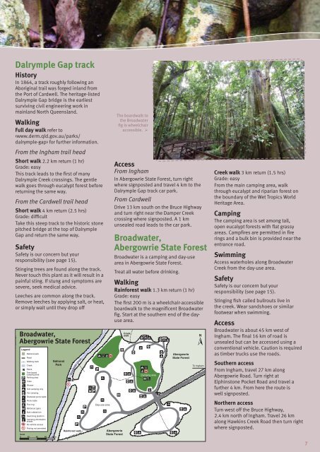
The boardwalk to<br />
the Broadwater<br />
fig is wheelchair<br />
accessible. ‣<br />
Access<br />
From Ingham<br />
In Abergowrie <strong>State</strong> Forest, turn right<br />
where signposted <strong>and</strong> travel 4 km to the<br />
Dalrymple Gap track car park.<br />
From Cardwell<br />
Drive 13 km south on the Bruce Highway<br />
<strong>and</strong> turn right near the Damper Creek<br />
crossing where signposted. A 1 km<br />
unsealed road leads to the car park.<br />
Broadwater,<br />
Abergowrie <strong>State</strong> Forest<br />
Broadwater is a camping <strong>and</strong> day-use<br />
area in Abergowrie <strong>State</strong> Forest.<br />
Treat all water before drinking.<br />
Walking<br />
Rainforest walk 1.3 km return (1 hr)<br />
Grade: easy<br />
The first 200 m is a wheelchair-accessible<br />
boardwalk to the magnificent Broadwater<br />
fig. Start at the southern end of the dayuse<br />
area.<br />
Creek walk 3 km return (1.5 hrs)<br />
Grade: easy<br />
From the main camping area, walk<br />
through eucalypt <strong>and</strong> riparian forest on<br />
the boundary of the Wet Tropics World<br />
Heritage Area.<br />
Camping<br />
The camping area is set among tall,<br />
open eucalypt forests with flat grassy<br />
areas. Campfires are permitted in fire<br />
rings <strong>and</strong> a bulk bin is provided near the<br />
entrance road.<br />
Swimming<br />
Access waterholes along Broadwater<br />
Creek from the day-use area.<br />
Safety<br />
Safety is our concern but your<br />
responsibility (see page 15).<br />
Stinging fish called bullrouts live in<br />
the creek. Wear s<strong>and</strong>shoes or similar<br />
footwear when swimming.<br />
Access<br />
Broadwater is about 45 km west of<br />
Ingham. The final 16 km of road is<br />
unsealed but can be accessed using a<br />
conventional vehicle. Caution is required<br />
as timber trucks use the roads.<br />
Southern access<br />
From Ingham, travel 27 km along<br />
Abergowrie Road. Turn right at<br />
Elphinstone Pocket Road <strong>and</strong> travel a<br />
further 4 km. From here the route is<br />
well signposted.<br />
Northern access<br />
Turn west off the Bruce Highway,<br />
2.4 km north of Ingham. Travel 26 km<br />
along Hawkins Creek Road then turn right<br />
where signposted.<br />
7<br />
7


