Woolgoolga Flood Study section 7 - Coffs Harbour City Council ...
Woolgoolga Flood Study section 7 - Coffs Harbour City Council ...
Woolgoolga Flood Study section 7 - Coffs Harbour City Council ...

You also want an ePaper? Increase the reach of your titles
YUMPU automatically turns print PDFs into web optimized ePapers that Google loves.
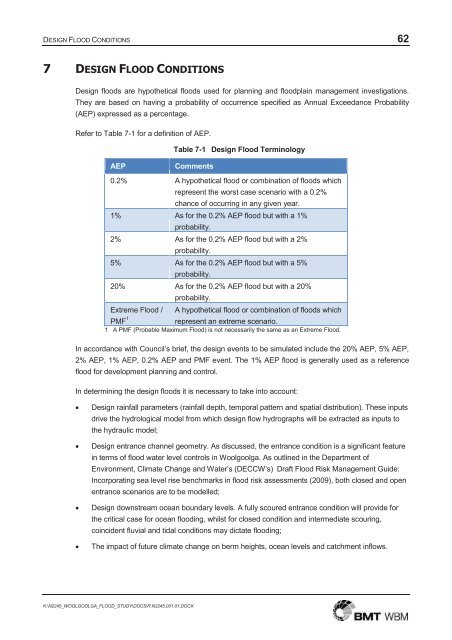
DESIGN FLOOD CONDITIONS 62<br />
7 DESIGN FLOOD CONDITIONS<br />
Design floods are hypothetical floods used for planning and floodplain management investigations.<br />
They are based on having a probability of occurrence specified as Annual Exceedance Probability<br />
(AEP) expressed as a percentage.<br />
Refer to Table 7-1 for a definition of AEP.<br />
Table 7-1 Design <strong>Flood</strong> Terminology<br />
AEP<br />
Comments<br />
0.2% A hypothetical flood or combination of floods which<br />
represent the worst case scenario with a 0.2%<br />
chance of occurring in any given year.<br />
1% As for the 0.2% AEP flood but with a 1%<br />
probability.<br />
2% As for the 0.2% AEP flood but with a 2%<br />
probability.<br />
5% As for the 0.2% AEP flood but with a 5%<br />
probability.<br />
20% As for the 0.2% AEP flood but with a 20%<br />
probability.<br />
Extreme <strong>Flood</strong> / A hypothetical flood or combination of floods which<br />
PMF 1<br />
represent an extreme scenario.<br />
1 A PMF (Probable Maximum <strong>Flood</strong>) is not necessarily the same as an Extreme <strong>Flood</strong>.<br />
In accordance with <strong>Council</strong>’s brief, the design events to be simulated include the 20% AEP, 5% AEP,<br />
2% AEP, 1% AEP, 0.2% AEP and PMF event. The 1% AEP flood is generally used as a reference<br />
flood for development planning and control.<br />
In determining the design floods it is necessary to take into account:<br />
<br />
<br />
<br />
<br />
Design rainfall parameters (rainfall depth, temporal pattern and spatial distribution). These inputs<br />
drive the hydrological model from which design flow hydrographs will be extracted as inputs to<br />
the hydraulic model;<br />
Design entrance channel geometry. As discussed, the entrance condition is a significant feature<br />
in terms of flood water level controls in <strong>Woolgoolga</strong>. As outlined in the Department of<br />
Environment, Climate Change and Water’s (DECCW’s) Draft <strong>Flood</strong> Risk Management Guide:<br />
Incorporating sea level rise benchmarks in flood risk assessments (2009), both closed and open<br />
entrance scenarios are to be modelled;<br />
Design downstream ocean boundary levels. A fully scoured entrance condition will provide for<br />
the critical case for ocean flooding, whilst for closed condition and intermediate scouring,<br />
coincident fluvial and tidal conditions may dictate flooding;<br />
The impact of future climate change on berm heights, ocean levels and catchment inflows.<br />
K:\N2245_WOOLGOOLGA_FLOOD_STUDY\DOCS\R.N2245.001.01.DOCX
DESIGN FLOOD CONDITIONS 63<br />
7.1 Changes to the Model Configuration<br />
The hydrologic and hydraulic models were developed through the model calibration process.<br />
However, there were a number of changes to the model required for design purposes, including:<br />
<br />
<br />
<br />
The construction of the <strong>Woolgoolga</strong> bypass was underway during the undertaking of this study.<br />
Design information relating to the road elevations and bridge crossings of <strong>Woolgoolga</strong> Creek and<br />
Poundyard Creek were provided by <strong>Council</strong> and incorporated into the design model geometry;<br />
A number of locations zoned for future development in <strong>Council</strong>s LEP were considered as<br />
developed when determining runoff from the hydrological model; and<br />
Recent stormwater drainage works have been undertaken by <strong>Council</strong> to improve local drainage<br />
on Trafalgar Street and provide some local flood relief. Details of these works were provided by<br />
<strong>Council</strong> and incorporated into the design model.<br />
A map showing the locations of these model developments is provided in Figure 7-1.<br />
7.2 Simulated Design Events<br />
In consultation with <strong>Council</strong> a suite of design event scenarios was defined that is most suitable for<br />
future floodplain management planning in <strong>Woolgoolga</strong>. Consideration was given to flood events<br />
driven by both catchment and ocean processes. The potential impact of climate change on flood<br />
behaviour within <strong>Woolgoolga</strong> has also been considered.<br />
7.2.1 Catchment Derived <strong>Flood</strong> Events<br />
A range of design events was defined to model the behaviour of catchment derived flooding within<br />
<strong>Woolgoolga</strong> including the 20% AEP, 5% AEP, 2% AEP, 1% AEP, 0.2% AEP and PMF events. An<br />
overview of adopted model conditions for these design events is presented in Table 7-2. The adopted<br />
storm durations are discussed in Section 7.3.4. The adopted ocean boundary conditions are<br />
discussed in Section 7.4.1.<br />
7.2.2 Ocean Derived <strong>Flood</strong> Events<br />
A range of design events was defined to model the behaviour of ocean derived flooding within<br />
<strong>Woolgoolga</strong> including the 20% AEP, 5% AEP, 2% AEP, 1% AEP and 0.2% AEP events. An overview<br />
of adopted model conditions for these design events is presented in Table 7-3. The adopted ocean<br />
boundary conditions are discussed in Section 7.4.2.<br />
7.2.3 Coincident <strong>Flood</strong> Events<br />
A range of design events was defined to model the behaviour of coincident flooding from both<br />
catchment and ocean sources within <strong>Woolgoolga</strong> including the 20% AEP, 5% AEP, 2% AEP, 1%<br />
AEP and 0.2% AEP events. An overview of adopted model conditions for these design events is<br />
presented in Table 7-4. The adopted ocean boundary conditions are discussed in Section 7.4.2.<br />
K:\N2245_WOOLGOOLGA_FLOOD_STUDY\DOCS\R.N2245.001.01.DOCX
DESIGN FLOOD CONDITIONS 64<br />
Figure 7-1<br />
Location of Model Developments for Design Scenarios<br />
K:\N2245_WOOLGOOLGA_FLOOD_STUDY\DOCS\R.N2245.001.01.DOCX
DESIGN FLOOD CONDITIONS 65<br />
Table 7-2 Design Model Runs for Catchment Derived <strong>Flood</strong> Events<br />
Design <strong>Flood</strong> Rainfall Berm Geometry<br />
Ocean Boundary Peak<br />
Water Level (m AHD)<br />
20% AEP<br />
20% AEP 2h duration<br />
20% AEP 6h duration<br />
Closed (1.5m AHD<br />
Berm Saddle)<br />
0.60 (Regular Neap Tide)<br />
20% AEP 48h duration<br />
5% AEP<br />
5% AEP 2h duration<br />
5% AEP 6h duration<br />
Closed (1.5m AHD<br />
Berm Saddle)<br />
0.60 (Regular Neap Tide)<br />
5% AEP 48h duration<br />
2% AEP<br />
2% AEP 2h duration<br />
2% AEP 6h duration<br />
Closed (1.5m AHD<br />
Berm Saddle)<br />
0.60 (Regular Neap Tide)<br />
2% AEP 48h duration<br />
1% AEP<br />
1% AEP 2h duration<br />
1% AEP 6h duration<br />
Closed (1.5m AHD<br />
Berm Saddle)<br />
0.60 (Regular Neap Tide)<br />
1% AEP 48h duration<br />
0.2% AEP<br />
0.2% AEP 2h duration<br />
0.2% AEP 6h duration<br />
Closed (1.5m AHD<br />
Berm Saddle)<br />
0.60 (Regular Neap Tide)<br />
0.2% AEP 48h duration<br />
PMF<br />
PMP 1.5h duration<br />
PMP 3h duration<br />
Closed (1.5m AHD<br />
Berm Saddle)<br />
2.70 (0.2% AEP)<br />
Table 7-3 Design Model Runs for Ocean Derived <strong>Flood</strong> Events<br />
Design <strong>Flood</strong> Rainfall Berm Geometry<br />
Ocean Boundary Peak<br />
Water Level (m AHD)<br />
20% AEP No Flow Open (-0.5m AHD) 1.85 (20% AEP)<br />
5% AEP No Flow Open (-0.5m AHD) 2.10 (5% AEP)<br />
2% AEP No Flow Open (-0.5m AHD) 2.27 (2% AEP)<br />
1% AEP No Flow Open (-0.5m AHD) 2.40 (1% AEP)<br />
0.2% AEP No Flow Open (-0.5m AHD) 2.70 (0.2% AEP)<br />
K:\N2245_WOOLGOOLGA_FLOOD_STUDY\DOCS\R.N2245.001.01.DOCX
DESIGN FLOOD CONDITIONS 66<br />
Table 7-4 Design Model Runs for Coincident <strong>Flood</strong> Events<br />
Design <strong>Flood</strong> Rainfall Berm Geometry<br />
20% AEP 20% AEP 6h duration<br />
Closed (1.5m AHD<br />
Berm Saddle)<br />
20% AEP 20% AEP 6h duration Open (-0.5m AHD)<br />
Ocean Boundary Peak<br />
Water Level (m AHD)<br />
1.85 (20% AEP)<br />
1.85 (20% AEP)<br />
5% AEP 5% AEP 6h duration<br />
Closed (1.5m AHD<br />
Berm Saddle)<br />
1.85 (20% AEP)<br />
5% AEP 20% AEP 6h duration Open (-0.5m AHD)<br />
2.10 (5% AEP)<br />
2% AEP 2% AEP 6h duration<br />
Closed (1.5m AHD<br />
Berm Saddle)<br />
1.85 (20% AEP)<br />
2% AEP 20% AEP 6h duration Open (-0.5m AHD)<br />
2.27 (2% AEP)<br />
1% AEP 1% AEP 6h duration<br />
Closed (1.5m AHD<br />
Berm Saddle)<br />
2.10 (5% AEP)<br />
1% AEP 5% AEP 6h duration Open (-0.5m AHD)<br />
2.40 (1% AEP)<br />
0.2% AEP 0.2% AEP 6h duration<br />
Closed (1.5m AHD<br />
Berm Saddle)<br />
2.40 (1% AEP)<br />
0.2% AEP 1% AEP 6h duration Open (-0.5m AHD)<br />
2.70 (0.2% AEP)<br />
7.2.4 Climate Change<br />
The NSW Government has published guidelines on the practical consideration of climate change<br />
(DECCW, 2007). For <strong>Woolgoolga</strong> a range of design events was defined to model the potential<br />
impacts of future climatic change within the study catchment. There are three outcomes of current<br />
climate change predictions which may have a significant impact of flood behaviour within<br />
<strong>Woolgoolga</strong>:<br />
<br />
<br />
<br />
Future sea-level rise;<br />
Elevated berm heights, themselves a function of sea-level rise;<br />
Increased extreme rainfall intensities.<br />
These three factors were considered in combination with each other for two future horizons, 2050 and<br />
2100. The outcomes of these climate change considerations will help understand the potential<br />
changes in future flood behaviour and how to best plan for future development within the catchment.<br />
The design events for which climate change impacts were considered were therefore focussed on the<br />
main planning event – 1% AEP event. An overview of adopted model conditions for these climate<br />
change events is presented in Table 7-5.<br />
K:\N2245_WOOLGOOLGA_FLOOD_STUDY\DOCS\R.N2245.001.01.DOCX
DESIGN FLOOD CONDITIONS 67<br />
Table 7-5 Design Model Runs for Climate Change <strong>Flood</strong> Events<br />
Design <strong>Flood</strong> Rainfall Berm Geometry<br />
Ocean Boundary Peak<br />
Water Level (m AHD)<br />
1% AEP<br />
2050<br />
1% AEP<br />
2050<br />
1% AEP<br />
2050<br />
1% AEP<br />
2050<br />
1% AEP<br />
2100<br />
1% AEP<br />
2100<br />
1% AEP<br />
2100<br />
1% AEP<br />
2100<br />
1% AEP 2h duration +10%<br />
1% AEP 6h duration +10%<br />
No Flow<br />
1% AEP 6h duration +10%<br />
Closed (1.9m AHD<br />
Berm Saddle)<br />
Open (-0.1m AHD)<br />
Closed (1.9m AHD<br />
Berm Saddle)<br />
5% AEP 6h duration +10% Open (-0.1m AHD)<br />
1% AEP 6h duration +10%<br />
No Flow<br />
1% AEP 6h duration +10%<br />
Closed (2.4m AHD<br />
Berm Saddle)<br />
Open (0.4m AHD)<br />
Closed (2.4m AHD<br />
Berm Saddle)<br />
5% AEP 6h duration +10% Open (0.4m AHD)<br />
1.00 (Regular Neap Tide<br />
+0.4m to 2050)<br />
2.90 (1% AEP +0.5m to<br />
2050)<br />
2.60 (5% AEP +0.5m to<br />
2050)<br />
2.90 (1% AEP +0.5m to<br />
2050)<br />
1.50 (Regular Neap Tide<br />
+0.9m to 2100)<br />
3.60 (1% AEP +1.2m to<br />
2100)<br />
3.30 (5% AEP +1.2m to<br />
2100)<br />
3.60 (1% AEP +1.2m to<br />
2100)<br />
7.3 Design Rainfall<br />
Design rainfall parameters are derived from standard procedures defined in AR&R (2001) which are<br />
based on statistical analysis of recorded rainfall data across Australia. The derivation of location<br />
specific design rainfall parameters (e.g. rainfall depth and temporal pattern) for the study catchment is<br />
presented below.<br />
7.3.1 Rainfall Depths<br />
Design rainfall depth is based on the generation of intensity-frequency-duration (IFD) design rainfall<br />
curves utilising the procedures outlined in AR&R (2001). These curves provide rainfall depths for<br />
various design magnitudes (up to the 1% AEP) and for durations from 5 minutes to 72 hours.<br />
The Probable Maximum Precipitation (PMP) is used in deriving the Probable Maximum <strong>Flood</strong> (PMF)<br />
event. The theoretical definition of the PMP is “the greatest depth of precipitation for a given duration<br />
that is physically possible over a given storm area at a particular geographical location at a certain<br />
time of year” (AR&R, 2001). The ARI of a PMP/PMF event ranges between 10 4 and 10 7 years and is<br />
beyond the “credible limit of extrapolation”. That is, it is not possible to use rainfall depths determined<br />
for the more frequent events (1% AEP and less) to extrapolate the PMP. The PMP has been<br />
estimated using the Generalised Short Duration Method (GSDM) derived by the Bureau of<br />
Meteorology.<br />
A range of storm durations were modelled in order to identify the critical storm duration for design<br />
event flooding in the catchment. Design durations considered included the 1-hour, 2-hour, 3-hour,<br />
4.5-hour, 6-hour, 9-hour, 12-hour, 18-hour, 24-hour, 48-hour and 72-hour durations.<br />
K:\N2245_WOOLGOOLGA_FLOOD_STUDY\DOCS\R.N2245.001.01.DOCX
DESIGN FLOOD CONDITIONS 68<br />
Table 7-6 shows the average design rainfall intensities based on AR&R adopted for the modelled<br />
events.<br />
Table 7-6 Average Design Rainfall Intensities (mm/hr)<br />
Duration<br />
(hours)<br />
Design Event Frequency<br />
20% AEP 5% AEP 2% AEP 1% AEP 0.2% AEP<br />
1 58 76 90 100 126<br />
2 38.5 51 60 67 83<br />
3 29.8 39.1 46.2 52 65<br />
4.5 23.2 30.4 35.9 40.1 50<br />
6 19.1 25.2 29.7 33.2 42.1<br />
9 15.0 19.7 23.3 26.1 32.8<br />
12 12.6 16.7 19.8 22.1 27.5<br />
18 10.2 13.6 16.2 18.2 23.1<br />
24 8.62 11.7 14.0 15.7 20.4<br />
48 5.98 8.33 10.1 11.5 14.9<br />
72 4.65 6.57 8.06 9.23 12.2<br />
7.3.2 Temporal Patterns<br />
The IFD data presented in Table 7-6 provides for the average intensity (or total depth) that occurs<br />
over a given storm duration. Temporal patterns are required to define what percentage of the total<br />
rainfall depth occurs over a given time interval throughout the storm duration. The temporal patterns<br />
adopted in the current study are based on the standard patterns presented in AR&R (2001).<br />
The same temporal pattern has been applied across the whole catchment. This assumes that the<br />
design rainfall occurs simultaneously across each of the modelled sub-catchments. The direction of a<br />
storm and relative timing of rainfall across the catchment may be determined for historical events if<br />
sufficient data exists, however, from a design perspective the same pattern across the catchment is<br />
generally adopted.<br />
7.3.3 Rainfall Losses<br />
The hydrologic model parameters adopted for the design floods were based on the initial and<br />
continuing loss model, with a continuing loss of 2.5mm/h as recommended in AR&R (2001). For the<br />
initial loss AR&R recommends values between 10mm and 35mm for eastern NSW. However, testing<br />
of the hydrologic model indicated that adopting initial loss values within this range resulted in a critical<br />
duration of 6-9 hours at the <strong>Woolgoolga</strong> Creek gauge. This was contradictory to the observations<br />
made during the model calibration process.<br />
The three flood events considered during model calibration showed a 1-3 hour storm burst, within an<br />
extended period of rainfall. For each event the catchment was saturated long before the onset of the<br />
main storm burst. It was decided to adopt an initial loss value of 0mm for design purposes. This<br />
provided a critical duration of 2-3 hours at the <strong>Woolgoolga</strong> Creek gauge and is more representative of<br />
K:\N2245_WOOLGOOLGA_FLOOD_STUDY\DOCS\R.N2245.001.01.DOCX
DESIGN FLOOD CONDITIONS 69<br />
the previous significant flood events in the catchment. The peak flood flows modelled at the<br />
<strong>Woolgoolga</strong> Creek gauge with an adopted initial loss of 0mm are also supported by the flood<br />
frequency analysis presented in Section 8.2.1.<br />
7.3.4 Critical Durations<br />
The critical duration is the storm duration for a given event magnitude that provides for the peak flood<br />
conditions at the location of interest. For example, small catchments are more prone to flooding<br />
during short duration storms, while for large catchments longer durations will be more critical.<br />
The 1% AEP flood event was run for all durations to determine the critical duration for each location in<br />
the study area. The critical duration for <strong>Woolgoolga</strong> Creek was found to be the 6-hour storm, whereas<br />
for Poundyard Creek and Jarrett Creek the 2-hour storm was the critical duration. Adopting both the<br />
2-hour and 6-hour storm durations provided the critical condition across most of the modelled area. In<br />
locations where the 2-hour or 6-hour storm was not the critical duration, the peak flood level of the<br />
critical duration was typically less than 10mm greater than that of the peak flood level for the 2-hour<br />
or 6-hour storm duration.<br />
There are two locations within the modelled area for which the 2-hour and 6-hour storm durations do<br />
not provide an adequate representation of the critical conditions:<br />
<br />
<br />
Within the swamp located at the eastern end of Trafalgar Street; and<br />
Within <strong>Woolgoolga</strong> Dam.<br />
At the Trafalgar Street swamp the 48-hour duration provided the critical condition within the swamp<br />
and through the properties to the north-west. Within <strong>Woolgoolga</strong> Dam the 48-hour duration also<br />
provided the critical condition. Assumptions were made regarding the available swamp storage and<br />
initial conditions in the swamp. Further investigation of the swamp would be required to confirm the<br />
detention capacity and assist in the verification of the critical duration.<br />
The PMP has been estimated using the Generalised Short Duration Method (GSDM) derived by the<br />
Bureau of Meteorology. The critical storms using this method were found to be the 1.5-hour and the<br />
3-hour durations.<br />
7.3.5 Climate Change Impact on Design Rainfall<br />
Current guidelines predict that a likely outcome of future climatic change will be an increase in<br />
extreme rainfall intensities. Climate Change in New South Wales (CSIRO, 2004) provides projected<br />
increases in annual extreme rainfall intensities for north-east NSW of 5% for both the years 2030 and<br />
2070. The spring extreme rainfall intensities are projected to increase by 10% for the year 2070.<br />
These figures are based on a 2.5% AEP 24h duration rainfall event. Based on these guidelines a<br />
design rainfall intensity increase of 10% was selected as being appropriate for assessing the potential<br />
impact of climate change on design rainfall in the study catchment.<br />
7.4 Design Ocean Boundary<br />
Design ocean boundaries for use in flood risk assessments are recommended by Appendix A of the<br />
Draft <strong>Flood</strong> Risk Management Guide (DECCW, 2009). This appendix was formerly Guideline 5 of<br />
Ocean Boundary Conditions for Hydraulic <strong>Flood</strong> Modelling. The design ocean boundaries from Figure<br />
K:\N2245_WOOLGOOLGA_FLOOD_STUDY\DOCS\R.N2245.001.01.DOCX
DESIGN FLOOD CONDITIONS 70<br />
3 of this document are presented in Figure 7-2. The recommended normal ocean boundary has been<br />
adopted for the catchment derived flood events. However, a different approach was used to<br />
determine the ocean flood event boundaries, as discussed in Section 7.4.2.<br />
Source: Figure3, Appendix A, Draft <strong>Flood</strong> Risk Management Guide (DECCW, 2009)<br />
Figure 7-2<br />
OEH Recommended Design Ocean Boundaries<br />
7.4.1 Catchment Derived <strong>Flood</strong> Events<br />
The adopted tidal boundary for catchment derived flood events was based on the normal tide<br />
recommendation and is shown in Figure 7-3. The timing of the 0.6m AHD peak water level was<br />
adjusted to coincide with the peak catchment inflow, which occurs at between T=4 and T=5 hours.<br />
7.4.2 Ocean Derived <strong>Flood</strong> Events<br />
The design peak water levels to be adopted for the assessment of ocean derived flood events were<br />
agreed with <strong>Council</strong> and OEH, to be consistent with previous studies in the region. The adopted flood<br />
levels were 2.1m AHD for the 5% AEP event and 2.4m AHD for the 1% AEP event. These levels<br />
include the following considerations:<br />
<br />
<br />
<br />
Barometric pressure set up of the ocean surface due to the low atmospheric pressure of the<br />
storm;<br />
Wind set up due to strong winds during the storm “piling” water upon the coastline;<br />
Astronomical tide, particularly the HHWSS; and<br />
K:\N2245_WOOLGOOLGA_FLOOD_STUDY\DOCS\R.N2245.001.01.DOCX
DESIGN FLOOD CONDITIONS 71<br />
<br />
Wave set up.<br />
The appropriate design peak water levels to be used for the remaining design events were then<br />
derived through use of a log graph, presented in Figure 7-4. The peak flood levels are also provided<br />
in Table 7-7.<br />
The temporal pattern of the design boundaries for ocean derived flood events was based on the<br />
recommended ocean design events for 5% AEP, as shown in Figure 7-2. The timing of the peak<br />
water level was adjusted to coincide with the peak catchment inflow, which occurs at between T=4<br />
and T=5 hours. The water levels were then scaled accordingly to match those from Table 7-7. The<br />
design ocean boundaries used in this study are presented in Figure 7-5.<br />
Table 7-7<br />
Design Peak Ocean Water Levels<br />
Event Magnitude<br />
Gauge Level (m)<br />
20% AEP 1.85<br />
5% AEP 2.10<br />
2% AEP 2.27<br />
1% AEP 2.40<br />
0.2% AEP 2.70<br />
Figure 7-3<br />
Design Ocean Boundary – Regular Neap Tide<br />
K:\N2245_WOOLGOOLGA_FLOOD_STUDY\DOCS\R.N2245.001.01.DOCX
DESIGN FLOOD CONDITIONS 72<br />
Figure 7-4<br />
Design Peak Ocean Water Level Derivation<br />
Figure 7-5<br />
Design Boundaries for Ocean Derived <strong>Flood</strong> Events<br />
K:\N2245_WOOLGOOLGA_FLOOD_STUDY\DOCS\R.N2245.001.01.DOCX
DESIGN FLOOD CONDITIONS 73<br />
7.4.3 Climate Change<br />
Current guidelines predict that a likely outcome of future climatic change will be an increase in mean<br />
sea level. NSW Sea Level Rise Policy Statement (DECCW, 2009) provides projected increases in<br />
mean sea level for NSW of 0.4m and 0.9m, for the years 2050 and 2100 respectively. Based on<br />
these guidelines the design ocean boundaries have been raised by 0.4m and 0.9m to assess the<br />
potential impact of climate change on flood behaviour in the study catchment.<br />
Climate change may also result in an increase in the frequency and intensity of storms, further<br />
exacerbating the effects of sea level rise on coastal flood behaviour. The data provided in Projected<br />
Changes in Climatological Forcing for Coastal Erosion in NSW (CSIRO, 2007) indicates that a<br />
conservative approach would be to adopt around a 10% increase in significant wave heights for the<br />
50 year planning horizon and around a 30% increase for the 100 year planning horizon. An increase<br />
in significant wave heights for ocean events would result in an increased wave set up.<br />
Wave data for <strong>Coffs</strong> <strong>Harbour</strong> was provided by Manly Hydraulics Laboratory (MHL), with data<br />
collection funded by the Office of Environment and Heritage. The wave rider buoys are moored in<br />
around 85 m water depth, around 10 km offshore. The analysis of storm wave height ARI for different<br />
durations is based upon a data recording period at <strong>Coffs</strong> <strong>Harbour</strong> of 33 years from May 1976 to<br />
December 2009.<br />
Figure 7-6<br />
MHL Chart for <strong>Coffs</strong> <strong>Harbour</strong> Storm Wave Return Periods<br />
Figure 7-6 shows the storm wave return periods from the <strong>Coffs</strong> <strong>Harbour</strong> wave rider buoy. It can be<br />
seen that for the 1% AEP event the significant wave height is around 6.9m for the 12-hour duration.<br />
K:\N2245_WOOLGOOLGA_FLOOD_STUDY\DOCS\R.N2245.001.01.DOCX
DESIGN FLOOD CONDITIONS 74<br />
Wave setup is typically taken as 15% of the offshore wave height, which in this case is around 1m. A<br />
10% increase by 2050 and 30% increase by 2100 would therefore provide an increased flood level of<br />
0.1m and 0.3m respectively. These increases have been incorporated within the climate change<br />
assessment, on top of the 0.4m and 0.9m sea level rise allowances.<br />
7.5 Design Berm Geometry<br />
The design berm geometry has a significant influence on modelled flood levels in <strong>Woolgoolga</strong> Lake.<br />
In defining the entrance condition for the design flood analysis, consideration is given to the geometry<br />
of the berm for open and closed conditions, for existing and future scenarios considering potential<br />
sea level rise influences.<br />
7.5.1 Catchment Derived <strong>Flood</strong> Events<br />
The berm saddle height adopted for the catchment derived flooding design events is 1.5m AHD,<br />
which was agreed through consultation with <strong>Council</strong>. The design berm geometry was based on the<br />
LiDAR survey data, in which the berm crest elevation was around 1.2m AHD. The model elevations in<br />
the <strong>Woolgoolga</strong> Lake entrance have been raised by 0.3m to provide a crest elevation of 1.5m. For the<br />
5% AEP and 1% AEP events additional model scenarios have been undertaken adopting both a 1m<br />
berm saddle height and an open entrance condition, in order to assess the impact of the lake<br />
entrance conditions on peak design flood levels.<br />
7.5.2 Ocean Derived <strong>Flood</strong> Events<br />
For the ocean derived flood events Appendix A of the Draft <strong>Flood</strong> Risk Management Guide (DECCW,<br />
2009) calls for a largely unrestricted entrance condition. This has been represented through the<br />
lowering of the model elevations in the <strong>Woolgoolga</strong> Lake entrance have by 1.7m, providing an open<br />
entrance with a bed elevation of -0.5m AHD.<br />
7.5.3 Climate Change<br />
There are no government guidelines concerning the impact of future climatic change of entrance<br />
berm geometries. A change in entrance berm processes is likely to result from the predicted sea level<br />
rise and changes to coastal storm intensity. From this change, a net upward shift in typical berm<br />
heights at the entrance may be expected commensurate with sea level rise estimates.<br />
For the purposes of this study a berm height increase of 0.4m and 0.9m has been adopted for the<br />
2050 and 2100 horizons respectively. This gives a berm saddle height for catchment derived flood<br />
events of 1.9m AHD for the 2050 planning horizon and 2.4m AHD for the 2100 planning horizon. For<br />
the open entrance condition adopted for ocean derived flood events the bed elevation has been<br />
raised to -0.1m AHD and 0.4m AHD for 2050 and 2100 respectively.<br />
The <strong>Coffs</strong> <strong>Harbour</strong> Coastal Processes and Hazards Definition <strong>Study</strong> (BMT WBM, 2011) included an<br />
assessment of shoreline recession due to sea level rise, which was found to be 45m by 2050 and<br />
100m by 2100. This coastal recession has been represented in the climate change scenarios by<br />
shifting the berm position westwards by these distances.<br />
K:\N2245_WOOLGOOLGA_FLOOD_STUDY\DOCS\R.N2245.001.01.DOCX
DESIGN FLOOD CONDITIONS 75<br />
7.6 Initial Water Levels<br />
Initial water levels in <strong>Woolgoolga</strong> Lake have been set to the same level at the berm saddle height for<br />
the closed entrance condition scenarios. For open entrance conditions, the initial water levels have<br />
been set to a level similar to the sea level at the onset of the event. There is little flood storage<br />
capacity available in the lake, which peaks at a similar level to the peak sea level and is not sensitive<br />
to the initial water level. For the climate change scenarios, initial water levels in <strong>Woolgoolga</strong> Lake<br />
have been raised by 0.4m at 2050 and by 0.9m at 2100.<br />
The initial water level in <strong>Woolgoolga</strong> Dam has been set to the normal operating level of 17.86m AHD.<br />
The initial water level in the Trafalgar Street swamp has been set to the invert level of the outlet<br />
structure, which is 3.7m AHD.<br />
K:\N2245_WOOLGOOLGA_FLOOD_STUDY\DOCS\R.N2245.001.01.DOCX