Tall Buildings in Brixton 2012 - Lambeth Council
Tall Buildings in Brixton 2012 - Lambeth Council
Tall Buildings in Brixton 2012 - Lambeth Council

You also want an ePaper? Increase the reach of your titles
YUMPU automatically turns print PDFs into web optimized ePapers that Google loves.
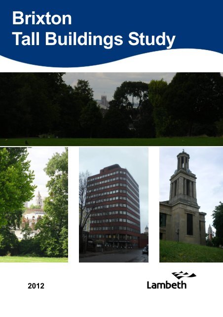
<strong>Brixton</strong><br />
<strong>Tall</strong> <strong>Build<strong>in</strong>gs</strong> Study<br />
<strong>2012</strong>
Cover Images<br />
1. Victoria Tower, Houses of Parliament from Brockwell Park<br />
2. Town Hall tower from Brockwell Park<br />
3. International House, Canterbury Crescent<br />
4. St Matthew’s Church and Town Hall towers from Effra Road<br />
International House<br />
Chartham Court<br />
Southwyck House<br />
Exist<strong>in</strong>g tall / large build<strong>in</strong>gs <strong>in</strong> <strong>Brixton</strong> as seen from the City Panorama View from Brockwell<br />
Park (policy 41 of Unitary Development Plan (2007), Saved Policies)<br />
Central <strong>Brixton</strong>’s roofscape is ornamented by slender towers and corner turrets.
Document Content<br />
Section<br />
Page<br />
1. Study Background 1<br />
2. Heritage Assets 3<br />
3. <strong>Brixton</strong> Conservation Area Statement 5<br />
4. Designated Views 7<br />
5. Other Local Views 9<br />
6. Assessment / Conclusions 11
1. Study Background<br />
1.1 This assessment document has been produced to <strong>in</strong>form the production London Borough<br />
of <strong>Lambeth</strong>’s <strong>Brixton</strong> Area Supplementary Plann<strong>in</strong>g Document (SPD) and as evidence<br />
to <strong>in</strong>form the emerg<strong>in</strong>g Draft <strong>Lambeth</strong> Local Plan. The objective be<strong>in</strong>g the identification of<br />
constra<strong>in</strong>ts affect<strong>in</strong>g the sit<strong>in</strong>g of tall build<strong>in</strong>gs, the identification of suitable sites and the<br />
guidance on appropriate heights. This document also acts as evidence base to support decision<br />
mak<strong>in</strong>g on tall build<strong>in</strong>gs. The study area for this document is the <strong>Council</strong>’s <strong>Brixton</strong><br />
SPD boundary. See map opposite.<br />
Policy Context<br />
1.2 The National Plann<strong>in</strong>g Policy Framework (NPPF) establishes that Local Plann<strong>in</strong>g<br />
Authorities should set out their strategic priorities, which should also <strong>in</strong>clude policies to deliver<br />
conservation and enhancement of the natural and historic environment, <strong>in</strong>clud<strong>in</strong>g landscap<strong>in</strong>g<br />
(paragraph 156) and identify land where development would be<br />
<strong>in</strong>appropriate due to environmental or historical significance. This follows on from the<br />
requirement that local plans should set out opportunities for development and clear policies<br />
on what will, or will not, be permitted and where (paragraph 154).<br />
1.3 The London Plan, Policy 7.7a, identifies that tall and large build<strong>in</strong>gs should be part of<br />
a strategic approach to chang<strong>in</strong>g or develop<strong>in</strong>g an area. In relation to tall build<strong>in</strong>gs, the<br />
<strong>Lambeth</strong> Core Strategy refers to the London Plan identification of Central Activities Zone<br />
and Opportunity Areas as suitable locations for tall build<strong>in</strong>gs.<br />
1.4 Policy 40 of the <strong>Council</strong>’s Unitary Development Plan, 2007 (Saved Policies, 2010)<br />
identified <strong>Brixton</strong> as an appropriate location for tall build<strong>in</strong>gs. It also states that tall build<strong>in</strong>gs<br />
should meet both visual design criteria and urban design conditions. The criteria on the opposite<br />
page is provided <strong>in</strong> extract from the UDP.<br />
<strong>Tall</strong> <strong>Build<strong>in</strong>gs</strong><br />
1.5 The <strong>Council</strong> identifies tall build<strong>in</strong>gs as those over 25 metres (adjacent to the River<br />
Thames and over 30 metres elsewhere with<strong>in</strong> the borough. These are the thresholds over<br />
which plann<strong>in</strong>g applications are referred to the Mayor and over which he has a power of direction<br />
of approval or refusal (paragraph 4.46).<br />
Best Practice<br />
1.6 The Commission for Architecture and Built Environment (CABE) / English Heritage<br />
(EH) Guidance on <strong>Tall</strong> <strong>Build<strong>in</strong>gs</strong> (2007) states that with<strong>in</strong> the strategy for design<strong>in</strong>g tall<br />
build<strong>in</strong>gs, LPAs should identify appropriate locations for tall build<strong>in</strong>gs <strong>in</strong> their development<br />
plan documents. These should be drawn up through effective engagement with local communities<br />
and with proper regard to national and regional plann<strong>in</strong>g policies and matters<br />
such as the local environment.<br />
Study Area / <strong>Brixton</strong> SPD Area<br />
1.7 The study area / <strong>Brixton</strong> SPD area boundary reflects the <strong>Brixton</strong> Town Centre boundary<br />
as def<strong>in</strong>ed <strong>in</strong> the <strong>Lambeth</strong> Core Strategy (2010) and also extends South East to <strong>in</strong>clude<br />
the Moorlands estate, the Gu<strong>in</strong>ness Trust / Loughborough Estate – areas which are highlighted<br />
as regeneration areas under Policy PN3 of the Core Strategy. Identified as a major<br />
centre <strong>in</strong> the London Plan, <strong>Brixton</strong> is one of the two largest commercial town centres <strong>in</strong><br />
<strong>Lambeth</strong> (the other be<strong>in</strong>g Streatham).<br />
1<br />
Exist<strong>in</strong>g build<strong>in</strong>g heights <strong>in</strong> the study area<br />
1.8 The average build<strong>in</strong>g height <strong>in</strong> the locality is 11.542 m, this is typical of the 3-storey<br />
build<strong>in</strong>g stock which is the norm for the area.
UDP Design Criteria for tall <strong>Build<strong>in</strong>gs</strong> (from Policy 40– <strong>Tall</strong> <strong>Build<strong>in</strong>gs</strong>)<br />
Visual Design Criteria:<br />
If the location criteria are met, then the tall build<strong>in</strong>g will<br />
need to meet the follow<strong>in</strong>g visual design criteria:<br />
In view of the <strong>in</strong>evitable prom<strong>in</strong>ence of a tall build<strong>in</strong>g it<br />
should be of the highest architectural and constructional<br />
quality.<br />
It should enhance the skyl<strong>in</strong>e through profile and use of<br />
materials.<br />
Bulky, solid structures or build<strong>in</strong>gs with unsightly roof<br />
plant will not be permitted.<br />
Be constructed to the standard of quality, design, and<br />
Urban Design:<br />
<strong>Tall</strong> build<strong>in</strong>gs should create pedestrian friendly spaces,<br />
a suitable high quality public realm, improv<strong>in</strong>g the<br />
sense of place and identity, and address streets (and<br />
potentially the river) with active ground floor uses. The<br />
<strong>Council</strong> will also have regard to the follow<strong>in</strong>g considerations:<br />
The development should <strong>in</strong>teract with, and contribute<br />
to its surround<strong>in</strong>gs at street level.<br />
Development should provide a proper sett<strong>in</strong>g and treatment,<br />
<strong>in</strong>clud<strong>in</strong>g the provision of mixed uses, active<br />
frontage uses where appropriate, considerable improvements<br />
to the public realm, and landscaped open<br />
space<br />
The build<strong>in</strong>g should achieve a harmonious relationship<br />
when viewed <strong>in</strong> context with surround<strong>in</strong>g build<strong>in</strong>gs at<br />
street level and as part of the public realm.<br />
The development should have access, servic<strong>in</strong>g, and<br />
entrances that do not detract from their surround<strong>in</strong>gs;<br />
The amenities and development possibilities of surround<strong>in</strong>g<br />
sites and build<strong>in</strong>gs should not be impaired.<br />
Where this cannot be demonstrated, the proposal<br />
should be part of, or accompanied by, a wider masterplan<br />
or development framework.<br />
2
2. Heritage Assets<br />
2.1 The <strong>Brixton</strong> study area is rich <strong>in</strong> designated and undesignated heritage assets.<br />
Statutory Listed <strong>Build<strong>in</strong>gs</strong> (designated heritage Asset)<br />
2.2 The <strong>Council</strong> has a statutory obligation to pay special regard to the desirability of preserv<strong>in</strong>g<br />
the special <strong>in</strong>terest of listed build<strong>in</strong>gs; <strong>in</strong>clud<strong>in</strong>g their sett<strong>in</strong>gs. There are Xx statutory<br />
listed build<strong>in</strong>gs with<strong>in</strong> or immediately adjo<strong>in</strong><strong>in</strong>g the SPD area. These tend to be 19th<br />
century build<strong>in</strong>gs—vary<strong>in</strong>g greatly <strong>in</strong> status and character—from the modest two storey former<br />
St John’s School on Canterbury Grove to <strong>Brixton</strong> Town Hall.<br />
Locally Listed <strong>Build<strong>in</strong>gs</strong> (undesignated heritage assets)<br />
2.3 The <strong>Council</strong> ma<strong>in</strong>ta<strong>in</strong>s a list of build<strong>in</strong>gs of local architectural or historic <strong>in</strong>terest—the<br />
‘local list’. Local plann<strong>in</strong>g policy seeks the sympathetic retention of locally listed build<strong>in</strong>gs.<br />
Conservation Areas (designated heritage assets)<br />
2.4 Areas of special architectural or historic <strong>in</strong>terest are designated by the <strong>Council</strong> under<br />
national legislation. When consider<strong>in</strong>g proposals affect<strong>in</strong>g conservation areas the law requires<br />
the <strong>Council</strong> to pay special regard to the desirability of preserv<strong>in</strong>g of enhanc<strong>in</strong>g the<br />
character or appearance of the area.<br />
2.5 <strong>Brixton</strong> Conservation Area (CA26) forms the heart of the SPD area. It is characterised<br />
by 19th and early 20th Century commercial development. Build<strong>in</strong>g heights range from<br />
3—5 storeys. The palette of materials is typical of the period with brick be<strong>in</strong>g dom<strong>in</strong>ant with<br />
some use of faience. A number of landmark build<strong>in</strong>gs are characterised by towers and<br />
spires which gives a varied and rich roofscape. Other than historic towers there are no<br />
other tall build<strong>in</strong>gs with the conservation area. However, some adjo<strong>in</strong> the boundary.<br />
2.6 Tr<strong>in</strong>ity Gardens Conservation Area (CA18) sits immediately to the west of the town<br />
centre and is only partly with<strong>in</strong> the SPD area. It is largely characterised by 19th Century<br />
residential development of 2—4 storeys. The largest build<strong>in</strong>g is the former Santley Street<br />
School which is a 5—6 storey London Board School located some distance from the study<br />
area.<br />
2.7 Rush Common & <strong>Brixton</strong> Hill Conservation Area (CA49) lies immediately to the south<br />
of central <strong>Brixton</strong>. It has a mixed character of 19th and 20th Century residential development<br />
and the Rush Common Open Space. 20th Century residential development at the<br />
north end of the conservation area (nearest the SPD area) does not exceed 6 storeys.<br />
2.8 Loughborough Park Conservation Area (CA27) sits to the east of central <strong>Brixton</strong>. It is<br />
largely characterised by early—mid 19th Century residential development although there is<br />
a commercial frontage on the north side of Coldharbour Lane. The build<strong>in</strong>g heights of<br />
traditional build<strong>in</strong>gs do not generally exceed 3 storeys. Modern blocks front<strong>in</strong>g Coldharbour<br />
Lane are <strong>in</strong> the region of 6 storeys.<br />
Conclusion<br />
2.9 Assessment shows that tall build<strong>in</strong>gs are not a characteristic element of the historic<br />
environment around central <strong>Brixton</strong>. For this reason the conservation areas and the immediate<br />
sett<strong>in</strong>gs of listed build<strong>in</strong>gs are not considered suitable locations for tall build<strong>in</strong>gs.<br />
3
Heritage Assets Map<br />
5<br />
3<br />
2<br />
1<br />
4<br />
5<br />
<strong>Brixton</strong> Conservation Areas:<br />
1) <strong>Brixton</strong> Conservation Area (CA26)<br />
2) Tr<strong>in</strong>ity Gardens Conservation Area (CA18)<br />
3) Loughborough Park Conservation Area (CA27)<br />
4) Rush Common & <strong>Brixton</strong> Hill Conservation Area (CA49)<br />
5) Archaeological Priority Area—Bristol Causeway<br />
4
3. <strong>Brixton</strong> Conservation Area Statement (<strong>2012</strong>)<br />
3.1 The <strong>Brixton</strong> Conservation Area Statement (<strong>2012</strong>) identifies views of note:<br />
3.2 A Distant views of roofscape from Brockwell Park where the numerous towers and<br />
turrets can be appreciated.<br />
3.3 B Views of roofscape and streetscape from tra<strong>in</strong>s travell<strong>in</strong>g along the elevated<br />
railway viaducts and from the platforms of <strong>Brixton</strong> Station. These are not all shown on<br />
the map opposite for reasons of clarity although the length of track from which views<br />
are made is outl<strong>in</strong>ed <strong>in</strong> red. Of particular note is the views down Electric Avenue and<br />
towards <strong>Brixton</strong> Road. The views from the railway platform (B) radiate out to the<br />
North and South of the platform.<br />
3.4 C Views of <strong>Lambeth</strong> Town Hall <strong>in</strong>clud<strong>in</strong>g its landmark tower: generally these views<br />
can be obta<strong>in</strong>ed from many vantage po<strong>in</strong>ts both from with<strong>in</strong> and outside the<br />
conservation area and appreciation of these should not be impaired. Specific views<br />
north and south along <strong>Brixton</strong> Road & <strong>Brixton</strong> Hill, west along Coldharbour Lane and<br />
East along Acre Lane are of particular importance and should be safeguarded from<br />
<strong>in</strong>terruption. These are not shown on the map opposite because of their sheer number<br />
but <strong>in</strong>clude views west from tra<strong>in</strong>s on the railway viaduct as it crosses Coldharbour<br />
Lane (one of the railway views).<br />
3.5 D Views of St Matthew’s Church, especially the tower and lantern: generally these<br />
views can be obta<strong>in</strong>ed from many vantage po<strong>in</strong>ts both from with<strong>in</strong> and outside the<br />
conservation area and appreciation of these should not be impaired. Specific views<br />
north long Effra Road, south along <strong>Brixton</strong> Road, up Kellett Road and north up <strong>Brixton</strong><br />
Hill are of particular importance and should be safeguarded from harm.<br />
3.6 E Views of the Railway Hotel, 20 Atlantic Road: this impressive late Victorian<br />
Public House is a local landmark and views of its clock tower with 6 faces and gilt<br />
weather vane ris<strong>in</strong>g above is visible <strong>in</strong> views east and west along Atlantic Road and<br />
north wards along Electric Lane. The views as demonstrated on the map, at right,<br />
cover a central part of <strong>Brixton</strong>. The Railway Hotel can be seen from several locations,<br />
as the clock tower and weather vane are both identifiable features. This landmark<br />
fades <strong>in</strong> and out of view mov<strong>in</strong>g up Atlantic Road and <strong>Brixton</strong> Road.<br />
5
<strong>Brixton</strong> Conservation Area Statement (<strong>2012</strong>) Views<br />
A<br />
B<br />
E<br />
E<br />
E<br />
B<br />
A<br />
6
4. Designated Views<br />
Strategic Views<br />
4.1 None of the Mayor of London’s Strategic Views cover the <strong>Brixton</strong> study area.<br />
Local Views<br />
4.2 The <strong>Lambeth</strong> UDP (Saved Policies 2010) identifies a number of views of local significance.<br />
The emerg<strong>in</strong>g Draft Local Plan further expands upon this; identify<strong>in</strong>g views of local<br />
<strong>in</strong>terest <strong>in</strong> Policy 41. Relevant locally important views are those northwards from Brockwell<br />
Park as they pass through the study area. They are:<br />
Brockwell Park City panorama (1a)<br />
4.3 This wide view falls across all but the south west corner of the study area. The objective<br />
of the view is to protect roofscape views across <strong>Lambeth</strong> towards the landmark build<strong>in</strong>gs<br />
of the city beyond (St Paul’s Cathedral, The Shard etc). Southwyck House (AKA <strong>Brixton</strong><br />
Barrier Block) is considered to be a negative element because its bulky slab form acts<br />
as a visual barrier.<br />
4.4 Whilst tall build<strong>in</strong>gs are not excluded with<strong>in</strong> the view given the proximity of the study<br />
area to the view<strong>in</strong>g locations slender and graceful forms are considered to be the most appropriate<br />
forms for tall development given that they will have the least impact on the wider<br />
view.<br />
Brockwell Park to Houses of Parliament L<strong>in</strong>ear View (1b)<br />
4.5 This is a tight view corridor from Brockwell Park to the Victoria Tower. It cuts north<br />
across the centre of the study area (over the roof of the <strong>Brixton</strong> Academy build<strong>in</strong>g). Given<br />
the narrow nature of this view no tall development is considered appropriate <strong>in</strong> the view corridor<br />
as it would adversely affect the viewers appreciation of the silhouette of the Victoria<br />
Tower. In the foreground of the study area exist<strong>in</strong>g build<strong>in</strong>gs heights need to be respected<br />
<strong>in</strong> order to protect this view.<br />
Brockwell Park to <strong>Brixton</strong>’s Historic Towers<br />
4.6 The towers of <strong>Lambeth</strong> Town Hall and St Matthew’s Church are the focal po<strong>in</strong>ts with<strong>in</strong><br />
this view. The grade II* listed St Matthew's Church, <strong>Brixton</strong> Hill, was built <strong>in</strong> 1822. It is <strong>in</strong><br />
the Greek Revival style and tower is 36m high. The <strong>Lambeth</strong> Town Hall is <strong>in</strong> the Edwardian<br />
Baroque style with a dist<strong>in</strong>ctive 40m tower. Both towers are slender and graceful local<br />
landmarks. <strong>Tall</strong> build<strong>in</strong>g development is not considered acceptable <strong>in</strong> this view corridor<br />
(foreground and immediate backdrop) as it is likely to prevent an the appreciation of these<br />
landmark towers.<br />
Conclusion<br />
4.7 Assessment shows that local view corridors place a constra<strong>in</strong>t on build<strong>in</strong>gs heights<br />
with<strong>in</strong> parts of the study area.<br />
7
Map show<strong>in</strong>g relevant UDP Views (Policy 41)<br />
Brockwell Park City Panorama<br />
8
5. Other Local Views<br />
5.1 Not withstand<strong>in</strong>g the other views identified <strong>in</strong> previous studies / local designations an<br />
assessment was taken around the study area <strong>in</strong> order to identify other views of note. These<br />
are identified on the map opposite and expla<strong>in</strong>ed below:<br />
Acre Lane<br />
5.2 The view East along Acre Lane (from the junction with Concannon Road) provides<br />
view of the Town Hall tower . At first the tower is glimpsed between trees and then appears<br />
as the ma<strong>in</strong> focal po<strong>in</strong>t on the horizon.<br />
<strong>Brixton</strong> Hill<br />
5.3 <strong>Brixton</strong> Hill provides a series of k<strong>in</strong>etic views north of both St Matthew’s Church tower<br />
and the Town Hall tower . Both towers drop <strong>in</strong> an out of view depend<strong>in</strong>g on the seasonality<br />
of surround<strong>in</strong>g foliage. At times this view is enhanced by tall build<strong>in</strong>gs (such as the Shard)<br />
aga<strong>in</strong>st the backdrop of generally low local build<strong>in</strong>gs.<br />
<strong>Brixton</strong> Railway Station<br />
5.4 The elevated platforms of the railway station provides a vantage po<strong>in</strong>t from which to<br />
see along Atlantic Road and onto <strong>Brixton</strong> Road. Roofscape views are important. Along the<br />
elevated platform is an opportunity to look down on Electric Avenue, watch the market and<br />
street scene below. Additionally vantage po<strong>in</strong>ts from mov<strong>in</strong>g tra<strong>in</strong>s demonstrate the various<br />
scenes of <strong>Brixton</strong>.<br />
Our Lady of the Rosary Church Tower<br />
5.5 The view from tra<strong>in</strong>s cross<strong>in</strong>g the <strong>Brixton</strong> Road railway bridge affords a view North up<br />
<strong>Brixton</strong> Road to the tower of Our Lady of the Rosary Church (opposite Max Roach Park).<br />
The street scene also highlights various town features which can been seen <strong>in</strong> and out of<br />
the conservation area.<br />
Coldharbour Lane<br />
5.6 Coldharbour Lane provides a view west of the Town Hall tower.<br />
Effra Road<br />
5.7 One of better views of St Matthew’s Church tower appears from the South on Effra<br />
Road.<br />
Conclusion<br />
5.8 Not all the local views would be affected by tall build<strong>in</strong>g development. However, many<br />
are of landmark towers the sett<strong>in</strong>g or silhouette of which could be compromised by tall build<strong>in</strong>g<br />
development. Some local views therefore will present a constra<strong>in</strong>t on tall build<strong>in</strong>g locations.<br />
The view north from tra<strong>in</strong>s pass<strong>in</strong>g<br />
over <strong>Brixton</strong> Road.<br />
9
Other Local Views<br />
<strong>Brixton</strong> Hill<br />
Effra Road<br />
10
6. Assessment / Conclusions<br />
6.1 By over-layer<strong>in</strong>g the various constra<strong>in</strong>ts with<strong>in</strong> the study area it becomes apparent<br />
that their distribution is concentrated. For example heritage assets and build<strong>in</strong>gs with<br />
landmark towers tend to be with<strong>in</strong> the conservation area, so do most of the townscape<br />
views of note.<br />
6.2 Us<strong>in</strong>g this detailed understand<strong>in</strong>g of the constra<strong>in</strong>ts, assisted with 3D modell<strong>in</strong>g to test<br />
assumptions, the opportunities for tall build<strong>in</strong>gs with<strong>in</strong> the study area boundary are limited<br />
to two areas which are identified, along with the constra<strong>in</strong>ts, on the map opposite.<br />
<strong>Brixton</strong> Central and Canterbury Estate (BC)<br />
6.3 This is the area bounded by <strong>Brixton</strong> Station Road, Popes Road and Canterbury<br />
Crescent (<strong>in</strong>clud<strong>in</strong>g the temporary ice r<strong>in</strong>k site, the park<strong>in</strong>g area for market traders and the<br />
adjo<strong>in</strong><strong>in</strong>g Canterbury Estate. On this site International House is 12 storeys + plant and the<br />
Canterbury Estate already has one tall build<strong>in</strong>g - Chartham Court (16 storeys + plant). The<br />
follow<strong>in</strong>g design parameters need to be considered:<br />
6.4 <strong>Tall</strong> build<strong>in</strong>g should be avoided at the corner of Popes Road and Canterbury Crescent<br />
to protect the sett<strong>in</strong>g of the former St John’s School (a listed build<strong>in</strong>g), prevent an<br />
unacceptably close relationship with <strong>in</strong>ternational House (both visually and <strong>in</strong> terms of<br />
amenity) and to protect the sett<strong>in</strong>g of the <strong>Brixton</strong> Conservation Area.<br />
Southwyck House (SH) and Moorlands Estate (northern part only)<br />
6.5 The exist<strong>in</strong>g Southwyck House (9 storeys high) and the low rise hous<strong>in</strong>g to its<br />
immediate south. With<strong>in</strong> the Southwyck Site, the recommended development is to the<br />
North Western corner due to its proximity the town centre. The north eastern corner is<br />
considered sensitive due to the proximity of the Loughborugh park Conservation Area and<br />
statutory listed build<strong>in</strong>gs with<strong>in</strong> it. The southern part of the estate is f<strong>in</strong>e gra<strong>in</strong>, low-rise<br />
residential build<strong>in</strong>g stock, further from the town centre which would not be appropriate for<br />
tall build<strong>in</strong>g development.<br />
Design Advice<br />
6.6 <strong>Tall</strong> build<strong>in</strong>g development on these sites to a height of 10 storeys is likely to have a<br />
neutral impact on the <strong>Brixton</strong>’s heritage assets (and their sett<strong>in</strong>gs). Development between<br />
10 and 15 storeys will be visible from with<strong>in</strong> the conservation areas and has the potential to<br />
have an adverse impact (subject to sit<strong>in</strong>g, design and other considerations). Development<br />
<strong>in</strong> excess of 15 storeys may have a significant adverse impact.<br />
6.7 Applicants propos<strong>in</strong>g tall build<strong>in</strong>gs <strong>in</strong> excess of 10 storeys should be asked to prepare<br />
accurate heritage and townscape impact assessments to allow <strong>in</strong>formed decisions to be<br />
made. Ideally <strong>in</strong> order to mitigate such harm new tall build<strong>in</strong>gs should:<br />
1. Be slender, of elegant proportions with a good silhouette; and<br />
2. Use detail<strong>in</strong>g and materials that harmonise with the locally dist<strong>in</strong>ct palette of materials<br />
(brick and stone).<br />
By follow<strong>in</strong>g these design parameters the new structures will enhance <strong>Brixton</strong>’s already rich<br />
roofscape of historic towers. Large, bulky, squat or alien look<strong>in</strong>g structures are unlikely to be<br />
considered acceptable.<br />
11<br />
6.8 Should proposals for a cluster of tall build<strong>in</strong>gs come forward it is essential that issues<br />
of overshadow<strong>in</strong>g, microclimate and outlook / privacy (for exist<strong>in</strong>g and new residents) are<br />
considered <strong>in</strong> detail and <strong>in</strong>form the design from the outset. Cluster<strong>in</strong>g which results <strong>in</strong> solid<br />
development of tall build<strong>in</strong>gs is likely to be particularly harmful.
Constra<strong>in</strong>ts Overlay Map<br />
BC<br />
SH<br />
12
6.9 Both sites are outside of conservation areas but adjo<strong>in</strong> their boundaries. It also<br />
should be noted that tall build<strong>in</strong>gs on these sites would still sit with<strong>in</strong> the locally important<br />
Brockwell Park City Panorama (see 4.3).<br />
Major Development Opportunities<br />
6.10 The <strong>Lambeth</strong> UDP (Saved policies 2010) identifies a number of Major Development<br />
Opportunity sites <strong>in</strong> <strong>Brixton</strong>. Each with<strong>in</strong> the study area is discussed <strong>in</strong> turn below <strong>in</strong><br />
relation to their suitability for tall build<strong>in</strong>gs:<br />
MDO6—Bon Marche yard, Nursery Road / Ferndale Road<br />
6.11 This site adjo<strong>in</strong>s the <strong>Brixton</strong> Conservation Area and important locally listed build<strong>in</strong>gs.<br />
It is a small site <strong>in</strong> a constra<strong>in</strong>ed location between two elevated railways viaducts and with a<br />
very short frontage to Nursery Road. The constra<strong>in</strong>ed nature of the site makes this site<br />
unsuitable for tall build<strong>in</strong>gs.<br />
MDO7—London Underground Shaft site Electric Lane<br />
6.12 This small constra<strong>in</strong>ed site with<strong>in</strong> the conservation area is not considered suitable for<br />
development exceed<strong>in</strong>g 4 storeys given the nature of the site and its heritage context with<br />
adjo<strong>in</strong><strong>in</strong>g locally listed build<strong>in</strong>gs.<br />
MDO8—Car Park to 337 / 365 <strong>Brixton</strong> Road<br />
6.13 This site is with<strong>in</strong> the conservation area. The adjo<strong>in</strong> properties are Grade II listed<br />
build<strong>in</strong>gs. This back-land site is not considered suitable for tall build<strong>in</strong>g development.<br />
MDO9—Tesco Supermarket, 13 Acre Lane<br />
6.14 This site adjo<strong>in</strong>s the boundary with the Tr<strong>in</strong>ity Gardens Conservation Area (across the<br />
road) and is immediately west of the <strong>Brixton</strong> Conservation Area. This area is not<br />
characterised by tall build<strong>in</strong>gs. Furthermore the presence of tall build<strong>in</strong>g development is<br />
likely to harm the sett<strong>in</strong>g of the towers of the Town Hall and St Matthew’s Church <strong>in</strong> views<br />
from the East and West. For these reasons tall build<strong>in</strong>g development is not considered<br />
appropriate for this site.<br />
Hambrook House, 17 Porden Road / 2 - 7 Town Hall Parade<br />
6.15 This is a prom<strong>in</strong>ent site front<strong>in</strong>g <strong>Brixton</strong> Hill <strong>in</strong> close proximity to both the town Hall<br />
and St Matthew’s Church. The presence of tall build<strong>in</strong>g development here is likely to<br />
significantly harm the sett<strong>in</strong>g of the towers of the Town Hall and St Matthew’s Church due to<br />
their immediate proximity. For these reasons tall build<strong>in</strong>g development is not considered<br />
appropriate for this site.<br />
Images Opposite<br />
6.16 Images opposite, illustrate the potential impacts of new tall build<strong>in</strong>gs <strong>in</strong> the follow<strong>in</strong>g<br />
locations:<br />
1) <strong>Tall</strong> build<strong>in</strong>g on the Tesco Site, Acre Lane, show<strong>in</strong>g the adverse impact upon the<br />
sett<strong>in</strong>g of the Town Hall when viewed from Coldharbour Lane.<br />
2) <strong>Tall</strong> build<strong>in</strong>g on the temporary Ice R<strong>in</strong>k site as viewed from Electric Avenue.<br />
3 & 4 <strong>Tall</strong> build<strong>in</strong>g on the Canterbury Arms site as viewed from Canterbury Crescent (image<br />
3) and <strong>Brixton</strong> Station Road (image 4). Image 3 illustrates the unacceptable<br />
cumulative impact of hav<strong>in</strong>g two large build<strong>in</strong>gs so close together and the harm this<br />
causes to the Grade II listed former St John’s School. Image 4 illustrates the<br />
overpower<strong>in</strong>g impact on the sense of enclosure on the Pope’s Road townscape.<br />
13
1<br />
Note; For the purposes of analysis<br />
the footpr<strong>in</strong>t of International House<br />
was used as a model (as those<br />
familiar with <strong>Brixton</strong> can appreciate<br />
its volume). The green element <strong>in</strong><br />
each model represents 10 storeys,<br />
the blue element an additional five<br />
storeys and the red element an<br />
additional five storeys. The total on<br />
each model is 20 storeys <strong>in</strong> height.<br />
2 3 4
This document was prepared by <strong>Lambeth</strong> <strong>Council</strong>’s<br />
Conservation & Urban Design team<br />
<strong>2012</strong>