20131211-2013.12Reports
20131211-2013.12Reports
20131211-2013.12Reports

You also want an ePaper? Increase the reach of your titles
YUMPU automatically turns print PDFs into web optimized ePapers that Google loves.
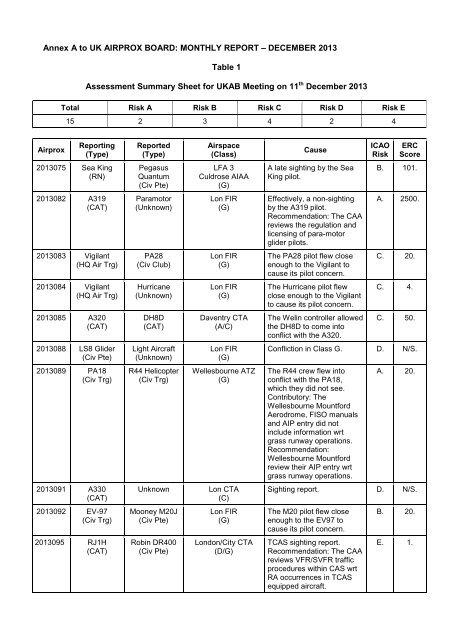
Annex A to UK AIRPROX BOARD: MONTHLY REPORT – DECEMBER 2013<br />
Table 1<br />
Assessment Summary Sheet for UKAB Meeting on 11 th December 2013<br />
Total Risk A Risk B Risk C Risk D Risk E<br />
15 2 3 4 2 4<br />
Airprox<br />
Reporting<br />
(Type)<br />
Reported<br />
(Type)<br />
Airspace<br />
(Class)<br />
Cause<br />
ICAO<br />
Risk<br />
ERC<br />
Score<br />
2013075 Sea King<br />
(RN)<br />
Pegasus<br />
Quantum<br />
(Civ Pte)<br />
LFA 3<br />
Culdrose AIAA<br />
(G)<br />
A late sighting by the Sea<br />
King pilot.<br />
B. 101.<br />
2013082 A319<br />
(CAT)<br />
Paramotor<br />
(Unknown)<br />
Lon FIR<br />
(G)<br />
Effectively, a non-sighting<br />
by the A319 pilot.<br />
Recommendation: The CAA<br />
reviews the regulation and<br />
licensing of para-motor<br />
glider pilots.<br />
A. 2500.<br />
2013083 Vigilant<br />
(HQ Air Trg)<br />
PA28<br />
(Civ Club)<br />
Lon FIR<br />
(G)<br />
The PA28 pilot flew close<br />
enough to the Vigilant to<br />
cause its pilot concern.<br />
C. 20.<br />
2013084 Vigilant<br />
(HQ Air Trg)<br />
Hurricane<br />
(Unknown)<br />
Lon FIR<br />
(G)<br />
The Hurricane pilot flew<br />
close enough to the Vigilant<br />
to cause its pilot concern.<br />
C. 4.<br />
2013085 A320<br />
(CAT)<br />
DH8D<br />
(CAT)<br />
Daventry CTA<br />
(A/C)<br />
The Welin controller allowed<br />
the DH8D to come into<br />
conflict with the A320.<br />
C. 50.<br />
2013088 LS8 Glider<br />
(Civ Pte)<br />
Light Aircraft<br />
(Unknown)<br />
Lon FIR<br />
(G)<br />
Confliction in Class G. D. N/S.<br />
2013089 PA18<br />
(Civ Trg)<br />
R44 Helicopter<br />
(Civ Trg)<br />
Wellesbourne ATZ<br />
(G)<br />
The R44 crew flew into<br />
conflict with the PA18,<br />
which they did not see.<br />
Contributory: The<br />
Wellesbourne Mountford<br />
Aerodrome, FISO manuals<br />
and AIP entry did not<br />
include information wrt<br />
grass runway operations.<br />
Recommendation:<br />
Wellesbourne Mountford<br />
review their AIP entry wrt<br />
grass runway operations.<br />
A. 20.<br />
2013091 A330<br />
(CAT)<br />
Unknown<br />
Lon CTA<br />
(C)<br />
Sighting report. D. N/S.<br />
2013092 EV-97<br />
(Civ Trg)<br />
Mooney M20J<br />
(Civ Pte)<br />
Lon FIR<br />
(G)<br />
The M20 pilot flew close<br />
enough to the EV97 to<br />
cause its pilot concern.<br />
B. 20.<br />
2013095 RJ1H<br />
(CAT)<br />
Robin DR400<br />
(Civ Pte)<br />
London/City CTA<br />
(D/G)<br />
TCAS sighting report.<br />
Recommendation: The CAA<br />
reviews VFR/SVFR traffic<br />
procedures within CAS wrt<br />
RA occurrences in TCAS<br />
equipped aircraft.<br />
E. 1.
Airprox<br />
Reporting<br />
(Type)<br />
Reported<br />
(Type)<br />
Airspace<br />
(Class)<br />
Cause<br />
ICAO<br />
Risk<br />
ERC<br />
Score<br />
2013097 ASH 26<br />
(Civ Pte)<br />
C182<br />
(Civ Pte)<br />
Lon FIR<br />
(G)<br />
A late sighting by both<br />
pilots.<br />
B. 4.<br />
2013099 RJ1H<br />
(CAT)<br />
R44<br />
(Civ Pte)<br />
London City CTR<br />
(D)<br />
TCAS sighting report.<br />
Recommendation: The CAA<br />
reviews VFR/SVFR traffic<br />
procedures within CAS wrt<br />
RA occurrences in TCAS<br />
equipped aircraft.<br />
E. 1.<br />
2013101 Tucano T1<br />
(HQ Air Trg)<br />
Glider<br />
(Unknown)<br />
Vale of York AIAA<br />
(G)<br />
A conflict in Class G<br />
airspace.<br />
C. 4.<br />
2013103 Tornado GR4<br />
(HQ Air Ops)<br />
AS350<br />
(Civ Comm)<br />
Scotland FIR<br />
(G)<br />
Sighting report. E. 1.<br />
2013121 RJ1H<br />
(CAT)<br />
A109<br />
(Civ Exec)<br />
London City CTR<br />
(D)<br />
TCAS sighting report.<br />
Recommendation: The CAA<br />
reviews VFR/SVFR traffic<br />
procedures within CAS wrt<br />
RA occurrences in TCAS<br />
equipped aircraft.<br />
E. 1.
AIRPROX REPORT No 2013075<br />
Date/Time: 26 Jun 2013 1122Z<br />
Position:<br />
5015N 00519W<br />
(1.5nm North of Camborne)<br />
Airspace: LFA 3 (Class: G)<br />
Culdrose AIAA<br />
Reporting Ac<br />
Reported Ac<br />
Type: Sea King Pegasus<br />
Quantum<br />
Operator: RN Civ Pte<br />
Alt/FL: 1200ft 1500ft<br />
RPS (1029hPa) QNH (NK)<br />
Weather: VMC HAZE VMC<br />
Visibility: 15km NK<br />
Reported Separation:<br />
50ft V/50m H<br />
Recorded Separation:<br />
NK<br />
0ft V/400ft H<br />
Diagram based on pilot reports<br />
and GPS log<br />
CPA 1122<br />
Culdrose MATZ<br />
1120<br />
Perranporth ATZ<br />
1118<br />
Quantum<br />
Camborne<br />
Sea King<br />
PART A: SUMMARY OF INFORMATION REPORTED TO UKAB<br />
THE SEA KING PILOT reports conducting a post-maintenance flight test, seated in the RH seat with<br />
an Observer in the LH seat. The grey camouflaged aircraft had navigation lights and HISL selected<br />
on, as was the SSR transponder with Modes A and C. The aircraft was not fitted with an ACAS. The<br />
handling pilot was operating under VFR in VMC, in receipt of a Basic Service from Culdrose APR.<br />
Whilst flying a NE-SW race track pattern, in a right hand turn at 90kt with 15° angle of bank, the<br />
handling pilot saw a high-wing microlight through the left chin window at a range of 100m. It appeared<br />
to be climbing and was converging from below. He called the confliction to the crew and increased<br />
bank angle to about 35° to avoid the microlight. He noted that, prior to entering the turn, the observer<br />
had been 'eyes in', conducting part of the flight test procedure. The microlight passed astern at a<br />
range of about 50m and slightly below; it was not observed to manoeuvre at any point. The pilot<br />
stated that it was believed the microlight was ‘underneath the nose’ of the Sea King at the point of<br />
commencing the right turn and was therefore obscured by the instrument panel. The microlight only<br />
became visible as it climbed towards the left chin window. Equipment on board the Sea King was set<br />
to interrogate ‘IFF Modes 3/A and C’; no returns were observed within 5nm of the helicopter for the<br />
duration of the flight.<br />
He assessed the risk of collision as ‘Medium’.<br />
THE QUANTUM PILOT reports conducting a pleasure flight. The yellow and blue aircraft was not<br />
fitted with lighting, an SSR transponder or an ACAS. The pilot was operating under VFR in VMC with<br />
a Basic Service from Newquay APR. In straight-and-level cruise at 50kt, heading 225°, at 1500ft on<br />
the QNH, he and his passenger saw a grey Sea King helicopter in the left 10.30 position at a range of<br />
3km. The Sea King appeared to be on a heading of about 315°, at the same altitude, before it then<br />
turned 90° right and flew past them, going in the opposite direction, at a distance of approximately<br />
2km. Just after passing them, the helicopter turned 90° to the right again to assume a heading of<br />
135°, before turning 90° right again to fly parallel with them. Due to the higher speed of the helicopter,<br />
it overtook them. It then turned right 90° back to its original heading of about 315°. At this point,<br />
because the helicopter was now on a constant relative bearing, the Quantum pilot grew anxious that<br />
the Sea King pilot was not aware of their location. At around 400ft away to his left, the helicopter<br />
turned sharply right to avoid them, at which point the Quantum pilot descended to avoid any possible<br />
1
otor wash. Shorty afterwards, Newquay APR requested that he switch frequency to his destination.<br />
The Quantum pilot stated that, having checked NOTAMS before the flight, it appeared that Culdrose<br />
was not ‘offering a service’ that day. Therefore, he felt Newquay was his only option for a Basic<br />
Service. On his return to home base that day, he spoke to a flying instructor, who checked the<br />
NOTAMS and confirmed that Culdrose were not ‘offering a service’.<br />
He assessed the risk of collision as ‘Medium’.<br />
CULDROSE ATC reports that on the day of the Airprox, the Culdrose ATC radar was operating SSR<br />
only. Culdrose APR was only aware that the Airprox had taken place when the Sea King pilot<br />
reported it on frequency at 1123. The Culdrose SUP was informed and, because the microlight pilot<br />
was not on frequency, and was non-squawking (and therefore not on the radar display), immediate<br />
action was taken to identify who was working the microlight. Newquay International reported that they<br />
had just sent a microlight en route to Lands End but could not see his primary return. Lands End<br />
reported that they had a microlight from Perranporth, inbound to them. Lands End rang back to state<br />
that they had spoken to the pilot of the microlight who reported that a Sea King had orbited and<br />
passed him twice, but that no traffic information had been passed by Newquay ATC.<br />
NEWQUAY ATC report that the Quantum pilot was in receipt of a Basic Service. The Quantum pilot<br />
did not declare an Airprox whilst on frequency and the controller did not recall any event of note.<br />
Analysis of the radar recording established that the microlight did not paint on radar at any time whilst<br />
in receipt of the ATS.<br />
Factual Background<br />
The weather at RNAS Culdrose was recorded as follows:<br />
METAR EGDR 261127Z 25005KT 9999 FEW012 FEW020TCU SCT024 BKN220 16/13 Q1032 WHT TEMPO<br />
SCT012 GRN<br />
Analysis and Investigation<br />
UKAB Secretariat<br />
Both pilots were operating under VFR in Class G airspace and had equal responsibility for<br />
collision avoidance 1 ; the Sea King pilot was required to give way 2 . Both pilots were in receipt of a<br />
Basic Service, defined as follows 3 :<br />
‘A Basic Service is an ATS provided for the purpose of giving advice and information useful for the<br />
safe and efficient conduct of flights. This may include weather information, changes of<br />
serviceability of facilities, conditions at aerodromes, general airspace activity information, and any<br />
other information likely to affect safety. The avoidance of other traffic is solely the pilot’s<br />
responsibility.<br />
Basic Service relies on the pilot avoiding other traffic, unaided by controllers/FISOs. It is<br />
essential that a pilot receiving this service remains alert to the fact that, unlike a Traffic Service<br />
and a Deconfliction Service, the provider of a Basic Service is not required to monitor the<br />
flight.’<br />
It was established that neither Eurocontrol nor the RAF Low Flying Operations Squadron had<br />
issued a NOTAM for RNAS Culdrose for the date of the incident. There was no record of the<br />
reported NOTAM and therefore any content could not be established. It was ascertained in<br />
subsequent conversation with RNAS Culdrose that the station often rang round ‘local airfields’ on<br />
a daily basis to pass on operating information that was deemed important to other airspace users.<br />
1 Rules of the Air 2007 (as amended), Rule 8 (Avoiding aerial collisions).<br />
2 ibid., Rule 9 (Converging).<br />
3 CAP774 (UK Flight Information Services), Chapter 2 (Basic Service), paragraph 1 (Definition).<br />
2
Although the microlight aircraft’s registration and home airfield was identified by Culdrose ATC on<br />
the day of the Airprox, this information was not conveyed to the Airprox Board until 23 rd October,<br />
some 4 months after the event. The microlight pilot provided a full report but his recollection of<br />
events was not assisted by the avoidable delay in notifying him. The RNAS Culdrose Occurrence<br />
Investigation did not retain a copy of the reported NOTAM. The Airprox occurred within the<br />
boundary of a notified hang/para-gliding winch-launch site with a maximum cable altitude of<br />
2300ft. The CAA 1:500,000 4 and 1:250,000 5 charts recommend that ‘aircraft should avoid<br />
overflying these sites below the indicated altitude’. The Military 1:500,000 low-flying chart displays<br />
symbology denoting winch-launched hang-gliding in the same area but without a promulgated<br />
maximum cable altitude. The UK Military Low Flying Handbook entry for LFA3 does not<br />
promulgate hang/para-gliding activity in that area.<br />
RN Occurrence Investigation<br />
The RN Occurrence Investigation concluded that the Sea King pilot was operating in VMC under<br />
a Basic Service and came into conflict with a microlight, the pilot of which elected not to obtain a<br />
TS from Culdrose [UKAB Note 1: in fact Culdrose could not have offered a TS given that it was<br />
SSR-only and the Quantum had no SSR]. While it is understood he was visual with [Sea King<br />
C/S], had he called Culdrose, then this might have delivered greater SA to all, and resulted in<br />
cued and more effective lookout from the [Sea King C/S] crew. Such a call might also have been<br />
advisable given that Culdrose was operating SSR only (which had been promulgated by NOTAM)<br />
and therefore would not have been aware of the microlight’s presence by radar. [UKAB Note 2:<br />
the relevant authority had no record of a NOTAM being issued].<br />
Comments<br />
Navy HQ<br />
The Sea King was operating VMC under a BS and came into conflict with a microlight that had<br />
elected not to call Culdrose during its transit. Whilst it is accepted that in hindsight the microlight<br />
pilot was visual with the Sea King, had he called Culdrose on his radio greater SA would have<br />
been available, especially considering that Culdrose were NOTAM’d [see UKAB Note 2 above] as<br />
operating SSR-only and would therefore not be able to see the microlight on PSR.<br />
Summary<br />
A Sea King and a Pegasus Quantum microlight aircraft flew into close proximity at a position 1.5nm<br />
North of Camborne, at about 1122 on 26 th June 2013. The Sea King pilot was conducting a postmaintenance<br />
flight airtest and was in receipt of a Basic Service from Culdrose APR. The Quantum<br />
pilot was transiting, with a Basic Service from Newquay APR.<br />
PART B: SUMMARY OF THE BOARD'S DISCUSSIONS<br />
Information available included pilots’, ATC and relevant operating authority reports. The incident was<br />
not observable on area radar recording.<br />
The Board first considered the pilots’ actions. The Sea King pilot was conducting an airtest in VMC<br />
and was in receipt of a Basic Service from Culdrose who were operating SSR-only due to the fact<br />
that their primary radar was not serviceable. The Sea King pilot stated that, prior to entering the right<br />
turn, the observer had been 'eyes in', conducting part of the airtest procedure. Members pointed out<br />
similarities between this incident and other Airprox in which pilots had been conducting airtests, and<br />
noted that the increased amount of ‘heads-in’ time associated with the airtest process often reduced<br />
the capacity for lookout. Considering the reduced capacity for lookout during an airtest, members<br />
4 Aeronautical Chart ICAO, Southern England and Wales, Edition 39 (2013).<br />
5 Topographical Air Chart of the United Kingdom, Sheet 7, The West and South Wales, Edition 9 (2013).<br />
3
commented on the chosen location (in the vicinity of a designated paraglider/microlight winchlaunching<br />
area), and, although the Quantum was in fact in transit rather than being operated from this<br />
location, opined that the airtest could sensibly have either been conducted in an area and at a height<br />
that was better deconflicted from other VFR traffic, or an extra crew member could have been carried<br />
to improve lookout in what was see-and-avoid airspace. Members also reiterated the benefit of a<br />
radar based ATS in these circumstances and noted that the Sea King crew were using on-board<br />
equipment to give them SA on other transponding aircraft. In the event, given that the microlight was<br />
not equipped with an SSR transponder, it would not have been seen on the SSR-only Culdrose radar<br />
or in the Sea King. Finally, members also commented that, notwithstanding operational imperatives,<br />
the combination of challenging weather and lack of appropriate ATS may have presented sufficient<br />
risk that the airtest could reasonably have been postponed altogether.<br />
The microlight pilot reported that he had ‘checked NOTAMs’ before take-off, one of which stated that<br />
Culdrose ‘were not offering a service’ that day, and that he therefore did not seek to obtain an ATS<br />
from them. Members agreed that it would have been advantageous for the microlight pilot to have<br />
contacted Culdrose to pass his route details to them so that they, and the aircraft they were<br />
controlling, could have benefited from the increased SA that this would have provided even though a<br />
Traffic Service would not have been possible (given that the microlight was not equipped with an SSR<br />
transponder and that Culdrose were operating SSR-only). However, the Board concluded that the<br />
microlight pilot had been led to believe that Culdrose ‘were not offering a service’ that day, and so his<br />
decision to talk instead to Newquay was understandable, and in fact laudable, in that he had<br />
consciously chosen to communicate his routing and intentions to an ATS unit near his route.<br />
With regard to the RNAS Culdrose NOTAM, the Board noted that there was no record of a NOTAM<br />
being issued for RNAS Culdrose on the date of the Airprox; members therefore wondered whether<br />
the microlight pilot may possibly have read information that had been passed by phone from RNAS<br />
Culdrose to local operators in accordance with their routine procedures. However, regardless of<br />
whether by NOTAM or phone call, the situation regarding SSR-only operations had either been<br />
misinterpreted by the microlight pilot, or had not been clearly conveyed. The Board noted that the<br />
microlight pilot’s flying instructor had also independently confirmed that ‘Culdrose were not offering a<br />
service’, so there was clearly ambiguity of some sort. Ultimately, the Board could not reconcile RNAS<br />
Culdrose’s belief that a NOTAM had been issued when in fact there was no record of such.<br />
The microlight pilot saw the Sea King at range, was able to maintain visual contact, and took avoiding<br />
action from the rotor wash when the Sea King pilot turned right to avoid him. The Sea King pilot was<br />
required to give way but the crew did not see the microlight until just before CPA; the Board therefore<br />
decided that the cause was a late sighting by the Sea King pilot, and, although effective avoiding<br />
action had been taken, safety margins were much reduced below normal.<br />
PART C: ASSESSMENT OF CAUSE AND RISK<br />
Cause:<br />
A late sighting by the Sea King pilot.<br />
Degree of Risk: B.<br />
ERC Score 6 : 101.<br />
6 Although the Event Risk Classification (ERC) trial had been formally terminated for future development at the time of the<br />
Board, for data continuity and consistency purposes, Director UKAB and the UKAB Secretariat provided a shadow<br />
assessment of ERC.<br />
4
AIRPROX REPORT No 2013082<br />
Date/Time: 18 Jul 2013 0836Z<br />
Position:<br />
5130N 00033E<br />
(7nm SSW of Southend Airport)<br />
Airspace: Lon FIR (Class: G)<br />
Reporting Ac<br />
Reported Ac<br />
Type: A319 Paramotor<br />
Operator: CAT Unknown<br />
Alt/FL: 2000ft NK<br />
QNH (NR hPa) NK (NK hPa)<br />
Weather: VMC CAVOK NK<br />
Visibility: 10km NK<br />
Reported Separation:<br />
0ft V/50m H<br />
Recorded Separation:<br />
NK V/NK H<br />
NK V/NK H<br />
PART A: SUMMARY OF INFORMATION<br />
REPORTED TO UKAB<br />
Diagram based on radar data<br />
and pilot reports<br />
Paraglider<br />
(not radar derived)<br />
Reported CPA 0836:58<br />
NM<br />
0 1 2<br />
A020<br />
A020<br />
A024↓<br />
A319<br />
↓2000ft<br />
Southend<br />
THE A319 PILOT reports positioning for an approach at Southend, level at 2000ft on Southend QNH,<br />
heading 360° at 210kt, in ‘clear, sunny’ weather. The aircraft was squawking modes 3/A, C and S,<br />
and the crew had agreed a Deconfliction Service with Southend Radar. When the aircraft was 7nm<br />
south-south-west of Southend, the crew reports seeing a paramotor with a red canopy, in their left<br />
10 o’clock position, 50m away, at the same altitude and travelling in the opposite direction. He<br />
reported seeing the paramotor when it was almost abeam their A319 and, due to the size and relative<br />
speeds of the aircraft, could not take any avoiding action.<br />
He assessed the risk of collision as ‘Very High’.<br />
THE PARAMOTOR PILOT could not be traced and, consequently, no report could be obtained<br />
THE SOUTHEND RADAR CONTROLLER reports vectoring the A319 for an ILS approach to RW06<br />
under a Deconfliction Service. When the aircraft was about 8nm away from Southend, on a bearing<br />
of around 210°, at 2000ft on the QNH of 1027hPa, the pilot reported passing ‘very close’ to a<br />
‘paraglider’ at a similar altitude. The controller could not see any conflicting returns on the radar<br />
display, and the pilot did not report taking any avoiding action.<br />
Factual Background<br />
The weather at Southend at 0820 was recorded as:<br />
METAR EGMC 180820Z 04005KT 360V080 9999 FEW010 21/15 Q1027<br />
Analysis and Investigation<br />
The Southend ATC Unit Occurrence Investigation reports that the weather conditions were<br />
good with excellent visibility; there was a little low cloud at 1000ft reported at Southend, but not a<br />
significant amount, and the A319 pilot reported no cloud in the area of the Airprox.<br />
1
Southend Radar had identified the A319 using Mode-S and had confirmed that no unknown<br />
returns were present on his radar display; replay of the radar recording of the incident supports<br />
this. The A319 was vectored initially on a heading of 350° for right base to RW06, between 2<br />
other transiting aircraft that were identified and receiving a service. Southend Radar then turned<br />
the A319 left by 15° onto a heading of 335°. The A319 was provided with a Deconfliction Service;<br />
the normal deconfliction minima that ATC seek to achieve from unknown traffic are 3000ft<br />
vertically or 5nm laterally. However, because the paramotor was neither known, nor showing on<br />
the radar display, ATC intervention was not possible and the A319 pilot was not given any<br />
warning of the conflicting traffic - it was not possible for the controller to pass either traffic<br />
information or avoiding action on an aircraft that was not being presented on the radar.<br />
Stoke microlight site is near to Southend and, within 45 minutes of the Airprox, Southend ATC<br />
had spoken to the owner, who confirmed that they had no para-gliders or para-motors based<br />
there, and nothing had yet flown from them that day.<br />
The radar recording was analysed and, whilst several intermittent primary contacts could be seen<br />
over a long time-scale, none of them could be correlated with the A319 pilot’s report. The Unit<br />
asked their technical staff and the radar manufacturer to investigate the performance of their radar<br />
with a view to improving its performance against small targets.<br />
The Radar Manufacturer reports that the paramotor was probably detected for a short period of<br />
time at the raw-radar plot data level, but that it was probably too small to be detected consistently<br />
by the radar. In order to reduce false radar returns produced by clutter, the equipment has a<br />
tracker filter, which removes raw-radar plots having a speed of less than 40kt. It is likely therefore<br />
that the raw-radar plot data did not generate a track on the radar display due to the low detection<br />
rate cause by the paramotor’s very small radar cross-section and its low speed.<br />
Southend Unit Recommendations:<br />
Recommendation 1: Southend ATE should re-engage with the radar manufacturer to see if any<br />
further optimisation of the PSR elements of the radar can be done to enhance chances of<br />
detection of very small/slow targets, particularly in areas of known Airprox concern.<br />
Recommendation 2: Southend Airport continues to seek to obtain CAS as soon as possible in<br />
order to provide better protection for aircraft flying instrument flight procedures into and out of<br />
Southend.<br />
Recommendation 3: Southend Airport to ask regular commercial operators to re-iterate to their<br />
pilots operating at Southend that not all smaller/slower targets will be detected by modern radar<br />
systems.<br />
[UKAB Note 1: These recommendations are not necessarily the view of the UK Airprox Board].<br />
CAA ATSI reports that they had access to Southend RTF, area radar recordings, together with<br />
the written reports from the Southend controller, ATSU and A319 pilot. The A319 was operating<br />
an IFR flight inbound to Southend Airport and was in receipt of a Deconfliction Service from<br />
Southend Approach.<br />
The paramotor was untraced, very likely operating VFR, and not in receipt of an air traffic service.<br />
At 0835:03, the A319 was 13.1nm south-southwest of Southend Airport. The A319 pilot contacted<br />
Southend Radar and reported descending to 3000ft on a northerly heading. The controller passed<br />
traffic information regarding a PA28, co-ordinated at 2000ft in the A319’s 1 o’clock at 2.5nm. A<br />
Deconfliction Service was agreed, and the A319 pilot reported visual with the traffic. The A319<br />
was then turned left onto a heading of 350°.<br />
2
At 0836:00 the A319 had passed abeam the south-bound PA28 and was instructed to descend to<br />
an altitude of 2000ft, with a left turn onto a heading of 335° for base leg.<br />
At 0836:50 the Radar controller passed traffic information regarding another PA28:<br />
Radar: “ [A319)c/s] traffic left er ten o’clock correction half past nine five and a half miles<br />
passing well down your left hand side is a piper arrow two thousand feet”<br />
A319: [0837:00]“That’s understood we’ve just had some kind of erm a para-glider or<br />
something like that passing very very close to our left hand side [A319)c/s]”<br />
Radar: “Roger nothing ob- seen on radar are you happy to continue on that track”<br />
A319: “Er affirm he’s passed us now but it was very close [A319)c/s]”.<br />
At 0837:33 the A319 was given a closing heading for the localiser and continued with the<br />
approach without further incident.<br />
The controller reported that there were no unknown returns shown in close proximity to the A319<br />
at the time of the Airprox, and this was confirmed by a replay of the ATSU radar recording.<br />
CAA ATSI completed an analysis of the area radar recordings, which did show a probable<br />
intermittent contact that appeared 20 seconds after the Airprox. This contact appeared 0.25nm left<br />
of the A319’s radar trail history and was shown for two sweeps of the radar followed by a final<br />
trace at 0837:58 before the contact faded from radar, as shown in figure 1.<br />
Figure 1 – Swanwick MRT at 0837:58 (UKAB Note: CPA label should read 0836:58)<br />
By measuring the distance (0.3nm) between the returns at 0837:18 and 0837:58 (40seconds), the<br />
ground speed of the unknown contact was calculated as 27knots. At this speed the contact<br />
would have travelled 0.15nm since the time of the Airprox. This is shown on Figure 1 above and,<br />
at CPA, the unknown contact was estimated to be around 0.1nm (185m) to the left of the A319<br />
[UKAB Note 2: this measurement is subject to uncertainty in radar return display inaccuracies and<br />
should not be considered as definitive].<br />
After the Airprox, the ATSU initiated tracing action but the paramotor remained untraced.<br />
3
The ATSU, in consultation with the radar manufacturer, reported that the unknown<br />
paramotor was too small in terms of radar cross-section, and was travelling too slowly to<br />
be displayed by Southend Radar. The radar processing system ‘tracker’ filter removes raw-radar<br />
plots having a speed below 40 knots in order to reduce the false alarm clutter. The calculated<br />
ground speed of the unknown contact was 27 knots. The Southend radar detection system is<br />
approved and compliant with the requirements of CAP670 ATS Safety Requirements.<br />
Following increased operations from Southend since April 2012, London Southend Airport has<br />
undertaken a formal consultation (conducted between 20 September 2013 to 19 December 2013)<br />
to seek to re-establish Controlled Airspace around Southend Airport.<br />
ATSI Analysis: The A319 was in receipt of a Deconfliction Service; a surveillance-based service<br />
under which controllers will provide surveillance-derived traffic information. However, the<br />
avoidance of other traffic is ultimately the pilot’s responsibility and the provision of the service is<br />
constrained by the unpredictable nature of the environment.<br />
Because of the paramotor’s small radar cross-section and slow speed it was not displayed by the<br />
Southend Radar system. As a result there was no specific surveillance-derived information<br />
regarding the paramotor, and the Southend Radar controller was not able to provide tactical<br />
deconfliction advice or warning to the A319 pilot.<br />
Within Class G airspace, regardless of the service being provided, pilots are ultimately responsible<br />
for collision avoidance<br />
Summary<br />
The Airprox occurred at 0836:58, 8.4nm south-west of Southend Airport, within Class G airspace,<br />
between an A319 and an untraced paramotor. The unknown paramotor was too small and too slow<br />
to be displayed by the Southend Radar system and, in the absence of surveillance-derived<br />
information, the Southend radar controller was therefore unable to provide any deconfliction advice.<br />
PART B: SUMMARY OF THE BOARD'S DISCUSSIONS<br />
Information available included a report from the crew of the A319, transcripts of the relevant RT<br />
frequencies, radar photographs/video recordings, a report from the air traffic controller involved and a<br />
report from the ATC operating authority.<br />
The Board noted that the Airprox occurred in Class G airspace, for which see-and-avoid was the<br />
primary method of collision avoidance. Both aircraft were equally entitled to be in that location, and<br />
therefore the pilots shared equal responsibility for collision avoidance. Notwithstanding, the Board<br />
observed that the paramotor pilot had probably been unwise to position himself at 2000ft so close to<br />
the approach track for Southend’s active RW06, and at a location which would have been frequented<br />
by aircraft routing to Southend for IFR approaches. The gliding member concurred, and opined that<br />
the positioning of the paramotor possibly indicated a low-level of aviation awareness by its pilot.<br />
Unfortunately, because the paramotor pilot could not be traced, the Board were unable to explore<br />
further this aspect. As an aside, the Board also noted that the fact that the pilot had not come<br />
forward himself (after what must have been a frightening event), was an additional indicator as to his<br />
likely inexperience in aviation matters.<br />
The airline members stated that, in this case, TCAS would not have been able to provide protection<br />
because the paramotor would not have been equipped with an SSR transponder or other electronic<br />
conspicuity aid. They also commented on the difficulty of seeing such small aircraft, especially from<br />
the cockpit of a much faster moving large airliner. Noting that Southend was applying for controlled<br />
airspace to be established around the airport, the airline members also wondered how likely it would<br />
be that, given the paucity of training and regulation of paramotor pilots, they would understand the<br />
requirements of controlled airspace. Even with controlled airspace established around airfields, VFR<br />
traffic operating within and around its margins needed to understand where other traffic was likely to<br />
4
e encountered, and what their associated routeing might be. The Board were informed that<br />
paramotor pilots do not require a licence to fly, although they are still required to comply with the<br />
Rules of the Air. The British Hang Gliding and Paragliding Association (BHPA) oversees pilot and<br />
instructor training standards for Free Flying, which includes the operation of paramotors, but there is<br />
no requirement for a paramotor pilot to join the BHPA. As a result, the pilot involved in this Airprox<br />
could well have been entirely independent, and could possibly have received very little training in Air<br />
Law and airmanship matters.<br />
The Board did not have a report from the paramotor pilot but members were of the unanimous<br />
opinion that he would have seen and heard the A319 pass close by. The Board could not establish<br />
whether the paramotor pilot took avoiding action but it was clear that the A319 pilot had not seen the<br />
paramotor early enough to do so himself. Both pilots were equally responsibility for collision<br />
avoidance 1 , and the A319 pilot was required to give way 2 . The Board therefore decided that the<br />
cause was an effective non-sighting by the A319 pilot. In assessing the risk, Board members noted<br />
that the A319 crew had not had time to take any avoiding action, and that the radar analysis<br />
supported the pilot’s estimate of horizontal separation. The Board were therefore unanimous in<br />
agreeing that separation had been reduced to the minimum, and that the Degree of Risk was<br />
Category A. Noting the concerns raised about ensuring the competency and training of paramotor<br />
pilots, the Board also decided to recommend that the CAA reviews the regulation and licensing of<br />
paramotor glider pilots.<br />
PART C: ASSESSMENT OF CAUSE AND RISK<br />
Cause:<br />
Effectively, a non-sighting by the A319 pilot.<br />
Degree of Risk: A.<br />
ERC Score 3 : 2500.<br />
Recommendation:<br />
The CAA reviews the regulation and licensing of paramotor glider pilots.<br />
1 Rules of the Air 2007 (as amended), Rule 8 (Avoiding aerial collisions).<br />
2 ibid., Rule 9 (Converging). A paramotor is classed as a glider in the ANO.<br />
3 Although the Event Risk Classification (ERC) trial had been formally terminated for future development at the time of the<br />
Board, for data continuity and consistency purposes, Director UKAB and the UKAB Secretariat provided a shadow<br />
assessment of ERC.<br />
5
AIRPROX REPORT No 2013083<br />
Date/Time: 20 Jul 2013 1537Z (Saturday)<br />
Position:<br />
52 04N 00017W<br />
(2nm South-east of Biggleswade)<br />
Airspace: London FIR (Class: G)<br />
Reporting Ac<br />
Type: Vigilant PA28<br />
Reported Ac<br />
Operator: HQ Air (Trg) Civ Club<br />
Alt/FL: 1800ft 1500<br />
QFE (1019hPa) QFE (1019hPa)<br />
Weather: VMC CAVOK VMC CAVOK<br />
Visibility: 10km 10km<br />
Reported Separation:<br />
100ft V/0m H<br />
Recorded Separation:<br />
NR V/
Factual Background<br />
The weather at Cranfield at 1520 was notified as:<br />
METAR EGTC 201520Z 04012KT 9999 SCT018 21/16 Q1023<br />
Analysis and Investigation<br />
UKAB Secretariat<br />
Analysis of the radar recording at 1536:20 shows the Vigilant 1.5nm north-east of Henlow, with no<br />
Mode C indication available, flying north-east, with the PA28 in its 5.30 position, 0.4nm behind,<br />
indicating an altitude of 1000ft and following a similar track. The PA28 turns slightly left to track<br />
north and, at 1536:37 has climbed from 1000ft to indicate 1300ft, still 0.4nm behind the Vigilant.<br />
At 1536:46 the PA28 manoeuvres right and then left, remaining in the Vigilant’s rear right quarter,<br />
indicating 1400ft, before its Mode C disappears when it is 0.2nm from the Vigilant. Twenty<br />
seconds later the PA28’s Mode C returns, indicating 1700ft; the Vigilant is 0.2nm ahead of the<br />
PA28. At 1537:15 the Mode C of the PA28 continues to indicate 1700ft before disappearing with<br />
the PA28 0.1nm directly behind the Vigilant. At 1537:40 the radar returns have merged, there is<br />
no measurable horizontal separation but the PA28’s Mode C has returned and indicates 2000ft.<br />
The PA28’s radar return moves ahead of the Vigilant’s at 1537:44, and then continues to pull<br />
away from it indicating 2000ft.<br />
The Vigilant had right of way because it was being overtaken by the PA28, which was required to<br />
overtake on the right. 1 The PA28 pilot reports that the student turned their aircraft to the right and<br />
estimated that they achieved 200ft H separation. Although the PA28 is shown on the radar replay<br />
in the Vigilant’s 5-5.30 position for some of the time as it approaches, the radar returns merge<br />
with no discernible horizontal separation. Furthermore, the PA28 pilot had the responsibility to<br />
‘keep out of the way’ of the Vigilant until the aircraft were clear of each other. 2 Finally, an aircraft<br />
which is obliged to give way to another aircraft is required to avoid passing over or under the other<br />
aircraft, or crossing ahead of it, unless passing well clear of it. 3 The PA28 pilot reports losing<br />
sight of the Vigilant during the overtaking manoeuvre, however, his student was able to keep it in<br />
sight and he reports that he remained well clear. At the point that the radar returns merge, the<br />
PA28’s Mode C indicates 200ft above the reported altitude of the Vigilant, which is commensurate<br />
with the PA28 pilot’s report, and close to the Vigilant pilot’s report.<br />
Comments<br />
HQ Air Command<br />
The Vigilant pilot faced a quandary in this instance; he knew a faster aircraft was approaching that<br />
would always be difficult to see, but that the rules of the air require him to maintain heading so the<br />
overtaking aircraft can avoid. However, one could argue that the Rules of the Air only apply if<br />
aircraft are visual with another, conflicting aircraft, in which case the practice of making regular<br />
changes of heading might have allowed the opportunity to acquire the following aircraft. His<br />
report indicates he adopted an appropriately defensive mindset but that the actions of the PA28<br />
crew did not ensure a safe and orderly overtake.<br />
Summary<br />
The Airprox occurred in Class G airspace, 2nm South-east of Biggleswade, between a Vigilant motorglider<br />
and a PA28, which was overtaking it. Both aircraft were carrying out instructional sorties and<br />
were flying VFR in VMC without an air traffic service.<br />
1 Rules of the Air 2007, Rule 11, para 1.<br />
2 Rules of the Air 2007, Rule 11, para 2.<br />
3 Rules of the Air 2007, Rule 8, para 4.<br />
2
PART B: SUMMARY OF THE BOARD'S DISCUSSIONS<br />
Information available included reports from the pilots of both ac and radar photographs/video<br />
recordings.<br />
The GA and gliding members lead the discussion and noted that the PA28 instructor pilot had seen<br />
the Vigilant early on as his aircraft had caught up with it, but had then allowed his student to fly into a<br />
position where the instructor could no longer see the Vigilant as they overtook it. Whilst the student<br />
had apparently maintained visual contact with the Vigilant throughout, Board members were clear<br />
that it was the instructor who had the responsibility to ensure adequate separation was maintained<br />
throughout the overtaking manoeuvre. The GA members noted that this was the latest in a series of<br />
Airprox where pilots have allowed too little separation when overtaking, or have seen another aircraft<br />
early on but still not taken timely and decisive action. The Board agreed that this observation would<br />
make a good topic for further education throughout the GA community, and particularly within the<br />
prospective 2014 Airprox edition of the CAA’s ‘Clued Up’ magazine.<br />
Turning to the actions of the Vigilant pilot, the Board felt that he had done well to build up and<br />
maintain situational awareness regarding the PA28. The Board postulated that he may have been<br />
torn between maintaining his track whilst being overtaken and manoeuvring to maintain positive<br />
visual contact with the PA28 as it overtook. Some members opined that there would have been<br />
some merit in the Vigilant pilot making some small turns for reasons of both lookout and to encourage<br />
a wider berth by the PA28 pilot; in other circumstances, whilst maintaining the same general track, a<br />
small amount of movement might also have increased the Vigilant’s visual conspicuity.<br />
The Board unanimously agreed that the cause of the Airprox was that the PA28 pilot flew close<br />
enough to cause the Vigilant pilot concern during the overtaking manoeuvre. Noting that the student<br />
in the PA28 had maintained visual contact with the Vigilant, the Board agreed that effective actions<br />
could at all times have been taken to prevent a collision, and decided that the Degree of Risk was C.<br />
PART C: ASSESSMENT OF CAUSE AND RISK<br />
Cause:<br />
The PA28 pilot flew close enough to the Vigilant to cause its pilot concern.<br />
Degree of Risk: C.<br />
ERC Score: 4 20.<br />
4 Although the Event Risk Classification (ERC) trial had been formally terminated for future development at the time of the<br />
Board, for data continuity and consistency purposes, Director UKAB and the UKAB Secretariat provided a shadow<br />
assessment of ERC<br />
3
AIRPROX REPORT No 2013084<br />
Date/Time: 20 Jul 2013 1541Z (Saturday)<br />
Position:<br />
5203N 000 13W<br />
(3nm SE of Biggleswade)<br />
Airspace: Lon FIR (Class: G)<br />
Reporting Ac<br />
Reported Ac<br />
Type: Vigilant Hurricane<br />
Operator: HQ Air (Trg) Unknown<br />
Alt/FL: 1800ft NK<br />
QFE (1019hPa)<br />
Weather: VMC CAVOK NK<br />
Visibility: 10km NR<br />
Reported Separation:<br />
0ft V/20m H<br />
Recorded Separation:<br />
NK<br />
NK<br />
PART A: SUMMARY OF INFORMATION REPORTED TO UKAB<br />
THE VIGILANT PILOT reports flying VFR, with a student, in a white motor-glider, displaying orange<br />
hi-visibility patches, with the strobe, navigation and landing lights turned on. He had selected<br />
transponder mode 3/A code 7000 (modes C & S were not fitted), and was in radio contact with<br />
Henlow Radio. The student was on a work-up sortie designed to lead to the first off-circuit solo sortie<br />
and had been briefed to operate ‘as if solo’. They discussed recent Airprox events in the area and<br />
the student was tasked with selecting a suitable operating area; they elected to operate to the east of<br />
the A1 to the south of Biggleswade, allowing a suitable margin from the line-feature to allow other<br />
pilots to navigate along it safely.<br />
The aircraft was climbed to 2000ft; after crossing the A1 the instructor was scanning to the right and<br />
noticed a ‘fast-moving aircraft’ approaching from behind. He identified it as a Hurricane, which<br />
appeared to ‘formate’ in a position around 20m from his starboard wing-tip for ‘a couple of seconds’<br />
he reported; this impression was strengthened as the Vigilant pilot recalls seeing the Hurricane pilot<br />
look across towards his aircraft. The Instructor then saw the Hurricane dive towards what he<br />
believed was the FARR Festival, at Bygrave Woods near Newnham, before commencing a series of<br />
aerobatic manoeuvres.<br />
He assessed the risk of collision as ‘Low’.<br />
THE HURRICANE: The radar recording showed a primary track, travelling at an appropriate speed<br />
for a Hurricane, but it faded 0.3nm from the Vigilant and could not be re-identified. The operators of<br />
Hurricanes in the area were contacted; the Battle of Britain Memorial Flight and the Shuttleworth<br />
Collection both confirmed that their Hurricanes were either on the ground or in another location at the<br />
time of the Airprox. Another local operator, with a Hurricane airborne at the time, declined to cooperate<br />
with the UKAB and stated that he did not wish to be contacted again regarding the matter.<br />
Factual Background<br />
The weather at Cranfield at 1550 was notified as:<br />
METAR EGTC 201550Z 02012KT 9999 SCT022 20/16 Q1023<br />
Diagram based on radar data<br />
and pilot reports<br />
Hurricane<br />
(Primary radar<br />
return only)<br />
Hurricane return<br />
fades at 1541:11<br />
Vigilant<br />
2000ft alt<br />
CPA 1541Z<br />
NM<br />
Vigilant<br />
at 1541:11<br />
0 1 2<br />
Newnham<br />
1
Analysis and Investigation<br />
UKAB Secretariat<br />
Analysis of the radar recording shows the Vigilant operating 3nm to the north-east of Henlow,<br />
tracking east with no mode C indication available. The aircraft manoeuvres left and right twice,<br />
and then crosses the A1 just before the reported time of the Airprox.<br />
A primary radar return appears 3nm to the north of Henlow, moving in a steady right-hand curving<br />
turn towards the Vigilant. The return crosses the A1 and then disappears from the recording<br />
0.3nm behind and slightly to the right of the Vigilant’s return. Primary returns can then be<br />
observed twice, ahead of the Hurricane’s track, consistent with its track speed, around 1nm to the<br />
north west of Newnham, but cannot be positively correlated with the Hurricane’s previous radar<br />
returns.<br />
The Vigilant had right of way because it was being overtaken by the Hurricane, which was<br />
required to overtake on the right. 1 The Vigilant pilot’s report and the radar recording indicate that<br />
the Hurricane passed down the right-hand side of the Vigilant. The Hurricane pilot had the<br />
responsibility to ‘keep out of the way’ of the Vigilant until the aircraft were clear of each other. 2&3<br />
The Hurricane’s radar return fades 0.3nm from the Vigilant’s return with no Mode C information<br />
available for either aircraft; given the tracks of the aircraft it is possible that the actual CPA was<br />
closer, but the Vigilant pilot’s report of 20m H cannot be corroborated by the radar recording.<br />
Comments<br />
HQ Air Command<br />
Without the report from the Hurricane pilot, assessing this Airprox is much more difficult and it is<br />
hard to identify what might be done to prevent a recurrence. The Hurricane pilot had the<br />
responsibility to avoid the Vigilant under the Rules of the Air and either did not see it or chose to<br />
fly close enough to cause concern. For their part, the Vigilant crew appear to have had<br />
reasonable situational awareness, sighting the Hurricane as it approached them initially from the<br />
outside of their turn and then from behind.<br />
Summary<br />
The Airprox occurred in Class G airspace, 3nm south-east of Biggleswade, between a Vigilant motorglider<br />
and a Hurricane, which overtook it. The Vigilant pilot was carrying out an instructional sortie<br />
and was flying VFR in VMC without an air traffic service. The Hurricane could not be definitively<br />
traced so the views of its pilot could not be included in this analysis.<br />
PART B: SUMMARY OF THE BOARD'S DISCUSSIONS<br />
Information available included a report from the Vigilant pilot and radar recordings.<br />
The Board commented that, despite the unique nature of the aircraft, it was unfortunate that the<br />
Hurricane pilot could not be definitively identified. They also commented that it was highly unhelpful<br />
that a Hurricane pilot who had been airborne at the time, and who could have been flying in that area,<br />
chose not to co-operate with the Board, even to rule himself out of the investigation. Whilst it was still<br />
possible to assess the Airprox using the Vigilant pilot’s report supported by the radar data, the Board<br />
was clear that it would have been much easier to identify lessons and compile a more accurate<br />
analysis of the event if a report from the Hurricane pilot concerned had been obtained.<br />
1 Rules of the Air 2007, Rule 11, Overtaking, para 1.<br />
2 Rules of the Air 2007, Rule 11, Overtaking, para 2.<br />
3 Rules of the Air 2007, Rule 8, Avoiding Aerial Collisions, paras 2 & 3.<br />
2
It was evident to the Board that the Vigilant pilot had seen the Hurricane early and had maintained his<br />
course and speed to allow the Hurricane to overtake. The Board members also noted that the<br />
Vigilant pilot had reported that the Hurricane pilot appeared to look across at the Vigilant. Although<br />
the radar shows a significant speed differential between the aircraft, the Hurricane return disappears<br />
before the likely CPA, and the Board opined that the geometry of the encounter, and the fact that the<br />
Hurricane reportedly appeared to briefly stabilise near the Vigilant, meant that it was very likely that<br />
the Hurricane pilot had also seen the Vigilant. For his part, the Vigilant pilot remained in visual<br />
contact throughout, and ready to take avoiding action if required, even though the awareness and<br />
intentions of the Hurricane pilot were unknown. Consequently, the Board assessed the degree of risk<br />
as C; there was no risk of collision. It was unanimously agreed that the cause of the Airprox was that<br />
the Hurricane pilot flew close enough to the Vigilant to cause its pilot concern.<br />
PART C: ASSESSMENT OF CAUSE AND RISK<br />
Cause:<br />
The Hurricane pilot flew close enough to the Vigilant to cause its pilot<br />
concern.<br />
Degree of Risk: C.<br />
ERC Score 4 : 4.<br />
4 Although the Event Risk Classification (ERC) trial had been formally terminated for future development at the time of the<br />
Board, for data continuity and consistency purposes, Director UKAB and the UKAB Secretariat provided a shadow<br />
assessment of ERC.<br />
3
AIRPROX REPORT No 2013085<br />
Date/Time: 22 Jul 2013 1906Z<br />
A320<br />
Diagram based on radar data<br />
Position:<br />
5214N 00111W<br />
(4nm NW Daventry)<br />
Airspace: Daventry CTA (Class: A/C)<br />
Reporting Ac<br />
Type: A320 DH8D<br />
Operator: CAT CAT<br />
Reported Ac<br />
Alt/FL: FL200 FL190<br />
Weather: IMC KLWD VMC CLAC<br />
Visibility: Nil 10km<br />
Reported Separation:<br />
400ft V/2nm H<br />
Recorded Separation:<br />
400ft V/6.2nm H<br />
1400ft V/2.3nm H<br />
400ft V<br />
NM<br />
10<br />
5<br />
0<br />
F205<br />
F201<br />
F199<br />
F202<br />
CPA 1906:42<br />
1400ft V/2.3nm H<br />
F203<br />
F189<br />
F190<br />
06:30<br />
F195<br />
F197<br />
06:18<br />
F198<br />
05:54<br />
06:06<br />
DH8<br />
PART A: SUMMARY OF INFORMATION REPORTED TO UKAB<br />
THE A320 PILOT reports inbound to Heathrow (LHR), under the control of London ATC Centre. Anticollision<br />
and navigation lights were illuminated, and SSR Modes C and S were selected. While<br />
deviating for weather, and in level flight at FL200, ATC instructed an immediate left turn for avoiding<br />
action. With Auto Pilot (AP) engaged, and turning left in response to the ATC instruction, he heard a<br />
TCAS RA climb instruction. AP and Flight Director (FD) were disengaged and a climb initiated in<br />
response to the RA. The aircraft climbed approximately 309ft and turned left 40°. From the TCAS<br />
read-out, he estimated that the other aircraft was never closer than 400ft. He did not see the other<br />
aircraft as he was in cloud and it was behind his aircraft. The other aircraft appeared suddenly on the<br />
TCAS display behind his aircraft and remained there until it disappeared from the display.<br />
He perceived the severity of the incident as ‘Medium’.<br />
THE DH8D PILOT reports inbound to Birmingham (BHX). Position lights and white strobes were<br />
illuminated, the landing lights were selected off. The aircraft was cleared to FL90 on descent into<br />
BHX. There was a fair amount of CB activity at approximately 20nm SE of Honiley (HON) so the<br />
aircraft was descended at 500fpm to stay above a build-up. Passing FL195, a right turn was<br />
requested and approved to avoid a CB that was on the aircraft’s track. Passing FL190 a TCAS TA<br />
was received followed closely by an RA. The AP was disengaged and the TCAS commands were<br />
followed. Concurrent with the TCAS RA, ATC gave an instruction to turn immediately onto a heading<br />
of 300° (he thought), which was carried out immediately. A similar instruction was heard to have been<br />
given to another aircraft immediately prior to this. Once clear of the conflict a report was made over<br />
the radio and clarification of any further instructions was sought.<br />
He assessed the risk of collision as ‘Low’.<br />
THE LTC WELIN CONTROLLER reports that there was a lot of weather avoidance being carried out<br />
in his sector. He had co-ordinated the DH8D to enter Cowly’s airspace from HEMEL. Because the<br />
Cowly controller had aircraft inbound to Bovingdon (BNN), he descended the DH8D to FL170 i.e.<br />
beneath all the LHR traffic in the Cowly sector. He then issued further descent to the aircraft to FL90.<br />
1
When N of DTY, inbound to HON, the pilot requested a turn onto heading 335° to avoid weather.<br />
Having approved this request, he noticed that the A320 was level at FL200 and the DH8D was<br />
passing FL197 and seemed to have stopped descending. He issued an avoiding action turn onto<br />
heading 280° and the Cowly controller also gave the A320 avoiding action. Both aircraft received<br />
TCAS RAs. He reported there was no loss of separation.<br />
THE LTC COWLY CONTROLLER reports weather avoidance was taking place. He was monitoring a<br />
trainee on TC Cowly when the A320, descending to FL200, requested a weather avoidance heading<br />
of 135°. This was approved and notified to the Welin controller who had the DH8D heading 335°,<br />
descending to FL170. A short time later the STCA flashed red when the two aircraft were about 10nm<br />
apart with the A320 level at FL200 and the DH8D observed at FL197. He took over the RTF and gave<br />
avoiding action to the A320 (left turn onto 090° degrees (he thought) and traffic information (TI) was<br />
issued). The pilot reported a TCAS RA and was seen to be climbing. The DH8D was also given<br />
avoiding action (by TC Welin) and reported a TCAS RA. There was no loss of separation.<br />
Factual Background<br />
Required minimum separation between the subject aircraft was 3nm horizontal and/or 1000ft vertical.<br />
Analysis and Investigation<br />
CAA ATSI<br />
An Airprox was reported in Class C airspace by an Airbus A320 (A320), descending to FL200 in<br />
the vicinity of Daventry when it received a TCAS RA against a Bombardier DHC-8-402 (DH8D),<br />
which was descending into Class A airspace to FL90. ATSI had access to both pilot reports,<br />
reports from the Cowly and Welin controllers, recorded area surveillance and transcription of<br />
frequencies 121.025MHz and 130.925MHz, together with the unit report.<br />
The A320 was operating IFR on a flight inbound to LHR, displaying SSR code 7664 and was in<br />
receipt of a Radar Control Service from the London Terminal Control (LTC) Cowly sector on<br />
frequency 121.025MHz.<br />
The DH8D was operating an IFR flight inbound to BHX, displaying SSR code 4406 and was in<br />
receipt of a Radar Control Service from the LTC Welin sector on frequency 130.925MHz.<br />
Training was in progress on the Cowly sector. There was a high level of Thunderstorm activity in<br />
the area which brought a high level of workload complexity for the Welin controller.<br />
At 1900:15 the DH8D pilot contacted the Welin controller descending to FL220 heading 310° and<br />
was given descent to FL170. At 1902:15 the DH8D was given further descent to FL90.<br />
At 1903:32 the A320 pilot contacted the Cowly controller descending to FL200 heading 135° due<br />
to weather. The Cowly controller advised Welin that the A320 was avoiding weather and the A320<br />
pilot subsequently asked for a 5° right-turn heading 140°, which was approved by Cowly.<br />
At 1905:13 the DH8D pilot requested a 20° right turn onto heading 335° to avoid weather which<br />
was approved by the Welin controller (Figure 1). The two aircraft were 19.2nm apart and the<br />
DH8D was 2100ft below the A320, however, the DH8D was only descending at a rate of 500fpm<br />
while the A320, descending to FL200, was descending at a rate of 2000fpm.<br />
2
Figure 1<br />
At 1906:00 the two aircraft were 10nm apart with the A320 descending through FL204 for FL200<br />
and the DH8D was passing FL198 for FL90. The Welin controller instructed the DH8D to expedite<br />
descent due to traffic above. Low level STCA activated.<br />
At 1906:05 High level STCA activated. The Cowly controller issued avoiding action to the A320 to<br />
turn left heading 095°. The Welin controller issued avoiding action to the DH8D to turn left heading<br />
290°. At 1906:20 the A320 reported receiving a TCAS RA (Figure 2).<br />
Figure 2<br />
At 1906:22 the two aircraft were 4.1nm and 1000ft apart (Figure 3).<br />
3
Figure 3<br />
A high level of thunderstorm activity caused both aircraft to deviate off track to avoid weather and<br />
into closer proximity with each other. Also, due to the thunderstorm activity, the DH8D was<br />
descending at a significantly slower rate than the A320. This was not noticed by the Welin<br />
controller.<br />
Summary<br />
An Airprox was reported following TCAS RAs being received by an A320 and a DH8D.The TC Welin<br />
controller did not notice that the descent rate of the DH8D was significantly less than that of the A320<br />
and the two aircraft came into closer proximity than anticipated by the Welin controller. Both the<br />
Cowly and Welin controllers issued avoiding action following low level STCA.<br />
PART B: SUMMARY OF THE BOARD’S DISCUSSIONS<br />
Information available included reports from the pilots and air traffic controllers involved, radar<br />
recordings, transcripts of the relevant RT frequencies and reports from the appropriate ATC and<br />
operating authorities.<br />
The Board first considered the actions of the Welin and Cowly sector controllers. Although the<br />
Airprox occurred within the Cowly sector, the Welin controller was in control of the DH8D, having coordinated<br />
it into the Cowly sector. The Board noted that both controllers had reported conducting<br />
significant weather avoidance within their sectors, which increased their respective workloads<br />
considerably. However, civil ATC members commented that, in conditions when aircraft may ask for<br />
heading changes for weather avoidance, it was prudent to ensure vertical separation as the<br />
fundamental method. The Board opined that in deciding to clear the DH8D to descend through the<br />
level of the A320, the Welin controller should have been more pro-active in monitoring the DH8D’s<br />
descent profile. In this respect, the clearance issued by the Welin controller was not ‘fail-safe’ but<br />
relied on his ability to monitor the aircraft in a busy traffic environment. One ATC member thought<br />
that the Cowly controller could have stopped the A320’s descent at FL210, when the aircraft were<br />
about 19nm apart and the DH8D was passing FL201. However, the Board considered that it was the<br />
Welin controller’s responsibility to ensure separation between the two flights.<br />
Turning to the actions of the pilots, the Board noted that both aircraft were being operated in<br />
accordance with their clearances, albeit the DH8D was making a ‘slow’ descent at a rate of 500fpm to<br />
4
stay above a cloud build-up. Notwithstanding that this is within the approved minimum descent rate 1 ,<br />
the Board opined that the DH8D pilot could usefully have alerted the Welin controller that he was<br />
descending more slowly than he might have otherwise expected. A Controller member commented<br />
that, in his recent experience, it is becoming more prevalent for aircraft to descend at a slower rate<br />
than previously expected, which can affect controller planning. It was pointed out that this may be<br />
due to the use of ‘economy’ speeds and that this might need to be factored into controllers’ future<br />
strategies for sequencing aircraft in the terminal phases of their flights.<br />
The Board decided that, even though separation was subsequently achieved through a combination<br />
of avoiding action turns, and the pilots following their respective TCAS RAs, it was the Welin<br />
controller’s responsibility to ensure the fail-safe descent of his DH8D through the A320’s level;<br />
therefore, the Board concluded that the cause of the Airprox was that the Welin controller allowed the<br />
DH8D to come into conflict with the A320. The Board members were unanimous in considering that<br />
the remaining safety barriers had been effective and that, in the end, there was no collision risk; they<br />
therefore agreed a risk assessment of Category C .<br />
PART C: ASSESSMENT OF CAUSE AND RISK<br />
Cause:<br />
The TC Welin controller allowed the DH8D to come into conflict with the<br />
A320.<br />
Risk: C.<br />
ERC Score: 2 50.<br />
1 UK AIP ENR 1.1, Paragraph 3.2.2.4.1: Minimum Rates of Climb and Descent<br />
2 Although the Event Risk Classification (ERC) trial had been formally terminated for future development at the time of the<br />
Board, for data continuity and consistency purposes, Director UKAB and the UKAB Secretariat provided a shadow<br />
assessment of ERC.<br />
5
AIRPROX REPORT No 2013088<br />
Date/Time: 26 Jul 2013 1302Z<br />
Position:<br />
5218N 00049W<br />
(Sywell)<br />
Airspace: Lon FIR (Class: G)<br />
Reporting Ac<br />
Reported Ac<br />
Type: LS8 glider Light aircraft<br />
Operator: Civ Pte Unknown<br />
Alt/FL: 3000ft NK<br />
NK (1010hPa)<br />
Weather: VMC CLBC NK<br />
Visibility: >20km NK<br />
Reported Separation:<br />
50ft<br />
Recorded Separation:<br />
NK<br />
NK<br />
Initially reported<br />
aircraft track<br />
Previously faded PSR<br />
Group of PSR<br />
tracking northwards<br />
Diagram based on<br />
radar and GPS data<br />
LS8<br />
CPA 1301:53<br />
0 2 4<br />
NM<br />
PART A: SUMMARY OF INFORMATION REPORTED TO UKAB<br />
THE LS8 PILOT reports circling in a thermal, just to the west of Sywell. He was operating under VFR<br />
in VMC and was not in receipt of an ATS, although he was ‘talking to Sywell’. The white glider was<br />
not fitted with an SSR transponder. The glider pilot was ‘talking to Sywell as they had a NOTAM’ 1 and<br />
‘he was only just above the ATZ’. He believed that ‘powered pilots were aware of his position’. Whilst<br />
circling right at 50kt he saw a white low-wing, single-engine aircraft, with winglets, approaching from<br />
the south in level flight, that flew ‘straight through the circle in which he was flying’. He dived to take<br />
avoiding action. The other pilot ‘put in a climbing orbit but did not speak to Sywell’.<br />
He assessed the risk of collision as ‘Medium’.<br />
A LIGHT AIRCRAFT PILOT, flying a high-winged C152, was traced from radar recordings and an<br />
Airprox form was completed by him. He did not recall proximity to another aircraft during his flight.<br />
Subsequent scrutiny, as detailed in ‘Analysis and Investigation’ below, established that he was not<br />
the other pilot involved. The pilot of the other aircraft could not be traced.<br />
Factual Background<br />
The weather at Cranfield was recorded as follows:<br />
METAR EGTC 261250Z 28008KT 260V350 9999 FEW040 20/10 Q1030<br />
Analysis and Investigation<br />
UKAB Secretariat<br />
Both reporting and reported pilots submitted GPS track logs of their flights. The LS8 pilot reported<br />
that he believed his avoiding action occurred at 1301:53, based on an uncharacteristic decrease<br />
in altitude and increase in airspeed, recorded in his GPS log, as he dived to the right. At that time,<br />
the C152 pilot was approximately 1nm south-east of the LS8, see Figure 1 below.<br />
1 Aerobatic practice up to altitude 5000ft.<br />
1
Figure 1: GPS tracks at 1301:53 with GPS status<br />
The C152 crossed the LS8’s historical track at 1300:40 (at point A on Figure 1), at which point the<br />
LS8 pilot was established in the left hand orbit shown just to the north of his position in Figure 1. It<br />
was therefore determined that the C152 was not involved in the Airprox. The fact that the initially<br />
reported light aircraft was high-wing rather than the glider pilot’s reported low-wing aircraft with<br />
winglets corroborated this analysis. Subsequent analysis of the radar recording showed a number<br />
of primary only returns in the vicinity of the LS8 pilot’s track. None of these returns were persistent<br />
enough to enable tracing of the other pilot.<br />
Both pilots were equally responsible for collision avoidance 2 and the pilot of the reported light<br />
aircraft was required to give way 3 .<br />
Summary<br />
An LS8 glider and a light aircraft flew into proximity, 1nm to the west of Sywell, at about 1302 on 26 th<br />
July 2013. The light aircraft pilot could not be traced.<br />
2 Rules of the Air 2007 (as amended), Rule 8 (Avoiding aerial collisions).<br />
3 ibid., Rule 9 (Converging).<br />
2
PART B: SUMMARY OF THE BOARD’S DISCUSSIONS<br />
Information available included a report from one of the pilots, radar video recordings and GPS track<br />
logs.<br />
The Board first considered the LS8 pilot’s actions. The LS8 pilot reported he was approaching the<br />
altitude at which he would have to make a decision whether to land at Sywell. He was also aware of<br />
the Sywell NOTAM, and had established RT contact with the FISO, actions for which the Board<br />
commended him. Turning to the unidentified aircraft, it appeared from the glider pilot’s reported<br />
altitude and estimation of CPA that it was flying within the bounds of the Sywell NOTAM, but was<br />
apparently not in contact with Sywell. Members noted that the unidentified aircraft reportedly had<br />
winglets, denoting a level of design and build that might be accompanied by fitment of an SSR<br />
transponder, yet there were no SSR responses. Although SSR fitment could not be determined in<br />
this particular instance, the Board reiterated the value of ensuring that, if fitted, SSR should be<br />
selected on so that TCAS and PowerFLARM equipped aircraft might gain situational awareness from<br />
this electronic conspicuity aid.<br />
After some discussion the Board concluded that, although there had clearly been a conflict of flight<br />
paths as reported by the glider pilot, they were faced with such a paucity of information that a<br />
meaningful analysis of risk could not be accomplished.<br />
PART C: ASSESSMENT OF CAUSE AND RISK<br />
Cause: Confliction in Class G.<br />
Degree of Risk: D.<br />
ERC Score 4 :<br />
N/S.<br />
4 Although the Event Risk Classification (ERC) trial had been formally terminated for future development at the time of the<br />
Board, for data continuity and consistency purposes, Director UKAB and the UKAB Secretariat provided a shadow<br />
assessment of ERC.<br />
3
AIRPROX REPORT No 2013089<br />
Date/Time: 24 Jul 2013 1015Z<br />
Position:<br />
5212N 00137W<br />
(Wellesbourne Mountford Airfield<br />
- elevation 159ft)<br />
Airspace: Wellesbourne ATZ (Class: G)<br />
Reporting Ac<br />
Reported Ac<br />
Type: PA18 R44 Helicopter<br />
Operator: Civ Trg Civ Trg<br />
Alt/FL: NK 5-10ft<br />
NK<br />
NK<br />
Weather: NK VMC CLBC<br />
Visibility: NK 10km<br />
Reported Separation:<br />
10ft V/50m H<br />
Recorded Separation:<br />
NR<br />
Not seen<br />
PART A: SUMMARY OF INFORMATION REPORTED TO UKAB<br />
THE PA18 SUPER CUB PILOT reports she was an instructor on a training flight at Wellesbourne<br />
Mountford (Wellesbourne) airfield. The R44 was on final approach to Heli landing point "Whiskey"<br />
whilst her PA18 was on final approach to RW18 grass. Both aircraft’s instructors had called "Final"<br />
for their respective landings; the trajectory of the R44 should normally have been outside the<br />
protected zone for fixed-wing traffic. As her PA18 aircraft approached the threshold and commenced<br />
the flare, the R44 deviated from the helicopter circuit and flew in a descending profile directly over<br />
the grass RWY ahead of her; the R44 appeared to reduce forward velocity and continued to descend<br />
such that there was no opportunity for her to go around. Continuing the ground roll on the grass<br />
RWY could have resulted in the PA18 passing underneath the R44, or striking it if it descended<br />
further. The pupil in the PA18 therefore started to steer the aircraft to the left to exit the grass and to<br />
avoid the helicopter. She then took over, steering the PA18 through a gravel margin onto the main<br />
RW. A ground-loop to the right ensued, with the PA18 re-entering the grass RWY through the gravel<br />
trap once more. She regained sufficient control to pick up the left (down-going) wing approximately a<br />
foot above the ground, thus avoiding potential serious damage to the aircraft. The PA18 was brought<br />
to a halt pointing 180° from the initial landing direction.<br />
THE R44 PILOT reports that the blue and silver helicopter had strobe lights illuminated and was<br />
squawking Mode C. She was supervising a Proficiency Check local flight from Wellesbourne airfield.<br />
Her candidate had been given a simulated emergency and a final call was made for helicopter<br />
aiming point Whiskey. However, the candidate did not make an approach directly to Whiskey, he<br />
made an approach to the hover ¾ of the way up the grass that runs alongside the west of RW18.<br />
She did not hear a fixed-wing aircraft call final for RW18, and therefore did not realise there would be<br />
a conflict. The candidate came to a hover taxi and continued a short distance to turn left down the<br />
grass to aiming point Whiskey, moving clear of the RW. At this point she was unaware that an<br />
Airprox had occurred. As the R44 approached Whiskey, the FISO contacted her informing her to<br />
make a radio call if she needed to use the grass alongside RW18. Within her report she commented<br />
that she had flown from Wellesbourne not only through her training but also as an<br />
instructor/examiner. As the UK AIP does not indicate a grass RWY at Wellesbourne, and never<br />
having experienced the grass area being used as a RW, she did not expect fixed-wing aircraft to<br />
land on it. The FISO said he had tried to get her attention but thought his transmission may have<br />
been ‘stepped on’ by other aircraft.<br />
R44<br />
CPA 1015<br />
Diagram based on pilot reports<br />
Not to Scale<br />
Point ‘Whiskey’<br />
PA18<br />
RW18 Grass<br />
1
THE WELLESBOURNE FLIGHT INFORMATION OFFICER (FISO) reports that a PA18 was<br />
carrying out 1000ft right-hand circuits using the grass strip adjacent and to the west of RW18/36. The<br />
RWY is not licensed or marked out, but the operator had approval from the airport authority to use<br />
the grass for landings and take offs on the basis that it was not to be used at the same time as the<br />
adjacent tarmac RW18/36. An R44 helicopter was carrying out standard circuits to the west of RW18<br />
at 600' and using point Heli 'W' as an aiming point, thus keeping the helicopter away from the active<br />
runways. When the PA18 reported final for RW18 grass he responded 'Land at your discretion on<br />
the grass'. The R44 reported final for Heli 'W', which he acknowledged. He later noticed that the<br />
helicopter was getting very close to the PA18 after it had touched down on the grass and he asked<br />
the helicopter to move away to the right. There was no reply. At this moment the PA18 veered left<br />
and entered a ground loop to avoid the helicopter. Helicopters are expected to ask to use the grass<br />
strip adjacent to the runway due to possible conflictions.<br />
Factual Background<br />
The Birmingham weather and an unofficial Wellesbourne observation were:<br />
METAR EGBB 241020Z 19009KT 160V220 9999 SCT022 22/15 Q1014=<br />
Observation EGBW 241025Z 23007KT 9999 SCT030 22/15 Q1014=<br />
The Wellesbourne ATZ consists of a circle 2nm radius centred at 521132N 0013652W on RW18/36<br />
and extending to a height of 2000ft above aerodrome level (elevation 159ft).<br />
The grass runway is not promulgated in the UK AIP, and is only available un-licensed for locallybased<br />
‘tail-dragger’ aircraft in conditions when the crosswind component precludes the use of the<br />
asphalt RW18. Prior permission from the Aerodrome Authority is required, together with a full briefing<br />
and inspection of the grass area prior to use. The grass RW18 consists of a strip approximately 35m<br />
wide, adjacent to the west side of the asphalt runway, as highlighted in yellow in Figure 1 below.<br />
Figure 1: Grass RW18 highlighted in yellow.<br />
The helicopter circuit pattern is published on the Wellesbourne website 1 ; an extracted copy of the<br />
circuit, together with the helicopter aiming spot whisky (Heli ‘W’), is shown in Figure 2 below.<br />
1 http://www.wellesbourneairfield.com/dataandmap.htm<br />
2
Figure 2 – Extracted from Wellesbourne showing helicopter circuit - RW18.<br />
The Wellesbourne FISO Manual of Local Instructions 2 , states:<br />
Standard Procedures and local instructions will apply to all aircraft when flying within the<br />
Aerodrome Traffic Zone.<br />
Non-standard procedures required for training purposes will only be permitted when the traffic<br />
situation allows...<br />
… Traffic information will be given to aircraft in the air, where appropriate...<br />
Helicopter pilots will be advised by the FISO of the helicopter circuit height 600ft QFE circuits to<br />
align with fixed wing circuit directions, based on helispots Echo and Whisky.<br />
The Wellesbourne Aerodrome Manual 3 states:<br />
A Pilots Order Book is kept in all flying schools and gives details of procedures and restrictions<br />
relating to the operation of aircraft at Wellesbourne and details of current legislation.’<br />
The following instructions to pilots are promulgated in the Aerodrome Directory of the<br />
Aerodrome Section of the UK AIP.<br />
(a) Circuit height 1000ft agl for fixed wing aircraft, 600ft agl for helicopters<br />
(b) Runway 18 and 23 right hand circuits…<br />
(f) Helicopter circuits inside fixed wing circuits avoiding local villages.<br />
Analysis and Investigation<br />
CAA ATSI Analysis<br />
CAA ATSI had access to area radar recordings together with written reports from the FISO and the<br />
pilots of both aircraft. Wellesbourne are not required to record RTF and therefore no RTF<br />
recording was available. Area radar recordings did not show the Airprox event.<br />
2 Paragraphs 2 and 2.5<br />
3 Paragraphs 3.8.1 and 4.15.1<br />
3
The FISO reported it had been a busy day.<br />
The PA18 was carrying out visual right-hand circuits on the RW18 grass strip at 1000ft, meanwhile<br />
the R44 helicopter was carrying out right-hand helicopter visual circuits at 600ft from holding spot<br />
Heli ‘W’, to the west of RW18 (see Figures 1 and 2). The FISO, who was providing a Basic Service<br />
to both aircraft, had an expectation that the helicopter would follow the standard helicopter circuit<br />
pattern centred on Heli ‘W’, operating inside and remaining segregated from the fixed-wing circuit<br />
(Figure 3). At the time of the Airprox the R44 was conducting a Proficiency Check, simulating an<br />
emergency.<br />
Figure 3 – position of the circuit patterns on the airfield<br />
The PA18 pilot had received approval from the Aerodrome Authority to operate on the grass strip<br />
for landings and take-offs provided that it was not used at the same time as the adjacent tarmac<br />
runway.<br />
Just prior to the Airprox the PA18 reported on final and the FISO advised the PA18 to, ‘land at<br />
your discretion on the grass’. The R44 pilot, who reported that she did not hear this RTF<br />
exchange, called final for aiming point Heli ‘W’ which the FISO acknowledged. The R44 had<br />
initiated a simulated emergency for an approach to the hover ¾ of the way along the grass that<br />
runs alongside the west of RW18.<br />
When questioned, the FISO was surprised to learn, subsequently, that the R44 pilot was not<br />
aware that the grass RWY was being used. The FISO was asked if perhaps the R44 had just<br />
joined the circuit and may have been unaware of the PA18. However the FISO, to the best of his<br />
knowledge, believed that both had been established in their segregated visual circuits and<br />
considered that they were aware of each other.<br />
The ATSU indicated that as a result of this Airprox, they have taken, or intend to take, the following<br />
action:<br />
a) The Airprox was discussed at an Airfield Safety meeting on 27 July 2013 and was<br />
subsequently discussed with the helicopter training school concerned in order to ensure that<br />
helicopter circuits are strictly adhered to.<br />
b) FISOs will be required to provide a warning when the grass strip is in use and this will be<br />
incorporated into the Wellesbourne FISO Manual.<br />
c) A review of the arrangements for grass strip operations will be completed and consideration<br />
given to an appropriate entry in the Wellesbourne Aerodrome and FISO Manuals together with<br />
a reference in the UK AIP regarding its restricted use.<br />
4
Summary<br />
The Airprox occurred within the Wellesbourne airfield ATZ, whilst both aircraft were receiving a BS<br />
from the FISO. The PA18 was carrying out right-hand circuits to the grass RW18. The R44 was<br />
operating in the right-hand helicopter circuit to Heli ‘W’. The helicopter circuit is designed to segregate<br />
it from the fixed-wing circuit and relies upon the helicopters following the published circuit pattern to<br />
Heli ‘W’. The R44 pilot was not aware that the PA18 was using the grass RWY when her helicopter<br />
was positioning to the grass area adjacent to RW18. This resulted in the R44 descending into close<br />
proximity to the landing PA18 which took avoiding action by commencing a left turn on the ground<br />
during which a ground loop ensued. The grass RW18 is not promulgated in the UK AIP.<br />
PART B: SUMMARY OF THE BOARD’S DISCUSSIONS<br />
Information available included reports from the pilots of both aircraft involved, the FISO’s report, and<br />
a report from the appropriate ATC authority.<br />
The Board first considered the actions of the PA18 pilot and then the R44 pilot, both of whom were<br />
operating on the Wellesbourne FISO frequency.<br />
The PA18 was operating on a training flight to the grass RW18. The pilot was aware from the RTF<br />
that a helicopter was on final approach to Heli ‘W’ but, because the helicopter circuit and the fixedwing<br />
circuit are segregated at Wellesbourne, she expected the helicopter to be outside the ‘protected<br />
zone’ for fixed-wing traffic. However, approaching the grass runway threshold, she became aware<br />
that the helicopter had deviated from the helicopter circuit and was descending over the grass runway<br />
ahead of her PA18. A civil pilot member explained that from her seat in the back of the aircraft,<br />
because of the high wing, it would not have been possible to see the helicopter any sooner, whilst it<br />
was descending in her direction. Action was taken which resulted in a ‘ground-loop’ and the wing<br />
nearly touching the grass.<br />
Turning to the R44 pilot, at the time of the Airprox she was supervising a Proficiency Check in the<br />
helicopter circuit. In the view of several members, she had become absorbed in that task and was<br />
not sufficiently aware of the presence of the PA18, even though its pilot had reported on RTF that<br />
they were making a final approach to RW18 grass. They also found it most surprising, in view of her<br />
experience at the airfield, that she did not know of the presence of the grass runway. However, in her<br />
defence, the Board noted that, at the time of the Airprox, no reference was made to the grass runway<br />
in the Wellesbourne Aerodrome and FISO manuals, nor is there any reference on the relative page of<br />
the UK AIP entry for Wellesbourne. The Board considered that this lack of formal information was a<br />
key contributory factor in the occurrence. On approaching the airfield on this occasion, instead of<br />
positioning well to the west of the main RWY and routeing towards Heli ‘W’, in accordance with the<br />
helicopter circuit procedure, she allowed her candidate to approach towards the main RWY and,<br />
consequently, the grass RWY alongside, in the mistaken belief that her aircraft was the only one in<br />
the circuit pattern. Because neither she nor her candidate were aware of the presence of the PA18<br />
landing on the grass RWY (despite radio calls being made to that effect), the Board therefore<br />
considered that the cause of the Airprox was that the R44 crew flew into conflict with the PA18, which<br />
they did not see.<br />
The Board then considered the Category of risk. It was apparent that this was a very serious incident<br />
whereby, effectively, the PA18 pilot was presented with a situation where timely avoiding action was<br />
not possible. The fact that the PA18 pilot was able to swerve clear whilst on the grass was fortuitous,<br />
albeit nearly resulting in an accident in its own right. Some Board members thought that the action<br />
taken by the PA18 pilot had prevented the collision, albeit with safety margins much reduced below<br />
the normal. However, the majority felt that this was a far more serious incident, that an actual risk of<br />
collision had existed, that it had been avoided only by the very slimmest of margins and that nothing<br />
more could have been done to improve matters. It was agreed that an aircraft accident had only<br />
been narrowly avoided; therefore, it was decided that the risk Category should be A.<br />
5
Following this incident, the Wellesbourne ATS Unit took action to address formally the use and<br />
promulgation of the grass runway. The issue has been discussed at two Air Safety Committee<br />
meetings, which comprise representatives from the airfield users, to ensure that pilots are briefed<br />
appropriately. FISOs now provide, as suggested, warnings on the RTF when the grass RWY is in<br />
use; there are now also appropriate entries in the Wellesbourne Aerodrome and FISO Manuals. No<br />
decision has yet been made by Wellesbourne Mountford regarding whether there should be a<br />
reference to the grass runway in the UK AIP. However, because the Board assessed that the lack of<br />
entry about grass runway operations in the UK AIP was a contributory factor to this Airprox, it was<br />
considered that a recommendation should be made to Wellesbourne to review and update their AIP<br />
entry with respect to grass runway operations.<br />
PART C: ASSESSMENT OF CAUSE AND RISK<br />
Cause:<br />
Contributory factor:<br />
The R44 crew flew into conflict with the PA18, which they did not see.<br />
The Wellesbourne Mountford Aerodrome, FISO manuals and AIP entry did<br />
not include information with respect to grass runway operations.<br />
Risk: A.<br />
ERC Score: 4 20.<br />
Recommendation:<br />
Wellesbourne Mountford review and update their AIP entry with respect to<br />
grass runway operations.<br />
4 Although the Event Risk Classification (ERC) trial had been formally terminated for future development at the time of the<br />
Board, for data continuity and consistency purposes, Director UKAB and the UKAB Secretariat provided a shadow<br />
assessment of ERC.<br />
6
AIRPROX REPORT No 2013091<br />
Date/Time: 23 Jun 2013 1235Z (Sunday)<br />
Position:<br />
5114N 00108E<br />
(10nm NNW DVR)<br />
Airspace: Lon CTA (Class: C)<br />
Reporting Ac<br />
Reported Ac<br />
Type: A330 Unknown<br />
Operator: CAT Unknown<br />
Alt/FL: FL225 NK<br />
Diagram based on radar data<br />
and pilot report<br />
Not to Scale<br />
CPA 1235<br />
Reported Object<br />
Weather: VMC CLOC NK<br />
Visibility: 10nm NK<br />
Reported Separation:<br />
80ft V/0ft H NK<br />
Recorded Separation:<br />
NK<br />
A330<br />
↑FL225↑<br />
DVR 10nm<br />
PART A: SUMMARY OF INFORMATION REPORTED TO UKAB<br />
THE A330 PILOT reports in the climb at 300kt, passing FL225. He was operating under IFR in VMC<br />
in CAS. The predominantly white aircraft had the SSR transponder selected on with Modes A, C and<br />
S. The aircraft was fitted with TCAS II. The pilot was operating under IFR, in receipt of a RCS from<br />
London LAS S. He saw a blue/black object ahead which passed just below them, based on a ‘very<br />
high relative speed’, less than 2 sec later. Based on the time from visual contact to CPA, he assessed<br />
that the object was not an aircraft, and had a volume of about 3m 3. He did not observe any TCAS<br />
alert, and ATC confirmed there was no other traffic within a 10nm radius.<br />
He assessed the risk of collision as ‘High’.<br />
THE LONDON CONTROLLER reports [the A330] was approaching DVR eastbound passing about<br />
FL200 when [the pilot reported] a bright blue object passed underneath the aircraft in close proximity.<br />
The pilot was unable to describe it further. The met wind at time was give as 280° at 30kt.<br />
Analysis and Investigation<br />
CAA ATSI<br />
At 1235:30, an eastbound A330, climbing through FL228, reported to London Control that a<br />
foreign object had passed, “head on… just below”. The object was reported as blue in colour, of<br />
approximate size 3m 3 and not more than 1nm distant from the aircraft when first sighted. The<br />
A330 was 10.3nm west-northwest of DVR at the time of the report. Prevailing winds over Kent<br />
between FL200 and FL250 were recorded as westerly at 32-35kt. Extensive review of multiple<br />
surveillance sources did not detect any object in the vicinity of the A330 as reported. Additionally<br />
no other aircraft in the vicinity made similar reports. There were no notified meteorological or<br />
Radiosonde balloon releases in the area.<br />
1
NATS Ltd<br />
An Airprox with an object was reported by the pilot of [the A330]. Swanwick Safety was advised of<br />
the Airprox report 6 weeks after the event; however, the unit had filed an observation on the<br />
encounter at the time of the event.<br />
At 12:35:25, 23 rd of June 2013, the aircraft was under the control of the LAC DVR sector, passing<br />
FL225 when the pilot made the following report:<br />
A330 “London [A330 C/S]”<br />
LAC “Pass your Message”<br />
A330 “We just ah, we just um, foreign object, unable to identify. It was head on, it went just below us, on<br />
our current track. We’re passing now Flight level two two eight.”<br />
LAC “Ah [A330 C/S], thank you, so what kind of size was it?”<br />
A330 “Well, it looked blue and it didn’t look like an airplane, I have no idea what it was.”<br />
LAC “[A330 C/S], okay, thanks for your information, there are no… there are no aircraft in your vicinity<br />
for about ten miles actually and I can see no unusual primary returns in your area.”<br />
A330 “Roger.”<br />
Upon receipt of the traffic information from the A330 pilot the controller passed a warning to an<br />
aircraft following the approximate profile of the A330 (see Figure 1 below). The trail pilot<br />
acknowledged the warning but did not report a sighting of the object reported by the A330 pilot.<br />
Figure 1<br />
The investigation reviewed data from all radars capable of scanning the area around [A330 C/S]<br />
at the time of the reported event. There were no returns visible that correlated with the pilot report.<br />
Given the reported size of the object, if it had been of a significant mass, it would normally be<br />
expected to have produced a radar return given that NATS Ltd radars are calibrated to show<br />
objects with a radar reflecting cross-section of 1 square metre.<br />
An Airprox was reported by the A330 pilot after the crew observed an object, which they<br />
perceived not to be an aircraft, in close proximity. There were no radar returns correlating with the<br />
reported object in the vicinity at the time of the event and no other supporting report from an<br />
aircraft following a similar flight profile and route behind the A330.<br />
2
Summary<br />
An Airprox was reported by an A330 pilot after an encounter with an object, reported as not being an<br />
aircraft, in the DVR area. The investigation has not been able to identify the reported object.<br />
PART B: SUMMARY OF THE BOARD’S DISCUSSIONS<br />
Information available included a report from the A330 pilot, a transcript of the relevant RT frequency,<br />
radar video recordings, reports from the air traffic controllers involved and reports from the<br />
appropriate ATC authorities.<br />
Members discussed the possible nature of the object as perceived by the A330 crew and, in their<br />
experience, it was felt that it may have been a toy balloon or similar. However, after some discussion<br />
it was decided that the dearth of information available regrettably rendered any meaningful finding<br />
impossible.<br />
PART C: ASSESSMENT OF CAUSE AND RISK<br />
Cause:<br />
Sighting report.<br />
Degree of Risk: D.<br />
ERC Score 1 :<br />
N/S<br />
1 Although the Event Risk Classification (ERC) trial had been formally terminated for future development at the time of the<br />
Board, for data continuity and consistency purposes, Director UKAB and the UKAB Secretariat provided a shadow<br />
assessment of ERC.<br />
3
AIRPROX REPORT No 2013092<br />
Date/Time: 1 Aug 2013 1133Z<br />
Position:<br />
5309N 00219W<br />
(1nm S Arclid Airfield<br />
- elevation 262ft)<br />
Airspace: London FIR (Class: G)<br />
Reporting Ac<br />
Reported Ac<br />
Type: EV-97 Mooney M20<br />
Operator: Civ Trg Civ Pte<br />
Alt/FL: 1800ft NK<br />
QNH (1008hPa)<br />
Weather: VMC CAVOK NK<br />
Visibility: 10km NK<br />
Reported Separation:<br />
100ft V/100m H<br />
Recorded Separation:<br />
100ft V
The Rules of the Air 2007, Rule 11 states that:<br />
(1) ...an aircraft which is being overtaken in the air shall have the right-of-way and the overtaking<br />
aircraft, whether climbing, descending or in horizontal flight, shall keep out of the way of the other<br />
aircraft by altering course to the right.<br />
(2) An aircraft which is overtaking another aircraft shall keep out of the way of the other aircraft<br />
until that other aircraft has been passed and is clear, notwithstanding any change in the relative<br />
positions of the two aircraft”.<br />
The Manchester METAR 1120 was:<br />
18010KT 150V220 9999 FEW 018 SCT 028 24/18 Q1008 NO SIG=<br />
PART B: SUMMARY OF THE BOARD’S DISCUSSIONS<br />
Information available included a report from one of the pilots involved and a radar video recording.<br />
The Board were disappointed that the pilot of the Mooney M20 had not responded to several<br />
requests to complete an Airprox report. Consequently, it was not possible to determine whether he<br />
had ever obtained visual contact with the EV97. However, in view of the weather conditions reported<br />
by the EV97 pilot (CAVOK) there was no reason, from a weather perspective, that he should not have<br />
been able to see the other aircraft.<br />
The Board were mindful of the fact that the sole objective of the UKAB is to assess reported Airprox<br />
in the interests of enhancing flight safety; it is not the purpose of the Board to apportion blame or<br />
liability even if one pilot chooses not to participate in the process. Although both pilots were equally<br />
responsible for collision avoidance in Class G airspace (Rule 8), lacking any further evidence from<br />
the Mooney pilot, the Board concluded that the M20, being faster than the EV97, was overtaking the<br />
latter aircraft at the time of the Airprox. Therefore, they opined that the M20 pilot had every<br />
opportunity to see the EV-97 and should simply have kept out of its way (Rule 11). As a result of this<br />
the Board decided that the cause of the Airprox was that the M20 pilot flew close enough to the EV97<br />
to cause its pilot concern.<br />
Once the cause had been determined, considerable discussion then took place about whether the<br />
risk should be classified as a Category B, C or D. Members decided that, although there was no<br />
report from the M20 pilot, and so they could not ascertain what he had or had not seen, there was still<br />
sufficient evidence from the radar recordings and the EV97 pilot’s report to render a meaningful<br />
finding. If the M20 pilot had not seen the EV-97 then safety margins had been much reduced<br />
because the two aircraft had come within 100ft vertically and < 0.1nm. If the M20 pilot had seen the<br />
EV-97 then he had flown too close and had disregarded the requirement to pass by on the right of the<br />
EV-97, thereby also reducing safety margins below normal. Therefore, in either case, the Board<br />
decided that the M20 had passed sufficiently close to the EV97 (recorded as 100ft V and
AIRPROX REPORT No 2013095<br />
Date/Time: 23 Jul 2013 1217Z<br />
Position:<br />
Airspace:<br />
5126N 00001E<br />
(4.7nm SSW London/City Airport)<br />
London/City CTA (Class: D/G)<br />
Lon FIR<br />
Reporting Ac<br />
Reported Ac<br />
Type: Avro RJ1H Robin DR400<br />
Operator: CAT Civ Pte<br />
Alt/FL: 2000ft 1500ft<br />
QNH (NK hPa) QNH (NK hPa)<br />
Weather: VMC CAVOK VMC CLNC<br />
Visibility: NK >10km<br />
Reported Separation:<br />
Recorded Separation:<br />
100ft V/0.5nm H NK<br />
600ft V/0.6nm H<br />
CPA 1217:31<br />
600ft V/0.6nm H<br />
A16<br />
A14<br />
A14<br />
A15<br />
DR400<br />
Diagram based on radar data<br />
A20<br />
A14<br />
NM<br />
0 1 2 3<br />
A21<br />
17:19<br />
17:07<br />
A23<br />
16:55<br />
A25<br />
1216:43<br />
A26<br />
RJ100<br />
PART A: SUMMARY OF INFORMATION REPORTED TO UKAB<br />
THE RJ1H PILOT reports conducting an approach to London/City airport (LCY). The white and red<br />
aircraft had SSR transponder selected on with Modes A, C and S; the aircraft was fitted with TCAS II.<br />
The pilot was operating under IFR in VMC with a Radar Control Service from Thames RAD. Whilst<br />
downwind for RW09 ILS, 7-8nm south of LCY, heading 280°, at 190kt, and just levelling off at altitude<br />
2000ft, he received a TCAS TA from ‘a small VFR traffic about 700ft below and 0.5nm away’ in his 10<br />
o’clock position. He saw the traffic and identified it as a ‘PA28 type’, low-wing, single-engine lightaircraft.<br />
Shortly after, a TCAS RA ‘Monitor Vertical Speed’ was triggered, indicating a ROD of not<br />
more than 0fpm. The aircraft autopilot was already levelling off, ‘ALT Captured’ at 2000ft, with a ROD<br />
of 300ft decreasing to zero. After the Intruder passed their 9 o’clock position the TCAS advised ‘Clear<br />
of Conflict’. He informed Thames RAD of the RA and continued the approach into LCY. A second<br />
TCAS TA occurred on final for RW09 at about 7nm caused by traffic about 500ft below. He stated<br />
that the TCAS RA had occurred at a busy point in the flight as they were preparing to configure the<br />
aircraft for landing.<br />
He assessed the risk of collision as ‘Medium’.<br />
THE DR400 PILOT reports transiting through the LCY ‘zone’. The red and white aircraft had strobes<br />
selected on, as was the SSR transponder with Modes A, C and S. The aircraft was fitted with a Traffic<br />
Advisory System (TAS). The pilot was operating under VFR in VMC and reported being in receipt of a<br />
‘Radar Service’ from Heathrow RAD 1 . He was tracking around the Heathrow CTR, planning to transit<br />
to the north-north-east. He obtained a crossing clearance from Heathrow and, after being instructed<br />
to descend from 2000ft to 1500ft in a right-hand orbit, was given clearance by the radar controller to<br />
transit the ‘City zone’, initially taking up a heading of 060° at 120kt. He neither saw nor heard a<br />
conflict, he was not advised of a conflict by the controller, and his TAS did not generate a warning. He<br />
was unaware of an Airprox until advised by the Radar Analysis Cell.<br />
He assessed the risk of collision as ‘None’.<br />
1 He was in receipt of a Basic Service at the time of the Airprox.
THE THAMES RAD CONTROLLER did not file a report. A transcript of the RTF is reproduced below;<br />
RT which was not relevant to the incident has not been included:<br />
From To Transcribed Speech Time<br />
RJ1H RAD Thames good day [RJ1H C/S] R J one hotel, information Xray, er we're out of six thousand descending<br />
four thousand on course to Detling<br />
1208:10<br />
RAD RJ1H [RJ1H C/S] Thames roger fly heading three zero five vectors runway zero nine<br />
RJ1H RAD flying heading three zero five for vectors runway zero nine [RJ1H C/S]<br />
RAD RJ1H [RJ1H C/S] reduce speed to two ten knots 1209:20<br />
RJ1H RAD reducing two ten [RJ1H C/S]<br />
RAD RJ1H [RJ1H C/S] reduce to one niner zero knots 1210:00<br />
RJ1H RAD one ninety [RJ1H C/S]<br />
RJ1H RAD and [RJ1H C/S] request one ninety five to Detling<br />
RAD RJ1H roger that's all approved<br />
RJ1H RAD -kay<br />
RAD RJ1H [RJ1H C/S] descend altitude three thousand feet, Q N H one zero one four at City airport<br />
RJ1H RAD descend three thousand feet Q N H one zero one four [RJ1H C/S]<br />
RAD RJ1H [RJ1H C/S] delaying action, turn right heading three six zero degrees<br />
RJ1H RAD right heading three six zero [RJ1H C/S] 1211:00<br />
RAD RJ1H [RJ1H C/S] turn left heading two six zero degrees<br />
RJ1H RAD left heading two six zero [RJ1H C/S] 1212:00<br />
RAD RJ1H [RJ1H C/S] turn left left heading one eight zero degrees<br />
RJ1H RAD left heading one eight zero [RJ1H C/S] 1213:00<br />
RAD RJ1H [RJ1H C/S] turn right heading two eight five<br />
RJ1H RAD right heading two eight five [RJ1H C/S] 1214:00<br />
RAD RJ1H [RJ1H C/S] turn right heading two nine zero degrees<br />
RJ1H RAD heading two nine zero [RJ1H C/S]<br />
RAD RJ1H [RJ1H C/S] descend altitude two thousand feet 1216:00<br />
RJ1H RAD [unreadable] two thousand feet [RJ1H C/S]<br />
RAD RJ1H [RJ1H C/S] helicopter traffic left nine o'clock range of one mile will pass behind at fourteen hundred feet 1217:20<br />
RJ1H RAD roger<br />
RAD RJ1H [RJ1H C/S] reduce speed to one six zero knots until five D M E, turn left heading two eight zero degrees<br />
RJ1H RAD reducing to one sixty, left heading two eight zero degrees and we had er traffic R A [RJ1H C/S]<br />
RAD RJ1H roger<br />
RJ1H RAD and [RJ1H C/S] confirm heading two eight zero 1218:00
From To Transcribed Speech Time<br />
RAD RJ1H two eight zero degrees sir affirm speed one sixty knots<br />
RJ1H RAD okay<br />
THE HEATHROW RAD CONTROLLER did not file a report. A transcript of the RTF is reproduced<br />
below; RT which was not relevant to the incident has not been included:<br />
From To Transcribed Speech Time<br />
DR400 RAD Heathrow radar good morning good afternoon indeed er [DR400 C/S] 1213:00<br />
RAD DR400 [DR400 C/S] Heathrow radar squawk seven zero three four, pass your message<br />
DR400 RAD seven zero three four standby<br />
DR400 RAD er [DR400 C/S] a robin D R four hundred [departure aerodrome] to a private strip [north-east of<br />
Stansted], we're just at er just passed Mitcham on the eastern edge of your zone, two thousand feet<br />
one zero one three, we would like transit through the er city zone if approved at this height please<br />
and er we're happy with a er basic service<br />
RAD DR400 [DR400 C/S] roger it's a basic service outside controlled airspace, the Q N H one zero one three, I’ll<br />
call you back<br />
1214:00<br />
DR400 RAD one zero one three and a basic outside controlled airspace, standing by [DR400 C/S]<br />
RAD DR400 [DR400 C/S] I’ll be unable to er approve a direct transit at that altitude, would you be able to<br />
descend<br />
DR400 RAD affirm [DR400 C/S]<br />
RAD DR400 [DR400 C/S] the traffic you may see just in your left eleven o'clock is inbound to London City at the<br />
same level but he's inside controlled airspace 2 1215:00<br />
DR400 RAD yep we're visual with him er what height would you like me to descend to<br />
RAD DR400 i- i- the clearance will be not above fifteen hundred feet V F R, if you could just make an orbit there<br />
until you're level please I won't be able to clear you in until you're level due the London City<br />
downwind traffic<br />
DR400 RAD orbiting er right in order to descend to fifteen hundred feet [DR400 C/S]<br />
RAD DR400 [DR400 C/S] when you've completed that orbit you're cleared to enter the London City control zone<br />
V F R towards the southern tip of the isle of dogs and then it'll be a transit up the lee valley when<br />
cleared on, are you familiar with that routeing<br />
1216:00<br />
DR400 RAD erm not entirely but er I am er good V F R<br />
RAD DR400 [DR400 C/S] roger what was gonna be your ideal transit track then<br />
DR400 RAD erm erm er abeam er lima charlle yankee would be nice<br />
RAD DR400 okay er [DR400 C/S] roger then then you'll clearance will be V F R not above fifteen hundred feet,<br />
your clearance limit will be the Thames Barrier on the south side of London City<br />
DR400 RAD roger er understand er not further in than the Thames Barrier but in fact we will further to the east of<br />
that er, orbit completed and er clear to enter I understand<br />
2 The subject RJ1H was in the DR400 pilot’s right 1.30 at 11nm at this time.
From To Transcribed Speech Time<br />
RAD DR400 affirm traffic though just as you roll out of that orbit will be in around about your twelve o'clock two<br />
miles descending to two thousand feet inbound to London City<br />
1217:00<br />
DR400 RAD visual with that aircraft [DR400 C/S]<br />
RAD DR400 [DR400 C/S] roger your clearance limit is the Thames Barrier so no further north that the Thames<br />
Barrier until cleared<br />
DR400 RAD that's copied [DR400 C/S] thank you 1217:20<br />
[no further transmissions until after CPA]<br />
Factual Background<br />
The LCY weather was recorded as follows:<br />
METAR EGLC 231150Z 08009KT 9999 -SHRA FEW022 24/19 Q1014 RERA<br />
METAR EGLC 231220Z 08010KT 9999 FEW024 25/18 Q1014<br />
Analysis and Investigation<br />
CAA ATSI<br />
The RJ1H pilot was operating under IFR to London City, and was in receipt of a Radar Control<br />
Service from Thames RAD. The DR400 pilot was operating under VFR from Fairoaks to a private<br />
site to the north-east of Stansted and was in receipt of a Basic Service from Heathrow TC SVFR<br />
(Heathrow RAD).<br />
CAA ATSI had access to written reports from both pilots, area radar recordings, RTF recordings<br />
and transcripts of the Thames RAD and Heathrow RAD frequencies.<br />
At 1213:40, the DR400 pilot contacted Heathrow RAD at 2000ft, requesting a transit through the<br />
City Zone and a Basic Service. A Basic Service was agreed. The DR400 pilot was informed that a<br />
direct transit at that level was not available and the pilot was asked if he could descend. He<br />
replied that he could and was instructed to descend to 1500ft, remaining outside CAS. The<br />
Heathrow RAD co-ordinated the DR400 with Thames RAD and a clearance to transit VFR not<br />
above 1500ft towards the Thames Barrier VRP was subsequently issued to the DR400 pilot.<br />
At 1216:51, low level Short Term Conflict Alert (STCA) activated. At 1217:00, the DR400 pilot was<br />
passed traffic information on the RJ1H, in his 12 o’clock at 2nm, descending to 2000ft inbound to<br />
London City (see Figure 1). The DR400 pilot reported visual with the RJ1H and STCA deactivated<br />
at 1217:03.
Figure 1: DR400 squawk 7034, RJ1H squawk 5722<br />
The Thames RAD gave a closing heading for the ILS to another aircraft. During this interchange,<br />
low level STCA activated again and immediately afterwards, at 1217:29, the Thames RAD passed<br />
traffic information on the DR400 to the RJ1H pilot, stating that the traffic was “helicopter traffic left<br />
nine o’clock range of one mile will pass behind at fourteen hundred feet” (see Figure 2).<br />
Figure 2: DR400 squawk 7034, RJ1H squawk 5722<br />
When the incident occurred, the RJ1H was at 2000ft in class D airspace while the DR400 was<br />
outside CAS, with a clearance to enter not above 1500ft. No separation minima are prescribed<br />
between IFR and VFR traffic in Class D airspace, however, traffic information must be passed on<br />
VFR traffic to IFR traffic and traffic avoidance given if requested. The RJ1H pilot was passed<br />
traffic information on the DR400 who had reported the RJ1H in sight. Traffic information was also<br />
passed on the DR400 to the RJ1H pilot prior to the DR400 entering the Class D airspace. Earlier<br />
traffic information may have improved the RJ1H crew’s situational awareness, however, it is likely<br />
that the Thames RAD’s workload precluded this.<br />
Summary<br />
An Avro RJ1H and Robin DR400 flew into proximity on the edge of the LCY CTA at 1217 on 23 rd July<br />
2013. Traffic information on each aircraft was passed to both pilots; the RJ1H pilot subsequently<br />
received a TCAS RA ‘Monitor Vertical Speed’.
PART B: SUMMARY OF THE BOARD'S DISCUSSIONS<br />
Information available included reports from the pilots of both ac, transcripts of the relevant RT<br />
frequencies, radar photographs/video recordings and a report from the appropriate ATC authority.<br />
Members first considered the pilots’ actions. The RJ1H pilot was operating under IFR in Class D<br />
airspace within the London/City CTA; the DR400 pilot was operating under VFR in Class G airspace<br />
below the London/City CTA. Both were operating in compliance with their respective clearances,<br />
were in 2-way RT contact with different controllers and each was passed Traffic Information on the<br />
other aircraft. The RJ1H pilot stated that he saw the DR400 indicate on TCAS and then saw it<br />
visually, presumably after he was cued by the TCAS display. The DR400 pilot was visual with the<br />
subject RJ1H (as noted from the Heathrow RAD transcript) and commented in his narrative about not<br />
seeing any conflicting aircraft. Members noted that the RJ1H pilot had received a TCAS RA ‘Monitor<br />
Vertical Speed’ as he was levelling off at his cleared altitude of 2000ft, which required him not to<br />
descend.<br />
Turning to the controllers, the 2 aircraft had been coordinated with 500ft separation and the required<br />
clearances had been issued. The controllers were required to give traffic information between IFR<br />
and VFR traffic, which they did.<br />
The Board then discussed in detail the issue of TCAS RAs in mixed IFR/SVFR/VFR circumstances,<br />
including at the boundaries of controlled and uncontrolled airspace. The discussion also considered<br />
the assumption by some that an RA was, by definition, an Airprox. Some members were of the<br />
opinion that an RA should be considered contextually, especially as TCAS is not optimised for the<br />
CTR environment. Broadly speaking, RAs could be considered in 2 classes, those that caused the<br />
aircraft to deviate from its planned flight path, either through manual or automatic intervention<br />
(manoeuvre RAs), and those that did not (monitor RAs). In the former case, e.g. ‘Climb Climb’, it<br />
could reasonably be assumed that the system was changing aircraft flight paths in order to prevent<br />
collision or, at the very least, close proximity. In the latter, it could be argued that the aircraft were<br />
always going to pass well clear of each other and that the system was simply advising the pilot to<br />
remain on the selected flight path in order to maintain already safe separation. It was noted that<br />
TCAS II Version 7.1 defines the ‘Monitor Vertical Speed’ RA as a ‘Preventive RA’, i.e. the RA is<br />
preventing collision by maintaining an already safe separation. The Board recognised that there were<br />
many facets to TCAS design, that their broad definition could not cover all cases, and that the pilot’s<br />
primary and only concern was to follow the instructions generated by the RA, whatever they were.<br />
However, the generation of an RA did not necessarily imply that an Airprox had occurred; it was felt<br />
that the considerations above could usefully be used by pilots when subsequently considering the<br />
level of risk in their event, and whether an Airprox report was justified.<br />
Considering the cause and risk for this Airprox, the Board felt that normal procedures, safety<br />
standards and parameters had pertained. However, notwithstanding the Board’s discussion and<br />
findings, it was also felt that it was highly undesirable for pilots of TCAS equipped aircraft to receive<br />
TCAS RAs of any kind, and that their occurrence should never be considered normal. Considering<br />
the circumstances of this and similar occurrences covered in other Airprox reports 3 , the Board agreed<br />
to recommend that the CAA review VFR/SVFR traffic procedures within CAS with respect to<br />
interaction with TCAS equipped aircraft and, specifically, RA occurrences.<br />
3 e.g. 2013099 and 2013121.
PART C: ASSESSMENT OF CAUSE AND RISK<br />
Cause:<br />
TCAS sighting report.<br />
Degree of Risk: E.<br />
ERC Score 4 : 1.<br />
Recommendation:<br />
The CAA reviews VFR/SVFR traffic procedures within CAS with respect to<br />
RA occurrences in TCAS equipped aircraft.<br />
4 Although the Event Risk Classification (ERC) trial had been formally terminated for future development at the time of the<br />
Board, for data continuity and consistency purposes, Director UKAB and the UKAB Secretariat provided a shadow<br />
assessment of ERC.
AIRPROX REPORT No 2013097<br />
Date/Time: 4 Aug 2013 1141Z (Sunday)<br />
Position:<br />
5219N 00014W<br />
(Huntingdon)<br />
Airspace: Lon FIR (Class: G)<br />
Reporting Ac<br />
Type: ASH 26 C182<br />
Reported Ac<br />
Operator: Civ Pte Civ Pte<br />
Alt/FL: 3140ft 2800ft<br />
QNH (NK hPa) QNH (1019hPa)<br />
Weather: VMC CLBC VMC CLBC<br />
Visibility: >50km 10km<br />
Reported Separation:<br />
Recorded Separation:<br />
Factual Background<br />
The Cambridge weather was recorded as follows:<br />
METAR EGSC 051120Z 17012KT 140V220 9999 FEW035 23/13 Q1011<br />
Analysis and Investigation<br />
UKAB Secretariat<br />
Both pilots were equally responsible for collision avoidance 2 and the C182 pilot was required to<br />
give way 3 . The C182 pilot turned steeply to his right to avoid the glider; the glider pilot also took<br />
avoiding action by diving steeply to his right.<br />
Summary<br />
An ASH 26 glider and a C182 flew in to conflict in Class G airspace, 1nm south-west of Huntingdon,<br />
at 1141 on 4 th August 2013. Neither pilot was in receipt of an ATS; the pilots saw each other and<br />
each took avoiding action.<br />
PART B: SUMMARY OF THE BOARD'S DISCUSSIONS<br />
Information available included reports from the pilots of both ac, radar video recordings and a GPS<br />
track log.<br />
The Board first considered the C182 pilot’s actions and his reported initial sighting of the glider at a<br />
distance of 1.5-2nm. Correlating his comment about seeing the glider first when it was on a southerly<br />
heading to the glider pilot’s GPS track log, it was felt that the C182 pilot had probably first seen the<br />
glider about 150° into the glider’s first right turn, and at the much closer range of about 1/3nm. At the<br />
C182 pilot’s reported speed of 120kt, this would have reduced the time to CPA to about 10sec.<br />
Members noted that it was often difficult to gain and maintain visual contact with gliders, and it was<br />
also sometimes hard to determine their attitude and aspect; the C182 pilot was therefore right to be<br />
concerned that a change to his flight path might have exacerbated the situation. Nevertheless, in the<br />
event, he was the one who was required to give way and members felt that, on first sighting the<br />
glider, a change in altitude and a positive turn would have increased the miss-distance without<br />
significantly increasing risk. In his case, sitting on the left-hand side of a high-wing aircraft, a climb<br />
and turn to the right would have been of benefit, whilst also allowing him to then subsequently look<br />
into the area he had first seen the glider, giving the best chance of maintaining visual contact.<br />
The ASH 26 pilot saw the C182 only as it was crossing his nose; some members opined that the<br />
sighting would probably have been too late to have had any effect in avoiding the collision if the C182<br />
had been closer.<br />
Finally, members noted that mitigation against midair collision in Class G airspace was ultimately<br />
based on pilots looking out, seeing other traffic and manoeuvring appropriately to avoid; early action<br />
to resolve conflictions was essential and should not be delayed until the last minute. Very often, a<br />
climb will be the best course of action for a powered aircraft when approaching a co-altitude glider.<br />
The Board opined that the Airprox was caused by the late sighting by both pilots; they spent some<br />
time discussing the risk. Ultimately, it was decided by a majority that, although avoiding action was<br />
taken by both pilots, safety margins had been much reduced below normal.<br />
2 Rules of the Air 2007 (as amended), Rule 8 (Avoiding aerial collisions).<br />
3 ibid. Rule 9 (Converging).<br />
2
PART C: ASSESSMENT OF CAUSE AND RISK<br />
Cause:<br />
A late sighting by both pilots.<br />
Degree of Risk: B.<br />
ERC Score 4 : 4.<br />
4 Although the Event Risk Classification (ERC) trial had been formally terminated for future development at the time of the<br />
Board, for data continuity and consistency purposes, Director UKAB and the UKAB Secretariat provided a shadow<br />
assessment of ERC.<br />
3
AIRPROX REPORT No 2013099<br />
Date/Time: 1 Aug 2013 1211Z<br />
Position:<br />
5130N 00011W<br />
(6nm West London City airport<br />
- elevation 19ft)<br />
Airspace: London City CTR (Class: D)<br />
Reporting Ac<br />
Type: RJ1H R44<br />
Reported Ac<br />
Operator: CAT Civ Pte<br />
Alt/FL: 2000ft 1500ft<br />
QNH (1008hPa) QNH<br />
Weather: VMC CAVOK VMC CLBC<br />
Visibility: >10km >10km<br />
Reported Separation:<br />
Recorded Separation:<br />
500ft V/400-500m H<br />
500ft V/0.4nm H<br />
NK<br />
CPA 1211:50<br />
500ft V/0.4nm H<br />
Heathrow<br />
E’ly CTR Boundary<br />
11:38<br />
11:26<br />
A109<br />
1500ft alt<br />
11:14<br />
11:02<br />
1210:50<br />
Diagram based on radar data<br />
RJ1H<br />
2000ft alt<br />
LCY RW09 C/L<br />
3<br />
2<br />
1<br />
0<br />
NM<br />
PART A: SUMMARY OF INFORMATION REPORTED TO UKAB<br />
THE RJ1H PILOT reports inbound, IFR, to London City airport (LCY). All lights were illuminated and<br />
SSR Modes C and S were selected, squawking 5725. During approach to RW09, on an ILS intercept<br />
heading 060° at 2000ft, City Radar informed him about “a couple” of helicopters at about the 1 o’clock<br />
position. He had visual contact and received a TCAS TA. A few seconds later a TCAS RA ‘monitor<br />
VS’ was received. Since he had the helicopters clearly identified and he was flying above VS red<br />
indication on TCAS, he continued the approach. About ten seconds later ’clear of conflict’ was<br />
received. He reported having received a TCAS RA to ATC, after the aircraft had landed.<br />
He assessed the risk of collision as ‘None’.<br />
THE ROBINSON R44 HELICOPTER PILOT reports operating on a VFR flight under the control of<br />
Heathrow radar 125.625MHz. The helicopter, coloured predominately blue, had a strobe and<br />
navigation lights illuminated. SSR Mode C was selected. ACAS was not carried. He was conducting<br />
an aerial filming task approximately 6nm West of LCY. He was flying in accordance with his ATC<br />
clearance under a Radar Control service to operate on Helicopter Route H4, with a limit of no further<br />
East than London Bridge and no further West than Vauxhall Bridge. At times, he had clearance to<br />
operate off-route in the region of Trafalgar Square. His altitude clearance was not above 1500ft on<br />
the London QNH. He complied fully with his given clearance and at no time did he exceed any of the<br />
geographical limits. He did not believe he had exceeded any of the vertical limits of his clearance. He<br />
was given regular traffic information on other helicopters operating on H4, as well as the inbound<br />
aircraft to LCY. Either through his own visual scan or regular traffic information, he remained in visual<br />
contact with the arriving aircraft as well as other traffic in his operating area.<br />
He assessed the risk of collision as ‘None’.<br />
Factual Background<br />
MATS PART 1 1 states: ‘Separation standards are not prescribed for application by ATC between VFR<br />
and IFR flights in Class D airspace’.<br />
1 MATS Part 1, Chapter 5, Paragraph 5.3<br />
1
MATS Part 1 2 states the ATC responsibilities for Class D airspace: ‘....Pass traffic information to IFR<br />
flights on VFR flights and give traffic avoidance if requested; Pass traffic information to VFR flights on<br />
IFR flights and other VFR flights’.<br />
The London City weather was:<br />
EGLC 011150Z 14010KT 100V180 CAVOK 30/18 Q1009=<br />
EGLC 011220Z 15010KT120V210 CAVOK 31/18 Q1008=<br />
Analysis and Investigation<br />
CAA ATSI<br />
An Airprox was reported by a British Aerospace RJ100 (RJ1H) following receipt of a TCAS RA<br />
against a Robinson R44 II (R44) in Class D airspace, whilst being vectored for the ILS approach<br />
to RW09 at London City. CAA ATSI had access to written reports from both pilots, area radar<br />
recordings, RTF recordings of the TC SVFR frequency and recordings and transcripts of the City<br />
Radar frequency and the London City Tower frequency. No reports were received from either the<br />
TC City Radar or SVFR controllers.<br />
The RJ1H was operating IFR inbound to London City, squawking 5725, and was in receipt of a<br />
Radar Control Service from City Radar on frequency 128.025MHz.<br />
The R44 was operating VFR, squawking 7032, and was in receipt of a Radar Control Service<br />
from TC SVFR on frequency 125.625MHz.<br />
At 1210:45, having instructed the RJ1H to turn right heading 015°, the City Radar controller<br />
passed traffic information to the RJ1H about helicopters operating under 6nm final with the<br />
highest one [the R44] at 1500ft, visual with the RJ1H (Figure 1). The RJ1H pilot replied he was<br />
looking.<br />
Figure 1<br />
Meanwhile, at 1210:56, the TC SVFR controller passed traffic information on the RJ1H to the R44<br />
pilot, who replied that he was visual with the RJ1H.<br />
At 1211:20 the City Radar controller updated the traffic information to the RJ1H, stating that the<br />
first helicopter was in its half past twelve at one and a half miles at 1500ft and would pass down<br />
the RJ1H’s right hand side (Figure 2). The RJ1H pilot reported that he had the helicopter in sight<br />
and was subsequently vectored for the ILS to land at LCY.<br />
2 MATS Part 1, Section 1, Chapter 2, Page 2<br />
2
Figure 2<br />
At 1216:00, after landing at LCY, the RJ1H pilot informed the LCY Tower controller that they had<br />
received a TCAS RA because of the helicopters, and they were required to report it in<br />
accordance with company policy.<br />
Summary<br />
The Airprox occurred within Class D airspace of the London City CTR. The RJ1H was operating IFR<br />
and the R44 VFR. Both the City and SVFR radar controllers complied with ATC responsibilities for<br />
flights within Class D airspace; appropriate traffic information was issued to both flights. Both pilots<br />
obtained visual contact with the other aircraft. The closest point of approach was 0.4nm as the aircraft<br />
passed each other, vertically separated by 500ft. The RJ1H received a TCAS RA but neither pilot<br />
considered there was any risk of collision.<br />
PART B: SUMMARY OF THE BOARD’S DISCUSSIONS<br />
Information available included reports from the pilots of both aircraft, area radar recordings,<br />
transcripts of the relevant RT frequencies and reports from the appropriate ATC and operating<br />
authorities.<br />
Before considering the Airprox itself, Board members commented that a number of similar Airprox<br />
reports had been filed by pilots of the operator of this RJ1H. All bar one involved aircraft inbound to<br />
RW09 at LCY receiving TCAS RAs concerning VFR aircraft 500-600ft below them in, or close to, the<br />
LCY CTR. It transpired that the associated airline’s company mandatory occurrence reporting form<br />
automatically links the reporting of TCAS RAs to the reporting of Airprox.<br />
The Board then considered the actions of the pilots on this occasion. The R44 had been carrying out<br />
a filming task, VFR, under the control of TC SVFR. At the time of the Airprox it was complying with<br />
ATC instructions and was heading south, within the LCY CTR, to pass 6nm west of the airport at<br />
1500ft. The Board noted that the R44 pilot had been informed about the RJ1H heading north at<br />
2000ft, and reported visual contact. For his part, the RJ1H, inbound IFR to LCY, was routeing<br />
northbound on a reciprocal track to the R44 at 2000ft. ATC informed the RJ1H pilot about the R44,<br />
which had him in sight, and the RJ1H pilot visually observed the R44 before subsequently receiving a<br />
TCAS RA because of its presence. The Board noted that the RJ1H pilot did not alter his flight profile<br />
as a result of the TCAS alert because the associated RA instruction was simply to monitor vertical<br />
speed - level flight was within the required parameters. An airline pilot member confirmed that, as in<br />
other similar events, this was appropriate action to take in the circumstances.<br />
Finally, with respect to ATC, the Board considered that the TC City/Thames Radar and SVFR<br />
controllers had both complied with their overall responsibilities and had passed appropriate traffic<br />
information to both flights which were conducted under normal procedures and separation standards<br />
3
for the airspace involved. In the event, 500ft vertical and 0.4nm horizontal separation had been<br />
achieved even though there was no specific requirement so to do.<br />
The Board members agreed that the Airprox had been reported because of the TCAS RA received by<br />
the RJ1H due to the R44’s flight vector. They unanimously agreed that this was a TCAS sighting<br />
report. In view of recent similar Airprox being assessed as a Category E (normal procedures, safety<br />
standards, and parameters pertained) it was decided that this Airprox should also be similarly<br />
categorised . However, irrespective of the benign circumstances surrounding this particular event,<br />
the Board were concerned that it should not be considered normal procedure for aircraft being<br />
vectored within the LCY CTR to receive TCAS RAs lest pilots become inured to what might become<br />
normalised routine behaviour rather than reacting fully to TCAS alerts. A number of members also<br />
commented that this type of occurrence could easily occur at other airports within Controlled Airspace<br />
and should not be considered unique to LCY, especially with the potential increase in Class D<br />
airspace that might be introduced at other regional airports in future. Therefore, in conjunction with<br />
Airprox 2013095 and 2013121 (also assessed during this Board), they decided to generate an<br />
overarching recommendation that the CAA reviews VFR/SVFR traffic procedures within CAS with<br />
respect to RA occurrences in TCAS-equipped aircraft.<br />
PART C: ASSESSMENT OF CAUSE AND RISK<br />
Cause:<br />
Degree of Risk:<br />
TCAS sighting report.<br />
E<br />
ERC Score: 3 1.<br />
Recommendation:<br />
The CAA reviews VFR/SVFR traffic procedures within CAS with respect to<br />
RA occurrences in TCAS equipped aircraft.<br />
3 Although the Event Risk Classification (ERC) trial had been formally terminated for future development at the time of the<br />
Board, for data continuity and consistency purposes, Director UKAB and the UKAB Secretariat provided a shadow<br />
assessment of ERC.<br />
4
AIRPROX REPORT No 2013101<br />
Date/Time: 2 Aug 2013 1502Z<br />
Diagram based on radar data<br />
and pilot reports<br />
Position:<br />
5405N 00123W<br />
(5nm WNW Linton)<br />
Airspace: Vale of York AIAA (Class: G)<br />
Reporting Ac<br />
Type: Tucano T1 Glider<br />
Reported Ac<br />
Untraced<br />
glider<br />
Operator: HQ Air (Trg) Unknown<br />
Alt/FL: FL40 NK<br />
CPA<br />
Weather: VMC CLBC NK<br />
Visibility: 30km NK<br />
Reported Separation:<br />
NM<br />
2<br />
1<br />
01:31 A42<br />
01:19 A39<br />
01:07 A35<br />
00:55 A32<br />
00:43 A28<br />
300ft V/0ft H<br />
Recorded Separation:<br />
NK<br />
NK<br />
0<br />
1500:31 A24<br />
Tucanos<br />
PART A: SUMMARY OF INFORMATION REPORTED TO UKAB<br />
THE TUCANO PILOT reports leading a 2-aircraft close-formation departure from RAF Linton-on-<br />
Ouse (LIN). The black and yellow aircraft had navigation lights and HISLs selected on, as was the<br />
lead aircraft’s SSR transponder with Modes A and C. The aircraft was fitted with TCAS I. He was<br />
operating under VFR in VMC and in receipt of a Traffic Service from the LIN Departure Controller<br />
(DEP), with ‘Glider Ops’ in force 1 . Upon receipt of this service he was immediately informed of three<br />
primary radar contacts; two to the south-west of his position and one to the north-west. Determining<br />
that the later, being ‘on his nose’, was a greater threat, he asked for an update on its position. He<br />
reported being told 'north-east, 1nm, no height', at which point he turned right to try and achieve<br />
deconfliction. Shortly after turning, heading 300° at 150kt and climbing through FL40, his wingman<br />
became visual with glider traffic as it passed directly beneath them with an estimated vertical<br />
separation of 200-300ft. He stated that the glider was at around 4000ft, 4nm west of LIN, and that<br />
despite having the radar service and directing all of his spare attention towards lookout, he never<br />
achieved visual contact with the glider. He noted that a gliding competition had launched that<br />
afternoon from Sutton Bank (hence the 'Glider Ops' decision) and that the task route was largely<br />
orientated north-south, with the legs repeatedly crossing the ‘Vale of York MATZs’. He stated that he<br />
was concerned that despite taking every reasonable step to try and gain visual contact with the glider,<br />
he was still unable to do so.<br />
He assessed the risk of collision as ‘Low’.<br />
THE GLIDER PILOT: Despite extensive tracing action, the glider pilot could not be located.<br />
THE LIN DEP CONTROLLER reports that he was unaware of the incident at the time it happened<br />
and was submitting his report as a response to the hazard observation that was submitted. A VFR<br />
departure clearance was given to the Tucano formation to take-off during ‘Glider Ops’ at LIN. The<br />
subject Tucano pilot spoke with LIN DEP about 5min later. He climbed out, requested a Traffic<br />
Service and was identified and given traffic information on 3 non-squawking contacts west and northwest<br />
of the airfield all at a range of about 4-5nm with no height information available. As the Tucano<br />
pilot continued his departure profile, updated traffic information was passed as he got closer to a PSR<br />
contact. The Tucano passed the traffic before going en-route within a few minutes.<br />
1 During which there is a mandatory requirement of at least a Traffic Service whilst on departure, until the aircraft is in an<br />
operating area clear of significant glider activity.<br />
1
THE LIN SUPERVISOR reports he was not aware an Airprox had been reported and had no<br />
recollection of events surrounding this incident.<br />
A LIN CONTROLLER reports that the incident was not reported on RT at the time, or by any means<br />
afterwards. The incident was originally submitted as a ‘Hazard Observation’ and subsequently<br />
‘upgraded to an Airprox’. The ATC DASOR 2 was consequently not submitted by the LIN DEP until<br />
one week after the event. This highlighted the importance of aircrew reporting any possible incident<br />
as soon as possible to ATC so that the investigation process could occur as soon as possible after<br />
the event such that events were fresh in the memory of the controllers/personnel involved.<br />
Factual Background<br />
The LIN weather was recorded as follows:<br />
METAR EGXU 021450Z 17011KT 9999 FEW020CB FEW030TCU 24/16 Q1004 BLU NOSIG<br />
Analysis and Investigation<br />
Military ATM<br />
This incident occurred 4.9nm WNW of LIN, at 1501:33 on 2 Aug 13, between a formation of 2<br />
Tucanos and a glider. The Tucano Formation were departing LIN on a VFR departure and were<br />
in receipt of a TS from LIN DEP. The RAC were unable to trace the glider involved. All<br />
heights/altitudes quoted are based upon SSR Mode C from the radar replay unless otherwise<br />
stated.<br />
The incident was initially reported as a ‘hazard observation’ on 6 Aug 13 and upgraded to an<br />
Airprox on 7 Aug 13. The incident was not reported on the RTF in use and LIN ATC were not<br />
advised of the incident until around 9 Aug 13; thus the personnel involved had little recollection of<br />
events. The Tucano Formation leader reported that a ‘gliding competition had launched that<br />
afternoon from Sutton Bank and that the task route was largely orientated North-South, with the<br />
legs repeatedly crossing the ‘Vale of York MATZs’. This promulgated competition prompted LIN<br />
to implement their ‘Glider Ops’ procedure.<br />
LIN Flying Order Book states that ‘On days when significant amounts of glider activity are planned<br />
or observed, the DSS may invoke the ‘Glider Ops Departure and Recovery Procedure’. This<br />
procedure may be directed because of planned glider activity, such as a competition, or because<br />
of activity noted on radar or seen by aircrew or air traffic personnel’. The procedure details a<br />
number of specific actions for aircrew and ATC, including ‘The mandatory use of at least a Traffic<br />
Service whilst on departure, until the aircraft is in an operating area clear of significant glider<br />
activity’.<br />
The Tucano Formation got airborne at around 1459:30, making initial RT contact with LIN DEP at<br />
1459:52, “passing 1300 ft, request Traffic Service.” The Tucano Formation were identified and<br />
placed under a Traffic Service. DEP then immediately passed TI to an unrelated Tucano that had<br />
got airborne immediately ahead of the Tucano Formation; this exchange ran from 1500:05 to<br />
1500:19.<br />
Between 1500:20 and 1500:22, there was a brief transmission and acknowledgement within the<br />
Tucano Formation, followed, at 1500:23, by DEP passing them TI on “2 tracks, south-west,<br />
manoeuvring between 3 and 4 miles, no height information, believed to be gliders” which was<br />
acknowledged. Immediately, DEP then advised the Tucano Formation of “further traffic, northwest,<br />
4 miles, tracking south, no height information, believed to be another glider” which was also<br />
acknowledged. Although no primary contact was displayed on the radar replay at this time, one<br />
2 Defence Aviation Safety Occurrence Report.<br />
2
subsequently became visible at 1501:01, on the Tucano Formation’s projected track. Figure 1<br />
depicts the Tucano Formation’s<br />
position at 1500:23 (highlighted SSR<br />
3A 4577), with a range and bearing<br />
line attached to the position of 2<br />
primary contacts that had recently<br />
faded from the radar replay, that<br />
appear to correlate with the position<br />
of the 2 SW’ly contacts reported by<br />
DEP. Although the guidance material<br />
to CAP 774, Chapter 3, paragraph 5<br />
states that ‘Controllers shall aim to<br />
pass information on relevant traffic<br />
before the conflicting aircraft is within<br />
5 NM’, given the flow of RT between<br />
DEP and both the Tucano Formation<br />
and the unrelated Tucano, it is<br />
reasonable to argue that the TI was<br />
passed as early as possible. Moreover, given the relative speeds of the aircraft, the provision of<br />
TI within 5nm had no bearing on the incident outcome.<br />
Between 1500:46 and 1501:12, DEP was involved in an exchange of RT with a further Tucano<br />
pilot who had departed LIN. Immediately thereafter, the Tucano Formation leader requested DEP<br />
to “say again the er north-westerly traffic again please.” DEP replied, “previously called traffic in<br />
your 12 o’clock, 1 mile, crossing right-left, converging, no height information” which was<br />
acknowledged. Approximately 6sec later, at 1501:31, a second voice was heard on the RT<br />
saying “visual…below us now…clear now”; this voice was subsequently assessed as being the<br />
Tucano Formation wingman. In subsequent<br />
conversation with the wingman, he advised<br />
that the passenger on board his ac visually<br />
acquired the glider and cued him to its<br />
position before he reported visual. The<br />
glider was reported as passing ‘directly<br />
beneath’ the formation, ‘with an estimated<br />
height split of 200-300 ft’. The Formation<br />
leader expressed his concern that ‘despite<br />
having the radar service and directing all of<br />
[his] attention towards lookout, [he] never<br />
became visual with this glider’. Figure 2<br />
depicts the incident geometry at 1501:13, as<br />
the Tucano Formation leader requested<br />
updated TI on the “north-westerly traffic”;<br />
the circled primary contact, believed to be<br />
the incident glider, was 1.7nm from the Figure 2: Incident Geometry at 1501:13.<br />
Tucano Formation. This contact faded from<br />
the radar replay at 1501:24.<br />
From an ATM perspective, by specifically using the word ‘converging’ DEP appears to have made<br />
good use of the amended TI phraseology in CAP 413 Edition 21 to highlight his perception of a<br />
‘significant risk of mid-air collision’.<br />
Comments<br />
HQ Air Command<br />
Figure 1: Incident Geometry at 1500:23.<br />
The traffic information passed to the Tucano formation by ATC allowed prioritisation of lookout<br />
towards the highest threat, unfortunately without success until the formation was close to the<br />
3
glider. Whilst both civilian and military aircraft are equally entitled to usage of this airspace, it is<br />
disappointing that the heavy investment in regional liaison by RAF Linton-on-Ouse did not yield a<br />
better level of coordination between the 2 parties. Had the gliding competition task routing<br />
remained clear of the RAF Linton-on-Ouse departure and recovery lanes then the risk of mid-air<br />
collision may have been further mitigated (though it is accepted that the Airprox glider may have<br />
been unconnected to the reported competition). Of note, the delay in reporting the incident as an<br />
Airprox had reduced the fidelity of the Airprox reporting process.<br />
Summary<br />
A Tucano formation and an untraced glider flew into confliction, 5nm west-north-west of LIN. The<br />
Tucano formation were operating under VFR, in receipt of a Traffic Service from LIN DEP.<br />
PART B: SUMMARY OF THE BOARD'S DISCUSSIONS<br />
Information available included a report from the Tucano pilot, transcripts of the relevant RT<br />
frequencies, radar video recordings, reports from the air traffic controllers involved and reports from<br />
the appropriate ATC and operating authorities.<br />
Members considered the pilots’ actions first. The Tucano formation leader was operating under a<br />
Traffic Service with ‘Glider Ops’ in force at Linton. His departure from the airfield was normal, and he<br />
was given traffic information (TI) on contacts to the south-west and north-west. The TI for the<br />
conflicting glider, to the north-west, was first passed about 1min before CPA. Members felt that the<br />
Tucano pilot may not have correctly assimilated the traffic’s position, demonstrated by him rolling out<br />
of his initial right turn pointing at this north-westerly traffic, his request for updated TI, and his<br />
recollection of that TI indicating traffic to the north-east. Members noted that if the pilot was unsure<br />
about the position of the traffic, and hence unsure as to an appropriate direction to turn, he could<br />
reasonably have requested a Deconfliction Service, rather than requesting updated TI.<br />
Turning to the glider pilot, members were disappointed to note that the glider pilot could not be<br />
traced, especially given the degree of regional liaison by RAF Linton-on-Ouse. Glider pilot members<br />
noted that the subject glider pilot may well not have been based at a local airfield, and also noted that<br />
the glider pilot could equally well have observed the formation passing and assessed the situation as<br />
benign, therefore not believing that an Airprox report was appropriate. In the absence of information<br />
from the glider pilot it was impossible to determine whether he or she had seen the formation and, if<br />
so, whether the pilot either took avoiding action or considered the miss-distance ‘acceptable’. The<br />
delay in filing the event as an Airprox may have been a factor in identifying the glider pilot since<br />
tracing action taken at the time might have been able to link the glider to a particular competition task.<br />
Members assessed that the ATS had been appropriate for the conditions and that the LIN DEP had<br />
passed timely and appropriate TI, albeit probably not fully assimilated by the Tucano pilot.<br />
In the absence of information from the glider pilot, the Board determined that the Airprox was due to a<br />
conflict in Class G airspace but that, although safety margins were reduced, they had not been ‘much<br />
reduced’ below normal.<br />
PART C: ASSESSMENT OF CAUSE AND RISK<br />
Cause:<br />
A conflict in Class G airspace.<br />
Degree of Risk: C.<br />
ERC Score 3 : 4.<br />
3 Although the Event Risk Classification (ERC) trial had been formally terminated for future development at the time of the<br />
Board, for data continuity and consistency purposes, Director UKAB and the UKAB Secretariat provided a shadow<br />
assessment of ERC.<br />
4
AIRPROX REPORT No 2013103<br />
Date/Time: 7 Aug 2013 1503Z<br />
Position:<br />
5828N 00508W<br />
(10nm SW Cape Wrath)<br />
Airspace: Scot FIR (Class: G)<br />
Reporting Ac<br />
Reported Ac<br />
Type: Tornado GR4 AS350<br />
Operator: HQ Air (Ops) Civ Comm<br />
Alt/FL: 265ft amsl 800ft<br />
NK<br />
Weather: VMC CLBC NK<br />
Visibility: 20km NK<br />
Reported Separation:<br />
1200ft V/20ft H<br />
Recorded Separation:<br />
NK<br />
Not Seen<br />
Tornado<br />
low-level<br />
Tornado track fades<br />
Diagram based on radar data<br />
and pilot reports<br />
NM<br />
0 2 4<br />
1502:12<br />
02:24<br />
02:36<br />
CPA 1503:08<br />
AS350<br />
1200ft alt<br />
PART A: SUMMARY OF INFORMATION REPORTED TO UKAB<br />
THE TORNADO PILOT reports operating autonomously under VFR in VMC, listening out on the lowlevel<br />
common (LLC) frequency whilst in the process of taking a positional fix at low-level. The grey<br />
camouflaged aircraft had navigation and obstruction lights set to ‘maximum conspicuity’ and dorsal<br />
and ventral HISLs selected on. The SSR transponder was selected on with Modes A, C and S; the<br />
aircraft was not fitted with an ACAS. In level cruise, at 265ft amsl, 400kt, heading 110°, the pilot saw<br />
a helicopter appear from behind his canopy arch, just above and to the right of his track at a range of<br />
about 1nm. He described the helicopter as being black with a white stripe on top, and having skids<br />
and a ‘Wescam or similar’ slung underneath. He assessed that the helicopter was approximately<br />
1000ft above. Post-flight examination of the Tornado head-up display video placed the helicopter at<br />
approximately 1500ft amsl, stationary, pointing in the same direction as the Tornado, and positioned<br />
in the middle of the coastal inlet into which the Tornado was heading at the time. The Tornado pilot<br />
assessed that the safest course of action was to continue straight ahead at low-level, passing an<br />
assessed 1200ft below and 20ft to the side. Once clear, the crew continued with the briefed task. The<br />
Tornado pilot stated that he had maintained a listening watch and had made regular calls on LLC<br />
during the flight, the last of which had been 4min before CPA with clear line of sight to the helicopter's<br />
position. He noted that the positional fixing routine was a potential distraction to his lookout.<br />
He assessed the risk of collision as ‘Medium’.<br />
THE AS350 PILOT reports in the cruise at 800ft, heading south at 80kt. The helicopter colour<br />
scheme, lighting state and TCAS fit were not reported. The SSR transponder was selected on with<br />
Modes A and C. The pilot was operating under VFR in VMC. He did not report the radio frequency<br />
selected or whether he was in receipt of an ATS. He stated that he did not see a military aircraft.<br />
Factual Background<br />
The weather at Stornoway was recorded as follows:<br />
METAR EGPO 071450Z 06007KT 9999 FEW018 SCT042 15/11 Q1018<br />
METAR EGPO 071520Z 06007KT 9999 FEW024 15/11 Q1019<br />
1
Analysis and Investigation<br />
UKAB Secretariat<br />
The time of CPA (1503:08) was calculated from radar recordings of both aircraft and by<br />
extrapolating the Tornado track on the assumption that its heading and groundspeed remained<br />
constant after the track faded at 1502:36. Both pilots were equally responsible for collision<br />
avoidance, 1 and the AS350 pilot had right of way 2 . Whilst military fast-jet crews are required to<br />
monitor the LLC frequency whenever possible when operating in the UK Low Flying System 3 , no<br />
such requirement exists for civilian traffic operating below 2000ft agl/amsl.<br />
Comments<br />
HQ Air Command<br />
This incident underlines the importance of effective lookout at all stages of the sortie, including<br />
when conducting specific training requirements. On this occasion, a small ac, obscured by the<br />
canopy-arch and vertically mis-aligned with the flight-path of the Tornado, was seen and avoided,<br />
albeit at a late stage. The Tornado crew adhered to all the mid-air collision mitigation procedures<br />
expected of them; TCAS could have enhanced awareness of this potential conflict.<br />
Summary<br />
A Tornado GR4 and AS350 flew into proximity at low-level at 1503 on 7 th August 2013. The Tornado<br />
pilot assessed that his flight path would take him clear; the AS350 pilot did not see the Tornado.<br />
PART B: SUMMARY OF THE BOARD'S DISCUSSIONS<br />
Information available included reports from the pilots of both ac and radar video recordings.<br />
Military pilot members felt that a combination of factors had resulted in the Tornado pilot filing this<br />
Airprox. Firstly, he was probably task-focused on the positional fix, which may have reduced his<br />
lookout at that stage of the sortie, and was startled to see a helicopter appear at low-level from<br />
behind the canopy-arch. Secondly, having made appropriate calls on the LLC frequency, he had a<br />
clear expectation that the helicopter pilot should have heard his transmission (having reported that he<br />
was ‘line-of-sight’ to the helicopter when he made his last call). The Board noted that the LLC is a<br />
UHF frequency and that this AS350 was not fitted with a UHF radio, as is the case for almost all<br />
civilian aircraft. The Board also noted that, in any case, there was no requirement for the helicopter to<br />
monitor LLC even if the aircraft had been fitted with UHF.<br />
Nevertheless, having seen the helicopter at a range of 1nm, about 11sec from CPA at the reported<br />
speeds, the Board members agreed that the Tornado pilot had taken the most appropriate course of<br />
action in maintaining his track and altitude to pass well clear, below the AS350. The helicopter pilot<br />
had no recollection of seeing a military aircraft.<br />
Given the reported separation of more than 1000ft vertically allied to the lack of concern from the<br />
AS350 pilot, members felt that normal procedures, safety standards and parameters had pertained.<br />
1 Rules of the Air 2007 (as amended), Rule 8 (Avoiding aerial collisions).<br />
2 ibid. Rule 11 (Overtaking).<br />
3 The UK Low Flying System comprises Class G airspace extending vertically from the surface to 2000ft agl/amsl and<br />
laterally to the UK FIR boundary. UK Military Low Flying Handbook, dated 8 th March 2012.<br />
2
PART C: ASSESSMENT OF CAUSE AND RISK<br />
Cause:<br />
Sighting report.<br />
Degree of Risk: E.<br />
ERC Score 4 : 1.<br />
4 Although the Event Risk Classification (ERC) trial had been formally terminated for future development at the time of the<br />
Board, for data continuity and consistency purposes, Director UKAB and the UKAB Secretariat provided a shadow<br />
assessment of ERC.<br />
3
AIRPROX REPORT No 2013121<br />
Date/Time: 7 Aug 2013 1646Z<br />
Position:<br />
5131N 00007W<br />
(6nm W London/City Airport<br />
- elevation 19ft)<br />
Airspace: London City CTR (Class: D)<br />
Reporting Ac<br />
Type: RJ1H A109<br />
Reported Ac<br />
Operator: CAT Civ Exec<br />
Alt/FL: 2000ft 1500ft<br />
QNH<br />
NK<br />
Weather: VMC CLBC VMC CAVOK<br />
Visibility: >10km >10km<br />
Reported Separation:<br />
500ft V/0nm H<br />
Recorded Separation:<br />
500ft V/0.7nm H<br />
NK<br />
A109<br />
1500ft alt<br />
1145:34 45:58<br />
45:46 46:10<br />
CPA 1146:22<br />
500ft V/0.7nm H<br />
RJ1H<br />
2000ft alt<br />
Diagram based on radar data<br />
and pilot reports<br />
3<br />
2<br />
1<br />
0<br />
NM<br />
LCY RW09 C/L<br />
PART A: SUMMARY OF INFORMATION REPORTED TO UKAB<br />
THE RJ1H PILOT reports inbound to London City airport (LCY) under the control of Thames Radar<br />
(combined with City Radar), frequency 128.02MHz. Landing, strobe and navigation lights were<br />
illuminated. SSR Modes C and S were selected, squawking 3011. He was on an intercept heading for<br />
approach to RW09. After receiving traffic information (TI) from ATC, he received an RA ‘monitor<br />
vertical speed’. Range of vertical speed ‘zero to up 500ft/min’. In VMC, he continued level flight<br />
without correction and clear of conflict he continued his normal ILS steep approach into LCY. He did<br />
not observe the other aircraft.<br />
He assessed the risk of collision as ‘Low’.<br />
THE A109 PILOT reports that the helicopter, coloured predominately white, had the red anti-collision,<br />
strobes and navigation lights illuminated. SSR Modes C and S were selected. He was transiting the<br />
LCY CTR, VFR, in communication with SVFR/Thames Radar, frequency 125.625MHz. He was<br />
unaware of being in close proximity to a Regional Jet and did not remember this particular flight. He<br />
commented that he probably crosses the City Zone 4 times a week. However, looking at his flight log<br />
from Skydemon software it appears that on this occasion he transited the City Zone not above 1500ft<br />
from Alexandra Palace to the London Eye and then south to leave the zone. He commented that it is<br />
not unusual to be co-ordinated 500ft below traffic inbound to LCY. Nothing was said on the radio at<br />
the time, as far as he could remember.<br />
Factual Background<br />
The London City weather was:<br />
EGLC 071620Z 01008KT 320V060 CAVOK 21/09 Q1014=<br />
EGLC 071650Z 04007KT 330V100 9999 FEW049 21/09 Q1014=<br />
1
MATS Part 1 1 states the ATC responsibilities for Class D airspace:’....Pass traffic information to IFR<br />
flights on VFR flights and give traffic avoidance advice if requested; Pass traffic information to VFR<br />
flights on IFR flights and other VFR flights’.<br />
Analysis and Investigation<br />
CAA ATSI<br />
CAA ATSI had access to written reports from both pilots, area radar recordings, RTF recordings<br />
and transcripts of the City Radar/Thames Radar frequency and the LTC SVFR frequency. No<br />
controller reports were received.<br />
At 1641:40 the A109 pilot was given a clearance to transit controlled airspace southbound not<br />
above altitude 1500ft, VFR, via Alexandra Palace and the London Eye. The A109 pilot was<br />
instructed to look out for IFR traffic on right-base for RW09 at London City, which would be 500ft<br />
above.<br />
By 1644:40 the RJ1H pilot had been instructed to turn onto a heading of 360° and had been<br />
passed traffic information (TI) on the A109 as “approaching from the north a helicopter will transit<br />
southbound not above one thousand five hundred feet VFR” (Figure 1). This was acknowledged<br />
by the RJ1H pilot. The A109 pilot was passed updated TI on the RJ1H as being 6nm south and it<br />
would be turning right eastbound for the ILS.<br />
Figure 1<br />
At 1645:10 low level Short Term Conflict Alert (STCA) activated and at 1645:33 the A109 pilot<br />
reported visual with the RJ1H (Figure 2). The A109 pilot was informed that the RJ1H was just<br />
turning eastbound at 2000ft, descending on the ILS, and that “if you route behind that traffic it’ll<br />
help”. This was acknowledged by the A109 pilot.<br />
1 MATS Part 1, Section 1, Chapter 2, Page 2<br />
2
Figure 2<br />
The RJ1H pilot was instructed to turn right heading 060° and cleared for the ILS approach. This<br />
was read back by 1645:40 (Figure 3).<br />
At 1645:57 high level STCA activated.<br />
Figure 3<br />
At 1646:05 the A109 pilot reported being “well behind” the RJ1H (Figure 4).<br />
3
Figure 4<br />
Summary<br />
The Airprox occurred within Class D airspace. The RJ1H was operating on an IFR flight inbound to<br />
RW09 at LCY. The A109 was transiting the LCY CTR VFR, from north to south, crossing west of the<br />
airport. The controllers complied with their responsibilities for IFR/VFR traffic operating in Class D<br />
airspace i.e. TI was passed to the pilots of both aircraft. There is no requirement to provide standard<br />
separation between such flights. The RJ1H received a TCAS RA to monitor vertical speed and the<br />
A109, obtaining visual contact with the RJ1H, passed behind it.<br />
PART B: SUMMARY OF THE BOARD’S DISCUSSIONS<br />
Information available included reports from the pilots of both aircraft, area radar recordings,<br />
transcripts of the relevant RT frequencies and reports from the appropriate ATC and operating<br />
authorities.<br />
Before considering the Airprox itself, Board members commented that a number of similar Airprox<br />
reports had been filed by pilots of the operator of this RJ1H. All bar one involved aircraft inbound to<br />
RW09 at LCY receiving TCAS RAs concerning VFR aircraft 500-600ft below them in, or close to, the<br />
LCY CTR. It transpired that the associated airline’s company mandatory occurrence reporting form<br />
automatically links the reporting of TCAS RAs to the reporting of Airprox.<br />
The Board then considered the specific actions of the pilots on this occasion. Turning first to the<br />
RJ1H, the Board noted that this aircraft was inbound, IFR, to LCY and routeing to the ILS RW09 at<br />
2000ft. ATC had informed the pilot about the A109, which had him in sight. The Board noted that the<br />
RJ1H pilot did not observe the A109 and that, subsequently, the RJ1H had received a TCAS RA<br />
because of its presence despite the fact that both pilots were complying with their respective<br />
instructions and operating normally within the airspace. The RJ1H pilot did not alter his flight profile<br />
as a result of the TCAS alert, because the associated RA instruction was simply to monitor vertical<br />
speed - level flight was within the required parameters. An airline pilot member confirmed that, as in<br />
other similar events, this was appropriate action to take in the circumstances.<br />
Turning next to the A109 pilot, the Board noted that he had stated that he regularly transited the LCY<br />
CTR and that, although he could not recollect this flight, his log confirmed he was routeing south at<br />
1500ft, in accordance with his ATC clearance, to pass west of LCY. The Board noted that he could<br />
not remember being in close proximity to RJ1Hs in general, was visual with the subject RJ1H, and<br />
was unconcerned about the incident. The RTF recording confirms that the pilot had been informed<br />
4
about the RJ1H, and he had reported it in sight. In all respects, the A109 pilot considered this to be a<br />
routine flight with no unusual Airprox aspects.<br />
Finally, with respect to ATC, the Board considered that the TC City/Thames Radar and SVFR<br />
controllers had both complied with their overall responsibilities and had passed appropriate traffic<br />
information to both flights which were conducted under normal procedures and separation standards<br />
for the airspace involved. In the event, 500ft vertical and 0.7nm horizontal separation had been<br />
achieved even though there was no specific requirement so to do.<br />
The Board members agreed that the Airprox had been reported because of the TCAS RA received by<br />
the RJ1H due to the A109’s flight vector. They unanimously agreed that this was a TCAS sighting<br />
report. In view of recent similar Airprox being assessed as a Category E (normal procedures, safety<br />
standards, and parameters pertained) it was decided that this Airprox should also be similarly<br />
categorised. However, irrespective of the benign circumstances surrounding this particular event, the<br />
Board were concerned that it should not be considered normal procedure for aircraft being vectored<br />
within the LCY CTR to receive TCAS RAs lest pilots become inured to what might become<br />
normalised routine behaviour rather than reacting fully to TCAS alerts. A number of members also<br />
commented that this type of occurrence could easily occur at other airports within Controlled Airspace<br />
and should not be considered unique to LCY, especially with the potential increase in Class D<br />
airspace that might be introduced at other regional airports in future. Therefore, in conjunction with<br />
Airprox 2013095 and 2013099 (also assessed during this Board), they decided to generate an<br />
overarching recommendation that the CAA reviews VFR/SVFR traffic procedures within CAS with<br />
respect to RA occurrences in TCAS-equipped aircraft.<br />
PART C: ASSESSMENT OF CAUSE AND RISK<br />
Cause:<br />
Risk:<br />
TCAS sighting report.<br />
E<br />
ERC Score: 2 1.<br />
Recommendation:<br />
The CAA reviews VFR/SVFR traffic procedures within CAS with respect to<br />
RA occurrences in TCAS equipped aircraft.<br />
2 Although the Event Risk Classification (ERC) trial had been formally terminated for future development at the time of the<br />
Board, for data continuity and consistency purposes, Director UKAB and the UKAB Secretariat provided a shadow<br />
assessment of ERC.<br />
5