A Feasibility Study for the Establishment of Xuan Lien Nature ...
A Feasibility Study for the Establishment of Xuan Lien Nature ...
A Feasibility Study for the Establishment of Xuan Lien Nature ...

You also want an ePaper? Increase the reach of your titles
YUMPU automatically turns print PDFs into web optimized ePapers that Google loves.
4<br />
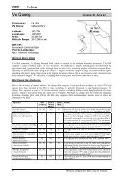
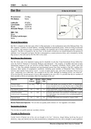
2. Site Features<br />
2.1 Biogeography<br />
According to <strong>the</strong> classification <strong>of</strong> MacKinnon (1996), <strong>Xuan</strong> <strong>Lien</strong> proposed nature reserve is located in<br />
sub-unit 10b (North Indochina) <strong>of</strong> <strong>the</strong> Indo-Chinese sub-region; and, according to <strong>the</strong> classification <strong>of</strong><br />
Wikramanayake et al. (1997), <strong>the</strong> proposed nature reserve is situated within <strong>the</strong> Nor<strong>the</strong>rn Indochina<br />
Subtropical Forests Ecoregion.<br />
2.2 Location<br />
<strong>Xuan</strong> <strong>Lien</strong> proposed nature reserve is located in Thuong <strong>Xuan</strong> district, Thanh Hoa province, and is<br />
bounded by <strong>the</strong> coordinates 19°52' to 20°02'N and 104°58' to 105°15'E (Map 1). The proposed<br />
nature reserve includes all or part <strong>of</strong> six communes: Bat Mot, Yen Nhan, <strong>Xuan</strong> Khao, <strong>Xuan</strong> <strong>Lien</strong>, <strong>Xuan</strong> My<br />
and Van <strong>Xuan</strong>.<br />
The proposed nature reserve is bordered by <strong>the</strong> Cao River to <strong>the</strong> north, <strong>the</strong> provincial border with<br />
Nghe An to <strong>the</strong> south and west, and <strong>the</strong> Ta Leo and Bu Khong mountains and <strong>the</strong> confluence <strong>of</strong> <strong>the</strong><br />
Cao and Chu Rivers to <strong>the</strong> east.<br />
2.3 Topography<br />
The proposed nature reserve is situated in a belt <strong>of</strong> mountains running from Sam Neua in Laos to<br />
Thuong <strong>Xuan</strong> and Nhu <strong>Xuan</strong> districts in Thanh Hoa province. These mountains contain many high<br />
peaks, such as Ta Leo (1,400 m), Bu Cho (1,563 m), Bu Hon Han (1,208 m), and an unnamed<br />
1,605 m peak. The topography <strong>of</strong> <strong>the</strong> nature reserve is characterised by low mountains, dissected by<br />
deep, narrow valleys.<br />
Two main topographic <strong>for</strong>ms dominate <strong>the</strong> area:<br />
(a) Medium High Mountains. Located at elevations <strong>of</strong> 800 to 1,600 m in <strong>the</strong> Cao and<br />
Nam Boo River basins, <strong>the</strong>se mountains are dissected by deep, narrow valleys, sloping<br />
from west to east. Slopes are steep, averaging 35°. These areas cover a total <strong>of</strong> 4,289 ha or<br />
18% <strong>of</strong> <strong>the</strong> study area.<br />
(b) Low Mountains and Foothills These areas are located at elevations below 800 m and lie<br />
mainly in <strong>the</strong> east, in <strong>the</strong> Cao River basin, and in <strong>the</strong> south, near <strong>the</strong> border with Nghe<br />
An province. Slopes in <strong>the</strong>se areas are generally shallower: on average 20 to 25° <strong>for</strong> <strong>the</strong><br />
low mountain areas and 15 to 20° <strong>for</strong> foothill areas. The topography is less complex<br />
than in <strong>the</strong> higher areas. These areas cover a total <strong>of</strong> 19,321 ha, representing 82% <strong>of</strong> <strong>the</strong><br />
study area.<br />
Several o<strong>the</strong>r topographic types also occur in <strong>the</strong> study area, though <strong>the</strong>y cover only small, scattered<br />
areas. Karsts occur at elevations below 800 m and may have extremely steep slopes (60 to 70°) with<br />
vertical cliffs in places. Access to <strong>the</strong>se areas is <strong>of</strong>ten difficult. The topography <strong>of</strong> valleys in <strong>the</strong> study<br />
area varies: valley floors are narrow in upstream areas, becoming wider in <strong>the</strong> lower sections <strong>of</strong> <strong>the</strong> Cao,<br />
Kue and Chu Rivers. Many <strong>of</strong> <strong>the</strong>se lower sections have relatively flat, fertile valleys.