BALTICA14 - KlaipÄdos universitetas
BALTICA14 - KlaipÄdos universitetas
BALTICA14 - KlaipÄdos universitetas

You also want an ePaper? Increase the reach of your titles
YUMPU automatically turns print PDFs into web optimized ePapers that Google loves.
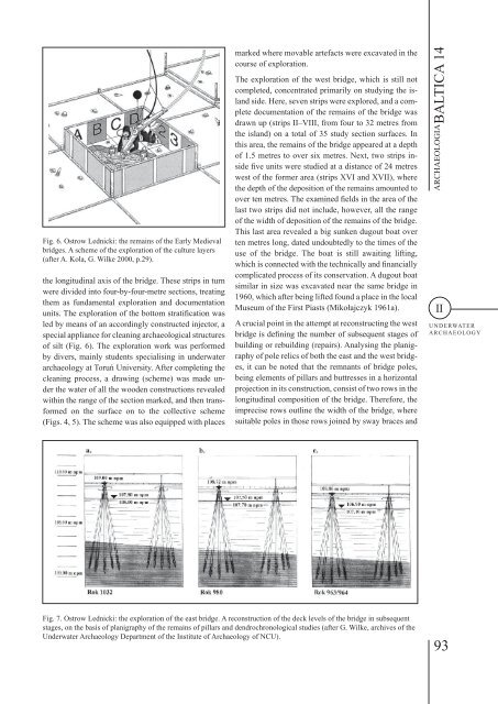
Fig. 6. Ostrow Lednicki: the remains of the Early Medieval<br />
bridges. A scheme of the exploration of the culture layers<br />
(after A. Kola, G. Wilke 2000, p.29).<br />
the longitudinal axis of the bridge. These strips in turn<br />
were divided into four-by-four-metre sections, treating<br />
them as fundamental exploration and documentation<br />
units. The exploration of the bottom stratification was<br />
led by means of an accordingly constructed injector, a<br />
special appliance for cleaning archaeological structures<br />
of silt (Fig. 6). The exploration work was performed<br />
by divers, mainly students specialising in underwater<br />
archaeology at Toruń University. After completing the<br />
cleaning process, a drawing (scheme) was made under<br />
the water of all the wooden constructions revealed<br />
within the range of the section marked, and then transformed<br />
on the surface on to the collective scheme<br />
(Figs. 4, 5). The scheme was also equipped with places<br />
marked where movable artefacts were excavated in the<br />
course of exploration.<br />
The exploration of the west bridge, which is still not<br />
completed, concentrated primarily on studying the island<br />
side. Here, seven strips were explored, and a complete<br />
documentation of the remains of the bridge was<br />
drawn up (strips II–vIII, from four to 32 metres from<br />
the island) on a total of 35 study section surfaces. In<br />
this area, the remains of the bridge appeared at a depth<br />
of 1.5 metres to over six metres. Next, two strips inside<br />
five units were studied at a distance of 24 metres<br />
west of the former area (strips XvI and XvII), where<br />
the depth of the deposition of the remains amounted to<br />
over ten metres. The examined fields in the area of the<br />
last two strips did not include, however, all the range<br />
of the width of deposition of the remains of the bridge.<br />
This last area revealed a big sunken dugout boat over<br />
ten metres long, dated undoubtedly to the times of the<br />
use of the bridge. The boat is still awaiting lifting,<br />
which is connected with the technically and financially<br />
complicated process of its conservation. A dugout boat<br />
similar in size was excavated near the same bridge in<br />
1960, which after being lifted found a place in the local<br />
Museum of the First Piasts (Mikołajczyk 1961a).<br />
A crucial point in the attempt at reconstructing the west<br />
bridge is defining the number of subsequent stages of<br />
building or rebuilding (repairs). Analysing the planigraphy<br />
of pole relics of both the east and the west bridges,<br />
it can be noted that the remnants of bridge poles,<br />
being elements of pillars and buttresses in a horizontal<br />
projection in its construction, consist of two rows in the<br />
longitudinal composition of the bridge. Therefore, the<br />
imprecise rows outline the width of the bridge, where<br />
suitable poles in those rows joined by sway braces and<br />
ARCHAEOLOGIA BALTICA 14<br />
II<br />
UNDERWATER<br />
ARCHAEOLOGY<br />
Fig. 7. Ostrow Lednicki: the exploration of the east bridge. A reconstruction of the deck levels of the bridge in subsequent<br />
stages, on the basis of planigraphy of the remains of pillars and dendrochronological studies (after G. Wilke, archives of the<br />
Underwater Archaeology Department of the Institute of Archaeology of NCU).<br />
93