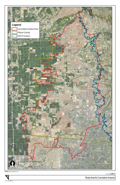
<strong>4.0</strong> Cumulative Impacts which contain a wide range of agricultural uses, from grazing and row corps to orchards, and contain soils that are similar to the project site. The study area for cumulative air quality impacts is the <strong>Sacramento</strong> Valley Air Basin, which includes Butte, Colusa, Glenn, <strong>Sacramento</strong>, Shasta, Sutter, Tehama, Yolo, and Yuba counties, the western urbanized portion of Placer County, and the eastern portion of Solano County. The study area for cumulative impacts on cultural resources is western Placer County because, to the extent that there are any pre-historic and historic resources within the project site, their significance is generally expected to be confined to the local area, and they are generally not expected to have a broader significance to the State of California. Therefore the cumulative impacts of the Proposed Action are not anticipated to cumulate with impacts of projects outside of western Placer County. The study area for cumulative effects to surface water hydrology and water quality is Curry Creek watershed within which the Proposed Action would be located. The cumulative context for effects to groundwater is the North American Groundwater Sub-basin. The cumulative context for noise depends on whether the source is mobile (traffic related) or stationary source related (factory, generator, etc.). Traffic from the Proposed Action would result in noise both inside and outside the project site. At the same time, the project site development would also be subjected to traffic noise associated with the development of other nearby areas. Consequently, the cumulative context for noise is southwestern Placer County. The study area for potential cumulative impacts related to provision of utilities is the service area for each utility district, including the service areas of City of Roseville and the Placer County Water Agency for water supply; the City of Roseville’s service area for wastewater, and the service area of the regional landfill for solid waste impacts. 4.2.4 Identification of Other Past, Present and Reasonably Foreseeable Future Actions and Projects As noted above, the timeframe selected for most of the resource topics addressed in this cumulative impact assessment is 40 years in the past to approximately 40 to 50 years in the future. Given this timeframe, the evaluation of past actions could not be based on a list of projects. However, two methods were used to analyze the changes in the study area due to historical agricultural practices and land development over the last 40 years. Firstly, the USACE conducted a review of historical aerial photographs to characterize the changes in land use patterns at a landscape scale. Secondly, USACE conducted a review of permits issued for projects within the study area between approximately 1990 and 2011 to characterize the changes in the study area with respect to the waters of the US. Furthermore, the conditions that exist in the project area at this time, which are reflective of the effects of past actions, were fully considered in the evaluation of cumulative impacts. Impact Sciences, Inc. <strong>4.0</strong>-4 Sierra Vista Specific Plan Draft EIS USACE #200601050 July 2012
Legend Cumulative Impact Area Placer County 200 ft Contour [ 0 1 2 4 Miles Aerial Photo: Bing Maps, 2011 SOURCE: Salix Consulting – 2011 FIGURE <strong>4.0</strong>-1 Study Area for Cumulative Impacts 1061-001•03/12