

Landslide - Geoscience Australia
Landslide - Geoscience Australia
Landslide - Geoscience Australia

Create successful ePaper yourself
Turn your PDF publications into a flip-book with our unique Google optimized e-Paper software.
Chapter Eight:<br />
<strong>Landslide</strong><br />
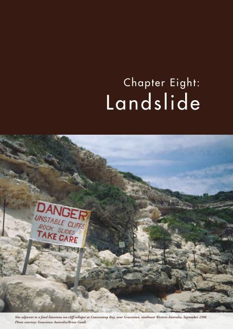
Site adjacent to a fatal limestone sea-cliff collapse at Cowaramup Bay, near Gracetown, southwest <strong>Landslide</strong> Western | Chapter <strong>Australia</strong>, xxx September | page 1996115<br />
Photo courtesy: <strong>Geoscience</strong> <strong>Australia</strong>/Brian Gaull.
<strong>Landslide</strong><br />
<strong>Landslide</strong>s regularly occur in localised areas across<br />
<strong>Australia</strong>, and pose a serious threat to people and<br />
property. They occur over a wide range of velocities and<br />
are often at their most damaging when they happen<br />
suddenly and without warning.<br />
The economic cost of individual landslide events is<br />
typically much lower than the cost of flood or earthquake<br />
events. Since 1842 there have been approximately 84<br />
known landslide events, collectively responsible for the<br />
deaths of at least 107 people and injury to at least<br />
141 people, as recorded in the <strong>Australia</strong>n <strong>Landslide</strong><br />
Database (GA 2007). Although many landslides have<br />
natural causes, well over half of the landslides that have<br />
caused death and injury can be attributed either directly<br />
or indirectly to human activity.<br />
Cracks in the retaining wall and road from landslide activity near<br />
the head of the Lawrence Vale landslides in Launceston, Tasmania<br />
Photo courtesy: <strong>Geoscience</strong> <strong>Australia</strong>/captured in 1996.<br />
Vehicles caught in the run-out of a debris flow on the Bulli Pass<br />
near Wollongong, New South Wales, August 1998<br />
Photo courtesy: NSW SES.<br />
State Emergency Service volunteers involved in rescue efforts at<br />
a fatal landslide at Thredbo, New South Wales, July 1997<br />
Photo courtesy: NSW SES.<br />
Damage to a road caused by a landslide at Macquarie Pass<br />
south of Wollongong, New South Wales, February 1997<br />
Photo courtesy: <strong>Geoscience</strong> <strong>Australia</strong>/Marion Leiba.<br />
page 116 | NATURAL HAZARDS IN AUSTRALIA | Identifying Risk Analysis Requirements
This chapter highlights the types of landslides<br />
which occur in <strong>Australia</strong>, and the factors which<br />
cause them. Information is provided on the<br />
risk analysis process and the data required<br />
for modelling. The basic theory of landslide<br />
processes is well understood. However, landslide<br />
risk assessments are complex and there are<br />
significant information gaps in undertaking<br />
landslide risk analyses which are outlined. The<br />
potential influences of climate change and the<br />
impact of climatic cycles on landslide processes<br />
remains a significant gap in information. The<br />
majority of landslide practitioners in <strong>Australia</strong><br />
are in the private sector, and local governments<br />
have principal responsibility for managing<br />
landslide risk.<br />
Hazard Identification<br />
<strong>Landslide</strong>s are a form of erosion known as<br />
‘mass wasting’, which is an important natural<br />
phenomenon in the formation of slopes and<br />
in the evolution of landscapes. The term<br />
‘landslide’, which encompasses a range of<br />
processes, is the term favoured by geotechnical<br />
professionals. Other terms such as ‘landslip’<br />
are entrenched in legal terminology, and the<br />
general public and media may use terms such<br />
as ‘slumps’ or ‘mudslides’.<br />
In simple terms, landslides occur when the<br />
downward force of gravity acting on slope<br />
materials exceeds the cohesive force that holds<br />
the soil particles together, or the frictional force<br />
which holds the material to the slope (i.e. ‘shear<br />
strength’). The failure of slope materials can be<br />
related to a number of contributing factors and<br />
trigger factors.<br />
The contributing or ‘site setting’ factors which<br />
influence whether a landslide will occur include:<br />
steepness of the slope; shape of the hillside;<br />
engineering properties of different materials in<br />
the subsurface profile; depth to the water table<br />
(or the pore water pressures on the landslide<br />
failure surface); the potential for subsurface water<br />
concentration; and vegetation cover.<br />
Often a number of factors will contribute to a<br />
landslide occurring. However, frequently the<br />
dominant factor which triggers the movement<br />
of slope material will be an increase in pore water<br />
pressure from rainfall or leaking infrastructure.<br />
Other triggers include earthquakes, vibrations<br />
caused by human activities, and undercutting of<br />
slopes by fluvial erosion or artificial excavation.<br />
Additional information is available in a range<br />
of texts, including Turner and Schuster (1996)<br />
and Fell (1992). The relationships between<br />
these factors are important in understanding<br />
the causes of landslides.<br />
All factors can be influenced either positively<br />
or negatively by human activity. Although in<br />
some areas landslides may be limited to failures<br />
in uncontrolled and unretained fill or road<br />
cuttings and excavations, they still pose a risk<br />
to people and property. Consequently, it is<br />
unusual to find a populated area in <strong>Australia</strong><br />
that is not susceptible to some form of landslide<br />
process. It is believed that all local government<br />
areas have land stability challenges of one form<br />
or another (Leventhal and Kotze in press).<br />
Fell (1992) provides a regional overview of<br />
land instability in <strong>Australia</strong>, which describes<br />
the location and extent of landslides and<br />
the conditions and mechanisms which are<br />
conducive to slope failure. Most landslides in<br />
<strong>Australia</strong> occur in Tertiary basalt, Tertiary and<br />
Cretaceous sediments and older inter-bedded<br />
sedimentary and coal measure formations (Fell<br />
1992). Maps which show the distribution of<br />
such materials for New South Wales, Victoria,<br />
southern Queensland and Tasmania, along with<br />
a comprehensive bibliography, are also provided<br />
in Fell (1992). Further information is provided<br />
by Johnson and others (1995), Michael-Leiba<br />
(1999), Michael-Leiba and others (1997), Blong<br />
and Coates (1987) and AGS (2007).<br />
<strong>Landslide</strong> | Chapter Eight | page 117
The distribution of reported landslide events<br />
in the <strong>Australia</strong>n landscape is shown in Figure<br />
8.1, which reflects the results of specific<br />
landslide mapping programmes based in<br />
Tasmania, southwest Victoria, Wollongong<br />
and Newcastle–Lake Macquarie in New South<br />
Wales, and Brisbane and Cairns in Queensland.<br />
The remainder of the landslides depicted were<br />
reported by the media or by ‘landslide spotters’.<br />
The types of landslides that occur in various<br />
geomorphic settings in <strong>Australia</strong> are<br />
explained below.<br />
Rockfall<br />
Typical settings where rockfalls may occur<br />
include cliffs in coastal zones, mountain sides,<br />
gorges, road cuttings or quarry faces. The coastal<br />
cliff lines of New South Wales (Kotze 2007)<br />
and the dolerite mountains of Tasmania are<br />
prominent examples. Rockfalls are characterised<br />
by an extremely rapid rate of movement and<br />
have been responsible for many of the landsliderelated<br />
deaths in <strong>Australia</strong>. Depending on local<br />
conditions, the run-out distances of rockfalls<br />
can be considerable. Although the source areas<br />
of these features are generally too steep to build<br />
upon, popular beaches and structures such as<br />
walking tracks, roads and houses may be located<br />
in the run-out area.<br />
The largest rockfall in <strong>Australia</strong>n history is<br />
believed to be a 30 million tonne rockfall<br />
which collapsed above the shoreline of the Lake<br />
Burragorang Reservoir (Warragamba Dam)<br />
in New South Wales in 1965; the rockfall was<br />
Darwin<br />
Alice Springs<br />
Brisbane<br />
Perth<br />
Adelaide<br />
Canberra<br />
Sydney<br />
0<br />
500 km<br />
Melbourne<br />
Hobart<br />
07-2256-9<br />
Figure 8.1: Recorded landslide events in <strong>Australia</strong><br />
Source: This map was compiled by <strong>Geoscience</strong> <strong>Australia</strong> in August 2007 from data available in the <strong>Australia</strong>n <strong>Landslide</strong><br />
Database (incorporating records from <strong>Geoscience</strong> <strong>Australia</strong>, Mineral Resources Tasmania and the University of Wollongong).<br />
Data for southwest Victoria were supplied by Corangamite Catchment Management Authority in association with the<br />
University of Ballarat and A.S. Miner Geotechnical.<br />
page 118 | NATURAL HAZARDS IN AUSTRALIA | Identifying Risk Analysis Requirements
attributed to underground coal mining (Pells<br />
and others 1987). Other examples include the<br />
rockfall at Gracetown, Western <strong>Australia</strong>, in<br />
1996, where 30 tonnes of rock and sand fell from<br />
a limestone sea cliff onto people sheltering under<br />
an overhang, injuring three and killing nine; a<br />
100 metre rockslide at Mulligans Bluff on the<br />
Gwydir Highway, New South Wales, in 2002;<br />
and regular rockfalls along Lawrence Hargrave<br />
Drive in Wollongong, New South Wales,<br />
including notable falls in 1988 and 2003.<br />
Deep-seated <strong>Landslide</strong><br />
Deep-seated landslides typically occur in steep<br />
terrain. However, they can be observed on slopes<br />
with angles as low as a few degrees, because<br />
the geological materials involved typically have<br />
low shear strength or are subject to high pore<br />
pressure. Areas include the Tertiary basalt soils<br />
and the Tertiary sediments of eastern <strong>Australia</strong><br />
(Fell 1992; McGregor and others 2007).<br />
Across <strong>Australia</strong>, there are many examples<br />
of houses and subdivisions built on existing<br />
landslide sites or on slopes that are susceptible to<br />
failure. While most of these landslide sites may be<br />
dormant, some can be reactivated with changes in<br />
pore water pressures and/or disturbance through<br />
human activities such as property development.<br />
An example of a deep-seated landslide in<br />
Tasmania is the Taroona <strong>Landslide</strong> in Hobart,<br />
a very to extremely slow-moving landslide on<br />
which two schools and nearly one hundred<br />
houses are located (Moon and McDowell 2002;<br />
Latinovic and others 2001). Monitoring over<br />
a seven-year period indicated that movement<br />
occurred at the site every year, although only a<br />
few structures were affected by the movement.<br />
Debris Flow<br />
Debris flows can originate on slopes in the range<br />
of approximately 16 to 40 degrees, where loose<br />
rock and soil materials are subjected to highintensity<br />
rainfalls. Where water content is high,<br />
debris flows can travel at rapid velocities with<br />
considerable destructive potential. Houses and<br />
other structures may be situated on or near the<br />
source area or run-out path of such features.<br />
The landslide at Thredbo, New South Wales,<br />
in 1997 became a debris flow which destroyed<br />
two buildings and claimed 18 lives. It was the<br />
worst landslide disaster in <strong>Australia</strong>n history,<br />
and the ground failure was attributed to a<br />
leaking water main.<br />
Debris flows triggered by intense rainfall include:<br />
the debris flow at Humphrey Rivulet, Tasmania,<br />
in 1972 (Mazengarb and others 2007); the slides<br />
which blocked the Captain Cook Highway<br />
behind Ellis Beach, north of Cairns, Queensland,<br />
in 1951 (Michael-Leiba and others 1999); and<br />
the 60,000 tonne debris flow at Montrose in the<br />
Dandenong Ranges of Victoria in 1891 (Moon<br />
and others 1992).<br />
Shallow <strong>Landslide</strong><br />
Shallow landslides occur in areas with a shallow<br />
layer of weak material and are often triggered<br />
by brief episodes of intense rainfall. They tend<br />
to occur on the edge of embankments and on<br />
steep natural slopes of 30 degrees or more. The<br />
infrastructure most commonly affected is roads<br />
and railway lines, although shallow landslides<br />
occasionally damage houses and other private<br />
property.<br />
Numerous shallow landslides occur during the<br />
wet season. For example, they are often associated<br />
with tropical cyclones in the Cairns region and<br />
along the Cairns–Kuranda railway (Michael-<br />
Leiba and others 1999).<br />
Cost of <strong>Landslide</strong>s<br />
The financial and social consequences posed<br />
by landslides are extremely underestimated<br />
in <strong>Australia</strong>. <strong>Landslide</strong>s regularly damage<br />
buildings, roads, railways, vehicles, pipelines<br />
and communication lines, and have adverse<br />
social effects that include death, injury, stress<br />
<strong>Landslide</strong> | Chapter Eight | page 119
Damage to a road caused by a slow moving landslide at Pleasant Hills, northwest of Launceston, Tasmania<br />
Photo courtesy: <strong>Geoscience</strong> <strong>Australia</strong>/Marion Leiba/captured in 1996.<br />
and displacement. Not only is stress detrimental<br />
from the psychological and social point of view,<br />
it also can have detrimental physical effects that<br />
may even lead to fatalities.<br />
The total direct cost of landslides in <strong>Australia</strong><br />
for the period from 1967 to 1999 is estimated<br />
at $40 million. This can be solely attributed to<br />
the 1997 Thredbo landslide as only landslides<br />
costing $10 million or over were included in the<br />
BTE (2001) estimate. However, for the period<br />
from 1900 to 1999 the total socioeconomic cost<br />
of landslides was estimated at $500 million in<br />
1998 dollars (EMA 1999).<br />
Most damage is the result of many small landslide<br />
events, and it is believed they have a significant<br />
cumulative cost. Few insurance policies in<br />
<strong>Australia</strong> cover landslides, and it is understood<br />
that the majority of landslide costs are absorbed<br />
directly by individual property owners as well as<br />
by infrastructure authorities.<br />
Costs associated with disaster assistance and<br />
road maintenance, relocation and repair are<br />
among the greatest public costs resulting from<br />
landslides. For example, the <strong>Australia</strong>n <strong>Landslide</strong><br />
Database indicates that the construction cost of<br />
diverting the Lawrence Hargrave Drive coastal<br />
route around a cliff face subject to rockfalls was<br />
$49 million in 2006 dollars, and it is estimated<br />
that from 1989 to 1996 the cost of repairs to<br />
railway infrastructure in Wollongong amounted<br />
to $175 million. Reconstruction of the Alpine<br />
Way after the Thredbo landslide cost $24 million<br />
(BTE 2001).<br />
Adding to the complexities of estimating<br />
landslide costs are the different types of landslide<br />
processes. The costs of extremely slow-moving<br />
landslides which cause cracks or irregularities in<br />
the fabric of buildings and in the surface of roads,<br />
footpaths or pipelines are typically absorbed into<br />
general maintenance and repair costs. Other<br />
hazards, such as tropical cyclone or flood, may<br />
trigger landslides, presenting a challenge in<br />
isolating and determining the damage that is a<br />
specific consequence of the landslide.<br />
Environmental cost is difficult to quantify in<br />
financial terms. <strong>Landslide</strong>-derived sediment may<br />
cause prolonged turbidity in stream channels<br />
that, in turn, may adversely impact on water<br />
reservoirs or fish habitats. A significant increase in<br />
the incidence of landslides on Macquarie Island,<br />
Tasmania, is believed to be the consequence of<br />
the removal of vegetation by a rapidly expanding<br />
population of rabbits. Costs of controlling the<br />
rabbit numbers and preventing further landslides<br />
are estimated to be $24.6 million (ABC 2007;<br />
Parks and Wildlife Service 2007).<br />
Further information on the economic and social<br />
impact of landslides in <strong>Australia</strong> is provided by<br />
Blong and Eyles (1989), Schuster (1996), and<br />
Michael-Leiba (1999).<br />
page 120 | NATURAL HAZARDS IN AUSTRALIA | Identifying Risk Analysis Requirements
Potential Influence of<br />
Climate Change<br />
In geological time, climate change has been<br />
extensive and has had a profound influence on<br />
sea level, rainfall patterns, and temperaturerelated<br />
hillside processes such as chemical and<br />
mechanical weathering. Climatic phenomena,<br />
such as the complex interactions of the<br />
Interdecadal Pacific Oscillation Index, the El<br />
Niño–Southern Oscillation (ENSO) and the<br />
deep-ocean conveyor cycle, have impacted on<br />
the short-term and long-term rates of mass<br />
wasting in <strong>Australia</strong>, which span from decades<br />
to thousands of years and longer. Further<br />
information on these interactions is available in<br />
Kiem and others (2006).<br />
Rainfall patterns are significant to landslide<br />
occurrence. Conceptually, it is almost a certainty<br />
that predicted climate change will impact on<br />
the rate and severity of landslide hazard to some<br />
degree. More frequent high-intensity rain in<br />
some areas could be expected to increase the<br />
likelihood of landslides and erosion, particularly<br />
in the urbanised catchments on <strong>Australia</strong>’s east<br />
coast (CSIRO 2002).<br />
Potential impacts of climate change include<br />
increases in sea level and temperature and a drier<br />
climate.<br />
A rise in global sea level in the order of 0.09–0.88<br />
metres by 2100 (Solomon and others 2007) will have<br />
an influence on <strong>Australia</strong>’s coastal environments,<br />
accelerating the erosion of sandy dunes along soft<br />
coasts and cliffs along hard coasts.<br />
A drier climate will lead to a drawdown of the<br />
water table, and may reduce the likelihood<br />
of deep-seated landslides, debris flows and<br />
intermittent slip-stick movement. For instance,<br />
a marked drop in annual rainfall from 1975 to<br />
1976 was reflected in a drop in landslide activity<br />
in Tasmania (Ezzy and Mazengarb 2007).<br />
However, in areas with shallow slopes of reactive<br />
clay soils, a lowering of the water table may<br />
cause ‘fissuring’ (i.e. cracking) on slopes. This<br />
may increase the susceptibility of the slopes to<br />
water infiltration during rainfall, which can lead<br />
to slope failure.<br />
An increase in temperature is likely to bring<br />
more frequent and intense storms. Storms<br />
accompanied by heavy rainfall may trigger<br />
landslides and short-duration erosion. Stream<br />
flow from increased run-off may also accelerate<br />
erosion rates and undercut slopes. An example<br />
of the relationships between intense storms<br />
and increased stream flow and shallow slides<br />
and debris flows is provided by Reinfields and<br />
Nanson (2001).<br />
Guidelines for responding to the effects of<br />
climate change in coastal and ocean engineering<br />
are outlined in Engineers <strong>Australia</strong> (2004).<br />
Risk Analysis<br />
<strong>Landslide</strong> risk analysis involves determining the<br />
likelihood of a particular landslide event and<br />
understanding the possible consequences of that<br />
event. The data required to model or map actual<br />
and potential landslides vary with the scale<br />
and purpose of the assessment. Modelling of<br />
landslide susceptibility, hazard and risk requires<br />
the existence of a landslide inventory, which is<br />
the fundamental source of historic information<br />
on landslide occurrence and is used to validate or<br />
‘ground truth’ any models which are built.<br />
A variety of skills are required to perform a<br />
landslide risk analysis, and the number of<br />
personnel involved might range from a single<br />
individual for a house site analysis to a team for<br />
a regional analysis.<br />
The practice of landslide risk analysis is a<br />
requirement for a range of activities, including<br />
infrastructure development, mining, monitoring<br />
and maintenance (e.g. for hydroelectric dams<br />
<strong>Landslide</strong> | Chapter Eight | page 121
and roads), and as a condition for development<br />
approval imposed by local government. It is<br />
important to note that the mining sector is an<br />
area where an advanced understanding of soil<br />
and rock behaviour is critical to ensuring safe<br />
working conditions. This specialised area is<br />
outside the scope of this chapter, though is an<br />
area where the principles of risk management are<br />
routinely applied.<br />
Prior to the 1997 Thredbo disaster, the general<br />
public regarded the issue of landslide risk to be<br />
primarily related to loss of property (Leventhal<br />
and Kotze in press). The Thredbo landslide<br />
changed public and political perception of the<br />
hazard, and led to the formulation of guidelines<br />
for practitioners by the <strong>Australia</strong>n Geomechanics<br />
Society (AGS). The suite of guidelines outlines<br />
good practice in landslide susceptibility, hazard<br />
and risk zoning for land use planning (AGS<br />
2007a; AGS 2007b), landslide risk management<br />
(AGS 2007c; AGS 2007d) and slope management<br />
and maintenance (AGS 2007e).<br />
Despite the guidance offered by the AGS, there<br />
remain variations in the approach to landslide<br />
risk analysis within <strong>Australia</strong>. Some practitioners<br />
find it difficult to achieve the desired standard,<br />
for reasons such as complexity and cost. A<br />
landslide risk assessment is a complex and<br />
difficult process (van Westen and others 2005)<br />
and methods are still evolving. Assessments are<br />
increasingly becoming multidisciplinary and<br />
technology driven.<br />
Further information on risk analysis and<br />
assessment is provided by Cruden and Fell (1997),<br />
Hungr and others (2005), Miner and Dalhaus<br />
(2006), Flentje and others (2005), Flentje and<br />
others (2007), and Lee and Jones (2004); and in<br />
the reference lists of the AGS guidelines and van<br />
Westen and others (2005). Further information<br />
on the role of the AGS guidelines is provided in<br />
Leventhal and Kotze (in press), Leventhal (2007)<br />
and Leventhal and others (2007).<br />
Likelihood Analysis<br />
Since the adoption of a risk-based approach<br />
to landslide assessment in recent years, the<br />
estimation of landslide likelihood has proven<br />
to be particularly challenging. Estimations of<br />
likelihood are evolving from the use of relative<br />
terms such as ‘possible’ and ‘unlikely’ to semiquantitative<br />
and quantitative approaches (e.g.<br />
Moon and Wilson 2004, and Moon and others<br />
2005). Estimating potential movement of an<br />
existing landslide is difficult, but predicting a firsttime<br />
slide is even harder. This is partly because<br />
records of past events are invariably incomplete<br />
and provide little guidance on infrequent events<br />
(Moon and others 2005).<br />
There are at least three distinctly different<br />
landslide processes that need to be considered<br />
(i.e. rockfall, debris flow and deep-seated<br />
landslides), as well as the range of triggering<br />
and contributing factors, which may be poorly<br />
understood regionally and/or locally. Each type<br />
of landslide varies in frequency, speed and style<br />
of movement, duration and run-out distance,<br />
and has unique properties and characteristics<br />
for risk analysis and management. Additionally,<br />
for each different type of landslide process the<br />
risk analysis needs to take into consideration<br />
potential effects up-slope, down-slope, laterally<br />
and in the run-out zone.<br />
The estimation of likelihood is a two-stage<br />
procedure for each landslide type. The first<br />
stage generates a landslide susceptibility map,<br />
and incorporation of the second stage generates<br />
a landslide hazard map. Each type of landslide<br />
needs to be analysed separately in these stages, as<br />
each is governed by a different physical process.<br />
The first stage of analysing likelihood is to<br />
determine the susceptibility of landslides, which is<br />
a measure of the ‘spatial probability’ of failure. This<br />
stage considers any historic landslide occurrence<br />
and analyses the underlying site setting factors<br />
page 122 | NATURAL HAZARDS IN AUSTRALIA | Identifying Risk Analysis Requirements
which contribute to landslides. For all three<br />
landslide processes, susceptibility analysis involves<br />
the identification of potential source areas, as well<br />
as the separate prediction of potential landslide<br />
run-out areas. Both procedures can be done in<br />
several ways using various modelling and mapping<br />
techniques. These are outlined in AGS (2007a;<br />
2007b) and Flentje and others (2007).<br />
The second stage is to determine ‘temporal<br />
probability’. There are several approaches, as<br />
outlined in van Westen and others (2005).<br />
The temporal probability can be obtained by<br />
correlating the data on landslide occurrence with<br />
data on the triggering factors, provided data<br />
records are sufficient, or through dynamic (i.e.<br />
time dependant) modelling (van Westen and<br />
others 2005).<br />
For example, long-term record keeping of<br />
landslide events can allow the relationship of<br />
landslide occurrence to triggering events such<br />
as rainfall to be determined (Michael-Leiba<br />
and others 2002; Walker 2007), although this<br />
relationship may not always be clear (MacGregor<br />
and others 2007). Rainfall analysis may require<br />
consideration of duration (e.g. antecedent values<br />
over weeks and months) and intensity (e.g. over<br />
a 24-hour period or shorter event), depending<br />
upon the style of landslide. The likelihood of<br />
failure can then be derived for any point on the<br />
ground by analysing the number of landslides<br />
per year, and their susceptibility, combined with<br />
the predicted recurrence interval of the rainfall<br />
conditions which trigger the landslides.<br />
Additionally, based on observed relationships<br />
in nature whereby smaller events tend to occur<br />
more often than larger events, the analysis of<br />
magnitude–frequency relationships may further<br />
refine the likelihood modelling of event size.<br />
Data requirements<br />
The information required will vary depending<br />
on the type, scale and purpose of investigation.<br />
Likelihood analysis requires data to estimate the<br />
spatial and temporal probability of landslides<br />
(i.e. the landslide hazard map).<br />
The historic information on landslide events<br />
is fundamental, as it provides an insight into<br />
the frequency of the phenomena, the types of<br />
landslides involved, the volumes of materials<br />
involved, and the damage caused (van Westen<br />
and others 2005). The data should span as<br />
lengthy a time as possible and include landslide<br />
View from the headscarp of a fatal landslide at Thredbo, New South Wales, July 1997<br />
Photo courtesy: <strong>Geoscience</strong> <strong>Australia</strong>.<br />
<strong>Landslide</strong> | Chapter Eight | page 123
Homes perched precariously after a major landslide on Currumbin Hill, southeast Queensland, July 2005<br />
Photo courtesy: Emergency Management Queensland.<br />
inventories, aerial photographs, remote-sensing<br />
data and terrestrial photography.<br />
Historic data on landslide occurrence, in<br />
addition to the site setting factors, are important<br />
in determining landslide susceptibility. This<br />
generally requires data on topography, geology,<br />
geomorphology, soil type, soil depth, geotechnical<br />
characterisation of slope materials, vegetation,<br />
hydrology and hydrogeology. Such data, where<br />
available, are typically represented spatially<br />
as data ‘layers’ and analysed in a geographic<br />
information system (GIS). For example, a digital<br />
elevation model is important for modelling the<br />
run-out distance for landslides of a given type<br />
and volume.<br />
Incorporation of data on trigger factors is<br />
required to develop a landslide hazard map.<br />
This includes the data required to determine<br />
landslide susceptibility; rainfall data sets (both<br />
raw and derivative interpretations); data on<br />
seismic hazard; and other trigger information,<br />
which may include the location and type of<br />
underground pipes.<br />
High-resolution data are essential for undertaking<br />
likelihood analyses in localised regions. In<br />
some cases, the absence of spatial information<br />
may be replaced with the requirement for the<br />
practitioner to have sufficient understanding<br />
of the slope-forming processes operating in a<br />
particular area and the effects that individual<br />
components contribute to slope instability.<br />
Competent and skilled practitioners must be<br />
involved in the interpretation.<br />
Consequence Analysis<br />
The consequence of a landslide changes with<br />
temporal and thematic variations in vulnerability.<br />
For example, thematic variations include the<br />
material type of a building or the age distribution<br />
of a population. The estimation of the degree<br />
of damage should be based on vulnerability/<br />
fragility curves derived from historical damage<br />
inventories, where records are sufficient. Curves<br />
can also be derived from structural modelling<br />
or though empirical relations (van Westen and<br />
others 2005).<br />
The exposure of mobile elements such as people<br />
and vehicles will vary considerably between<br />
day and night, and seasonally, depending on<br />
where people work and reside. The vulnerability<br />
of elements which are at risk may also vary<br />
considerably depending on the type of<br />
landslide and its rate of movement (Cruden<br />
and Varnes 1996). Typically, the faster a<br />
landslide moves, the greater the amount of<br />
damage to people and property, because speed<br />
reduces the opportunity for remedial action or<br />
escape. However, even buildings situated on<br />
extremely slow landslides may be completely<br />
destroyed over a number of years.<br />
page 124 | NATURAL HAZARDS IN AUSTRALIA | Identifying Risk Analysis Requirements
For landslides with potentially long run-out<br />
lengths, the destructive potential will be strongly<br />
influenced by topography, slope angle and<br />
obstacles such as forests, as well as the shape,<br />
dimensions and mass of the boulders.<br />
Data requirements<br />
Data on historic damages for different landslide<br />
types and volumes and information on the<br />
vulnerability of the elements at risk are required.<br />
Generic exposure databases may be utilised,<br />
although these are better suited to hazards<br />
which impact regionally per event (e.g. flood<br />
or earthquake) rather than for landslides which<br />
generally impact isolated elements (van Westen<br />
and others 2005).<br />
Information Gaps<br />
Worldwide, much is known about landslide<br />
processes and the potential consequences of<br />
the range of landslide phenomena. However,<br />
for most of <strong>Australia</strong> there is no ready source<br />
of landslide information relating to the local<br />
setting and <strong>Australia</strong> does not have a good<br />
understanding of how its population centres<br />
relate to landslide risk.<br />
There is no coordinated means of data collection<br />
in <strong>Australia</strong>. Where such information exists,<br />
landslide mapping and geotechnical reporting<br />
is highly variable in standard and quality, and<br />
there is generally apprehension about sharing<br />
any information which may relate to potential<br />
issues of legal liability. There is also space to<br />
better consolidate and integrate geotechnical<br />
engineering expertise with research from<br />
domains of geology, geomorphology, hydrology,<br />
meteorology, GIS, and computation.<br />
The primary constraints to addressing landslide<br />
research gaps are skill shortages and resource<br />
limitations. There are currently no universities<br />
within <strong>Australia</strong> that teach the holistic range<br />
of skills required to undertake landslide risk<br />
analyses. Very few engineering departments<br />
teach or research engineering geology or geology<br />
for engineers. Furthermore, it is estimated that<br />
30,000 engineers will retire by the end of the<br />
next decade (Engineers <strong>Australia</strong> 2005). Skill<br />
shortages are particularly apparent in the civil<br />
sector, partly because of competition for skills<br />
from the lucrative mining sector.<br />
Further information on gaps in landslide<br />
knowledge and processes is provided in van<br />
Westen and others (2005) and Leventhal and<br />
Kotze (in press).<br />
<strong>Landslide</strong> Inventories<br />
The AGS (2007a; 2007b) considers that landslide<br />
information should be entered into inventories<br />
to underpin all successive risk analyses, research<br />
and land use decisions. The ongoing collection<br />
and analysis of landslide data and related data is a<br />
vital exercise, although the provision of funding<br />
for ongoing maintenance of these databases<br />
presents a challenge.<br />
A landslide inventory represents a fundamental<br />
base of knowledge for land use planning that<br />
strongly helps local authorities in their decision<br />
making. With few exceptions throughout<br />
<strong>Australia</strong>, the activity of recording landslides<br />
is currently undertaken in a haphazard way,<br />
and records are not detailed enough to be used<br />
confidently in probability assessments. Data are<br />
collected and recorded in different formats and<br />
cannot be compared or aggregated easily with other<br />
sources. The <strong>Landslide</strong> Database Interoperability<br />
Project being coordinated by <strong>Geoscience</strong> <strong>Australia</strong><br />
is a first step toward addressing this information<br />
gap (Osuchowski 2006).<br />
Additionally, throughout <strong>Australia</strong> geotechnical<br />
investigations are occurring as routine activities<br />
performed by councils within their development<br />
approval processes. The councils retain a great<br />
deal of detailed information on the landslides<br />
<strong>Landslide</strong> | Chapter Eight | page 125
in their municipalities, although the data are<br />
difficult to retrieve once they have been lodged<br />
with a regulator. There is seldom incorporation<br />
of, or reference to, these geotechnical reports in<br />
landslide databases and landslide information is<br />
rarely synthesised across multiple jurisdictions.<br />
If this information was made easily accessible<br />
to those who undertake risk analysis, it could<br />
significantly improve the availability of the basic<br />
knowledge required to assess landslide frequency<br />
and occurrence. Additionally, successive<br />
investigations in one vicinity would be able to<br />
build on previous research.<br />
<strong>Landslide</strong> Susceptibilty Mapping<br />
The distribution of landslides in the <strong>Australia</strong>n<br />
landscape is not well known. There has never<br />
been a national landslide susceptibility or hazard<br />
(likelihood) mapping programme, and only<br />
limited nationwide studies of landslides have<br />
been conducted.<br />
It is difficult to assess landslide susceptibility on a<br />
national scale, because landslides are dependent<br />
on the interaction of localised conditions, and<br />
methods to overcome the data limitations<br />
are still being developed. <strong>Landslide</strong> mapping,<br />
when conducted, generally occurs only on a<br />
site-specific scale and is performed by geotechnical<br />
consultants for purposes of zoning, building<br />
infrastructure or applying for development<br />
approvals.<br />
The regional susceptibility mapping of areas<br />
prone to landslides is not commonly undertaken<br />
in <strong>Australia</strong>. Without regional mapping, it is<br />
difficult for those with regulatory responsibilities<br />
to be aware of any landslide risks within their<br />
jurisdictions and target areas for detailed mapping.<br />
Examples are provided in Ezzy and Mazengarb<br />
(2007), Miner and Dalhaus (2006), and in a<br />
Victorian Government report regarding the Alpine<br />
Resorts Planning Scheme (DSE 2007a).<br />
First-pass landslide susceptibility maps are<br />
needed, particularly across areas with known<br />
histories of landslide occurrence. The limitations<br />
of the mapping and the levels of accuracy need to<br />
be made explicit on such maps.<br />
The availability of relevant datasets, such as<br />
geomorphology at scales of 1:25,000 or better,<br />
is highly variable throughout the country, even<br />
when considering the major urban areas. Highresolution<br />
data are essential for undertaking<br />
susceptibility, hazard and risk analyses in<br />
localised regions.<br />
Fundamental research directed at better<br />
understanding landslide processes in the<br />
<strong>Australia</strong>n setting is currently very limited.<br />
There are also significant geomorphic research<br />
gaps which include measuring the age of <strong>Australia</strong>’s<br />
landscape and developing landscape evolution<br />
models which can contribute significantly to<br />
better appreciation of slope-forming processes<br />
and their associated process rates.<br />
<strong>Landslide</strong> Hazard Mapping<br />
The primary constraint to hazard mapping is<br />
a lack of good inventory maps and validated<br />
inventory databases, in addition to resource<br />
constraints.<br />
There is a need for systematic and standardised<br />
landslide hazard assessments throughout the<br />
country, in order to assist stakeholders, such as<br />
regulators, to be aware of landslide hazards and<br />
to make informed land use decisions. Emergency<br />
management agencies would also benefit from<br />
acquiring a more technical understanding of<br />
landslide hazard areas to inform the development<br />
of emergency action plans.<br />
Determining temporal probability is often not<br />
possible, because of the absence of historical<br />
landslide records which can be related to the<br />
historical records of triggering events, the<br />
scarcity of input data, or the insufficient length<br />
of historical records of triggering events (van<br />
page 126 | NATURAL HAZARDS IN AUSTRALIA | Identifying Risk Analysis Requirements
Westen and others 2005). Determining the<br />
cumulative effects of human influence is difficult,<br />
particularly in urbanised areas susceptible to<br />
landslides.<br />
Ongoing analysis of the influence of triggering<br />
factors, such as rainfall events, on representative<br />
and problematic landslides in <strong>Australia</strong> is<br />
needed. Monitoring programmes, including the<br />
use of near real-time technologies, can provide<br />
information on the relationships of landslide<br />
movements to triggers. This is important if<br />
public safety warning systems are to be developed<br />
as part of risk management and disaster plans.<br />
At the local and regional levels, there is a need<br />
for research programmes that determine the<br />
relationships of contributing factors to landslide<br />
occurrence, magnitude–frequency rules and<br />
run-out limits for representative areas across<br />
<strong>Australia</strong>. As a strategic exercise, in the absence<br />
of national mapping strategies, this would<br />
provide context for site-specific investigations<br />
and other regional mapping exercises. Coupled<br />
with this aspect is the ongoing development of<br />
methods for implementation in applications<br />
such as landslide zoning.<br />
Influence of Climate Change<br />
The influence of climate change on landslides<br />
in <strong>Australia</strong> is not being specifically addressed<br />
by any agency. The effects of climate change on<br />
the frequency and intensity of rainfall triggers,<br />
as well as the impacts of rising sea level,<br />
need research.<br />
Further research is also needed on the differences<br />
between a changing climate and ‘climate change’,<br />
climate mechanisms which deliver high-risk<br />
periods, and ways in which human activities<br />
complicate the interactions of climate cycles.<br />
This includes better understanding the<br />
relationships between fossil landslides and the<br />
climate at the time of failure. This would allow a<br />
picture of prehistoric landslides and their causes<br />
to be developed, analogous to the process of<br />
identifying and dating fault scarps formed during<br />
The aftermath of a debris flow damaging a resort on Magnetic Island, January 1998<br />
Photo courtesy: <strong>Geoscience</strong> <strong>Australia</strong>/Marion Leiba.<br />
<strong>Landslide</strong> | Chapter Eight | page 127
State Emergency Service volunteers involved in rescue efforts at a fatal landslide at Thredbo, New South Wales, July 1997<br />
Photo courtesy: <strong>Geoscience</strong> <strong>Australia</strong>.<br />
large prehistoric earthquakes. This is important,<br />
as decadal cycles influence the activity of deepseated<br />
failures and raise issues with likelihood<br />
prediction.<br />
Roles and Responsibilities<br />
The majority of landslide practitioners in <strong>Australia</strong><br />
are in the private sector; considerably smaller<br />
numbers are in universities or state government<br />
agencies. The roles and responsibilities of those<br />
involved in managing parts of landslide risk are<br />
described below.<br />
<strong>Australia</strong>n Government<br />
The <strong>Australia</strong>n Government’s overarching goal<br />
in the management of landslide risk is to ensure<br />
the development of safer communities. The<br />
<strong>Australia</strong>n Government offers some financial<br />
assistance for landslide studies and landslide<br />
mitigation measures, through its funding<br />
programmes aimed at reducing the risk of natural<br />
disasters. It maintains the <strong>Australia</strong>n <strong>Landslide</strong><br />
Database and provides overarching emergency<br />
management and land use planning guidelines.<br />
The <strong>Australia</strong>n Government plays a role in<br />
raising awareness of landslide hazard though<br />
education and training programmes (EMA<br />
2001a; EMA 2001b), and contributes to<br />
innovative research to assist the mining industry<br />
through the development of models which assess<br />
the geotechnical stability of artificial slopes.<br />
The <strong>Australia</strong>n Government also underpins<br />
and coordinates a number of intergovernmental<br />
organisations and groups, particularly those<br />
directed to planning and building codes, such as<br />
the Development Assessment Forum.<br />
State and Territory Governments<br />
Legislation varies across states and territories<br />
in <strong>Australia</strong>; some have stronger legislative<br />
requirements than others. Current <strong>Australia</strong>n<br />
legislative controls are outlined in ABCB (2006),<br />
Leventhal and Kotze (in press) and Tefler (1988).<br />
State and territory governments differ in their<br />
approaches to managing landside hazards. Some<br />
have accepted the AGS (2007) predecessor<br />
<strong>Landslide</strong> Risk Management Concepts and<br />
Guidelines (AGS 2000) as an industry reference<br />
paper within legislation. All play an important<br />
role in strengthening partnerships with local<br />
governments, and in encouraging and supporting<br />
them to undertake disaster risk assessments and<br />
mitigation measures.<br />
All state and territory governments, with the<br />
exception of the Tasmanian Government, delegate<br />
responsibility to their local governments. Mineral<br />
Resources Tasmania is the only state government<br />
agency that undertakes regional mapping of<br />
landslides, maintains a state-wide landslide<br />
database, and provides landslide information to<br />
page 128 | NATURAL HAZARDS IN AUSTRALIA | Identifying Risk Analysis Requirements
the public. Mapping is generally undertaken by<br />
the private sector in other jurisdictions.<br />
Planning agencies in each state and territory<br />
develop coastal policies and landslide or erosion<br />
policies (EMA 2001a; DAF 2007). However,<br />
it is believed that some erosion policies do not<br />
specifically relate to landslide hazard, which<br />
can result in confusion among land owners and<br />
members of the general public. One example is<br />
the Erosion Management Overlay in Victoria<br />
(Golder Associates 2004; DSE 2007b).<br />
Road and rail transport agencies have<br />
a responsibility to protect road and rail<br />
infrastructure against landslides and to ensure<br />
construction does not increase landslide hazard.<br />
They do this by liaising strongly with geotechnical<br />
consultants.<br />
Local Government<br />
The majority of mitigation and development<br />
controls for slope management are achieved at<br />
the local government level (Leventhal and Kotze<br />
in press). Most landslide work is also undertaken<br />
at this level, with the private sector providing<br />
advice and support.<br />
Local governments have principal responsibility<br />
for systematically taking proper account of risk<br />
assessments in land use planning to reduce<br />
landslide risk. Local government agencies are<br />
responsible for reducing landslide losses using<br />
the best information available (COAG 2004).<br />
Zoning and planning schemes across local<br />
government are variable across jurisdictions<br />
within each state and territory. Some local<br />
governments designate ‘landslide hazard<br />
zones’ which control development within their<br />
jurisdictions, while others have not recognised<br />
or planned for landslide-related risk (Leventhal<br />
and Kotze in press).<br />
While guidance is provided by the Development<br />
Assessment Forum (DAF 2007), systematic<br />
policy implementation to address landslide<br />
hazard is rare across local governments.<br />
Local governments also have a regulatory<br />
responsibility, and regulatory approaches vary<br />
widely. There are no requirements for building<br />
constructions with the capability to withstand<br />
a landslide; regulatory control is currently<br />
directed toward preventing exposure to landslides<br />
(Leventhal and Kotze in press). A number<br />
of parties are involved in the landslide risk<br />
management process, although pragmatically the<br />
regulator sets the tolerable risk levels. Regulators<br />
need to appreciate the complexities of landslide<br />
risk analysis in order to ascertain the rigour of<br />
any geotechnical landslide reports upon which<br />
they base their decisions. The regulator is best<br />
placed to act in the interests of the community<br />
with respect to landslide hazard, particularly for<br />
matters relating to transfer of risk upon sale of<br />
properties.<br />
Industry, Coordinating Groups,<br />
Professional Bodies and Research<br />
Institutions<br />
There are a number of professional bodies<br />
and industry bodies that play an advocacy and<br />
leadership role in landslide risk management.<br />
Most function at a national scale: for example,<br />
Engineers <strong>Australia</strong> and the <strong>Australia</strong>n Building<br />
Codes Board. The National Engineering<br />
Registration Board recognised the challenges<br />
some regulators face and developed a<br />
‘specific area of practice’ within the National<br />
Professional Engineering Register for landslide<br />
risk management.<br />
Professional societies help to integrate the<br />
engineering and geotechnical science into<br />
decision making. They serve as conduits of<br />
information from researchers to practitioners.<br />
They are the source of codes and handbooks<br />
<strong>Landslide</strong> | Chapter Eight | page 129
A fatal landslide at Paluma Road, north of Townsville, Queensland, March 1997<br />
Photo courtesy: <strong>Geoscience</strong> <strong>Australia</strong>/Marion Leiba.<br />
which provide best practice guidance, and some<br />
also offer professional training. For example, the<br />
<strong>Australia</strong>n Building Codes Board identified that<br />
construction in areas prone to potential landslide<br />
hazard was an issue that requires consistent<br />
uniform guidance across the nation, and<br />
published a non-mandatory guideline (ABCB<br />
2006) to provide advice on this matter.<br />
Numerous geotechnical and engineering<br />
consulting companies are involved in landslide<br />
hazard and risk assessment on behalf of<br />
government and non-government agencies.<br />
Many conduct landslide research, develop<br />
landslide mapping and monitoring techniques<br />
and maintain their own landslide inventories.<br />
Engineering geologists, geotechnical engineers<br />
and building professionals provide geotechnical<br />
advice to government, business, industry and<br />
private property owners. They make a significant<br />
contribution to the development of methods, for<br />
example in undertaking landslide risk assessments<br />
for property developers and addressing legal<br />
liability in slope stability assessments.<br />
The University of Wollongong undertakes<br />
research encompassing landslide risk<br />
management, the development of GIS-based<br />
mapping techniques (Flentje and others 2007)<br />
and continuous real-time monitoring. The<br />
monitoring stations are facilitating quantitative<br />
landslide frequency assessments and providing<br />
real-time warning capabilities. The university<br />
works cooperatively with the Wollongong City<br />
Council, the local office of the New South Wales<br />
Roads and Traffic Authority and RailCorp. It is<br />
known that other universities undertake landslide<br />
research programmes although it is believed that<br />
this occurs on an ad hoc basis.<br />
Property Developers<br />
Developers are required to prepare development<br />
applications which address councils’ provisions<br />
relating to development in areas susceptible to<br />
landslides. The developer is required to provide<br />
a geotechnical assessment of the site which<br />
demonstrates that the development proposal<br />
takes into account appropriate mitigation<br />
techniques, and to seek advice from qualified<br />
engineering geologists and geotechnical<br />
engineers on site slope instability as part of that<br />
assessment. A qualified geotechnical professional<br />
may assess the reliability of these reports in<br />
landslide-prone areas.<br />
AGS (2000; 2007a-e) provides a means for<br />
owners, occupiers, regulators and insurers to be<br />
aware of the risks involved in construction of<br />
all manner of developments, from residential<br />
developments to infrastructure critical to<br />
community safety, and to manage such risks<br />
(Leventhal and Walker 2005).<br />
page 130 | NATURAL HAZARDS IN AUSTRALIA | Identifying Risk Analysis Requirements
General Community<br />
Members of the general community have a<br />
responsibility to be aware of how their activities<br />
might impact upon their own property and that<br />
of their neighbours. Valuable information for the<br />
general public is contained within the GeoGuides<br />
(AGS 2007e).<br />
While it is possible for marginal land to be<br />
developed within tolerable levels of risk, meeting<br />
any imposed maintenance requirements is the<br />
responsibility of the home owner. The risk level<br />
one owner or occupier is prepared to accept may<br />
not be accepted by another, and there may be<br />
transfer of risk issues and issues of nondisclosure<br />
during the sale of affected property. The regulation<br />
of this is legally and pragmatically challenging<br />
and legal intervention commonly results in local<br />
governments shouldering this liability.<br />
Individuals who intend to purchase or occupy<br />
homes on, or in proximity to, sloping land or<br />
a cliff should contact their local council for<br />
guidance on slope instability or development<br />
issues. Individuals should seek professional advice<br />
if they are concerned about slope stability in their<br />
area, and should seek any landslide mapping<br />
information that may be detailed enough for site<br />
specific analysis from the council.<br />
necessary for effective modelling depends on<br />
the scale of investigation and requires data<br />
primarily on historic landslide occurrences as<br />
well as on site setting and trigger factors. To<br />
model consequence requires knowledge of the<br />
type of landslide and the elements at risk, and<br />
an understanding of how vulnerability varies<br />
with each element at risk.<br />
The adoption of best practice guidelines and<br />
methods is an important step in minimising<br />
and managing landslide impacts. Further work<br />
in the areas of landslide inventories, including<br />
reliable maintenance of landslide databases and<br />
model development, is important. There is also<br />
a need to contribute to management of landslide<br />
risk at the technical level through support for<br />
nationwide landslide susceptibility mapping at<br />
the scale of regional or local government areas.<br />
The management of landslide risk is important<br />
for all levels of government, non-government<br />
agencies and groups and the community.<br />
However, local governments have a major<br />
statutory responsibility for managing landslide<br />
risk and private industry plays a fundamental<br />
role in this process. Skills shortages and resource<br />
limitations are primary constraints in furthering<br />
landslide research.<br />
Conclusions<br />
<strong>Landslide</strong>s in <strong>Australia</strong> are predominantly<br />
triggered by an increase in pore water pressure<br />
from intense short-period or prolonged rainfall.<br />
Human activity can impact both positively and<br />
negatively on the occurrence of landslides. The<br />
regular occurrence of landslides across <strong>Australia</strong><br />
makes it difficult to estimate their cumulative<br />
impact in socioeconomic terms, as costs are<br />
distributed, misreported or not documented.<br />
Modelling the likelihood of landslides requires<br />
each physical process to be approached<br />
differently and analysed separately, in any level<br />
of risk analysis. The information and approach<br />
Residential development along a 22 metre high<br />
coastal cliff-top subject to ongoing erosion at<br />
North Bondi, New South Wales<br />
Photo courtesy: Greg Kotze/captured in 2005.<br />
<strong>Landslide</strong> | Chapter Eight | page 131
page 132 | NATURAL HAZARDS IN AUSTRALIA REPORT | Identifying Risk Analysis Requirements


