

Landslide - Geoscience Australia
Landslide - Geoscience Australia
Landslide - Geoscience Australia

You also want an ePaper? Increase the reach of your titles
YUMPU automatically turns print PDFs into web optimized ePapers that Google loves.
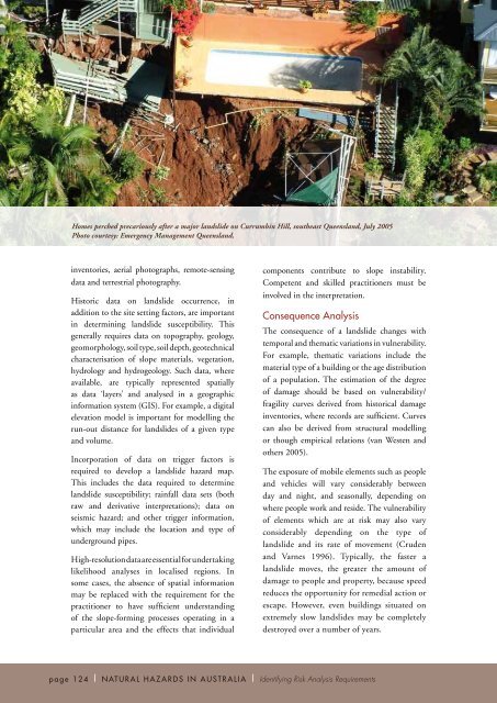
Homes perched precariously after a major landslide on Currumbin Hill, southeast Queensland, July 2005<br />
Photo courtesy: Emergency Management Queensland.<br />
inventories, aerial photographs, remote-sensing<br />
data and terrestrial photography.<br />
Historic data on landslide occurrence, in<br />
addition to the site setting factors, are important<br />
in determining landslide susceptibility. This<br />
generally requires data on topography, geology,<br />
geomorphology, soil type, soil depth, geotechnical<br />
characterisation of slope materials, vegetation,<br />
hydrology and hydrogeology. Such data, where<br />
available, are typically represented spatially<br />
as data ‘layers’ and analysed in a geographic<br />
information system (GIS). For example, a digital<br />
elevation model is important for modelling the<br />
run-out distance for landslides of a given type<br />
and volume.<br />
Incorporation of data on trigger factors is<br />
required to develop a landslide hazard map.<br />
This includes the data required to determine<br />
landslide susceptibility; rainfall data sets (both<br />
raw and derivative interpretations); data on<br />
seismic hazard; and other trigger information,<br />
which may include the location and type of<br />
underground pipes.<br />
High-resolution data are essential for undertaking<br />
likelihood analyses in localised regions. In<br />
some cases, the absence of spatial information<br />
may be replaced with the requirement for the<br />
practitioner to have sufficient understanding<br />
of the slope-forming processes operating in a<br />
particular area and the effects that individual<br />
components contribute to slope instability.<br />
Competent and skilled practitioners must be<br />
involved in the interpretation.<br />
Consequence Analysis<br />
The consequence of a landslide changes with<br />
temporal and thematic variations in vulnerability.<br />
For example, thematic variations include the<br />
material type of a building or the age distribution<br />
of a population. The estimation of the degree<br />
of damage should be based on vulnerability/<br />
fragility curves derived from historical damage<br />
inventories, where records are sufficient. Curves<br />
can also be derived from structural modelling<br />
or though empirical relations (van Westen and<br />
others 2005).<br />
The exposure of mobile elements such as people<br />
and vehicles will vary considerably between<br />
day and night, and seasonally, depending on<br />
where people work and reside. The vulnerability<br />
of elements which are at risk may also vary<br />
considerably depending on the type of<br />
landslide and its rate of movement (Cruden<br />
and Varnes 1996). Typically, the faster a<br />
landslide moves, the greater the amount of<br />
damage to people and property, because speed<br />
reduces the opportunity for remedial action or<br />
escape. However, even buildings situated on<br />
extremely slow landslides may be completely<br />
destroyed over a number of years.<br />
page 124 | NATURAL HAZARDS IN AUSTRALIA | Identifying Risk Analysis Requirements


