3 Mansfield Road - Central Administration - University of Oxford
3 Mansfield Road - Central Administration - University of Oxford
3 Mansfield Road - Central Administration - University of Oxford

Create successful ePaper yourself
Turn your PDF publications into a flip-book with our unique Google optimized e-Paper software.
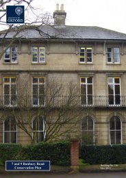
The double-height, apsed drawing room (Figure 9, now seminar room 2) on the first floor is<br />
another significant space. The character <strong>of</strong> the room, running towards the apse at the northern<br />
end, suggests a chapel, perhaps not<br />
surprising from a church builder like<br />
Blomfield Jackson.<br />
The music room, a distinct wing<br />
projecting from the north <strong>of</strong> the main<br />
building, was once probably one <strong>of</strong><br />
the more impressive spaces in the<br />
building. It was subdivided with the<br />
construction <strong>of</strong> the library extension<br />
in 1965-68. It has since been opened<br />
up somewhat but retains little <strong>of</strong> its<br />
original character.<br />
There has been some subdivision in<br />
the <strong>of</strong>fice spaces, but in most cases<br />
the original floor plan can be easily<br />
discerned. In some cases, the original<br />
floor plan has resulted in<br />
interestingly-proportioned <strong>of</strong>fices<br />
with a unique character, e.g. the<br />
lobby-lavatory configuration at the<br />
north-western end <strong>of</strong> the first floor<br />
which creates a cosy triple-suite <strong>of</strong><br />
<strong>of</strong>fices.<br />
Figure 9. The first-floor drawing room looking<br />
northwards<br />
3.3 Archaeological Significance<br />
3 <strong>Mansfield</strong> <strong>Road</strong> is situated within <strong>Oxford</strong> City Council’s Archaeology Area and the<br />
surrounding area has a long history <strong>of</strong> occupation. Considering nearby discoveries, there is a<br />
high potential for significant archaeological material on the site. De Gomme’s 1644 plan<br />
shows that <strong>Oxford</strong>’s Civil War defences do not stretch to this point, though they do cross the<br />
northern part <strong>of</strong> <strong>Mansfield</strong> <strong>Road</strong>. 14 The 17 th -century King’s Mound, Charles I’s earthwork<br />
from where he apparently reviewed his troops, runs through the gardens just north <strong>of</strong> the<br />
building. Several mediaeval houses were demolished for the construction <strong>of</strong> <strong>Mansfield</strong> <strong>Road</strong>,<br />
and elements <strong>of</strong> these may be extant in the surrounding area. Equally, the 1876 OS map<br />
shows that at that time there were several buildings <strong>of</strong> uncertain date in the location <strong>of</strong> 3<br />
<strong>Mansfield</strong> <strong>Road</strong> itself (Figure 2), features <strong>of</strong> which may well survive beneath the present<br />
building.<br />
14 Lattey, R.T., Parsons, E.J.S., and Philip, I.G., ‘A contemporary map <strong>of</strong> the defences <strong>of</strong> <strong>Oxford</strong> in 1644’ in<br />
Oxoniensia I (1936) 161-172.<br />
3 <strong>Mansfield</strong> <strong>Road</strong>, <strong>Oxford</strong> 24<br />
Conservation Plan