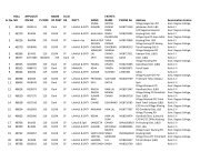
Brief Facts of H.P. - Government of Himachal Pradesh
Brief Facts of H.P. - Government of Himachal Pradesh
Brief Facts of H.P. - Government of Himachal Pradesh

Create successful ePaper yourself
Turn your PDF publications into a flip-book with our unique Google optimized e-Paper software.
Physical Features:<br />
<strong>Himachal</strong> <strong>Pradesh</strong> is almost wholly mountainous<br />
with altitudes ranging from 350 metres to 6,975<br />
metres above the mean sea level. Its location is<br />
between Latitude 30 o 22’40” N to 33 o 12’40” N and<br />
Longitude 75 o 45’55”E to 79 o 04’20” E. It has deeply<br />
dissected topography complex geological structure and<br />
a rich temperate flora in the sub-tropical latitudes.<br />
Physiographically, the State can be divided in to<br />
five zones-viz. (i) Wet Sub-temperate zone,(ii) humid<br />
sub-temperate zone, (iii) dry temperate-alpine high<br />
lands, (iv) humid sub-tropical zone, and(v) sub-humid<br />
sub-tropical zone. Wet sub-temperate zone comprises<br />
Palampur and Dharamshala <strong>of</strong> Kangra district,<br />
Jogindernagar area <strong>of</strong> Mandi district and Dalhousie<br />
area <strong>of</strong> Chamba district, humid sub-temperate zone<br />
comprises the district <strong>of</strong> Kullu, Shimla, parts <strong>of</strong><br />
Mandi, Solan, Chamba, Kangra and Sirmaur, Dry<br />
temperate- Alpine High lands include major parts <strong>of</strong><br />
Lahaul-Spiti, Pangi and Kinnaur, humid sub-tropical<br />
zone consists <strong>of</strong> Bilaspur, Bhattiyat valley <strong>of</strong><br />
District Chamba, Nalagarh area <strong>of</strong> District Solan,<br />
Dehragopipur and Nurpur areas <strong>of</strong> district Kangra and<br />
sub-humid tropical zone comprises <strong>of</strong> District Una,<br />
Paonta-Sahib area <strong>of</strong> District Sirmaour, and Indora<br />
area <strong>of</strong> District Kangra.<br />
(iv)