Resource Access Roads - Ministry of Natural Resources - Ontario.ca
Resource Access Roads - Ministry of Natural Resources - Ontario.ca
Resource Access Roads - Ministry of Natural Resources - Ontario.ca

You also want an ePaper? Increase the reach of your titles
YUMPU automatically turns print PDFs into web optimized ePapers that Google loves.
<strong>Resource</strong> <strong>Access</strong> <strong>Roads</strong> Geospatial Data<br />
Information Management Plan and Data Management Guide<br />
Part E - Guidelines for Editors and Users <strong>of</strong> NRVIS 3.3 <strong>Roads</strong> Layer<br />
This section provides general information and guidelines for editors and users <strong>of</strong> the NRVIS<br />
roads layer.<br />
Editable Data<br />
The amount <strong>of</strong> editing rights will depend on the value in the ROAD_AUTHORITY field. If the<br />
ROAD_AUTHORITY is MNR, then full access to geometry and attributes are provided and the<br />
MNR NRVIS user may post the changes. If the ROAD_AUTHORITY is something other than<br />
MNR (Municipal, MTO, Other), the ORN attributes will not be editable but all other attributes are<br />
editable (MNR attributes). If the geometry is edited on non-MNR segments, the version must<br />
be transferred to the Base Data Infrastructure staff to post into the Database.<br />
The table below provides a series <strong>of</strong> scenarios NRVIS editors or users may encounter and a<br />
solution for these common scenarios.<br />
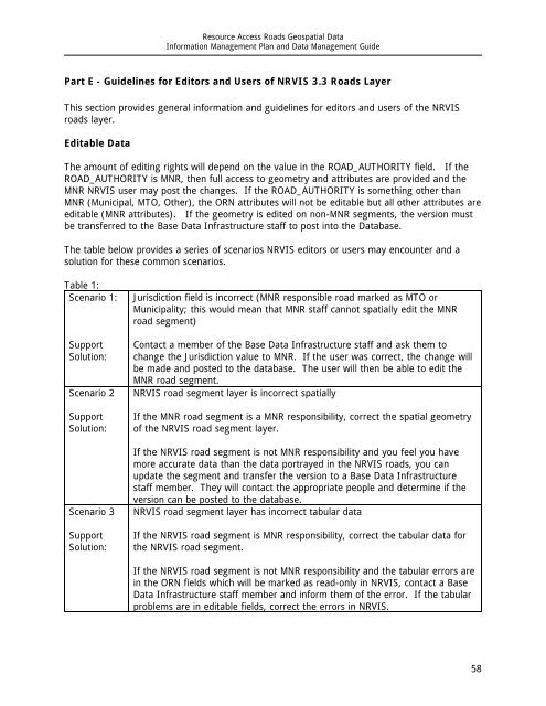
Table 1:<br />
Scenario 1:<br />
Support<br />
Solution:<br />
Scenario 2<br />
Support<br />
Solution:<br />
Scenario 3<br />
Support<br />
Solution:<br />
Jurisdiction field is incorrect (MNR responsible road marked as MTO or<br />
Municipality; this would mean that MNR staff <strong>ca</strong>nnot spatially edit the MNR<br />
road segment)<br />
Contact a member <strong>of</strong> the Base Data Infrastructure staff and ask them to<br />
change the Jurisdiction value to MNR. If the user was correct, the change will<br />
be made and posted to the database. The user will then be able to edit the<br />
MNR road segment.<br />
NRVIS road segment layer is incorrect spatially<br />
If the MNR road segment is a MNR responsibility, correct the spatial geometry<br />
<strong>of</strong> the NRVIS road segment layer.<br />
If the NRVIS road segment is not MNR responsibility and you feel you have<br />
more accurate data than the data portrayed in the NRVIS roads, you <strong>ca</strong>n<br />
update the segment and transfer the version to a Base Data Infrastructure<br />
staff member. They will contact the appropriate people and determine if the<br />
version <strong>ca</strong>n be posted to the database.<br />
NRVIS road segment layer has incorrect tabular data<br />
If the NRVIS road segment is MNR responsibility, correct the tabular data for<br />
the NRVIS road segment.<br />
If the NRVIS road segment is not MNR responsibility and the tabular errors are<br />
in the ORN fields which will be marked as read-only in NRVIS, contact a Base<br />
Data Infrastructure staff member and inform them <strong>of</strong> the error. If the tabular<br />
problems are in editable fields, correct the errors in NRVIS.<br />
58