Wilderness Skills - Olympia Mountaineers
Wilderness Skills - Olympia Mountaineers
Wilderness Skills - Olympia Mountaineers

You also want an ePaper? Increase the reach of your titles
YUMPU automatically turns print PDFs into web optimized ePapers that Google loves.
Optional Features<br />
There are optional features available, in addition to the basic requirements that should be considered. These<br />
extras will increase the cost of the compass, but may be worth the expenditure depending on the intended use.<br />
1. Luminous points - enhances the use of the compass in minimum lighting conditions.<br />
2. Offsetting mechanism - a feature that, when set, will automatically correct for declination in any given<br />
area. The adjustment simultaneously takes care of both map and field bearing.<br />
3. Sighting mirror - more accurate in taking bearings. Cover can be opened to extend straightedge<br />
making map work easier. It may also be used for emergency signaling.<br />
The following brands and models meet all the basic requirements. Some have additional features and are so<br />
noted.<br />
Make - Model Opt. 1 Opt. 2 Opt. 3<br />
Silva - Explorer ̌ ̌<br />
Silva - Polaris<br />
Silva - Ranger ̌ ̌ ̌<br />
Suunto - A10 Partner<br />
Suunto - Leader ̌ ̌<br />
Suunto - Locator ̌ ̌<br />
Suunto - Navigator ̌ ̌ ̌<br />
Map Interpretation<br />
A map is nothing more than a drawing of a piece of the earth's surface, as would be seen<br />
from an airplane, looking straight down. Being able to visualize terrain features from<br />
contour lines is one of the most useful map reading skills that can be developed. The<br />
map not only shows terrain, but also streams, rivers, lakes, roads, trails, and sometimes<br />
man-made objects.<br />
Maps are drawn to SCALE, which is usually printed at the bottom of the map. This<br />
means that a certain distance on a map equals a certain distance in the field. A map is<br />
said to have a LARGE scale when there is a lot of detail within a given area. A BAR<br />
SCALE is usually printed at the bottom in three different units: miles, feet and kilometers. To find the distance<br />
in the field, measure the distance between the two points of the map. Take this measurement and place it just<br />
under one of the bar scales, and then read the field distance.<br />
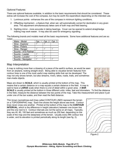
Thin brown (sometimes-red) lines called CONTOUR LINES represent the terrain<br />
on a TOPOGRAPHIC map. Each line shows the height above sea level. Contour<br />
lines never cross one another. Printed at the bottom of the map is the CONTOUR<br />
INTERVAL, which is the difference in height (elevation) between one brown line<br />
and the one next to it. Contour intervals are not the same on all maps. Typically,<br />
they are 40, 80, 100 feet and sometimes as much as 250 feet, depending on the<br />
scale of the map and the steepness of the terrain. Usually every fifth contour line<br />
is wider, and its elevation is printed periodically along its length (see fig. 2).<br />
Figure 2<br />
<strong>Wilderness</strong> <strong>Skills</strong> Module Page 68 of 73<br />
<strong>Olympia</strong> <strong>Mountaineers</strong> - Hiking, Alpine Scrambling and Basic Climbing