Wilderness Skills - Olympia Mountaineers
Wilderness Skills - Olympia Mountaineers
Wilderness Skills - Olympia Mountaineers

Create successful ePaper yourself
Turn your PDF publications into a flip-book with our unique Google optimized e-Paper software.
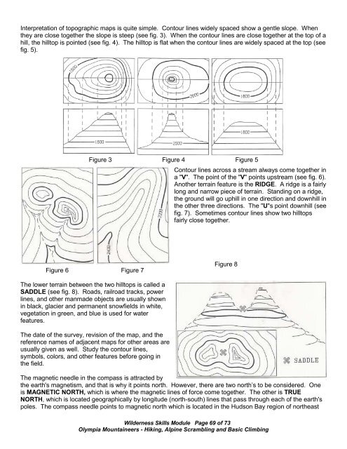
Interpretation of topographic maps is quite simple. Contour lines widely spaced show a gentle slope. When<br />
they are close together the slope is steep (see fig. 3). When the contour lines are close together at the top of a<br />
hill, the hilltop is pointed (see fig. 4). The hilltop is flat when the contour lines are widely spaced at the top (see<br />
fig. 5).<br />
Figure 3 Figure 4 Figure 5<br />
Contour lines across a stream always come together in<br />
a "V". The point of the "V" points upstream (see fig. 6).<br />
Another terrain feature is the RIDGE. A ridge is a fairly<br />
long and narrow piece of terrain. Standing on a ridge,<br />
the ground will go uphill in one direction and downhill in<br />
the other three directions. The "U"s point downhill (see<br />
fig. 7). Sometimes contour lines show two hilltops<br />
fairly close together.<br />
Figure 6 Figure 7<br />
Figure 8<br />
The lower terrain between the two hilltops is called a<br />
SADDLE (see fig. 8). Roads, railroad tracks, power<br />
lines, and other manmade objects are usually shown<br />
in black, glacier and permanent snowfields in white,<br />
vegetation in green, and blue is used for water<br />
features.<br />
The date of the survey, revision of the map, and the<br />
reference names of adjacent maps for other areas are<br />
usually given as well. Study the contour lines,<br />
symbols, colors, and other features before going in<br />
the field.<br />
The magnetic needle in the compass is attracted by<br />
the earth's magnetism, and that is why it points north. However, there are two north’s to be considered. One<br />
is MAGNETIC NORTH, which is where the magnetic lines of force come together. The other is TRUE<br />
NORTH, which is located geographically by longitude (north-south) lines that pass through each of the earth's<br />
poles. The compass needle points to magnetic north which is located in the Hudson Bay region of northeast<br />
<strong>Wilderness</strong> <strong>Skills</strong> Module Page 69 of 73<br />
<strong>Olympia</strong> <strong>Mountaineers</strong> - Hiking, Alpine Scrambling and Basic Climbing