BLUETOOTH TRAFFIC MONITORING --- - I-95 Corridor Coalition
BLUETOOTH TRAFFIC MONITORING --- - I-95 Corridor Coalition
BLUETOOTH TRAFFIC MONITORING --- - I-95 Corridor Coalition

You also want an ePaper? Increase the reach of your titles
YUMPU automatically turns print PDFs into web optimized ePapers that Google loves.
<strong>BLUETOOTH</strong> <strong>TRAFFIC</strong> <strong>MONITORING</strong><br />
---<br />
CONCEPT OF OPERATION &<br />
DEPLOYMENT GUIDELINES<br />
July 17, 2008<br />
Introduction to Bluetooth Traffic Monitoring:<br />
The University of Maryland has developed a probe technique to monitor the travel time on<br />
highways and arterials based on signals available from the point-to-point networking protocol<br />
commonly referred to as Bluetooth. The majority of consumer electronic devices produced<br />
today come equipped with Bluetooth wireless capability to communicate with other devices in<br />
close proximity. For example, many digital cameras use Bluetooth for downloading pictures to a<br />
laptop computer. It is also the primary means to enable hands free use of cell phones. Bluetooth<br />
enabled devices can communicate with other Bluetooth enabled devices anywhere from 1 meter<br />
to about 100 meters, depending on the power rating of the Bluetooth sub-systems in the devices.<br />
The Bluetooth protocol uses an electronic identifier, or tag, in each device called a Machine<br />
Access Control address, or MAC address for short. The MAC address serves as an electronic<br />
nickname so that electronic devices can keep track of who’s who during data communications. It<br />
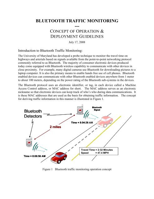
is these MAC addresses that are used as the basis for obtaining traffic information. The concept<br />
for deriving traffic information in this manner is illustrated in Figure 1.<br />
Bluetooth<br />
Detectors<br />
Bluetooth<br />
Signal<br />
2 miles<br />
Time = 8:04:26 AM<br />
Time = 8:06:58 AM<br />
Travel Time = 2:32 Minutes<br />
Speed<br />
= 47.4 MPH<br />
Figure 1 Bluetooth traffic monitoring operation concept
Privacy Concerns<br />
The anonymous nature of this technique is due to the use of MAC addresses as identifiers. MAC<br />
addresses are not directly associated with any specific user account (as is the case with cell<br />
phone geo-location techniques) or any specific vehicle (as is the case with deriving travel time<br />
from automated toll tags). The MAC address of a cell phone, camera, or other electronic<br />
devices, though unique, is not linked to a specific person through any type of central database,<br />
thus minimizing privacy concerns. Additionally, users concerned with privacy can set options in<br />
their device (referred to as ‘Discovery Mode’ or ‘Visibility’) so that the device will not be<br />
detectable.<br />
Concept of Operation<br />
The University of Maryland has developed a portable Bluetooth monitoring system consisting of<br />
several detectors and a central processing unit. These detectors are deployed on a freeway or<br />
arterial in proximity to the roadway at the base of a sign post or guard rail post. These units are<br />
the size of a large briefcase or small carryon. A photo of the device and a sample placement next<br />
to a sign post are shown in Figure 2.<br />
Figure 2<br />
The Bluetooth detector is shown as it would be deployed during data collection.<br />
The unit sits on the ground and is tethered to an existing post.<br />
Detectors need to be tethered to a secure object for security reasons. Local transportation and<br />
security officials should be notified of the use and appearance of the devices, and the devices<br />
should be marked with local contact information. The units contain an internal battery and can<br />
operate for three days without recharging. Data is stored to a removable memory card. In a<br />
typical application detectors are placed from 2 to 4 miles apart along a corridor for 8 to 72 hours.<br />
At the end of the data collection period, the units are collected, data is downloaded from the<br />
memory cards and the battery is recharged.
Sample Data<br />
Studies have indicated that approximately 1 automobile in 20 contains some type of Bluetooth<br />
device that can be detected, this is referred to as the penetration rate. Not every Bluetooth device<br />
is detected at every station so the number of matched detections (a device detected at two<br />
consecutive detectors) is lower than the penetration rate. Even so, a majority of the detected<br />
devices are seen at multiple stations. These matched pairs can be used to develop a sample of<br />
travel time for that particular segment of the roadway. Figure 3 shows data from a segment of<br />
Interstate I-4<strong>95</strong> between Washington, DC and Baltimore, Maryland between 6:30 AM and 12:45<br />
PM. Each data point represents the travel time from a matched detection at each end of the<br />
segment. Figure 3 depicts the impact on travel time as a result of an incident that began around<br />
10 AM, was cleared at approximately 10:50 AM and traffic returned to normal flow around<br />
11:15 AM.<br />
40<br />
Travel Time - Minutes<br />
35<br />
30<br />
25<br />
20<br />
15<br />
One Car’s<br />
Data<br />
10<br />
5<br />
0<br />
6 7 8 9 10 11 12 13<br />
Time of Day<br />
Figure 3<br />
Sample Bluetooth data taken along a segment of I-4<strong>95</strong> between Baltimore and<br />
Washington, DC<br />
Conclusion<br />
The Bluetooth Traffic Monitoring provides an opportunity to collect high quality, high density<br />
travel times by sampling a portion of actual travel times from the traffic stream. By matching<br />
MAC addresses at two different locations, not only is accurate travel time measured, privacy<br />
concerns typically associated with probe systems are minimized. On a cost per data point basis,<br />
Bluetooth traffic monitoring are 1000 times more economical than drive testing. Applications for<br />
the probes include validation of existing systems, corridor travel time studies, arterial signal
synchronization, congestion performance measures, construction zone monitoring, and before<br />
and after studies of capital improvements.