

October 1986 - Oregon Department of Geology and Mineral Industries
October 1986 - Oregon Department of Geology and Mineral Industries
October 1986 - Oregon Department of Geology and Mineral Industries

Create successful ePaper yourself
Turn your PDF publications into a flip-book with our unique Google optimized e-Paper software.
OREGON GEOLOGY<br />
published by the<br />
<strong>Oregon</strong> <strong>Department</strong> <strong>of</strong> <strong>Geology</strong> <strong>and</strong> <strong>Mineral</strong> <strong>Industries</strong><br />
VOLUME 48, NUMBER 10 OCTOBER <strong>1986</strong>
OREGON GEOLOGY<br />
(lSSN 0164·3304)<br />
VOLUME 48, NUMBER 10 OCTOBER <strong>1986</strong><br />
Published monthly by the <strong>Oregon</strong> <strong>Department</strong> <strong>of</strong> <strong>Geology</strong> <strong>and</strong> <strong>Mineral</strong><br />
<strong>Industries</strong> (Volumes 1 through 40 were entitled The Ore Bin).<br />
Governing Board<br />
Sidney R. Johnson, Chairman ...................... Baker<br />
Donald A. Haagensen .......................... Portl<strong>and</strong><br />
Allen P. Stinchfield .......................... North Bend<br />
State GeolOgist ............................ Donald A. Hull<br />
Deputy State Geologist .................... John D. Beaulieu<br />
Publications Manager/Editor ................. Beverly F. Vogt<br />
Associate Editor ..................... Klaus K.E. Neuendorf<br />
Main Office: 910 State Office Building, 1400 SW Fifth Ave., Portl<strong>and</strong><br />
97201, phone (503) 229-5580.<br />
Baker Field Office: 1831 First Street, Baker 97814, phone (503)<br />
523-3133. Howard C. Brooks, Resident Geologist<br />
Grants Pass Field Office: 312 SE "H" Street, Grants Pass 97526,<br />
phone (503) 476-2496.<br />
Len Ramp, Resident Geologist<br />
Mined L<strong>and</strong> Reclamation Program: 1534 Queen Ave. SE, Albany<br />
97321, phone (503) 967-2039. Paul Lawson, Supervisor<br />
Second class postage paid at Portl<strong>and</strong>, <strong>Oregon</strong>. Subscription rates:<br />
1 year $6; 3 years, $15. Single issues, $.75 at counter, $1 mailed.<br />
Available back issues <strong>of</strong> Ore Bin: $.50 at counter, $1 mailed.<br />
Address subscription orders, renewals, <strong>and</strong> changes <strong>of</strong> address to<br />
<strong>Oregon</strong> <strong>Geology</strong>, 910 State Office Building, Portl<strong>and</strong>, OR 97201.<br />
Permission is granted to reprint information contained herein.<br />
Credit given to the <strong>Oregon</strong> <strong>Department</strong> <strong>of</strong> <strong>Geology</strong> <strong>and</strong> <strong>Mineral</strong><br />
<strong>Industries</strong> for compiling this information will be appreciated.<br />
POSTMASTER: Send address changes to <strong>Oregon</strong> <strong>Geology</strong>, 910<br />
State Office Building, Portl<strong>and</strong>, OR 97201.<br />
Information for contributors<br />
<strong>Oregon</strong> <strong>Geology</strong> is designed to reach a wide spectrum <strong>of</strong><br />
readers interested in the geology <strong>and</strong> mineral industry <strong>of</strong> <strong>Oregon</strong>.<br />
Manuscript contributions are invited on both technical <strong>and</strong> general-interest<br />
subjects relating to <strong>Oregon</strong> geology. Two copies <strong>of</strong><br />
the manuscript should be submitted, typed double-spaced throughout<br />
(including references) <strong>and</strong> on one side <strong>of</strong> the paper only.<br />
Graphic illustrations should be camera-ready; photographs should<br />
be black-<strong>and</strong>-white glossies. All figures should be clearly marked,<br />
<strong>and</strong> all figure captions should be typed together on a separate<br />
sheet <strong>of</strong> paper.<br />
The style to be followed is generally that <strong>of</strong> U.S. Geological<br />
Survey publications (see the USGS manual Suggestions to Authors,<br />
6th ed., 1978). The bibliography should be limited to "References<br />
Cited." Authors are responsible for the accuracy <strong>of</strong> the bibliographic<br />
references. Names <strong>of</strong> reviewers should be included in the<br />
"Acknowledgments."<br />
Authors will receive 20 complimentary copies <strong>of</strong> the issue<br />
containing their contribution. Manuscripts, news, notices, <strong>and</strong><br />
meeting announcements should be sent to Beverly F. Vogt, Publications<br />
Manager, at the Portl<strong>and</strong> <strong>of</strong>fice <strong>of</strong> DOG AMI.<br />
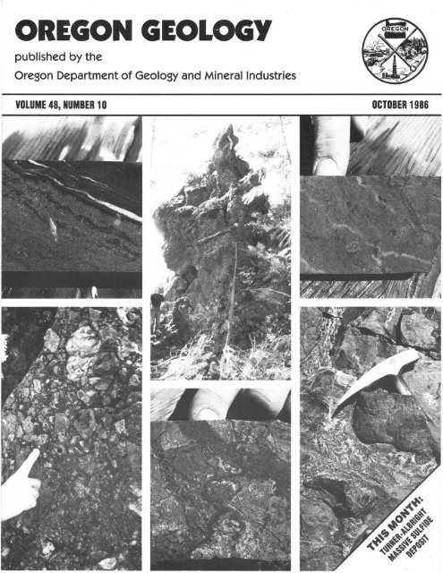
COVER PHOTO<br />
Details from Turner-Albright massive sulfide deposit discussed<br />
in article beginning on next page. Clockwise from upper<br />
left: Cut drill core from stratigraphic top <strong>of</strong> Main Upper Zone (p.<br />
120), showing contact between massive coll<strong>of</strong>orm b<strong>and</strong>ed pyrite/sphalerite<br />
<strong>and</strong> finely laminated black (carbonaceous) mudstone.<br />
- Large "llozzan" outcrop associated with South Zone<br />
gossans (p. 117 <strong>and</strong> 120, footnote). - Cut drill core showing<br />
massive sphalerite replacement <strong>of</strong> basalt within basin-floor rubble<br />
(p. 119). - Hyalcoclastite breccia between basalt pillows (p.<br />
117). - Cut drill core from basin-floor rubble showing hydrothermally<br />
altered basalt <strong>and</strong> silicification <strong>and</strong> pyritization <strong>of</strong><br />
matrix. - Fragmental <strong>and</strong> brecciated textures associated with<br />
"llozzan" (above), including partially silicified <strong>and</strong> pyritized<br />
basalt <strong>and</strong> completely silicified basaltic glass.<br />
OIL AND GAS NEWS<br />
ARCO successful at Mist<br />
ARCO Oil <strong>and</strong> Gas Company drilled the well Columbia<br />
County 14-23 to a total depth <strong>of</strong>2,180 ft <strong>and</strong> has completed it as<br />
a producer from the Clark <strong>and</strong> Wilson s<strong>and</strong>stone at a rate <strong>of</strong> 3.2<br />
MMcfd. ARCO next drilled the Longview Fibre 41-35 to a total<br />
depth <strong>of</strong> 1,585 ft. This well has also been completed as a producer,<br />
but the flow rate has not yet been released. The third well<br />
drilled this summer was the Cavenham Forest <strong>Industries</strong> 33-9.<br />
This well was drilled to a total depth <strong>of</strong> 3,242 ft <strong>and</strong> was plugged<br />
<strong>and</strong> ab<strong>and</strong>oned. ARCO next plans to drill the Cavenham Forest<br />
<strong>Industries</strong> 41-4. This well is permitted as a 2,400-ft test.<br />
Exploratory well planned for Marion County<br />
Damon Petroleum Corp., located in Woodburn, will drill its<br />
Stauffer Farms 35-1 this fall. The well is to be located in sec. 35,<br />
T. 4 S., R. 1 W., near the city <strong>of</strong> Hubbard. The well has a proposed<br />
depth <strong>of</strong> 2,800 ft.<br />
Recent permits<br />
Permit Operator, well, Status, proposed<br />
no. API number Location total depth (ft)<br />
376 ARCO NElli sec. 8 Application;<br />
Col. Co. 42-8-54 T.5 N., R. 4 W. 2,750.<br />
009-00213 Columbia County D<br />
<strong>Mineral</strong> industry costs to be studied<br />
With today's unpredictable mineral markets, it is more critical<br />
than ever before to accurately predict production costs. Both<br />
new <strong>and</strong> existing operations are saddled with small pr<strong>of</strong>it margins<br />
<strong>and</strong> highly variable product prices.<br />
To help mineral producers underst<strong>and</strong> costs, the Northwest<br />
Mining Association will hold its '<strong>Mineral</strong> Industry Cost" short<br />
course on Dec. 1, 2, <strong>and</strong> 3, <strong>1986</strong>, at the Sheraton Hotel in<br />
Spokane, Washington.<br />
Jack Hoskins, head <strong>of</strong> the metallurgy <strong>and</strong> Mining <strong>Department</strong><br />
<strong>of</strong> the College <strong>of</strong> Mines, University <strong>of</strong>Idaho, will serve as<br />
course director. "The problems <strong>of</strong> accurate cost estimating <strong>and</strong><br />
control continue to be foremost in the minds <strong>of</strong> property developers<br />
<strong>and</strong> operators," Hoskins says.<br />
OUo L. Schumacher, president <strong>of</strong> Mining Cost Service in<br />
Spokane, will act as co-director. "Although mineral industry<br />
costs have been the topics <strong>of</strong> short courses in 1976 <strong>and</strong> 1980, the<br />
drastic changes in our industry <strong>and</strong> in metal markets make a new<br />
review essential," Schumacher says.<br />
Hoskins <strong>and</strong> Schumacher have assembled nineteen industry<br />
<strong>and</strong> academic experts to provide practical <strong>and</strong> up-to-the-minute<br />
information on the costs <strong>of</strong> exploration, development, operating,<br />
marketing, <strong>and</strong> environmental control for existing <strong>and</strong> proposed<br />
operations. The short course will be a series <strong>of</strong> working sessions,<br />
not lectures. Financial systems <strong>and</strong> control, labor costs <strong>and</strong> productivity,<br />
environmental permitting, comparison <strong>of</strong> costs <strong>of</strong> mining<br />
methods, processing costs including leaching <strong>of</strong> gold, <strong>and</strong><br />
case studies <strong>of</strong> cost estimating will be studied.<br />
The course, along with the Association's second short course,<br />
"Industrial <strong>Mineral</strong>s - Are They for You?" will immediately<br />
precede the Northwest Mining Association's 92nd Annual Convention,<br />
which will be held in Spokane on Dec. 4, 5, <strong>and</strong>6, <strong>1986</strong>.<br />
College credit will be available. Enrollment will be limited to<br />
200. To register or for more information, contact the Northwest<br />
Mining Association, (509) 624-1158.<br />
- Northwest Mining Association news release<br />
OREGON GEOWGY, VOLUME 48, NUMBER 10, OCTOBER <strong>1986</strong>
Geologic setting <strong>of</strong> the Turner-Albright massive sulfide<br />
deposit, Josephine County, <strong>Oregon</strong><br />
by Michael D. Strickler, Geologist, Litho-Logic Resources, 207-A SW uG" Street, Grants Pass, OR 97526<br />
INTRODUCTION<br />
Several small- to medium-sized volcanogenic massive sulfide<br />
deposits have been identified within ophiolitic volcanic<br />
rocks <strong>of</strong> Josephine County, <strong>Oregon</strong>. The most notable occurrence<br />
located to date is the Turner-Albright deposit (Figure 1,<br />
Plate 1), which was fonned by a combination <strong>of</strong> sub-seafloor<br />
replacement <strong>and</strong> seafloor exhalative (venting) processes within a<br />
back-arc rifting environment. As currently defined, the Turner<br />
Albright contains minimum drill-indicated reserves <strong>of</strong> 6.5 million<br />
tons <strong>of</strong> massive <strong>and</strong> semimassive sulfides. Values are reported<br />
for gold, silver, copper, zinc, <strong>and</strong> cobalt, with 2 to 4 million<br />
tons being potentially economic at current metal prices. Geological<br />
<strong>and</strong> geophysical data suggest that the deposit may be significantly<br />
larger <strong>and</strong> that the present reserves may be substantially<br />
increased by additional exploration adjacent to the known mineralization.<br />
This brief discussion is intended to summarize the<br />
geologic setting <strong>and</strong> history <strong>of</strong> the Turner-Albright <strong>and</strong> to relate<br />
some <strong>of</strong> the factors that may affect a future production decision.<br />
REGIONAL GEOLOGIC SETTING<br />
The regional geology <strong>of</strong> southwestern <strong>Oregon</strong> <strong>and</strong> northwestern<br />
California has been the subject <strong>of</strong> numerous studies,<br />
especially in recent years (Cater <strong>and</strong> Wells, 1953; Wells <strong>and</strong><br />
Walker, 1953; Helming, 1966; Garcia, 1976, 1979; Vail, 1977;<br />
Cunningham, 1979; Ramp <strong>and</strong> Peterson, 1979; Harper, 1980,<br />
1983; <strong>and</strong> others). Pioneer workers, including Diller (1914),<br />
Winchell (1914), <strong>and</strong> Shenon (1933a,b), mapped the many<br />
MAP<br />
LOCATION<br />
mines <strong>and</strong> prospects that were being actively worked in the<br />
region in the early 1900's.<br />
The Turner-Albright deposit occurs in the Western Jurassic<br />
Belt (WJB), the westernmost <strong>and</strong> youngest <strong>of</strong>four arcuate, northsouth-trending<br />
lithotectonic belts that comprise the Klamath<br />
Mountains geomorphic province. The lithologies <strong>and</strong> age relationships<br />
within the Klamaths indicate repeated accretion, beginning<br />
in the early to middle Paleozoic <strong>and</strong> continuing through<br />
the Mesozoic, <strong>of</strong> ophiolitic <strong>and</strong>/or isl<strong>and</strong>-arc terrains <strong>and</strong> associated<br />
sedimentary units to the western edge <strong>of</strong>the North American<br />
continent. Jurassic <strong>and</strong> Cretaceous intrusives (gabbroic to<br />
granitic) intrude all the units. The WJB is in thrust contact with a<br />
similar suite <strong>of</strong> upper Paleozoic <strong>and</strong> Triassic ophiolitic/arc units<br />
to the east <strong>and</strong> is underthrust from the west by the upper Jurassic<br />
to Cretaceous Francisan (Dothan) melange.<br />
Prominent features <strong>of</strong> the WJB in southwestern <strong>Oregon</strong> <strong>and</strong><br />
northwestern California are the Josephine Ophiolite (Figure 2)<br />
<strong>and</strong> coeval volcaniclastics <strong>and</strong> flows associated with isl<strong>and</strong>-arc<br />
development. The Josephine Ophiolite, dated at 157 million<br />
years (m.y.) (Harper <strong>and</strong> Saleeby, 1980), is interpreted to be the<br />
product <strong>of</strong> Jurassic back-arc spreading, with isl<strong>and</strong>-arc development<br />
occurring relatively westward. The ophiolite sequence,<br />
which regionally trends north-northeast with a steep southeast<br />
dip, is essentially complete, with preservation <strong>of</strong> all major lithologies<br />
associated with classic ophiolite stratigraphy. The basal<br />
ultramafic portion (Josephine Peridotite) is comprised predominantly<br />
<strong>of</strong> tectonized harzburgite that has undergone partial to<br />
locally complete serpentinization. Cumulate <strong>and</strong> massive gabbro<br />
is well exposed approximately 2.5 mi southwest <strong>of</strong> the Turner<br />
Albright in the headwaters <strong>of</strong> the Monkey Creek drainage. The<br />
entire sheeted dike complex, from the lower transition with the<br />
gabbro to the upper gradational contact with extrusive volcanic<br />
flows <strong>and</strong> pillows, is preserved essentially intact on both flanks <strong>of</strong><br />
Monkey Creek Ridge.<br />
In southwestern <strong>Oregon</strong>, Jurassic extrusive rocks (both ophiolitic<br />
<strong>and</strong> arc-derived) have been collectively named the Rogue<br />
Volcanics <strong>and</strong> include basic to locally felsic flows, tuffs, breccias,<br />
<strong>and</strong> agglomerates. Volcanic members associated with the Josephine<br />
Ophiolite include basaltic flows <strong>and</strong> pillows with interlayered<br />
breccias, hyaloclastites, <strong>and</strong> relatively thin clastic <strong>and</strong>/or<br />
chemical sedimentary horizons. The Josephine Ophiolite, as well<br />
as the associated isl<strong>and</strong>-arc volcanic rocks, are confonnably<br />
overlain by the Galice Formation, which is composed predomi-<br />
Turner-Albright .--''%r-<br />
Deposit<br />
Scale: I in.=75mi.<br />
Figure 1. Map showing the location <strong>of</strong> the Turner-Albright<br />
massive sulfide deposit. .<br />
OREGON GEOLOGY, VOLUME 48, NUMBER 10, OCTOBER <strong>1986</strong><br />
Figure 2. Schematic diagram showing the gross stratigraphy <strong>of</strong><br />
the Josephine Ophiolite <strong>and</strong> the relative positions <strong>of</strong> the various<br />
units that occur in ophiolite suites. The Tumer-Albright deposit is<br />
located immediately above the base <strong>of</strong> the extrusive flows <strong>and</strong><br />
pillows.<br />
115
nantly <strong>of</strong> interbedded graywacke <strong>and</strong> shale. Type localities for<br />
the Rogue <strong>and</strong> Galice Formations occur northwest <strong>of</strong> Grants<br />
Pass in the Galice District <strong>and</strong> as such are associated with<br />
isl<strong>and</strong>-arc development. Harper (1983) has proposed that the<br />
WJB be divided into two terrains: a northern Rogue River terrain,<br />
which would include the intermediate to locally felsic isl<strong>and</strong>-arc<br />
volcaniclastic rocks <strong>and</strong> flows typical <strong>of</strong> the Galice District, <strong>and</strong> a<br />
southern Josephine terrain, represented by the mafic <strong>and</strong> ultramafic<br />
units <strong>of</strong> the Josephine Ophiolite.<br />
Precious- <strong>and</strong> base-metal mineralization within the WJB is<br />
widespread <strong>and</strong> consists <strong>of</strong> several varied genetic types. In addition<br />
to the Turner-Albright, several other massive sulfide deposits<br />
have been located. While a lack <strong>of</strong> data prohibits a definitive<br />
genetic classification for most <strong>of</strong> the showings, it is probable that<br />
several may be associated with ophiolite development (e.g.,<br />
Monumental, Fall Creek, Eagle Group), while others appear to<br />
be related to isl<strong>and</strong>-arc development (e.g., Almeda, G<strong>of</strong>f, Silver<br />
Peak, Yankee Silver Lode). Numerous very high-grade gold/silver<br />
/ copper/zinc occurrences commonly associated with mafic to<br />
granitic intrusives occur throughout the Klamath Mountains.<br />
Both vein <strong>and</strong> high-grade gold "pockets" have eroded to form<br />
locally rich placer deposits, many <strong>of</strong> which have been extensively<br />
worked by methods ranging from pick -<strong>and</strong>-shovel to large-scale<br />
hydraulic mining.<br />
TURNER-ALBRIGHT DEPOSIT<br />
Geographic setting<br />
The Turner-Albright deposit is situated in southern Josephine<br />
County, immediately north <strong>of</strong> the California border <strong>and</strong> approximately<br />
2 mi west <strong>of</strong> Highway 199 (Figure 1). Access to the<br />
Turner-Albright is via Lone Mountain Road in O'Brien, <strong>Oregon</strong>,<br />
which parallels the West Fork <strong>of</strong> the lllinois River to the turn<strong>of</strong>f<br />
to the property, a distance <strong>of</strong> approximately 6 mi. From the<br />
turn<strong>of</strong>f, an extensive system <strong>of</strong> access <strong>and</strong> drill roads provide<br />
year-round entry to most portions <strong>of</strong> the deposit.<br />
Relief at the Turner-Albright is moderate to locally steep,<br />
with elevations ranging from 2,000 to 3,100 ft. Area rainfall<br />
during the winter months is quite heavy, with seasonal averages<br />
in excess <strong>of</strong> 100 in. to be expected. Snowfall is common above<br />
3,000 ft <strong>and</strong> can last from December through April. Storms come<br />
in groups, with weeks <strong>of</strong> clear weather common between systems.<br />
Summers are hot <strong>and</strong> dry, with highs above 100° F not<br />
uncommon from July through mid-September. Steep slopes<br />
covered with thick st<strong>and</strong>s <strong>of</strong> brush <strong>and</strong> timber, old-growth poison<br />
oak, <strong>and</strong> yellow jackets with a special vengeance for geologists<br />
all tend to hinder field activities during the summer months.<br />
Property history<br />
<strong>Mineral</strong>ization associated with the Turner-Albright deposit<br />
~<br />
~<br />
STOCKWORK SULFIDES<br />
MINERALIZED BASALT<br />
D BASALT<br />
[;il ...<br />
. .. GABBRO<br />
~ DIKE/EXTRUSIVE<br />
TRANSITION ZONE<br />
8 SERPENTINITE<br />
0' 500'<br />
1000'<br />
!<br />
-- ! --'<br />
1":50d<br />
CONTOUR INTERVAL: 100'<br />
Figure 3. Generalized surface geology <strong>of</strong> the Turner-Albright deposit <strong>and</strong> vicinity. F-J through F-5 indicate F-series faults; R-J <strong>and</strong> R-2<br />
indicate R-series faults.<br />
116 OREGON GEOLOGY, VOLUME 48, NUMBER 10, OCTOBER <strong>1986</strong>
was originally located in the late 1800's. Early efforts concentrated<br />
on developing the potential gold content <strong>of</strong> several discontinuous<br />
gossan outcrops located on or near the ridge separating<br />
Blue Creek from the headwaters <strong>of</strong> the West Fork <strong>of</strong> the Illinois<br />
River. Sporadic exploration <strong>and</strong> limited development continued<br />
through the 1930's, but these efforts were not successful in<br />
defining an economic reserve. Several short crosscuts driven at<br />
the base <strong>of</strong> the oxide horizon reached primary sulfides that were<br />
<strong>of</strong> sufficient grade to allow three claims to be patented in the late<br />
1950's.<br />
Exploration <strong>of</strong> the underlying sulfide deposit began in earnest<br />
in 1954 with a one-year program by Granby International. Associated<br />
Geologists <strong>of</strong> Grants Pass continued exploration below the<br />
gossans intermittently throughout the 1960's <strong>and</strong> early 1970's<br />
with several programs consisting <strong>of</strong> churn <strong>and</strong> shallow diamond<br />
core drilling. A two-year program by American Selco in 1974-<br />
1975 explored the potential <strong>of</strong> the southernmost (South Zone)<br />
gossans <strong>and</strong> resulted in drill-indicated reserves <strong>of</strong> 150,000 tons<br />
<strong>of</strong> sulfide ore averaging 1.70 percent copper <strong>and</strong> 0.03 oz/ton <strong>of</strong><br />
gold across an 8-ft-wide zone <strong>of</strong> highly siliceous basaltic breccias.<br />
Evidence <strong>of</strong> a large mineralized body north <strong>of</strong> the South<br />
Zone was indicated by an induced polarization geophysical survey<br />
<strong>and</strong> three short diamond drill holes; however, American<br />
Selco considered the prospects <strong>of</strong> locating an economic deposit<br />
poor <strong>and</strong> allowed its option to expire at the end <strong>of</strong> 1975.<br />
Baretta Mines, Ltd., <strong>of</strong> Calgary, Alberta, Canada, obtained an<br />
option upon termination <strong>of</strong> the American Selco program. Through<br />
August 1981, Baretta Mining, Inc., a wholly-owned subsidiary,<br />
conducted extensive exploration on the Turner-Albright itself, as<br />
well as initial exploration <strong>of</strong> favorable units to the south <strong>and</strong><br />
southwest. A total <strong>of</strong> 30 diamond core holes, with an aggregate<br />
length <strong>of</strong> 35,500 ft, were completed at the Turner-Albright,<br />
resulting in an indicated in-place geologic reserve <strong>of</strong> 3 million<br />
tons averaging 0.09 oz/ton <strong>of</strong> gold, with additional values in<br />
copper, zinc, silver, <strong>and</strong> cobalt. Drilling by Nor<strong>and</strong>a Exploration<br />
in 1982 <strong>and</strong> Rayrock Mines, Inc., in 1983-1984 continued to<br />
refine both the geologic <strong>and</strong> structural characteristics <strong>of</strong> the<br />
deposit. Drilling on the deposit to date exceeds 75,000 ft in 80<br />
separate drill holes. At the present time, reserve estimates place<br />
the Turner-Albright at 2 to 4 million tons averaging approximately<br />
0.12 oz/ton <strong>of</strong> gold, 0.60 oz/ton <strong>of</strong> silver, 1.55 percent<br />
copper, 3.70 percent zinc, <strong>and</strong> 0.50 percent cobalt. The wide<br />
range in tonnage reflects the current uncertainty over the full<br />
effect that post-mineralization faulting may have had on the<br />
continuity <strong>of</strong> portions <strong>of</strong> the deposit.<br />
Recently, two separate studies <strong>of</strong> the Turner-Albright have<br />
been initiated by branches <strong>of</strong> the Federal Government to study<br />
the genetic <strong>and</strong> metallurgical characteristics <strong>of</strong> the deposit. A<br />
team <strong>of</strong> geologists, marine geologists, <strong>and</strong> geochemists from the<br />
U.S. Geological Survey (USGS) are studying the Turner-Albright<br />
to determine its similarities to active hydrothermal systems that<br />
have recently been identified at several venting sites along midocean<br />
ridges. In addition, the U.S. Bureau <strong>of</strong> Mines is beginning a<br />
detailed mineralogical study <strong>of</strong> the cobalt-bearing sulfides atthe<br />
Turner-Albright. Their intent is to help in defining <strong>and</strong> developing<br />
a metall urgical process to treat the complex ores found at the<br />
deposit.<br />
Lithology<br />
The Turner-Albright deposit is situated near the base <strong>of</strong> the<br />
extrusive pillow lavas <strong>and</strong> flows <strong>of</strong> the Josephine Ophiolite,<br />
50-200 m above their gradational lower contact with the sheeted<br />
dike sequence. In the immediate vicinity <strong>of</strong> the Turner-Albright,<br />
the majority <strong>of</strong> ophiolite-related lithologies normally found stratigraphically<br />
below the extrusives are missing due to postophiolitic<br />
low-angle faulting that has juxtaposed the uppermost<br />
portion <strong>of</strong> the sheeted dike/extrusive rock transition zone <strong>and</strong><br />
serpentinized mantle peridotite. In comparison with the total<br />
OREGON GEOLOGY, VOLUME 48, NUMBER 10, OCTOBER <strong>1986</strong><br />
section as exposed south <strong>of</strong> the Turner-Albright, up to 1.5 km or<br />
more <strong>of</strong>the ophiolite stratigraphy is missing, including the middle<br />
<strong>and</strong> lower sheeted dikes, the entire massive <strong>and</strong> cumulate<br />
gabbro sequence, <strong>and</strong> an unknown amount <strong>of</strong> mantle peridotite.<br />
With the exception <strong>of</strong> numerous mafic pegmatite <strong>and</strong> rodingite<br />
dikes that occur within major shears in the ultramafic mass, all<br />
<strong>of</strong> the lithologies currently exposed at the Turner-Albright are<br />
interpreted to be associated with the primary development <strong>of</strong> the<br />
Josephine Ophiolite (Figure 3). Following is a brief description <strong>of</strong><br />
the major units identified at the Turner-Albright deposit.<br />
Basalt: Extrusive volcanic rocks occurring at the Turner<br />
Albright consist <strong>of</strong> basaltic flows, pillows, <strong>and</strong> hyaloclastites that<br />
commonly contain plagioclase, clinopyroxene, <strong>and</strong>/or iron titanium<br />
phenocrysts. Feldspar micro lites <strong>and</strong>/ or calcite veinlets <strong>and</strong><br />
amygdules occur locally, <strong>and</strong> individual units may be locally<br />
vesicular. Well-developed pillow structures are evident, both in<br />
outcrop <strong>and</strong> in drill core. Minor to locally intense alteration<br />
occurs, consisting <strong>of</strong> prehnite/pumpellyite, chlorite, sphene, <strong>and</strong><br />
albite (±silica, hematite, <strong>and</strong> epidote), with increased alteration<br />
being localized within <strong>and</strong> adjacent to zones <strong>of</strong> shearing <strong>and</strong><br />
faulting. Except where associated with mineralization, clinopyroxene<br />
is rarely altered to any degree. Regional prehnite/pumpellyite-facies<br />
metamorphism has overprinted much <strong>of</strong> the original<br />
alteration associated with seafloor <strong>and</strong> hydrothermal reactions,<br />
<strong>and</strong> it is <strong>of</strong>ten difficult to determine the age or origin <strong>of</strong> specific<br />
alteration products.<br />
Recent work by Robert Zierenberg <strong>of</strong> the USGS has defined a<br />
second extrusive unit that is <strong>of</strong> limited extent <strong>and</strong> apparently<br />
restricted to the mineralized horizons. To date, this unit, which<br />
consists <strong>of</strong> glassy fragments <strong>of</strong> a relatively primitive mafic<br />
magma, has not been found as flows or pillows. The rock typically<br />
exhibits phenocrysts <strong>of</strong> olivine <strong>and</strong>/or chromium spinel<br />
(with occasional plagioclase) in a groundmass <strong>of</strong> glass <strong>and</strong><br />
radiating clusters <strong>of</strong> quenched pyroxene crystals. Extensive hydrothermal<br />
alteration within the mineralized horizon commonly<br />
masks the nature <strong>of</strong> many <strong>of</strong> the fragments; however, where<br />
primary textures are still visible, clasts <strong>of</strong> the regionally dominant<br />
plagioclase-bearing lava series appear to be restricted to the<br />
lowest portions <strong>of</strong> the mineralized horizons <strong>and</strong> may represent<br />
minor accumulations <strong>of</strong> rubble on the seafloor prior to the extrusion<br />
<strong>of</strong> the mafic lavas.<br />
Gabbro (coarse-grained basalt): As applied at the Turner<br />
Albright, the term "gabbro" refers to diabasic to microgabbroic<br />
(locally gabbroic) textures that occur within the cores <strong>of</strong> thick<br />
extrusive basalt flows <strong>and</strong>/or pillows. These units commonly<br />
contain plagioclase <strong>and</strong>/or pyroxene phenocrysts up to 5 mm<br />
long in a generally fine-grained to aphanitic groundmass. To<br />
date, there is no compelling evidence to indicate an intrusive<br />
origin for the unit, <strong>and</strong> the gabbro is interpreted to represent<br />
coarse-grained members <strong>of</strong> the dominant plagioclase-bearing<br />
lava series. Thick sections (>50 m) <strong>of</strong> gabbroic-textured flows<br />
commonly occur within 10m <strong>of</strong> the top <strong>of</strong> the mineralized<br />
horizons <strong>and</strong> may represent ponding <strong>of</strong> basaltic lavas within the<br />
primary depositional basin.<br />
Mudstone: Very fine-grained clastic sedimentary units oceLLI<br />
as definable horizons 10 cm to 5 m thick, as minor interpillow<br />
<strong>and</strong> interflow accumulations, <strong>and</strong> within the matrix <strong>of</strong>hyaloclastite<br />
breccias. Color varies from red (hematitic) to green, brown,<br />
gray, <strong>and</strong> black (carbonaceous). Green <strong>and</strong> gray mudstones are<br />
<strong>of</strong>ten indistinguishable from silicified basaltic gouge in drill core.<br />
Measurements <strong>of</strong> bedding from outcrop, as well as subsurface<br />
structural calculations from three points, indicate a regular<br />
north-northeast strike to the units (subparallel to the regional<br />
trend <strong>of</strong>the ophiolite); however, dips vary from 30° SE. to nearly<br />
vertical. Composition <strong>of</strong> individual clasts is difficult to deter-<br />
117
....<br />
QC<br />
EXPLANATION<br />
BASALT: Mafic oceanic flOWI <strong>and</strong> pille"... MInor to locally lnt.n.. olt.ration<br />
(chlOrltlc ond o'Qilhc; +1- silica, "'mollt., <strong>and</strong> epidote).<br />
SEIiPEMTIMITt<br />
GABBRO: DiaboliC to rnlc,o_\Iabbroic (locally
mine, but both hemipelagic <strong>and</strong> local sources probably contributed<br />
to the formation <strong>of</strong> the muds. Local increases in the silica<br />
content <strong>of</strong> the sediments indicate an exhalative or biogenic<br />
source for at least a portion <strong>of</strong> the material. Radiolarians have<br />
been observed in several <strong>of</strong> the more siliceous mudstones, <strong>and</strong><br />
confirm an approximate I55-m.y. date for the ophiolite (Harper,<br />
personal communication, 1984). Thin (up to I-m-thick) mudstone<br />
layers commonly cap the exhalative horizons <strong>and</strong> appear to<br />
be laterally more extensive than the sulfide bodies themselves, as<br />
several mud horizons extend beyond the known limits <strong>of</strong> sulfide<br />
mineralization. At least two, <strong>and</strong> possibly three, additional clastic<br />
horizons have been identified at the Turner-Albright but are not<br />
known to be associated with sulfide development.<br />
Basin-floor rubble: From an examination <strong>of</strong> textures associated<br />
with the sulfide bodies located at the Turner-Albright, it is<br />
apparent that a large portion <strong>of</strong> the deposit occurs as a replacement<br />
<strong>of</strong> brecciated basalt fragments. The basin-floor rubble<br />
(Figure 4) represents accumulations <strong>of</strong> up to 75 m <strong>of</strong> brecciated<br />
basalt that covered the original depositional basin prior to the<br />
onset <strong>of</strong> hydrothermal activity <strong>and</strong> the venting <strong>of</strong> the sulfide<br />
horizons. The majority <strong>of</strong>the silica stockwork sulfides, as well as<br />
a large portion <strong>of</strong> the massive sulfide horizon, may occur within<br />
highly altered portions <strong>of</strong> this unit. Intense hydrothermal alteration<br />
within this section <strong>of</strong> the Turner-Albright stratigraphy obscures<br />
the composition <strong>of</strong> many <strong>of</strong> the fragments; however, it is<br />
apparent that fragments <strong>of</strong> the mafic lava series form the majority<br />
<strong>of</strong> the unit, with clasts <strong>of</strong> the regionally dominant plagioclasebearing<br />
lava generally restricted to the base <strong>of</strong> the rubble pile.<br />
Talus deposits: High-angle faulting associated with the formation<br />
<strong>of</strong> the Turner-Albright deposit resulted in several moderate-<br />
to high-relieffault scarps in the original depositional basin.<br />
Brecciation <strong>and</strong> erosion led to the accumulation <strong>of</strong> talus deposits<br />
at the base <strong>of</strong> these structures. Individual talus piles can include<br />
fragments <strong>of</strong> basalt, mudstone, <strong>and</strong> sulfides, with minor amounts<br />
<strong>of</strong> gabbro. The talus deposits commonly have been subjected to a<br />
high degree <strong>of</strong> internal shearing. Sulfides occur as angular to<br />
sub rounded fragments derived from preexisting, faulted exhalative<br />
<strong>and</strong> stockwork horizons, as well as replacement deposits<br />
formed by later fluid movement through units. As defined at the<br />
Turner-Albright, the talus deposits are differentiated from the<br />
basin-floor rubble by their stratigraphic position at the top <strong>of</strong> the<br />
sulfide horizons, their lack <strong>of</strong> extensive hydrothermal alteration,<br />
<strong>and</strong> the presence <strong>of</strong> mineralized fragments derived from the<br />
existing sulfide bodies. It is likely, however, that portions <strong>of</strong> the<br />
basin-floor rubble may actually represent pre-mineralization<br />
talus deposits <strong>and</strong> may account for mineralized areas containing<br />
plagioclase-bearing lava fragments within the predominantly<br />
mafic basin-floor rubble.<br />
Sheeted dikes: Ophiolitic sheeted dikes are characterized by<br />
subparallel diabasic dikes <strong>and</strong> are interpreted to represent the<br />
conduits for the magma that supplied the overlying extrusive<br />
flows <strong>and</strong> pillows. The upper <strong>and</strong> lower contacts <strong>of</strong> the unit as a<br />
whole are commonly gradational. The upper transition zone with<br />
the extrusive lavas is composed <strong>of</strong> diabasic dikes with a downward<br />
decreasing proportion <strong>of</strong> basaltic screens, while the lower<br />
contact zone with the massive gabbro is characterized by extremely<br />
erratic <strong>and</strong> confusing diabase/gabbro textural variations.<br />
Due to faulting that has completely removed the lower portions<br />
<strong>of</strong> the ophiolite, only the uppermost portion <strong>of</strong> the upper<br />
transition zone remains at the Turner-Albright. This portion <strong>of</strong><br />
the Turner-Albright stratigraphy is poorly exposed <strong>and</strong> has been<br />
identified only in several drill holes in the northwest portion <strong>of</strong><br />
the deposit <strong>and</strong> in extensively weathered outcrops in fault contact<br />
with serpentinite. Individual dike margins are marked by chill<br />
zones up to 1 cm across <strong>and</strong> are <strong>of</strong>ten brecciated. Moderate to<br />
OREGON GEOLOGY, VOLUME 48, NUMBER 10, OCTOBER <strong>1986</strong><br />
locally intense epidote alteration is common. Textures within the<br />
cores <strong>of</strong> individual dikes <strong>and</strong> the enclosing basaltic screens are<br />
<strong>of</strong>ten indistinguishable, which makes identification <strong>of</strong> this transition<br />
zone extremely difficult in outcrop where the chill <strong>and</strong>/or<br />
breccia margins are generally obscured.<br />
Peridotite/serpentinite: Partially to completely serpentinized<br />
mantle peridotite occurs immediately west <strong>of</strong> the Turner-Albright<br />
in the headwaters <strong>of</strong> the North Fork <strong>of</strong> the Illinois River. Pods <strong>of</strong><br />
serpentinized dunite also occur <strong>and</strong> may represent primary cumulate<br />
differentiation within the upper mantle. Mafic pegmatite<br />
<strong>and</strong> rodingite dikes are common along the faulted contact with<br />
the extrusive basalt/sheeted dike transition zone, as well as in<br />
shear zones within the peridotites. Thin (1- to 3-cm-thick) seams<br />
<strong>of</strong> powdered magnetite also occur locally along the contact. The<br />
serpentinites are highly magnetic relative to the other units in the<br />
vicinity <strong>and</strong> can be readily located by their magnetic signature.<br />
<strong>Mineral</strong>ization<br />
Sulfide minerals identified at the Turner-Albright include<br />
pyrite (± marcasite), sphalerite, chalcopyrite, <strong>and</strong> linnaeite, with<br />
trace amounts <strong>of</strong> tetrahedrite, stannite, galena, <strong>and</strong> pyrrhotite.<br />
While assumed contributions from multiple vent sources <strong>and</strong><br />
extensive post-mineralization faulting complicate any study <strong>of</strong><br />
the primary zonation patterns, it appears that the original metal<br />
distribution resulted in copper/gold-rich centers at depth within<br />
the basin-floor rubble <strong>and</strong> proximal to the vents, with zinc/silver<br />
<strong>and</strong> pyrite with cobalt zones occurring with increasing distance<br />
from the venting sites. Limited thin- <strong>and</strong> polished-section work<br />
indicates that the metallurgical characteristics <strong>of</strong> the deposit are<br />
complex <strong>and</strong> may complicate extraction <strong>of</strong> the base <strong>and</strong> precious<br />
metals. Fine-grained chalcopyrite <strong>and</strong> sphalerite are tightly intergrown<br />
with pyrite <strong>and</strong>, to a limited extent, with each other. Gold<br />
occurs as discrete micron-sized blebs within chalcopyrite (<strong>and</strong>, to<br />
a limited extent, sphalerite) <strong>and</strong> pyrite. This gold/pyrite association<br />
results in low to locally moderate gold values (0.02 to 0.07<br />
oz/ton) in the distal pyrite halo in the absence <strong>of</strong> any base metal<br />
credits. Cobaltiferous linnaeite occurs as rims on pyrite grains.<br />
Porous coll<strong>of</strong>orm marcasite is most abundant in the uppermost<br />
portion <strong>of</strong> the deposit <strong>and</strong> may in part be a product <strong>of</strong> nearsurface<br />
alteration <strong>of</strong> the primary ion sulfides. It must be stressed<br />
that these findings are fragmentary <strong>and</strong> that a final metallurgical<br />
definition <strong>of</strong> the deposit remains to be made.<br />
As currently defined, the sulfide bodies at the Turner-Albright<br />
are composed <strong>of</strong> three interrelated types <strong>of</strong> mineralization (Figure<br />
4). Massive sulfide horizons up to 30 m thick <strong>and</strong> containing<br />
>50 percent total sulfide content occur at the stratigraphic top <strong>of</strong><br />
Figure 4. Stratigraphic cross section during the late stages <strong>of</strong> the<br />
development <strong>of</strong> the Tumer-Albright deposit <strong>and</strong> prior to the deposition<br />
<strong>of</strong> the clastic (±silica) mudstone horizon.<br />
119
the mineralized section. A silica stockwork stringer zone consisting<br />
<strong>of</strong> highly altered breccias occurs below <strong>and</strong> lateral to the<br />
massive sulfides. Total sulfide content generally decreases to<br />
trace amounts in the stringer zone with distance from the main<br />
exhalative centers, resulting in a third definable horizon, termed<br />
a mineralized basalt, which contains less than 20 percent total<br />
sulfides. The potentially economic portions <strong>of</strong> the deposit are<br />
generally restricted to the massive <strong>and</strong> stringer horizons but are<br />
not necessarily associated with the greatest sulfide content. A<br />
large percentage <strong>of</strong> the massive horizon at the northern end <strong>of</strong> the<br />
deposit is composed essentially <strong>of</strong> massive pyrite/marcasite <strong>and</strong><br />
is <strong>of</strong> a relatively low economic grade. Where exposed at the<br />
surface, all three units oxidize to form gossans or "llozzans"* that<br />
mark the updip, western limit <strong>of</strong> the deposit. Limited outcrop<br />
sampling <strong>and</strong> shallow drilling support the interpretation that the<br />
majority <strong>of</strong> the gossans (<strong>and</strong> "llozzans") were derived from<br />
portions <strong>of</strong> the deposit with a relatively low gold content <strong>and</strong><br />
therefore have little potential to develop substantial reserves <strong>of</strong><br />
leachable ore.<br />
The massive sulfide horizons that occur at the Turner-Albright<br />
are interpreted to have been formed either as seafloor<br />
exhalites or by the extensive alteration <strong>and</strong> replacement <strong>of</strong> basaltic<br />
breccias resulting in nearly complete obliteration <strong>of</strong> all primary<br />
textural features. Evidence <strong>of</strong> brecciation within the massive<br />
horizon commonly increases at lower stratigraphic levels,<br />
with ghosts <strong>of</strong> almost completely replaced basaltic clasts grading<br />
into highly mineralized rock with identifiable basalt <strong>and</strong> chert(?)<br />
fragments. It is probable that many or all <strong>of</strong> the chert fragments,<br />
which are commonly non mineralized, are actually completely<br />
silicified basaltic glass. The origin <strong>of</strong> any given portion <strong>of</strong> the<br />
massive horizon (i.e., exhalite or total replacement) may be<br />
difficult to determine due to this extensive alteration, <strong>and</strong> it is<br />
<strong>of</strong>ten impossible to define the original rock/water interface.<br />
From the amount <strong>of</strong> basaltic fragments within the sulfide horizons,<br />
it is clear that the majority <strong>of</strong> the mineralization at the<br />
Turner-Albright was the result <strong>of</strong> partial to complete replacement<br />
<strong>of</strong> basaltic breccias. The uppermost portion <strong>of</strong> the massive<br />
horizon, however, commonly exhibits fragmental textures, <strong>and</strong> it<br />
is possible that some <strong>of</strong> this sulfide brecciation may represent<br />
collapsed chimney structures that were initially built by the<br />
venting <strong>of</strong> sulfide-rich fluids on the sea floor. In addition, several<br />
small worm casts (1-2 mm in diameter) have been tentatively<br />
identified. These two bits <strong>of</strong> evidence support an exhalative<br />
seafloor origin for the upper 1-3 m <strong>of</strong> the deposit.<br />
At the Turner-Albright, the silica stockwork stringer zone<br />
contains from 20 to 50 percent primary sulfides <strong>and</strong> represents a<br />
conformable transition from essentially complete replacement <strong>of</strong><br />
basaltic breccias to non mineralized flows, pillows, <strong>and</strong> hyaloclastites.<br />
The contact between the silica stockwork zone <strong>and</strong> the<br />
overlying massive sulfides (as well as with the more distal mineralized<br />
basalt) is gradational, <strong>and</strong> the actual location is somewhat<br />
irregular <strong>and</strong> arbitrary. The silica stockwork is almost certainly a<br />
result <strong>of</strong> the percolation <strong>of</strong> mineralizing fluids through basaltic<br />
rubble <strong>and</strong> is characterized by silica flooding <strong>of</strong> the breccias, with<br />
the addition <strong>of</strong> pyrite (± marcasite), chalcopyrite, sphalerite, <strong>and</strong><br />
accessory sulfide minerals. <strong>Mineral</strong>ized flows <strong>and</strong>/or pillows<br />
have not been identified within the silica stockwork. Hydrothermal<br />
penetration <strong>of</strong> the breccia pile resulted in substantial alteration<br />
<strong>of</strong> the original rock (silica+sulfides+chlorite+albite). From a<br />
study <strong>of</strong> partially altered fragments within the silica stockwork, it<br />
is apparent that the majority <strong>of</strong> the clasts are related to the mafic<br />
lavas discussed above. The degree <strong>of</strong> mineralization <strong>and</strong> the<br />
*"L1ozzan" is a term coined by the writer to describe "gossanlike"<br />
material derived from the oxidation <strong>of</strong> sulfide-bearing rocks containing<br />
less than 50 percent total primary sulfide minerals. The term is in honor <strong>of</strong><br />
Lloyd Frizzell, whose faith in the "llozzans" at the Turner-Albright kept<br />
the project alive through the early days <strong>of</strong> exploration in the 1960's <strong>and</strong><br />
1970's.<br />
120<br />
economic value <strong>of</strong> the silica stockwork stringer zone are both<br />
somewhat erratic. This may in part be due to the original configuration<br />
<strong>of</strong> the rubble pile, with areas <strong>of</strong> higher mineralization<br />
reflecting increased fluid movement along paths <strong>of</strong> greatest<br />
permeability.<br />
<strong>Mineral</strong>ized basalt incl udes the portions <strong>of</strong> the volcanic breccias<br />
<strong>and</strong> flows that were subjected to alteration by hydrothermal<br />
fluids 'but that contain a total sulfide content <strong>of</strong> less than 20<br />
percent. Preliminary relogging <strong>of</strong> selected drill core indicates<br />
that, while some <strong>of</strong> the breccia fragments are related to the mafic<br />
lavas, clasts <strong>of</strong>the plagioclase-bearing lava series occur. It is also<br />
evident that mineralization within flow units, as opposed to being<br />
restricted to altered breccias, occurs to a limited extent at the<br />
northern end <strong>of</strong> the deposit. An increase in hematitic alteration<br />
has also been noted within breccias <strong>and</strong> flows that occur stratigraphically<br />
below <strong>and</strong> lateral to the sulfide-rich portions <strong>of</strong> this<br />
unit. The mineralized basalts, which are generally <strong>of</strong> very low<br />
economic grade, are interpreted to represent the most distal<br />
effects <strong>of</strong> the mineralizing fluids.<br />
Structure<br />
The majority <strong>of</strong> the known sulfides at the Turner-Albright<br />
occur as three vertically stacked horizons that trend northeast<br />
with a moderate southeast dip. These three zones occur in two,<br />
<strong>and</strong> possibly three, separate time-stratigraphic horizons, <strong>and</strong><br />
have been designated the Upper High-grade Zone (UHZ), the<br />
Main Upper Zone (MUZ), <strong>and</strong> the Main Lower Zone (MLZ).<br />
Post-mineralization faulting has broken the MUZ <strong>and</strong> MLZinto<br />
somewhat discrete fault-bounded mineralized blocks; however,<br />
in many cases the original thickness <strong>of</strong> the disrupted sulfide<br />
horizon was greater than the displacement along the fault, so that<br />
when the fault is intercepted in drill core, no readily discernible<br />
lithology change occurs across the structure. This is especially<br />
true in the MUZ, which is up to 100 m thick. A minimum <strong>of</strong> three<br />
generations <strong>of</strong> faulting (pre-mineralization, post-mineralization,<br />
<strong>and</strong> emplacement) have been recognized to date. Additional <strong>and</strong><br />
extensive faulting severely disrupts the stratigraphy associated<br />
with the UHZ.<br />
A complex series <strong>of</strong> pre- <strong>and</strong> post-mineralization high-angle<br />
northwest-trending normal faults have been partially defined<br />
(F-series faults). At least five separate structures (F-I through<br />
F-5) (Figures 3 <strong>and</strong> 5) have been identified within the known<br />
sulfide horizons, <strong>and</strong> there is evidence <strong>of</strong> additional faulting<br />
south <strong>of</strong> the deposit. Outcrop measurements <strong>and</strong> correlations<br />
between drill intercepts indicate that the F-series faults strike<br />
approximately N. 60° W. <strong>and</strong> dip to the north from 65° to 85°.<br />
The pattern is complicated by poorly defined branching <strong>and</strong><br />
interconnecting near-vertical east-west splay faults.<br />
The southernmost structure, F -1, is interpreted to have existed<br />
prior to the onset <strong>of</strong> hydrothermal activity <strong>and</strong> to have controlled<br />
the movement <strong>of</strong> the primary mineralizing fluids. While there is<br />
no evidence to indicate that other F-series faults predate the<br />
mineralization, the possibility <strong>of</strong> hydrothermal penetration <strong>and</strong>/ or<br />
pre-mineralization movement along some or all <strong>of</strong>the remaining<br />
F-series faults cannot be ruled out. Post-mineralization movement<br />
along the F-series faults disrupted the stratigraphy immediately<br />
after deposition <strong>of</strong> the sulfide horizons, with a resulting<br />
downdropping <strong>of</strong> the overall sulfide horizon to the northeast<br />
(Figure 5). Timing <strong>of</strong> post-mineralization activity along the F<br />
series fa ults is bracketed by the deposition <strong>of</strong>the sulfide horizons<br />
<strong>and</strong> the extrusion <strong>of</strong> the thick gabbroic-textured flows that<br />
generally appear to have been unaffected by their movement.<br />
Post-mineralization displacement, calculated by measuring the<br />
<strong>of</strong>fset <strong>of</strong> the tops <strong>of</strong> adjacent sulfide horizons, averages 30-40 m.<br />
Due to the steepness <strong>of</strong> the structures <strong>and</strong> their orientation normal<br />
to the strike <strong>of</strong> the sulfide horizons, st<strong>and</strong>ard cross sections<br />
are not sufficient to fully define their characteristics. A series <strong>of</strong><br />
horizontal <strong>and</strong> longitudinal sections are currently being prepared<br />
OREGON GEOLOGY, VOLUME 48, NUMBER 10, OCTOBER <strong>1986</strong>
to aid in reconstruction <strong>of</strong> the original depositional setting <strong>and</strong><br />
interpretation <strong>of</strong> these critical structures.<br />
A later series <strong>of</strong>low-angle east-west-trending post-mineralization<br />
reverse(?) faults is indicated (R-series faults) (Figure 3).<br />
Timing <strong>of</strong> the R-faults is unknown, but it is possible that these<br />
structures were associated with the emplacement <strong>of</strong> the Josephine<br />
Ophiolite along the continental margin, as well as with the<br />
faulting <strong>and</strong> removal <strong>of</strong> the lower portion <strong>of</strong> the ophiolite at the<br />
Turner-Albright. At least three R-series faults have been identified<br />
to date (R-I, R-2, <strong>and</strong> R-3). Three-point structural calculations<br />
<strong>and</strong> outcrop measurements indicate that these faults strike<br />
generally east-west <strong>and</strong> have a very shallow north dip (approximately<br />
20°). The major impact <strong>of</strong> these low-angle structures was<br />
along R-I, where an apparent 150-200 m <strong>of</strong> displacement<br />
resulted in dislocation <strong>of</strong> the original single sulfide horizon into<br />
the MUZ <strong>and</strong> MLZ. Offsets along R-2 <strong>and</strong> R-3, which are located<br />
above R -I, are minor <strong>and</strong> generally do very little to disrupt the<br />
MUZ. It is probable that additional R-series faults exist within the<br />
MLZ. It is important to note that the R-series faults cut <strong>and</strong><br />
displace the F-series faults, which greatly complicates any attempt<br />
to reconstruct both the original setting <strong>of</strong> the deposit <strong>and</strong><br />
the geometry <strong>of</strong> the depositional basin. The ultimate effect <strong>of</strong> all<br />
these structures on the Turner-Albright stratigraphy is still poorly<br />
understood, <strong>and</strong> it is probable that a full underst<strong>and</strong>ing will<br />
require underground mapping.<br />
Figure 5. Cross section through the Turner-Albright deposit<br />
prior to dislocation along the R-series faults <strong>and</strong> emplacement<br />
along the continental margin.<br />
Sulfide geometry <strong>and</strong> exploration potential<br />
The uppermost sulfide horizon (UHZ) is relatively thin (2-15<br />
m) but <strong>of</strong> very high grade <strong>and</strong> located within 25 m <strong>of</strong>the surface.<br />
Drill-indicated reserves for the heart <strong>of</strong> the UHZ total 50,000<br />
tons at an average grade <strong>of</strong> 0.40 oz/ton <strong>of</strong> gold, 1.70 oz/ton <strong>of</strong><br />
silver, 4.30 percent copper, 1.35 percent zinc, <strong>and</strong> 0.08 percent<br />
cobalt. Geologic <strong>and</strong> structural interpretations indicate that the<br />
UHZ is laterally extensive <strong>and</strong> directly overlies the MUZ toward<br />
the southern end <strong>of</strong> the deposit, with a thickening wedge <strong>of</strong><br />
basalt, mudstone, <strong>and</strong>/or hyaloclastite separating them to the<br />
north. There is also evidence that mineralization associated with<br />
the UHZ overlies portions <strong>of</strong> the MLZ as well, which supports the<br />
theory that a single sulfide horizon was faulted into the MUZ <strong>and</strong><br />
MLZ along R-l. Extensive post-mineralization faulting at the<br />
north end <strong>of</strong> the deposit has severely disrupted the UHZ. Drilling<br />
to date has delineated the known zone both along strike <strong>and</strong><br />
updip. The potential is good for locating additional mineralization<br />
to the southeast (downdip), as well as faulted portions to the<br />
north.<br />
The relationship between the MUZ <strong>and</strong> MLZ, which contain<br />
the bulk <strong>of</strong> the reserves, is uncertain at this time. Drill-indicated<br />
reserves for the combined MUZ <strong>and</strong> MLZ total approximately 3<br />
million tons at an average grade <strong>of</strong> 0.12 oz/ton <strong>of</strong> gold, 0.60<br />
oz/ton <strong>of</strong> silver, 1.55 percent copper, 3.70 percent zinc, <strong>and</strong> 0.05<br />
percent cobalt.<br />
The majority <strong>of</strong> mining engineers who have examined the<br />
OREGON GEOLOGY, VOLUME 48, NUMBER 10, OCTOBER <strong>1986</strong><br />
Turner-Albright have indicated that the MUZ may be amenable<br />
to surface mining methods. Preliminary estimates <strong>of</strong> waste to ore<br />
ratios are fairly high, however, <strong>and</strong> without a substantial increase<br />
in pittable reserves, the MUZ would probably have to be developed<br />
from underground. The possibility <strong>of</strong> significantly exp<strong>and</strong>ing<br />
reserves associated with the MUZ is relatively poor. The<br />
general boundaries <strong>of</strong> the MUZ have been well defined <strong>and</strong><br />
consist <strong>of</strong> surface outcrop (updip), R-l (downdip), F-I (southwest),<br />
<strong>and</strong> the serpentinite (northeast) (Figure 3). From the suggested<br />
fault pattern, several unexplored wedges still exist within<br />
these limits, which could increase reserves in the MUZ by as<br />
much as 250,000 to 300,000 tons <strong>of</strong> potentially economic ore. In<br />
addition, approximately 1 to 1.5 million tons <strong>of</strong> mineralized<br />
basalt, containing from 0.02 to 0.07 oz <strong>of</strong> gold <strong>and</strong> 2 to 5 lb <strong>of</strong><br />
cobalt to the ton, occur within the northern part <strong>of</strong> the deposit.<br />
This portion <strong>of</strong> the Turner-Albright, while <strong>of</strong> subeconomic grade<br />
at current metal prices, would represent a substantial cobalt/ gold<br />
reserve given the proper economic conditions. The inclusion <strong>of</strong><br />
these units as minable reserves would help in reducing the waste<br />
to ore ratio to a level acceptable for surface mining methods.<br />
Table 1. Approximate drill-indicated reserves<br />
Zone Tonnage Gold Silver Copper Zinc Cobalt<br />
(oz/ton) (oz/ton) (%) (%) (%)<br />
UHZ 50,000 0.40 1.70 4.30 1.35 0.08<br />
MUZ 1,600,000 0.13 0.50 1.40 3.00 0.05<br />
MLZ 1,400,000 0.10 0.75 1.75 4.50 0.04<br />
Because <strong>of</strong> its depth below the surface, the MLZ would<br />
require underground mining methods. The base <strong>of</strong> the known ore<br />
body could be reached by a 3,500-ft-long crosscut driven from<br />
the east. The possibility <strong>of</strong> doubling or tripling the MLZ reserves<br />
is considered excellent. Structural, geologic, <strong>and</strong> geophysical<br />
evidence indicates that mineralization may extend to the southeast<br />
down the pi unge <strong>of</strong>F -1 for a considerable distance. Detailed<br />
pulse-electromagnetic geophysical work during the summer <strong>of</strong><br />
1985 was successful in defining the known mineralization <strong>and</strong><br />
indicates that a two- to three-fold increase in MLZ reserves is<br />
probable. Due to the increasing depth <strong>of</strong> the mineralization,<br />
however, the pulse-electromagnetic system was unable to define<br />
the southeastern limit <strong>of</strong> the MLZ. Because <strong>of</strong> this depth <strong>of</strong><br />
penetration limit, the suggested increase in the size <strong>of</strong> the zone is<br />
considered a minimum value. Recent drilling by Rayrock Mines<br />
(prior to the pulse-electromagnetic survey) also indicates that<br />
substantially greater thicknesses <strong>of</strong> high-grade mineralization<br />
occur downdip from the deepest intercepts <strong>of</strong> either Baretta or<br />
Nor<strong>and</strong>a. <strong>Mineral</strong>ization encountered in these deep holes is<br />
characterized by very high zinc values at the stratigraphic top <strong>of</strong><br />
the sulfides (> 10 percent over 25-m true widths) <strong>and</strong> increasing<br />
copper/gold values near the base <strong>of</strong> the section. Because chalcopyrite<br />
is highly conductive <strong>and</strong> sphalerite is non conductive <strong>and</strong><br />
therefore generally invisible to electromagnetic readings, it has<br />
been interpreted that the indicated additional reserves may contain<br />
a relatively large percentage <strong>of</strong> chalcopyrite (Crone, 1985).<br />
Discussion<br />
The Turner-Albright is interpreted to be an ophiolitic, volcanogenic<br />
sulfide deposit that was the product <strong>of</strong> replacement <strong>and</strong><br />
exhalative processes within a back-arc rifting environment. Convection<br />
<strong>of</strong> oceanic waters that were superheated by ascending<br />
(<strong>and</strong> differentiating) magmatic mantle material resulted in the<br />
leaching <strong>of</strong> sulfur, iron, cobalt, zinc, gold, silver, <strong>and</strong> copper from<br />
the mafic <strong>and</strong> ultramafic pile, with precipitation <strong>of</strong> silica <strong>and</strong><br />
sulfides at or near the rock/water interface. Additional mineralization<br />
commonly occurred distal to the venting sites producing a<br />
silica stockwork that represents zones <strong>of</strong>large-scale hydrothermal<br />
penetration <strong>and</strong> replacement <strong>and</strong>, to a limited extent, the<br />
121
plumbing system that supplied the exhalative horizon. The actual<br />
portion <strong>of</strong> the massive sulfide horizon that was formed as a result<br />
<strong>of</strong> exhalative seafloor venting may be fairly small. The original<br />
depositional basin at the Turner-Albright apparently had an<br />
extensive cover <strong>of</strong> basaltic rubble, which could have had a direct<br />
effect on the ultimate strength <strong>of</strong> the exhalative process. The<br />
highly permeable nature <strong>of</strong> the breccias probably resulted in the<br />
spreading out <strong>of</strong> the mineralizing fluids into this clastic horizon<br />
prior to actual venting on the seafloor. Some <strong>of</strong> the mineralized<br />
breccias are compositionally different from all other lavas identified<br />
to date <strong>and</strong> are characterized by phenocrysts <strong>of</strong> olivine<br />
<strong>and</strong>/or chromium spinel in a groundmass <strong>of</strong> glass <strong>and</strong> radiating<br />
clusters <strong>of</strong> quenched pyroxene crystals. Mudstones (locally siliceous)<br />
occur at the stratigraphic top <strong>of</strong> the sulfide horizons. It is<br />
probable that the cherty muds are in part the result <strong>of</strong>the addition<br />
<strong>of</strong> excess silica to the seawater in the vicinity <strong>of</strong> the sulfide vents.<br />
It is reasonable to infer a period <strong>of</strong> relative inactivity with<br />
respect to volcanism both during <strong>and</strong> immediately following the<br />
formation <strong>of</strong> the sulfide bodies at the Turner-Albright. This<br />
quiescent period would have allowed time for the formation <strong>of</strong><br />
the existing sulfide horizons <strong>and</strong> the accumulation <strong>of</strong> the mudstones.<br />
From recent work in the Josephine <strong>and</strong> other ophiolites,<br />
Harper (personal communication, <strong>1986</strong>) postulates that magma<br />
chambers that feed the extrusive basalts experience cyclical periods<br />
<strong>of</strong> activity, followed by periods when they are essentially<br />
frozen <strong>and</strong> inactive. Partial crystallization <strong>of</strong> the upper differentiated<br />
portions <strong>of</strong> the magma chamber would possibly allow<br />
deeper, less mature lavas to escape <strong>and</strong> may account for the<br />
extrusion <strong>of</strong> the mafic lava series at the Turner-Albright. It is<br />
important to note that the introduction <strong>of</strong> the sulfides at the<br />
Turner-Albright immediately followed the accumulation <strong>of</strong> the<br />
mafic basin-floor rubble, <strong>and</strong> it is reasonable to assume that the<br />
same series <strong>of</strong> events contributed to both <strong>of</strong> these apparently<br />
anomalous (in a time-stratigraphic sense) events.<br />
Subsequent to the formation <strong>of</strong> the deposit, the Turner<br />
Albright was subjected to regional emplacement metamorphism<br />
<strong>and</strong> at least two generations <strong>of</strong> post-mineralization faulting. This<br />
structural breakup <strong>of</strong> the deposit complicates a full geologic <strong>and</strong><br />
genetic underst<strong>and</strong>ing <strong>of</strong>the Turner-Albright <strong>and</strong> will certainly<br />
have an effect on any future mine plans.<br />
Contemporary geologic studies <strong>of</strong>ten categorize mineral deposits<br />
by genetic "type," <strong>and</strong> much effort has been made over the<br />
past several years to define the Turner-Albright as a Cyprus-type<br />
deposit. While there are many similarities in gross geological<br />
features, it is the writer's opinion that there are significant differences<br />
between the Turner-Albright <strong>and</strong> the classic Cyprus-type<br />
deposits <strong>and</strong> that they represent different SUbtypes <strong>of</strong> ophiolitehosted<br />
massive sulfide deposits. The writer proposes that a<br />
separate classification be considered for the Turner-Albright <strong>and</strong><br />
that it be classified as a "Josephine-type" deposit based upon the<br />
following characteristics:<br />
(I) The Turner-Albright is ophiolite hosted <strong>and</strong> occurs intimately<br />
associated with seafloor volcanism <strong>and</strong> extensional tectonics.<br />
<strong>Mineral</strong>ization is structurally controlled <strong>and</strong> is restricted<br />
to the lowest portions <strong>of</strong> the extrusive lava series immediately<br />
above the sheeted dike/extrusive rock transition zone.<br />
(2) Features common to the Cyprus deposits, including umbers,<br />
ochres, "vertically extensive stringer zones," <strong>and</strong> "extensively<br />
altered footwall rocks" (Franklin <strong>and</strong> others, 1981) have<br />
not been identified at the Turner-Albright. Iron-poor, locally<br />
siliceous mudstones occur at the Turner-Albright in the same<br />
relative stratigraphic position as the Cyprus ochres.<br />
(3) More than 90 percent <strong>of</strong> the known sulfide mineralization<br />
at the Turner-Albright is the result <strong>of</strong>large-scale replacement <strong>of</strong><br />
basaltic breccia <strong>and</strong> talus. The original depositional basin had a<br />
cover <strong>of</strong> up to 75 m <strong>of</strong> highly permeable basaltic rubble that is<br />
compositionally different from both the footwall <strong>and</strong> hanging-<br />
wall basalts. The permeable nature <strong>of</strong> the breccias had the effect<br />
<strong>of</strong> dissipating the mineralizing fluids into this clastic horizon<br />
prior to venting on the seafloor, with only a minimal amount <strong>of</strong><br />
the hydrothermal fluids reaching the rock/water interface to<br />
form exhalative sulfides.<br />
(4) A true silica stockwork zone, in which hydrothermally<br />
altered flows <strong>and</strong> pillows stratigraphically below the massive<br />
horizon represent the feeder system for the overlying exhalative<br />
sulfides, does not occur at the Turner-Albright. The silica stockwork<br />
at the Turner-Albright is the result <strong>of</strong> extensive hydrothermal<br />
penetration <strong>and</strong> replacement <strong>of</strong> basaltic breccias, <strong>and</strong> in only<br />
a very limited sense does it represent the feeder system for the<br />
exhalative horizon.<br />
(5) The sulfide bodies at the Turner-Albright have anomalously<br />
high gold values. As currently defined, the Turner-Albright<br />
contains approximately 6.5 million tons (including the mineralized<br />
basalt) with an average gold content <strong>of</strong> 0.055 oz/ton. Significantly<br />
greater values (up to 0.462 oz/ton over a 15-m true<br />
width) are found within the higher grade portions <strong>of</strong> the deposit,<br />
<strong>and</strong> the potentially economic portion averages 0.12 oz/ton.<br />
ACKNOWLEDGMENTS<br />
The writer would like to thank Karen Comstock for drafting<br />
the figures used in this paper <strong>and</strong> Len Ramp, Pat Shanks, <strong>and</strong><br />
Lloyd Frizzell for critically reviewing the manuscript. Thanks<br />
are also due to Baretta Mines, Ltd., <strong>and</strong> Rayrock Mines, Inc., for<br />
their permission to prepare this article.<br />
REFERENCES CITED<br />
Cater, EW., <strong>and</strong> Wells. F.G., 1953, <strong>Geology</strong> <strong>and</strong> mineral resources <strong>of</strong>the Gasquet<br />
quadrangle, California-<strong>Oregon</strong>: U.S. Geological Survey Bulletin 995-C, p.<br />
79-133.<br />
Crone, J.D., 1985, Review <strong>of</strong> surface Pulse EM survey results - Turner Albright<br />
project, <strong>Oregon</strong>: Unpublished report to Rayrock Mines, Inc.<br />
Cunningham, C.T., 1979, <strong>Geology</strong> <strong>and</strong> geochemistry <strong>of</strong> a massive sulfide deposit<br />
<strong>and</strong> associated volcanic rocks, Blue Creek district, southwestern <strong>Oregon</strong>:<br />
Corvallis, Oreg., <strong>Oregon</strong> State University master's thesis, 165 p.<br />
Diller, S.1., 1914, <strong>Mineral</strong> resources <strong>of</strong> southwestern <strong>Oregon</strong>: U.S. Geological<br />
Survey Bulletin 546, 147 p.<br />
Franklin, J.M., Lydon, J.W., <strong>and</strong> Sangster, D.E, 1981, Volcanic-associated massive<br />
sulfide deposits: Economic <strong>Geology</strong>, 75th Anniversary Volume, p. 485-627.<br />
Garcia, M.O., 1976, Petrology <strong>of</strong> the Rogue River area, Klamath Mountains,<br />
<strong>Oregon</strong>: Problems in the identification <strong>of</strong> ancient volcanic arcs: Los Angeles,<br />
Calif., University <strong>of</strong> California docteral dissertation, 185 p.<br />
---1979, Petrology <strong>of</strong> the Rogue <strong>and</strong> Galice Formations, Klamath Mountains,<br />
<strong>Oregon</strong>: Identification <strong>of</strong> a Jurassic isl<strong>and</strong>-arc sequence: Journal <strong>of</strong> <strong>Geology</strong>, v.<br />
87, no. I, p. 29-41.<br />
Harper, G.D., 1980, Structure <strong>and</strong> petrology <strong>of</strong> the Josephine Ophiolite <strong>and</strong> overlying<br />
metasedimentary rocks, northwestern California: Berkeley, Calif., U niversity<br />
<strong>of</strong> California doctoral dissertation, 260 p.<br />
---1983, A depositional contact between the Galice Formation <strong>and</strong> a Late Jurassic<br />
ophiolite in northwestern California <strong>and</strong> southwestern <strong>Oregon</strong>: <strong>Oregon</strong> <strong>Geology</strong>,<br />
v. 45, no. I, p. 3-7.<br />
Harper, G.D., <strong>and</strong> Saleeby, J.B., 1980, Zircon ages <strong>of</strong> the Josephine Ophiolite <strong>and</strong><br />
the lower Coon Mountain pluton, Western Jurassic Belt, northwestern California<br />
[abs.]: Geological Society <strong>of</strong> America Abstracts with Programs, v. 12,<br />
no. 3, p. 109-11 O.<br />
Helming, B.H., 1966, Petrology <strong>of</strong> the Rogue Formation: Eugene, Oreg., University<br />
<strong>of</strong> <strong>Oregon</strong> master's thesis, 82 p.<br />
Ramp, L., <strong>and</strong> Peterson, N.V., 1979, <strong>Geology</strong> <strong>and</strong> mineral resources <strong>of</strong> Josephine<br />
County, <strong>Oregon</strong>: <strong>Oregon</strong> <strong>Department</strong> <strong>of</strong> <strong>Geology</strong> <strong>and</strong> <strong>Mineral</strong> <strong>Industries</strong><br />
Bulletin 100, 45 p.<br />
Shenon, P.1., 1933a, Copper deposits in the Squaw Creek <strong>and</strong> Silver Peak districts<br />
<strong>and</strong> at the Almeda mine, southwestern <strong>Oregon</strong>, with notes on the Pennell &<br />
Farmer <strong>and</strong> Banfield prospects: U.S. Geological Survey Circular 2, 35 p.<br />
---1933b, <strong>Geology</strong> <strong>and</strong> ore deposits <strong>of</strong> the Takilma-Waldo district, including the<br />
Blue Creek district: U.S. Geological Survey Bulletin 846-B, p. 141-194.<br />
Vail, S.G., 1977, <strong>Geology</strong> <strong>and</strong> geochemistry <strong>of</strong> the <strong>Oregon</strong> Mountain area, southwestern<br />
<strong>Oregon</strong> <strong>and</strong> northern California: Corvallis, Oreg., <strong>Oregon</strong> State University<br />
doctoral dissertation, 159 p.<br />
Wells, F.G., <strong>and</strong> Walker, G.W., 1953, Geologic map <strong>of</strong> the Galice quadrangle,<br />
<strong>Oregon</strong>: U.S. Geological Survey Geologic Quadrangle Map GQ-25.<br />
Winchell, N.H., 1914, Petrology <strong>and</strong> mineral resources <strong>of</strong> Jackson <strong>and</strong> Josephine<br />
Counties, <strong>Oregon</strong>: <strong>Oregon</strong> Bureau <strong>of</strong> Mines <strong>and</strong> <strong>Geology</strong>, <strong>Mineral</strong> Resources<br />
<strong>of</strong> <strong>Oregon</strong>, v. I, no. 5, 265 p. 0<br />
122<br />
OREGON GEOLOGY, VOLUME 48, NUMBER 10, OCTOBER <strong>1986</strong>
AVAILABLE DEPARTMENT PUBLICATIONS<br />
GEOLOGICAL MAP SERIES<br />
GMS-4: <strong>Oregon</strong> gravity maps, onshore <strong>and</strong> <strong>of</strong>fshore. 1967 .......................................................... .<br />
GMS-5: Geologic map, Powers IS-minute quadrangle, Coos <strong>and</strong> Curry Counties. 1971 ................................. .<br />
GMS-6: Preliminary report on geology <strong>of</strong> part <strong>of</strong> Snake River canyon. 1974 ........................................... .<br />
GMS-8: Complete Bouguer gravity anomaly map, central Cascade Mountain Range, <strong>Oregon</strong>. 1978 ....................... .<br />
GMS-9: Total-field aeromagnetic anomaly map, central Cascade Mountain Range, <strong>Oregon</strong>. 1978 ........................ .<br />
GMS-IO: Low- to intermediate-temperature thermal springs <strong>and</strong> wells in <strong>Oregon</strong>. 1978 .................................. .<br />
GMS-12: Geologic map <strong>of</strong> the <strong>Oregon</strong> part <strong>of</strong> the <strong>Mineral</strong> 15-minute quadrangle, Baker County. 1978 ..................... .<br />
GMS-13: Geologic map, Huntington <strong>and</strong> part <strong>of</strong> Olds Ferry 15-min. quadrangles, Baker <strong>and</strong> Malheur Counties. 1979 ......... .<br />
GMS-14: Index to published geologic mapping in <strong>Oregon</strong>, 1898-1979.1981 ........................................... .<br />
GMS-IS: Free-air gravity anomaly map <strong>and</strong> complete Bouguer gravity anomaly map, north Cascades, <strong>Oregon</strong>. 1981 ......... .<br />
GMS-16: Free-air gravity anomaly map <strong>and</strong> complete Bouguer gravity anomaly map, south Cascades, <strong>Oregon</strong>. 1981 ......... .<br />
GMS-17: Total-field aeromagnetic anomaly map, south Cascades, <strong>Oregon</strong>. 1981 ....................................... .<br />
GMS-18: <strong>Geology</strong> <strong>of</strong> Rickreall, Salem West, Monmoutb, <strong>and</strong> Sidney 7Y,-min. quads., Marion/Polk Counties. 1981 ........... .<br />
GMS-19: <strong>Geology</strong> <strong>and</strong> gold deposits map, Bourne 71'2-minute quadrangle, Baker County. 1982 ........................... .<br />
GMS-20: Map showing geology <strong>and</strong> geothermal resources, southern half, Bums IS-min. quad., Harney County. 1982 ......... .<br />
GMS-21: <strong>Geology</strong> <strong>and</strong> geothermal resources map, Vale East 7 Y,-minute quadrangle, Malheur County. 1982 ................ .<br />
GMS-22: <strong>Geology</strong> <strong>and</strong> mineral resources map. Mount Irel<strong>and</strong> 7'/,-minute quadrangle, Baker/Grant Counties. 1982 ........... .<br />
GMS-23: Geologic map, Sheridan 7 Y2-minute quadrangle, PolkN amhill Counties. 1982 ................................. .<br />
GMS-24: Geologic map, Gr<strong>and</strong> Ronde 71'2-minute quadrangle, PolkNamhill Counties. 1982 ............................. .<br />
GMS-25: <strong>Geology</strong> <strong>and</strong> gold deposits map, Granite 71'2-minute quadrangle, Grant County. 1982 ........................... .<br />
GMS-26: Residual gravity maps, northern, central, <strong>and</strong> southern <strong>Oregon</strong> Cascades. 1982 ................................. .<br />
GMS-27: Geologic <strong>and</strong> neotectonic evaluation <strong>of</strong> north-central <strong>Oregon</strong>: The Dalles I °x2 ° quadrangle. 1982 ................ .<br />
GMS-28: <strong>Geology</strong> <strong>and</strong> gold deposits map, Greenhorn 71'2-minute quadrangle, Baker/Grant Counties. 1983 .................. .<br />
GMS-29: <strong>Geology</strong> <strong>and</strong> gold deposits map, NEY. Bates 15-minute quadrangle, Baker/Grant Counties. 1983 .................. .<br />
GMS-30: Geologic map, SEV. Pearsoll Peak IS-minute quadrangle, Curry/Josephine Counties. 1984 ....................... .<br />
GMS-31: <strong>Geology</strong> <strong>and</strong> gold deposits map, NWV. Bates 15-minute quadrangle, Grant County. 1984 ........................ .<br />
GMS-32: Geologic map, Wilhoit 7Y2-minute quadrangle, ClackamaslMarion Counties. 1984 ............................. .<br />
GMS-33: Geologic map, Scotts Mills 71'2-minute quadrangle, ClackamaslMarion Counties. 1984 .......................... .<br />
GMS-34: Geologic map, Stayton NE 71'2-minute quadrangle, Marion County. 1984 ..................................... .<br />
GMS-3S: <strong>Geology</strong> <strong>and</strong> gold deposits map, SWv. Bates IS-minute quadrangle, Grant County. 1984 ........................ .<br />
GMS-36: <strong>Mineral</strong> resources map <strong>of</strong> <strong>Oregon</strong>. 1984 .................................................................. .<br />
GMS-37: <strong>Mineral</strong> resources map, <strong>of</strong>fshore <strong>Oregon</strong>. 1985 ............................................................ .<br />
GMS-39: Geologic bibliography <strong>and</strong> index maps, ocean floor <strong>and</strong> continental margin <strong>of</strong>f <strong>Oregon</strong>. <strong>1986</strong> ..................... .<br />
GMS-40: Total-field aeromagnetic anomaly maps, Cascade Mountain Range, northern <strong>Oregon</strong>. 1985 ...................... .<br />
OTHER MAPS<br />
Price<br />
$ 3.00<br />
3.00<br />
6.50<br />
3.00<br />
3.00<br />
3.00<br />
3.00<br />
3.00<br />
7.00<br />
3.00<br />
3.00<br />
3.00<br />
5.00<br />
5.00<br />
5.00<br />
5.00<br />
5.00<br />
5.00<br />
5.00<br />
5.00<br />
5.00<br />
6.00<br />
5.00<br />
5.00<br />
8.00<br />
5.00<br />
4.00<br />
4.00<br />
4.00<br />
5.00<br />
8.00<br />
6.00<br />
5.00<br />
4.00<br />
Reconnaissance geologic map, Lebanon 15-minute quadrangle, LinnlMarion Counties. 1956 ................ . . . . . . . . . . . . . .. 3.00<br />
Geologic map, Bend 30-minute quad., <strong>and</strong> reconnaissance geologic map, central <strong>Oregon</strong> High Cascades. 1957 ............... 3.00<br />
Geologic map <strong>of</strong> <strong>Oregon</strong> west <strong>of</strong> 121st meridian (U.S. Geological Survey Map 1-325).1961 ............................... 6.10<br />
Geologic map <strong>of</strong> <strong>Oregon</strong> east <strong>of</strong> 121st meridian (U.S. Geological Survey Map 1-902).1977 ................................ 6.10<br />
L<strong>and</strong>forms <strong>of</strong> <strong>Oregon</strong> (relief map, 17x12 in.) ....................................................................... 1.00<br />
<strong>Oregon</strong> L<strong>and</strong>sat mosaic map (published by ERSAL, OSU). 1983 ............................. $8.00 overthe counter; $11.00 mailed<br />
Geothermal resources <strong>of</strong> <strong>Oregon</strong> (map published by NOAA). 1982 ................ . . . . . . . .. . . . . . . . . . . . .. .. . .. .. .. .. .. . . 3.00<br />
Geological highway map, Pacific Northwest region, <strong>Oregon</strong>lWashington/part <strong>of</strong> Idaho (published by AAPG). 1973 ............ 5.00<br />
Mist Gas Field Map, showing well locations, revised 3/86 (DOGAMI Open-File Report 0-84-2, ozalid print) ................. 5.00<br />
Northwest <strong>Oregon</strong>, Correlation Section 24. Bruer & others, 1984 (published by AAPG) ................................... 5.00<br />
BULLETINS<br />
33. Bibliography <strong>of</strong> geology <strong>and</strong> mineral resources <strong>of</strong> <strong>Oregon</strong> (lst supplement, 1937-45). 1947 ........................... 3.00<br />
35. <strong>Geology</strong> <strong>of</strong> the Dallas <strong>and</strong> Valsetz IS-minute quadrangles, Polk County (map only). Revised 1964 ..................... 3.00<br />
36. Papers on Foraminifera from the Tertiary (v.2 [parts VI-VIII] only). 1949 .......................................... 3.00<br />
44. Bibliography <strong>of</strong> geology <strong>and</strong> mineral resources <strong>of</strong> <strong>Oregon</strong> (2nd supplement, 1946-S0). 1953 .................... . . . . . . . 3.00<br />
46. Ferruginous bauxite deposits, Salem Hills, Marion County. 1956 .................................................. 3.00<br />
53. Bibliography <strong>of</strong> geology <strong>and</strong> mineral resources <strong>of</strong> <strong>Oregon</strong> (3rd supplement, 1951-55). 1962 ........................... 3.00<br />
61. Gold <strong>and</strong> silver in <strong>Oregon</strong>. 1968 ............................................................................. 17.50<br />
65. Proceedings <strong>of</strong> the Andesite Conference. 1969 ................................................................. 10.00<br />
67. Bibliography <strong>of</strong> geology <strong>and</strong> mineral resources <strong>of</strong> <strong>Oregon</strong> (4th supplement, 1956-60). 1970 ........................... 3.00<br />
71. <strong>Geology</strong> <strong>of</strong> selected lava tubes, Bend area, Deschutes County. 1971 ............................................... 5.00<br />
78. Bibliography <strong>of</strong> geology <strong>and</strong> mineral resources <strong>of</strong> <strong>Oregon</strong> (5th supplement, 1961-70). 1973 ........................... 3.00<br />
81. Environmental geology <strong>of</strong> Lincoln County. 1973 ............................................................... 9.00<br />
82. Geologic hazards <strong>of</strong> Bull Run Watershed, Multnomah <strong>and</strong> Clackamas Counties. 1974 ................................ 6.50<br />
83. Eocene stratigraphy <strong>of</strong> southwestern <strong>Oregon</strong>. 1974 ............................................................. 4.00<br />
85. Environmental geology <strong>of</strong> coastal Lane County. 1974 ........................................................... 9.00<br />
87. Environmental geology <strong>of</strong> western Coos <strong>and</strong> Douglas Counties. 1975 .............................................. 9.00<br />
88. <strong>Geology</strong> <strong>and</strong> mineral resources, upper Chemco River drainage, Curry <strong>and</strong> Josephine Counties. 1975 .................... 4.00<br />
89. <strong>Geology</strong> <strong>and</strong> mineral resources <strong>of</strong> Deschutes County. 1976 . . . . . . . . . . . . . . .. . . . . . . .. . . . . . . ..... .. . . . . . . . . . . . . . . . . . . 6.50<br />
90. L<strong>and</strong> use geology <strong>of</strong> western Curry County. 1976 . . . . . . . . . . . . .. . . . . . . . . .. .. .. . .. . . . . . .. . . .. . .. . . . . . . . . . .. . . . . .. . 9.00<br />
91. Geologic hazards <strong>of</strong> parts <strong>of</strong> northern Hood River, Wasco, <strong>and</strong> Sherman Counties. 1977 .............................. 8.00<br />
92. Fossils in <strong>Oregon</strong>. A collection <strong>of</strong> reprints from the Ore Bin. 1977 ................................................. 4.00<br />
93. <strong>Geology</strong>, mineral resources, <strong>and</strong> rock material <strong>of</strong> Curry County. 1977 ............................................. 7.00<br />
94. L<strong>and</strong> use geology <strong>of</strong> central Jackson County. 1977 ....... . . . . . . . . . . . . . . . . . . . . . . . . . . . .. . .. .. . .. . . . . . . . . . . . . . . . . . . 9.00<br />
95. North American ophiolites (IGCP project). 1977 ............................................................... 7.00<br />
96. Magma genesis. AGU Chapman Conference on Partial Melting. 1977 ............................................. 12.S0<br />
97. Bibliography <strong>of</strong> geology <strong>and</strong> mineral resources <strong>of</strong> <strong>Oregon</strong> (6th supplement, 1971-75). 1978 ........................... 3.00<br />
98. Geologic hazards <strong>of</strong> eastern Benton County. 1979 .............................................................. 9.00<br />
99. Geologic hazards <strong>of</strong> northwestern Clackamas County. 1979 ...................................................... 10.00<br />
100. <strong>Geology</strong> <strong>and</strong> mineral resources <strong>of</strong> Josephine County. 1979 ....................................................... 9.00<br />
101. Geologic field trips in western <strong>Oregon</strong> <strong>and</strong> southwestern Washington. 1980 . . . . . . . . . . . . . . . . . . . . . . . . . . . . . . . . . . . . . . . . . 9.00<br />
102. Bibliography <strong>of</strong> geology <strong>and</strong> mineral resources <strong>of</strong> <strong>Oregon</strong> (7th supplement, 1976-79). 1981 ........................... 4.00<br />
SHORT PAPERS<br />
21. Lightweight aggregate industry in <strong>Oregon</strong>. 1951 ................................................................. 1.00<br />
24. The Almeda Mine, Josephine County. 1967 ..................................................................... 3.00<br />
25. Petrography <strong>of</strong> Rattlesnake Formation at type area, central <strong>Oregon</strong>. 1976 ........................................... 3.00<br />
27. Rock material resources <strong>of</strong> Benton County. 1978 ................................................................ 4.00<br />
No. copies<br />
Amount
AVAILABLE DEPARTMENT PUBLICATIONS (continued)<br />
MISCELLANEOUS PAPERS<br />
1. A description <strong>of</strong> some <strong>Oregon</strong> rocks <strong>and</strong> minerals. 1950 .......................................................... .<br />
5. <strong>Oregon</strong>'s gold placers. 1954 ................................................................................... .<br />
8. Available well records <strong>of</strong> oil <strong>and</strong> gas exploration in <strong>Oregon</strong>. Revised 1982 .......................................... .<br />
11. Collection <strong>of</strong> articles on meteorites (reprints from Ore Bin). 1968 ••••........•...••••.•....•..•.....................<br />
15. Quicksilver deposits in <strong>Oregon</strong>. 1971 .......................................................................... .<br />
18. Proceedings <strong>of</strong> Citizens' Forum on Potential Future Sources <strong>of</strong> Energy. 1975 •••.....................................<br />
19. Geothermal exploration studies in <strong>Oregon</strong>, 1976. 1977 .......................................................... ..<br />
20. Investigations <strong>of</strong> nickel in <strong>Oregon</strong>. 1978 ....................................................................... ..<br />
SPECIAL PAPERS<br />
1. Mission, goals, <strong>and</strong> programs <strong>of</strong> the <strong>Oregon</strong> <strong>Department</strong> <strong>of</strong> <strong>Geology</strong> <strong>and</strong> <strong>Mineral</strong> <strong>Industries</strong>. 1978 •....................<br />
2. Field geology, SW Broken Top quadrangle. 1978 •...........•....••............•.................................<br />
3. Rock material resources, Clackamas, Columbia, Multnomah, <strong>and</strong> Washington Counties. 1978 .............••..........<br />
4. Heat flow <strong>of</strong> <strong>Oregon</strong>. 1978 .................................................................................. ..<br />
5. Analysis <strong>and</strong> forecasts <strong>of</strong> the dem<strong>and</strong> for rock materials in <strong>Oregon</strong>. 1979 ............•.•..........••.................<br />
6. <strong>Geology</strong> <strong>of</strong> the La Gr<strong>and</strong>e area. 1980 .......................................................................... .<br />
7. Pluvial Fort Rock Lake, Lake County. 1979 ................•................................••..................<br />
8. <strong>Geology</strong> <strong>and</strong> geochemistry <strong>of</strong> the Mount Hood volcano. 1980 .........•............................................<br />
9. <strong>Geology</strong> <strong>of</strong> the Breitenbush Hot Springs quadrangle. 1980 ....................................................... ..<br />
10. Tectonic rotation <strong>of</strong> the <strong>Oregon</strong> Western Cascades. 1980 ......................................................... .<br />
11. Theses <strong>and</strong> dissertations on geology <strong>of</strong> <strong>Oregon</strong>: Bibliography <strong>and</strong> index, 1899-1982. 1982 ............................. .<br />
12. Geologic Iinears <strong>of</strong> the northern part <strong>of</strong> the Cascade Range, <strong>Oregon</strong>. 1980 .......................................... .<br />
13. Faults <strong>and</strong> lineaments <strong>of</strong> the southern Cascades, <strong>Oregon</strong>. 1981 .................................................... .<br />
14. <strong>Geology</strong> <strong>and</strong> geothermal resources <strong>of</strong> the Mount Hood area. 1982 ................................................. .<br />
15. <strong>Geology</strong> <strong>and</strong> geothermal resources <strong>of</strong> the central <strong>Oregon</strong> Cascade Range. 1983 ...................................... .<br />
16. Index to the Ore Bin (1939-1978) <strong>and</strong> <strong>Oregon</strong> <strong>Geology</strong> (1979-1982). 1983 ........................................... .<br />
17. Bibliography <strong>of</strong> <strong>Oregon</strong> paleontology, 1792-1983. 1984 .......................................................... ..<br />
OIL AND GAS INVESTIGATIONS<br />
3. Preliminary identifications <strong>of</strong> Foraminifera, General Petroleum Long Bell #1 well. 1973 ............................... 3.00<br />
4. Preliminary identifications <strong>of</strong> Foraminifera, E.M. Warren Coos County 1-7 well. 1973 ................................ 3.00<br />
5. Prospects for natural gas, upper Nehalem River basin. 1976 ....................................................... 5.00<br />
6. Prospects for oil <strong>and</strong> gas, Coos Basin. 1980 ..................................................................... 9.00<br />
7. Correlation <strong>of</strong> Cenozoic stratigraphic units <strong>of</strong> western <strong>Oregon</strong> <strong>and</strong> Washington. 1983 ................................. 8.00<br />
8. Subsurface stratigraphy <strong>of</strong> the Ochoco Basin, <strong>Oregon</strong>. 1984 ....................................................... 7.00<br />
9. Subsurface biostratigraphy, east Nehalem Basin. 1983 ............................................................. 6.00<br />
10. Mist Gas Field: Exploration <strong>and</strong> development, 1979-1984 ......................................................... 4.00<br />
II. Biostratigraphy <strong>of</strong> exploratory wells, western Coos, Douglas, <strong>and</strong> Lane Counties. 1984 ..•............................. 6.00<br />
12. Biostratigraphy <strong>of</strong> exploratory wells, northern Willamette Basin. 1984 .............................................. 6.00<br />
13. Biostratigraphy <strong>of</strong> exploratory wells, southern Willamette Basin. 1985 .............................................. 6.00<br />
14. Oil <strong>and</strong> gas investigation <strong>of</strong> the Astoria basin, Clatsop <strong>and</strong> north Tillamook Counties. 1985 ........................... 7.00<br />
MISCELLANEOUS PUBLICATIONS<br />
Mining claims (State laws governing quartz <strong>and</strong> placer claims) ........................................................ 1.00<br />
Back issues <strong>of</strong> Ore Bin .............................•••.................•.................. 50¢ over the counter; $1.00 mailed<br />
Back issues <strong>of</strong> <strong>Oregon</strong> <strong>Geology</strong> ... . . . . . . . . . . . . . . . . . . . . . . . . . . . . . . . . . . . . . . . . . . . . . . . . . . . . . . . . .. 75¢ over the counter; $1.00 mailed<br />
Prices No. copies<br />
$ 1.00<br />
1.00<br />
4.,00<br />
3.00<br />
3.00<br />
3.00<br />
3.00<br />
5.00<br />
3.00<br />
3.50<br />
7.00<br />
3.00<br />
3.00<br />
5.00<br />
4.00<br />
3.00<br />
4.00<br />
3.00<br />
6.00<br />
3.00<br />
4.00<br />
7.00<br />
11.00<br />
4.00<br />
6.00<br />
Amount<br />
Separate price lists for open-me reports, geothermal energy studies, tour guides, recreational gold mining information, <strong>and</strong> non-<strong>Department</strong>al maps <strong>and</strong> reports will be<br />
mailed upon request.<br />
OREGON GEOLOGY<br />
910 State Office Building, 1400 SW Fifth Avenue,<br />
Portl<strong>and</strong>, <strong>Oregon</strong> 97201<br />
Second Class Matter<br />
POSTMASTER: Form 3579 requested<br />
PUBLICATIONS ORDER<br />
Fill in appropriate blanks <strong>and</strong> send sheet to <strong>Department</strong>.<br />
Minimum mail order $1.00. All sales are final. Publications are sent<br />
postpaid. Payment must accompany orders <strong>of</strong> less than $50.00. Foreign<br />
orders: Please remit in U.S. dollars.<br />
NAJdE ________________ _<br />
ADDRESS _____________ _<br />
______________ ZIP ___ _<br />
Amount enclosed $<br />
OREGON GEOLOGY<br />
__ Renewal __ New Subscription __ Gift<br />
__ 1 Year ($6.00) __ 3 Years ($15.00)<br />
NAME _________________<br />
ADDRESS ______________<br />
_ ____________ ZIP ____<br />
If gift: From


