

Ore Bin / Oregon Geology magazine / journal - Oregon Department ...
Ore Bin / Oregon Geology magazine / journal - Oregon Department ...
Ore Bin / Oregon Geology magazine / journal - Oregon Department ...

Create successful ePaper yourself
Turn your PDF publications into a flip-book with our unique Google optimized e-Paper software.
OREGON GEOLOGY<br />
published by the<br />
<strong>Ore</strong>gon <strong>Department</strong> of <strong>Geology</strong> and Mineral Industries<br />
VOLUME 48, NUMBER 1<br />
JANUARY 1986<br />
•• •<br />
~/#> •<br />
..r : .'<br />
,<br />
. ~... .... .' "-<br />
, . , .. ' .
OREGON GEOLOGY<br />
(ISSN 0164-3304)<br />
VOLUME 48. NUMBER 1 JANUARY 1986<br />
Published monthly by the <strong>Ore</strong>gon <strong>Department</strong> of <strong>Geology</strong> and Mineral<br />
Industries (Volumes I through 40 were entitled The <strong>Ore</strong> <strong>Bin</strong>).<br />
Governing Board<br />
Sidney R. Johnson, Chairman .................. Baker<br />
Donal~ A. Haagensen . . . . . . . . . . . . . . . . . . . . . .. Portland<br />
Allen P. Stinchfield ....................... North Bend<br />
State Geologist .......................... Donald A. Hull<br />
Deputy State Geologist ...........•....... John D. Beaulieu<br />
Publications Manager/EdHor •........•..... Beverly F. vogt<br />
Associate Editor ................... Klaus K.E. Neuendorf<br />
Main Office: 910 State Office Building, 1400 SW Fifth Avenue,<br />
Portland 97201, phone (503) 229-5580.<br />
Baker Field Office: 1831 First Street, Baker 97814, phone (503)<br />
523-3133. Howard C. Brooks, Resident Geologist<br />
Grants Pass Field Office: 312 SE "H" Street, Grants Pass 97526,<br />
phone (503) 476-2496. Len Ramp, Resident Geologist<br />
Mined Land Reclamation Program: 1129 SE Santiam Road, Albany<br />
97321, phone (503) 967-2039. Paul Lawson, Supervisor<br />
Second class postage paid at Portland, <strong>Ore</strong>gon. SUbscription<br />
rates: I year, $6; 3 years, $15. Single issues, $.75 at counter, $1<br />
mailed. Available back issues of <strong>Ore</strong> <strong>Bin</strong>: $.50 at counter, $1<br />
mailed. Address SUbscription orders, renewals, and changes of<br />
address to <strong>Ore</strong>gon <strong>Geology</strong>, 910 State Office Building, Portland,<br />
OR 97201. Permission is granted to reprint information<br />
contained herein. Credit given to the <strong>Ore</strong>gon <strong>Department</strong> of<br />
<strong>Geology</strong> and Mineral Industries for compiling this information<br />
will be appreciated. POSTMASTER: Send address changes to<br />
<strong>Ore</strong>gon <strong>Geology</strong>, 910 State Office Building, Portland. OR 9720 I.<br />
Information for contributors<br />
<strong>Ore</strong>gon <strong>Geology</strong> is designed to reach a wide spectrum of<br />
readers interested in the geology and mineral industry of <strong>Ore</strong>gon.<br />
Manuscript contributions are invited on both technical and<br />
general-interest subjects relating to <strong>Ore</strong>gon geology. Two copies<br />
of the manuscript should be submitted, typed double-spaced<br />
throughout (including references) and on one side of the paper<br />
only. Graphic illustrations should be camera-ready; photographs<br />
should be black-and-white glossies. All figures should be clearly<br />
marked, and all figure captions should be typed together on a<br />
separate sheet of paper.<br />
The style to be followed is generally that of U.S. Geological<br />
Survey publications (see the USGS manual Suggestions to<br />
Authors, 6th ed., 1978). The bibliography should be limited to<br />
"References Cited." Authors are responsible for the accuracy of<br />
the bibliographic references. Names of reviewers should be<br />
included in the" Acknowledgments."<br />
Autho[f, will receive 20 complimentary copies of the issue<br />
containing their contribution. Manuscripts, news. notices, and<br />
meeting announcements should be sent to Beverly F. Vogt.<br />
Publications Manager, at the Portland office of DOGAMI.<br />
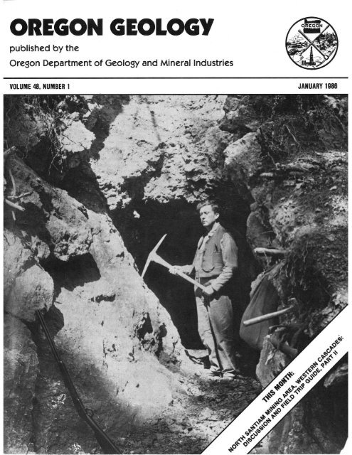
COVER PHOTO<br />
Typical early-day mine adit and miner. Photo was<br />
taken in the Blue River mining district in the Western<br />
Cascades. south of the North Santiam area. which is the<br />
subject of field trip guide beginning on next page. Photo<br />
courtesy <strong>Ore</strong>gon Historical Society.<br />
OIL AND GAS NEWS<br />
Columbia County - Mist Gas Field<br />
ARCO Columbia County 22-27. located in NW\t4 sec. 27. T.<br />
6 N .• R. 5 W .• in the vicinity of five recent gas completions. was<br />
spudded November 17. 1985. drilled to a total depth of 2.500 ft.<br />
and plugged and abandoned November 25, 1985.<br />
ARCO Columbia County 32-32. located in NE\t4 sec. 32. T. 6<br />
N., R. 5 W .• in the extreme west central part of the field. and I:y,;<br />
mi southwest of the nearest production. was completed<br />
November 13. 1985. as the 21st producing well in the field and<br />
ARCO's second success there this year. The well was drilled to a<br />
total depth of 2.711 ft.<br />
ARCO Crown Zellerbach 23-15. located near Pittsburg in<br />
the extreme southeast part of the field in SW\t4 sec. 15. T. 5 N ..<br />
R. 4 W .• was spudded November 26. 1985. and is drilling toward<br />
a permitted total depth of 3.500 ft. This well is just southeast of<br />
ARCO Crown Zellerbach 31-16. the most southeasterly<br />
producing well in the field.<br />
ARCO Crown Zellerbach 41-2. located in NE\t4 sec. 2. T. 5<br />
N .• R. 5 W .. was spudded November 5. 1985. drilledto a total<br />
depth of 2.109 ft. and plugged and abandoned November 12.<br />
1985.<br />
ARCO Longview Fibre 23-25. located in SW\t4 sec. 25. T. 6<br />
N .• R. 5 W .• was spudded December I. 1985. and is drilling<br />
toward a permitted total depth of 2.100 ft.<br />
Columbia County - Wildcat<br />
Exxon OPE Federal Com. I. located in sec. 3. T. 4 N .. R. 3<br />
W .• 2 mi north of Chapman in south-central Columbia County.<br />
was spudded September 2. 1985. and plugged and abandoned<br />
November 8. 1985. Permitted total depth was 12.000 ft. Total<br />
depth reached has not been released by the operator.<br />
Lincoln County<br />
Damon Petroleum Longview Fibre 3. located in NW\t4 sec.<br />
21. T. 9S .• R. II W .• wasspuddedSeptember27. 1985. drilled to<br />
a total depth of 3.040 ft. and plugged and abandoned November<br />
16. 1985. This is the third well drilled in this immediate vicinity<br />
since 1980. None have found production.<br />
Production: Mist Gas Field<br />
Cumulative: (1979-1984): 19.219.335 Mcf<br />
1985 Production (McO:<br />
January 271,717<br />
February 242.077<br />
March 301.885<br />
April 300,775<br />
May 364.072<br />
Cumulative (1985): 3.029.905<br />
June<br />
July<br />
August<br />
September<br />
Cumulative (l979-Sept. 1985): 22.249.240 Mcf<br />
Recent permits<br />
372.148<br />
385.157<br />
386.511<br />
405.563<br />
Permit Operator. well. Status. proposed<br />
no. API number Location total depth (ft)<br />
341 ARCO NE!4 sec. 35 Location;<br />
Longview Fibre 41-35 T. 6 N .. R. 5 W. 1.900.<br />
009-00182 Columbia County<br />
342 ARCO NE!4 sec. 27 Location;<br />
Columbia County 31-27 T. 6 N .. R. 5 W. 2.115.<br />
009-00183 Columbia County<br />
343 ARCO SE!4 sec. 25 Location;<br />
Longview Fibre 34-25 T. 6 N .. R. 5 W. 2.020.<br />
009-00184 Columbia County 0<br />
2<br />
OREGON GEOLOGY. VOLUME 48. NUMBER I. JANUARY 1986
North Santiam mining area, Western Cascades<br />
relations between alteration and volcanic<br />
stratigraphy: Discussion and field trip guide<br />
b,l' J. Michael Pollock and Michael L Cummings. <strong>Department</strong>ojGe%gy, PortlandSlale University. P.O. Box 751. Porrland, <strong>Ore</strong>gon<br />
97207<br />
Part II. Field trip guide*<br />
ROAD AND TRAIL LOG<br />
The route of the trip is shown in Figure I. Mileage is<br />
indicated in this log by italicized numbers. The first set of<br />
numbers is cumulative throughout the field trip: the numbers in<br />
parentheses indicate the mileage between points. The portion of<br />
the trip that goes through the Shiny Rock Mining Company<br />
claims is to be traveled on foot and is 4.7 mi each way. Faryour<br />
safety. avoid open mine ad its. Most are not maintained and are<br />
unstable and very dangerous.<br />
0.0 mi (0.0 mi) Proceed ens' on <strong>Ore</strong>gon Highway 22/rom its<br />
intersection wilh In/ers/ate 1-5 (exi/ 253) on Ihe soU/heasl edge<br />
0/ Salem. The highway climbs out of the Willamene Valley into<br />
the Waldo Hills. T hese hills. the Salem Hills to the southwest.<br />
and the Eola Hills west of Salem are underlain by flows of the<br />
Columbia River Basalt Group (CRBG).<br />
Thayer (1939) originally named these basalts the Stayton<br />
lavas. indicated that the rocks were similar to the CR BG. and<br />
tentatively correlated them with the CR BG. M. Beeson (oral<br />
communication. 1984) confirmed that the Stayton lavas are<br />
actually flows of the C RBG.<br />
Tolan and others (1984). in their studies of the Neogene<br />
history of the Columbia River. indicated that the oldest<br />
identified channel of the Columbia River passed near Stayton.<br />
through the Salem Hills. and possibly west to the Pacific Ocean.<br />
This channel developed during "Vantage time.·'a period of time<br />
lasting for se\'eral hundred thousand years or longer between<br />
the last eruptions of C RBG flows of the Grande Ronde Basalt<br />
(15.5 m.y. ago) and the first eruptions of the Frenchman Springs<br />
Member of the Wanapum Basalt. The firs! flow of the<br />
Frenchman Springs Member to reach this area. the Ginkgo<br />
flow. fo!~wed this ancestral channel. Hoffman (198 1) reported<br />
the thickness of the Ginkgo flow in the southeastern Salem Hills<br />
as 180 m.<br />
As the road climbs the hills. note the red-colored laterite<br />
soils developed on these basalts. In t he Salem Hills. ferruginous<br />
bauxite deposits have developed from the Frenchman Springs<br />
Member (Hoffman. 1981). These bau)(ite deposits are iron-rich<br />
and. in the Salem Hills. contain 13.4 million dry long tons of ore<br />
at 36.02 percent AbO.,: 4.17 percent Si01: and 32.49 percent<br />
Fe ~O, ( Hook. 1976).<br />
4.0 mi (4.0 mi) View to the east from the crest of the Waldo<br />
Hills toward the Cascade Range. The snow-covered peak in the<br />
distance is Mount Jefferson. one of the composite volcanos of<br />
the late High Cascade group of Priest and others ( 1984). Most of<br />
the hills in the intermediate distance are composed of rock s of<br />
the Western Cascade group of Priest and others (1984).<br />
/2.3 mi (8.3 mi) Sediments e)(posed in small outcrops are of<br />
the lllahe formation as defined by T hayer (1939). These<br />
sediments. which underlie the CR BG. arc well-bedded.<br />
tuffaceous marine sandstones that were deposited in a marine<br />
·Part 1. discussion. and references for both parts appeared in last<br />
month's ;~~ue (December (985).<br />
Mile 4/.5. One % pair of "slacks " between which Stack<br />
Creek flol1"s ondjrom which it derives irs nome.<br />
embayment that occupied the Willamene Valley until the early<br />
Miocene (Baldwin, 1981). Orr (1984) studied the informally<br />
named "Butte Creek beds" northeast of this locality and<br />
assigned them to the Oligocene. Coal and limestone deposits<br />
occur within these beds. The sediments were deformed to dips<br />
ranging from 10° to 12° prior to eruption oftheCRBG, which<br />
dips more gently (less than 3°).<br />
E)(amination of this outcrop reveals distinct reverse grading<br />
(finer particles near the base and increasing in size toward the<br />
tops of individual beds) resulting from the tendency of pumice<br />
10 float. Also present are abundant carbonized and uncarbonized<br />
plant materials.<br />
/4.5 mi (2.2 mi) Flows of the CRBG are e)(posed to the right<br />
and left of the highway as the road descends a small hill north of<br />
the town of Stayton. The road tothe right enlersSlayton.and in<br />
a quarry along the road. andcsitic volcanic rocks that may be the<br />
OREGON GEOLOGY. VOLUME 48. NUMBER I. JANUARY 1986<br />
3
To<br />
\V Portland<br />
SALEM<br />
~START<br />
To<br />
Albany<br />
N<br />
f<br />
Area shown in map B<br />
Map A<br />
Map B<br />
Gold<br />
C',.<br />
r=gI .:<br />
,~-----_ Whetstone Min ~------____ _------<br />
..\ .\.............. ....._!.'=- .....l.\------.... -----~:.. ~<br />
,<br />
-----, \ '<br />
\ ---",,-<br />
\ -.... '.:<br />
\ \<br />
4 .. Stop number<br />
--- Road<br />
-------- Tra i 1<br />
-River<br />
122231 Forest Se~vice road<br />
or tra i1 number<br />
---- Line of cross section<br />
Mine adit<br />
o Breccia pipes (Olson, 1978)<br />
Diorite intrusion (Olson, 1978).<br />
More than 50 smaller intrusions<br />
have been identified in the area<br />
(Olson, 1978; Pollock, 1985)<br />
To Detroit<br />
I mile<br />
Figure 1. Map A. Route o/field trip to North Santiam mining area, <strong>Ore</strong>gon. Map B. Locations o/key geologic/eatures andfield<br />
trip stops.<br />
4 OREGON GEOLOGY, VOLUME 48, NUMBER 1, JANUARY 1986
Mehama volcanics of Thayer (1936. 1939) are exposed.<br />
21.4 mi (6.9 mi) Mehama-Lyons junction. Continue on<br />
Highway 22/or 0.8 mi.<br />
22.2 mi {O.8 mi} Intersection with Little North Fork Road to<br />
the Little North Santiam Recreation Area along the Little<br />
North Santiam River. Turn left (northeast). The Little North<br />
Santiam River joins the North Santiam River immediately<br />
south of this intersection. Upper slopes of hills in this area are<br />
flows of the CRBG.<br />
25.2 mi (3.0 mi) Exposures of a basalt intracanyon flow are<br />
located to the left on the north side of the road. The source of the<br />
basalt is not known. It is not basalt of the CRBG (M. Beeson,<br />
oral communication, 1984) but may be a flow from a High<br />
Cascade basalt shield volcano. The intracanyon flow can be<br />
observed at several localities along the road up the valley,<br />
suggesting that the ancestral Little North Sanliam Ri ver was<br />
located in approximately its present location at the time the flow<br />
was erupted.<br />
27.2 mi (2.0 mi}The irregularity in the road surface isdueto<br />
active landslides. Deeply weathered volcaniclastic sediments in<br />
the cliff are involved in a particularly troublesome landslide. In<br />
the woods north of the road is the basah intracanyon flow. Steep<br />
contacts between diverse volcanic units are commonly<br />
associated with slope failures.<br />
28.3 mi (/.1 mi) BEWARE - the road takes a very tricky<br />
turn onto the bridge over the Little North Santiam Rive r.<br />
29.0 mi (0.7 mi) The basalt intracanyon flow is exposed in<br />
the quarry along the south side of the road. The jointing pattern<br />
is typical of the jointing developed in intracanyon flows.<br />
33.6 mi (4.6 mi) Bridge over the Little North Santiam River.<br />
Rocks of the Mehama volcanics (Thayer. 1936. 1939) crop out<br />
along the river valley.<br />
36.3 mi (2.7 mi) Entrance to Salmon Falls State Park.<br />
37.3 mi (/.0 mi) Intersection with Evans Mountain Road.<br />
Continue straight ahead on USFS Road 2209. Evans Mountain<br />
is named for a mysterious prospector known as "Old Man<br />
Evans" who was found tonured and murdered on his claims.<br />
Local legend has it that Evans was finding sufficient gold to<br />
support an elegant life style. As in all such mining legends, the<br />
location of his "mother lode" has not been found. This legend<br />
and others of the area are recounted by Roberts(date unknown)<br />
in her book, Elkhorn and Mehama: True Stories o/<strong>Ore</strong>gonians<br />
0/ the North Santiam. which is usually available in the general<br />
store in Mehama.<br />
38.4 mi (/. / mil Bridge over Henline Creek. North of USFS<br />
Road 2209 are abandoned workings on the Capital claim. The<br />
claim was patented as early as 1893, Most of the workings were<br />
caved by the 1930·s. Veins have an average strike of N. 500 W.<br />
and dip of7:5° to 80° SW. The veins are composed of a breccia of<br />
silicified andesite containing sericite and mesitite. an ironmagnesium<br />
carbonate. The breccia is cemented with stri ngers<br />
and veinlets of quartz with sulfides. chiefly sphalerite. There is<br />
minor galena and chalcopyrite (Callaghan and Buddington,<br />
1938).<br />
The Crown Mine. located to the south on the north flank of<br />
Elkhorn Mountain. was developed around 1927. Several veins<br />
were crossed in altered andesite. tuff. and volcanic breccia. A<br />
rhyolite is encountered near the contact of an intusive quartz<br />
diorite at the south end of the main crosscut. The Blind. Salem.<br />
Thirteen-Foot, and Winze Veins are along brecciated zones in<br />
which minor chalcopyrite. pyrite. and minor sphalerite are<br />
located within wall rocks mapped as tourmaline hornfels. These<br />
weakly mineralized veins strike from N. Sso W. to N. 6QO W.<br />
(Callaghan and Buddington. 1938).<br />
19./ mi(0.7 mil Intersection of USFS Roads 2207 and 2209.<br />
Stay on USFS Road 2209 straight ahead at this intersection.<br />
The road continues to follow the glaciated valley of the Little<br />
North Santiam River.<br />
39.5 mi (0.4 mi}The area between this outcrop and the Ruth<br />
Mine was mapped by Olson (1978). who concentrated on the<br />
mineralization and alteration associated with breccia pipes in<br />
the area. Olson informally divided these rocks into upper and<br />
lower members of the Sardine Formation. and the lower<br />
member crops out along the road. The rocks in the major road<br />
cuts are andesite tuffs and contai n accretionary lapil1i, abundant<br />
lithic fragments. possible pumice fragments. and crystal clasts.<br />
Epidote-lined fractures are present in the outcrop. and the<br />
common occurence of epidote in the tuffs is indicated by their<br />
yellow-green color.<br />
39.7 mi (0.2 mi}The lithic-crystal tuff exposed in these road<br />
cuts contains accretionary lapil1i.<br />
41.5 mi(J.8 mi) Road crosses Stack Creek. To the north isa<br />
scenic view of the twin stacks on Hen[ine Mountain.<br />
42.8 mi(J.3 mi}The road is very narrow and on the edge ofa<br />
steep cliff into Horn Creek.<br />
42.9 mi (0.1 mi) Road crosses Horn Creek after passing<br />
through a large pile of unconsolidated debris of glacial origin.<br />
The Black Eagle Mine is located at this point.<br />
43.4 mi {O.5 mi} Gate at the west edge of the claim block<br />
controlled by the Shiny Rock Mining Company. At this point<br />
park your car and proceed on foot. Tht Shiny Rock Mining<br />
Company i$ atumpting to presen't the histori(' mining artifacts<br />
of the district, and your cooptralion is appreciated. For your<br />
safety, avoid open mineadits, many o/which are not maintained<br />
and are unstable.<br />
41.8 mi (0.4 mi) Bridge over Gold Creek.<br />
41.9 mi (0.1 mi) SlOp t. A short side road leads to the adit of<br />
the Santiam I Mine on the Little North Santiam River. This<br />
• . ."."<br />
'-<br />
SlOP /. The adit of Santiam J Mine is one of hundreds 0/<br />
mine adits and pfOSptcts in the North Santiam mining area.<br />
,<br />
OREGON GEOLOGY. VOLUME 41. NUMBER I, JANUARY 1916
mine has also been known as the Minnie E. and the lotz-larsen<br />
at various times in its history. Most of the development work<br />
was done in 1915-1917. with some ore shipped in 1924. The vein<br />
strikes N.43° W. and dips 50 0 t080 0 NE. and has been mined on<br />
both sides of the river. <strong>Ore</strong> minerals are distributed along the<br />
vein. but there are four distinct narrow ore shoots. Chalcopyrite<br />
is the principal ore mineral; pyrite and sphalerite are<br />
subordinate. <strong>Ore</strong> grades ranged from L25 to 4.47 percent<br />
copper and 0.1 to 1.22 oz of gold per ton. locally the vein was<br />
up to 35 em wide and composed primarily of chalcopyrite<br />
(Callaghan and Buddington. 1938).<br />
The waterfall developed where the altered rocks of the vein<br />
were less resistant than the surrounding rocks. When the water<br />
level is low. the vein can be seen on the downstream end of the<br />
plunge pool. Waterfalls are common throughout the district and<br />
serve as one means of locating veins.<br />
is strongly sheared on a N. 10 0 W. trend on its western margin.<br />
This same relationship occurs for the porphyritic diorite dike<br />
near the l evel 5 pOTlal of the Ruth Mine.<br />
45.4 mi (0.7 mi) The collapsed buildings to the south of the<br />
road are part of the Merten sawmill built in 1943. Two steamdriven<br />
capstans believed to have been salvaged from the<br />
battleship <strong>Ore</strong>gon were used in this mill and remain on the site<br />
(Cox. 1985). One of the storage sheds is still standing near the<br />
east end of the mill site.<br />
45.6 mi (0.2 mil Stop 3. Take Ihe side rood thai crosses the<br />
Liute North Santlam River on an old bridge to Ihe south of the<br />
main road. This road leads to the site of holes drilled by Amoco<br />
Minerals under lease agreement with Shiny Roc k Mining<br />
Company. These holes are located in a cluster of tourmaline<br />
breccia pipes mapped by Olson ([978). The pipes. which are<br />
intensely altered and circula r to elliptical in plan. range from 10<br />
to over 100 m in length. Olson ( 1978) defined two types of<br />
breccia pipes: (I) shatter breccias of highly fractured rocks<br />
partially or completely altered to an assemblage of tourmaline.<br />
quartz. and sericite: and (2) ~characterized by highly-altered<br />
angular to subrounded clasts cemented by quartz: sericite.<br />
tourmaline. oxides, sulfides. and rarely carbonate." In the first<br />
type of breccia pipe. there was ]jule or no movement of<br />
fragments: in the second. the clasts have been displaced within<br />
the breccia. Zones of hyd rothermal alteration extend 50 to 100<br />
Stop I. The Minnie E. Vein on which the Santiam I Mine<br />
adit is located crosses the Litlle North Santiam River and has<br />
been mined on both sides. Waterfalls such as the one in this<br />
photo commonly jorm where streams are able to downcut easily<br />
into the altered rock oj the veins.<br />
44.0 mi (0. 1 mil Whetstone Mountain trailhead. The trail.<br />
which is not included as part of this log, proceeds north along<br />
Gold Creek and then east along the ridge to the top of<br />
Whetstone Mountain. This well-maintained trail makes a scenic<br />
side trip. but it is over 5 mi 10 the top and moderately steep. with<br />
no water. The top of Whetstone Mountain can also be reached<br />
from the Clackamas River drai nage. Maps are available from<br />
the Ripplebrook Ranger Station.<br />
44.3 mi (0.3 mil Stop 2. Halfbridge along the nOTlh bank of<br />
the little North Santiam River. An intrusion of porphyritic<br />
diorite fo rms a prominent cliff. Phenocrysts up to 8 mm long of<br />
blocky- to prismatic-shaped plagioclase comprises 15 percent of<br />
the rock. The dike has vesicles that have been filled by quartz.<br />
Plagioclase is altered to epidote, and hornblende is replaced by<br />
chlorite. The dike intrudes a lit hic-crystal tuff. and xenoliths are<br />
common along its margins.<br />
44.4 mi (0.1 mi) The Golden Bear mine Workings are in a vein<br />
of the Santiam group of claims. This adit is located in what<br />
Olson ( 1978) mapped as a tourmaline-bearing breccia pipe. The<br />
rocks are brecciated, silicified, and sericitized. An adil has been<br />
driven into the alteration for nearly 270 ft along a bearing ofN.<br />
35 0 W. (<strong>Ore</strong>gon <strong>Department</strong> o f <strong>Geology</strong> a nd M ineral<br />
Industries, 1951).<br />
44.7 mi (0.3 mil This porphyritic diorite intrusion was<br />
mapped by Olson (1978) as an intrusion genetically related to<br />
the large intrusion located in the center of the mining area and<br />
dated at [3.4 m.y. B.P. (Power a nd others. 198 1a). This<br />
intrusion follows aN. 30 0 W. trend along its eastern margin but<br />
,<br />
Stop 2. Half bridge, so called because the road is supported<br />
on one side by timbers and the other by the side o/the valley, was<br />
required where the highly resistant rock of a large intrusion was<br />
encountered by the early miners in the North Santiam mining<br />
area.<br />
OREGON GEOLOGY. VOLUME 48. NUMBER I. JANU ARY 1986
m beyond the margins of the pipes. The last event in formation<br />
of the pipes was the filling of open-space veins with quartz.<br />
Tourmaline occurs at this location as black rosettes. some of<br />
which surround chalcopyrite and are associated with secondary<br />
malachite. The best samples are found along the road and in<br />
small stream bed to the east. Return 10 the main road.<br />
45.7 mi (0.1 ml) Lure No.3 ad it is developed beneath the<br />
level of the road. The rocks are brecciated and silicified.<br />
Rosettes of tourmaline occur in the silicified materials, and<br />
pyrite and chalcopyrite occur in the alteration zone.<br />
46.6 mi(O.9 mi}Stop4. Jawbone Flats. <strong>Ore</strong>gon. This historic<br />
mining camp was built in the early 1930's and still serves as the<br />
operational headquarters for the mining activities in the district.<br />
Please stay out of the buildings and away from equipment. and<br />
respect the historic artifaclS that are present. On the east end oj<br />
Jawbone Flats. a bridge crosses Baflle Ax Creek about 0.25 mi<br />
north of where it joins Opal Creek to form the Little North<br />
Santiam River. Just across the bridge. a side road leads a short<br />
distance to the ore mill currently used by Shiny Rock Mining<br />
Company jor processing are from the Ruth Mine. Return to the<br />
main road.<br />
SlOp 4. Jawbone Flats was constructed in 1932 as a mining<br />
camp and still serves as the operational headquartersfor mining<br />
activity in theeasternportion of the North Santiam mining area.<br />
OJ the 30 or so original buildings, about half are still in use.<br />
46.8 mi (0.2 mil Stop 5. At this site are the ruins of the<br />
original ore mill constructed by the Amalgamated Mining<br />
Company in 1932. This mi ll collapsed under heavy snows in<br />
1949 (George. 1985). The original steam generator and other<br />
equipment are still visible. On the right side of the road was the<br />
old ore stockpile. and samples of ore from several of the veins in<br />
this part of the district can be found in this pile.<br />
47. J mi (0.3 mil An unmarked trail leads to the left. This was<br />
an old tram road used to haul ore from the Ruth Mine to the<br />
mill. Stay on the main road.<br />
47.5 mi (004 mil A side road joins the main road at a sharp<br />
angle. In the stream bed of Battle Ax Creek below this point are<br />
several veins and adits of the Bueche Group of claims. The ruins<br />
of an old building are located on the north side of the road. Stay<br />
on the main road.<br />
47.9 mi (0.4 mil Stop 6. The road crosses a small tributary of<br />
Battle Ax Creek. Exposed in the road cut to the west of the creek<br />
is an outcrop of a quartz-feldspar porphyry intrusion. The rocks<br />
are nearly white in color. with an abundance of quartz and<br />
feldspar phenocrysts. To the east of the creek. an intrusion of<br />
equigranular diorite intrudes a tuff of Unit A. The creek is<br />
located on a fa ult. and alteration along this fau lt is visible in<br />
both intrusions. At the level ofthe tram road visible below. float<br />
from a collapsed adit suggests that this vein contains more<br />
StOp 4. This operating are mill locatedjusl south of Jawbone<br />
flats was constructed in part jrom equipment salvaged from<br />
earlier mills in the mining area.<br />
chalcopyrite than is common in veins this far east in the district.<br />
48.0 mi (0.1 mi) Road intersection. The road to the right<br />
leads to the ad it of Level 4 of the Ruth Mine. Stay 10 the feft.<br />
48.1 mi (0.1 mil Road intersection. Stop 7. The road that<br />
turns sharply to the left leads down to Level 5 of the Ruth Mine<br />
while the main road continues a short distance to a small creek.<br />
Follow main roadtosmal/creek. Thiscreek. which is commonly<br />
called Ruth Creek. is downcut on the RU[h Vein. Adits have<br />
been driven on five levels of this vein. The open ad it visible<br />
above the road is the fourth level and is collapsed where it<br />
encounters the vein. 11 was a primary producer of ore in the<br />
1930·s. <strong>Ore</strong> was removed by ore cart and dumped intoa loading<br />
chute that is now collapsed at the road level. <strong>Ore</strong> samples from<br />
this adit can be collected in the stream.<br />
Return 10 the road intersection. Take the steep lower road<br />
down to Level 5 of the Ruth Mine. A small roadcut along this<br />
road is located in a porphyritic diorite intrusion that is strongly<br />
sheared on its west margin. When you reach the level of the nam<br />
road, STOP. To the right is LevelS of the Ruth Mine. This ad it<br />
is being actively mined at present. BEWA RE of mining<br />
activities. and stay out. Below the ad it in the creek bed. an<br />
intrusion of quartz-feldspar porphyry cuts a coarse block<br />
breccia of Unit A. J ust downstream. a dike of porphyritic diorite<br />
is visible as a resistant unit.<br />
This concludes the trail log. Return to the main road and 10<br />
your car by the same route. You may then return to Salem by the<br />
same rOute or take the optional route over French Creek Ridge.<br />
OPTIONAL TRIP BEGINS AT INTERSECTION OF<br />
USFS ROADS 2207 AND 2209<br />
At road log mile 39.1, take USFS Road 2207 to the southeast.<br />
Note: USFS Road 2107 is a logging road and not regularly<br />
maintained. It may be impassable in bad weather.<br />
3.3 mi (3.3 mil Bridge over the Little North Santiam River.<br />
On private land north of the road. Amoco Minerals Company<br />
has discovered a mineralized breccia pipe. The pipe is exposed in<br />
small outcrops on the north bank of Cedar Creek. Although<br />
discovery and drilling on the prospect were underway in 198 1.<br />
no public announcement has been made. and no published<br />
information on the pipe is available.<br />
5.1 mi (1.8 mi) Road crosses Cedar Creek.<br />
5.5 mi (0.4 mil Inlersection of USFS Roads 225 and 2207.<br />
Remain on USFS Road 2207 to the left.<br />
6.0 mi (0.5 mil Intersection of USFS Roads 125 and 2207.<br />
Stay on USFS Road 2207 to 1he right.<br />
9.2 mi (3.2 mil Epidote-lined fractures are seen to cut rocks<br />
OREGON GEOLOGY, VOLUME 41. NUMBER I. JANUARY 1986<br />
7
of the Sardine Formation in the roadcuts, The North Santiam<br />
mining area is approximately 3 mi to the north. Signs of hydrothermal<br />
alteration are common in the area. and epidote-lined<br />
fractures and propylitic alteration are typically noted.<br />
/0.2 mi (/.0 mi) A large dike crops out near where the road<br />
swings to follow the cirque wall to the east.<br />
lOA mi (0.2 mil Stop 8. Overlook of Opal Lake, the<br />
headwaters for Opal Creek. which joins Battle Ax Creek at<br />
Jawbone Flats to form the Little North Santiam River. Opal<br />
Lake occupies a cirque, and Opal Creek plunges over a series of<br />
three falls for a total drop in elevation of nearly 170 m. The<br />
upper falls is less than 0.25 mi northeast of the lake. The<br />
outcrops at this stop are bedded pyroclastic rocks that are<br />
probably rhyodacitic in composition. On the basis of White's<br />
( 1980b) lithologic descriptions, similar stratigraphic position.<br />
and elevation. it appears that these rocks are part of the Elk<br />
Lake formation. The o utcrops are well-layered, coarse<br />
heterolithic fragmental units of weathered, light-colored units<br />
interlayered with dark-colored. fragmental units of uniform<br />
clast types. The rocks are cut by a zeolite-coated fracture set that<br />
trends N. 40" W. and dips 70" SW. The fracture orientation isa<br />
common orientation encountered in the North Santiam mining<br />
area. The volcaniclastic rocks are intruded by subvolcanic<br />
inlrusions that cut the bedding at various angles.<br />
1l.6 mi (/.2 mi) White (1980b) mapped the crest of French<br />
Creek Ridge as the Elk Lake formation unconformably<br />
overlying rocks of the Sardine Formation. The thickness of the<br />
Elk Lake formation is ISO m atlhis locality. White defined two<br />
members of the formation: the lower consists of rhyodacitic<br />
flows and pyroclastic rocks, the upper of one or more thick<br />
flows of hornblende andesite. The pyroclastic units of the lower<br />
member are white or pale-pink'crystal-lithic tuff: flows are light<br />
gray and generally are flow banded. These lavas were probably<br />
erupted from a vent complex at the southwestern end of French<br />
Creek Ridge. This vent complex is the knob immediately<br />
southeast of the road at the crest of Frcnch Creek Ridge, White<br />
indicates that a small dome can be seen to intrude and to overlie<br />
the Sardine lavas at this point. A spine that is 10 m high occurs<br />
near the center of the dome. The upper member of the Elk Lake<br />
formation overlies the rhyodacitic rocks in the prominent knobs<br />
northeast of the pass at Martin Buttes and Byers Peak. These<br />
prominences are underlain by a single andesitic flow that is60 m<br />
thick and that displays a prominent colonnade. The andesites<br />
BOOK REVIEW<br />
by Daniel M. Johnson, Associate Professor 0/ Geography.<br />
Geography <strong>Department</strong>, Porrland State University. Portland.<br />
<strong>Ore</strong>gon 97207<br />
The Legacy of Ancient Lake Modoc: A Historical Geography of<br />
the Klamath Lakes Basin. by Sam and Emily Dicken, published<br />
by the authon, available from the University of <strong>Ore</strong>gon<br />
Bookstore,895 E. 13th, Eugene, OR 97403, or Shaw Stationery<br />
Company, 792 Main St" Klamath Falls. OR 97601. Price $10.<br />
For nearly 40 years, geographers Sam and Emily Dicken<br />
have been exploring and studying their adopted stale of <strong>Ore</strong>gon.<br />
They have shared the results of these efforts with the public<br />
through a series of books and <strong>journal</strong> articles. beginning with<br />
the first edition of <strong>Ore</strong>gon Geography published in 1950. In<br />
recent years we have been treated to Two Centuries 0/ <strong>Ore</strong>gon<br />
Geography: Vol I .• The Making 0/<strong>Ore</strong>gon(1979) and Vol. 2, A<br />
Regional Geography (1982). Their work on the historical<br />
geography of <strong>Ore</strong>gon has now been continued in a newly<br />
published book entitled The ugacy 0/ Ancient Lake Modoc: A<br />
contain abundant phenocrysts of plagioclase and less abundant<br />
but common phenocrysts of augite. Hypersthene and remnants<br />
of probable amphibole crystals are sparsely present as<br />
phenocrysts. The Elk Lake formation overlies both the Sardine<br />
and Breitenbush Formations with strong angular unconformity.<br />
Two K-Ar whole-rock ages for rocks of the Elk Lake formation<br />
are 9.8±O.46 m.y. and 11.8±0.4 m.y. (White. I 980b).<br />
13.3 mi (1.7 mil Stop 9, At this switchback, medium- to<br />
coarse-gra ined quartz diorite dikes intrude fine-grained ash<br />
beds of the Sardine Formalion. Hydrothermal alteration<br />
around the dikes has produced zeolitic alteration of the tuffs.<br />
Near the contact. the replacement is extensive but decreases in<br />
intensity away from the contact where the development of<br />
zeol ites becomes confined to fracture fillings and breccia<br />
cement. Analysis by X-ray diffraction indicates that laumontite<br />
is the main zeolite present. The contacts of the dikes are chilled<br />
against the wall, and xenoliths of tuff are incorporated into the<br />
dike. Abundant fine-grained xenoliths occur in the dike but,<br />
except for those near the contacts. are not derived from the<br />
immediate wall rocks. The contact strikes N. 10" W. and dips<br />
75" NE. Feldspar phenocrysts are strongly fractured, suggesting<br />
shattering such as might occur during hydrofracturing. These<br />
intrusions were emplaced at shallow depths.<br />
14.2 mi (0.9 mil Overview of Sardine Mountain, the type<br />
locality of the Sardine series as defined by Thayer (1939).<br />
Sardine Mountain is an eroded vent complex. Thin flows.<br />
bedded cinders. and radial dikes are considered to be a typical<br />
vent-facies assemblage exposed on the northern and western<br />
sides of the mountain (White. 1980b). On Hall Ridge<br />
immediately south of Sardine Mountain. flows are generally<br />
porphyritic, containing abundant plagioclase phenocrysts and<br />
lesser amounts of mafic phenocrysts. Most of the andesites have<br />
hypersthene and augite as phenocrysts. Lava flows compose<br />
from 50 to 70 percent of the formation in areas away from the<br />
vent complex. The rest of the formation is composed of lahars<br />
and lapilli tuff.<br />
l8A mi (4.2 mil Intersection with USFS Road 2223.<br />
Continue straight ahead. The sharp turn to the right would take<br />
you up Sardine Mountain to Tumble Lake.<br />
/8.6 mi (0.2 mil Intersection with <strong>Ore</strong>gon Highway 22, Turn<br />
right to return to Salem or le/t to go to the towns 0/ Detroil.<br />
Breitenbush Hot Springs, or Bend. 0<br />
Historical Geography 0/ the Klamath Lakes &sin (copyright<br />
1985 by the authors). This book represents a delightful blend of<br />
the two disciplines. but it differs from the Dickens' earlier work<br />
in that it focuses on one region of the state, the Klamath Lakes<br />
basin of south-central <strong>Ore</strong>gon. It amounts to a chronological<br />
description of both natural and human features. beginning with<br />
the period of exploration in the early 19th cen tury and<br />
continuing to 1985. Throughout. the authors have given careful<br />
attention to the perceptions of the region by those whoexplored<br />
and settled it.<br />
In the first chapter, the Dickens present an overview by the<br />
interesting technique of escorting the reader on an imaginary<br />
airplane flight. Only from this lofty perspective can the unity of<br />
the Klamath Lakes region be appreciated. As they point out. the<br />
"unifying feature is the lake plain. the bed of Old Lake Modoc.~<br />
a Pleistocene lake whose shoreline was drawn for the first time<br />
by Sam Dicken in an article in the November 1980 issue of<br />
<strong>Ore</strong>gon <strong>Geology</strong>. Modern lakes of the region. including<br />
<strong>Ore</strong>gon's largest (Upper Klamath Lake). are remnants of this<br />
larger Lake Modoc. (Continued on page /0, Book. Review)<br />
8<br />
OREGON GEOLOGV, VOLUME 48, NUMBER I, JANUARY 1986
ABSTRACTS<br />
The <strong>Department</strong> maintains a collection of theses and dissertations<br />
on <strong>Ore</strong>gon geology. From time to time, we print abstracts of<br />
new acquisitions that we feel are of general interest to our readers.<br />
GEOLOGY OF THE GREEN MOUNTAIN-YOUNGS<br />
RIVER AREA, CLATSOP COUNTY, NORTHWEST<br />
OREGON, by Carolyn Pugh Peterson (M.S., <strong>Ore</strong>gon State<br />
University, 1984 [thesis compl. 1983])<br />
The upper Eocene to lower Oligocene Oswald West<br />
mudstone is the oldest formation (informal) in the Green<br />
Mountain-Young's River area. This 1,663-m-thick hemipelagic<br />
sequence was deposited in a low-energy lower to upper slope<br />
environment in the Coast Range forearc basin. The formation<br />
ranges from the late Narizian to the early Zemorrian (?) in age<br />
and consists of thick-bedded bioturbated foraminiferal<br />
claystone and tuffaceous siltstone. Rare glauconitic sandstone<br />
beds also occur. In the eastern part of the study area, the upper<br />
part ofthe Oswald West mudstone is interbedded with the upper<br />
Refugian Klaskanine siltstone tongue. This informal unit<br />
consists of thick bioturbated sandy siltstone and silty sandstone<br />
that is a lateral deep-marine correlative of the deltaic to shallowmarine<br />
Pittsburg. Bluff Formation in the northeastern Coast<br />
Range.<br />
Discontinuous underthrusting of the Juan de Fuca oceanic<br />
plate at the base of the continental slope ofthe North American<br />
plate caused extensive uplift and subsidence along the <strong>Ore</strong>gon<br />
continental margin throughout the Cenozoic (Snavely and<br />
others, 1980). Initiation of <strong>Ore</strong>gon Coast Range uplift and<br />
accompanying erosion in the early Miocene, coupled with a<br />
global low stand of sea level (Vail and Mitchum, 1979), stripped<br />
most of the Oligocene (Zemorrian) Oswald West strata and in<br />
places much of the uppermost Eocene (upper Refugian) Oswald<br />
West strata in the field area, creating an unconformity.<br />
Deformation accompanying uplift included a system of eastwest-trending,<br />
oblique-slip faults.<br />
The Pillarian to Newportian-age Astoria Formation<br />
unconformably overlies the Oswald West mudstone and reflects<br />
deposition offshore from an open, storm-dominated coast<br />
during an early to middle Miocene transgression. Deposition of<br />
the Big Creek sandstone and Silver Point mudstone members of<br />
the Astoria Formation was controlled in part by submarine<br />
paleotopography that developed as a result of early Miocene<br />
deformation of the Oswald West strata. The up-to-200-m-thick<br />
Big Creek member varies from storm-deposited laminated<br />
sandstone to bioturbated mollusk-bearing silty sandstone that<br />
accumulated during fair-weather conditions on the inner to<br />
middle shelf. Overlying and perhaps in part laterally equivalent<br />
to the Big Creek member is the up-to-200-m-thick, deeper<br />
marine Silver Point member which consists of two lithologies:<br />
(I) interbedded, micaceous, turbidite sandstones and laminated<br />
mudstone; and (2) laminated bathyal mudstone that intertongues<br />
with and caps the turbidite sequences. The turbidite<br />
lithology is composed of two facies: (I) an underlying sand-rich<br />
facies, transitional between the shallow-marine Big Creek<br />
member and bathyal Silver Point strata, that was deposited on<br />
the outer shelf by storm-induced turbidity currents; and (2) an<br />
overlying sand-poor facies that was deposited at bathyal depths.<br />
The turbidite facies channelized and at some places removed the<br />
underlying Big Creek member and was deposited directly over<br />
Oswald West mudstone. The Astoria depositional sequence<br />
ranges from inner to outer neritic to bathyal facies and reflects<br />
continued deepening and anoxic depositional conditions ofthe<br />
Astoria basin through the middle Miocene. Big Creek and Silver<br />
Point sandstone petrology reflects volcanic sources from an<br />
ancestral western Cascades volcanic arc and metamorphic and<br />
granitic basement rocks farther east via an ancestral Columbia<br />
River drainage system. Diagenetic effects include: (a) formation<br />
of local calcite concretionary cements; and (b) formation of<br />
pore-filling smectite from alteration of volcanic rock fragments.<br />
At least six middle Miocene Columbia River Basalt Group<br />
intrusive episodes affected the Green Mountain-Youngs River<br />
area soon after deposition of the Astoria Formation. These<br />
basalt sills and dikes include normally polarized and reversely<br />
polarized low MgO-high Ti02, low MgO-low Ti02, and high<br />
MgO Grande Ronde basalt chemical subtypes and two<br />
porphyritic Frenchman Springs Member basalts (Ginkgo and<br />
Kelly Hollow(?) petrologic types). These basalt intrusions are<br />
virtually indistinguishable, based on chemistry, from subaerial<br />
flows of the plateau-derived Columbia River Basalt Group<br />
subtypes at nearby Nicolai Mountain and Porter Ridge. This<br />
correlation supports the Beeson and others (1979) hypothesis<br />
that the intrusions are not of local origin but formed by the<br />
invasion of the flows into the Miocene shoreline sediments to<br />
form "invasive" sills and dikes. Many dikes were emplaced<br />
along northeast- and northwest-trending faults, and some (i.e.,<br />
Ginkgo) cut older sills (Grande Ronde). A laterally extensive<br />
Frenchman Springs sill occurs under an older widespread<br />
Grande Ronde sill. From this older over younger intrusive<br />
relationship, a mechanism of "invasion" of sediment from<br />
overlying lava flows is difficult to envision.<br />
A pulse of rapid subduction starting in the middle Miocene<br />
(Snavely and others, 1980) was accompanied by renewed uplift,<br />
intensive block faulting, and continued development of the<br />
earlier formed Coast Range uplift. Left-oblique northeasttrending<br />
faults and conjugate northwest-trending right-oblique<br />
faults offset Grande Ronde and Frenchman Springs dikes and<br />
sills. This conjugate fault pattern may reflect oblique east-west<br />
convergence between the North American and Juan de Fuca<br />
plates. .<br />
The Silver Point mudstones and Oswald West mudstones<br />
have high total organic carbon contents, up to 5.5 percent, but<br />
are thermally immature and may act only as a source for<br />
biogenic gas(?) in the subsurface. Suitable reservoir rocks, such<br />
as the gas-producing upper Eocene Cowlitz Formation Clark<br />
and Wilson sandstone, may pinch out before reaching the Green<br />
Mountain-Youngs River area and are yet to be penetrated by<br />
exploration drilling. Post-middle Miocene fault traps abound in<br />
the area, although these faults might also breach subsurface<br />
natural gas reservoirs in the Green Mountain-Youngs River<br />
area.<br />
LANDSLIDE HAZARDS IN THE DALLES, WASCO<br />
COUNTY, OREGON, by Michael Hugh Sholin (M.S .. <strong>Ore</strong>gon<br />
State University. 1982)<br />
Human activity has led to the reactivation of portions of a<br />
Pleistocene landslide complex in The Dalles. <strong>Ore</strong>gon. Slope<br />
movements are in rocks of the Chenoweth Formation:<br />
agglomerate. conglomerate. tuff breccia. sandstone. and<br />
siltstone. Slope movements occur in at least two distinct areas in<br />
The Dalles. At one. the shear surface is defined by the contact<br />
between the Chenoweth Formation and the underlying<br />
Columbia River basalt. Data from inclinometer readings at the<br />
other area fail to reveal a well-defined shear surface. Slope<br />
movements in The Dalles cause tens of thousands of dollars<br />
worth of damage annually and may present a threat to human<br />
safety. So far. there has been little organized response to this<br />
hazard. 0<br />
OREGON GEOLOGY, VOLUME 48, NUMBER I, JANUARY 1986<br />
9
AVAILABLE DEPARTMENT PUBLICATIONS<br />
GEOLOGICAL MAP SERIES<br />
GMS-4: <strong>Ore</strong>gon gravity maps, onshore and offshore. 1967 "',..................................................... .<br />
GMS-5: Geologic map. Powers 15-minute quadrangle, Coos and Curry Counties. 1971 ................................ .<br />
GMS-6: Preliminary report on geology of part of Snake River canyon. 1974 ......................................... .<br />
GMS-8: Complete Bouguer gravity anomaly map. central Cascade Mountain Range. <strong>Ore</strong>gon. 1978 ...................... .<br />
GMS-9: Total-field aeromagnetic anomaly map, central Cascade Mountain Range. <strong>Ore</strong>gon. 1978 ....................... .<br />
GMS-IO: Low- to intermediate-temperature thermal springs and wells in <strong>Ore</strong>gon. 1978 ................................. .<br />
GMS-12: Geologic map of the <strong>Ore</strong>gon part of the Mineral 15-minute quadrangle, Baker County. 1978 .................... .<br />
GMS-13: Geologic map. Huntington and part of Olds Ferry 15-min. quadrangles, Baker and Malheur Counties. 1979 ...... .<br />
GMS-14: Index to published geologic mapping in <strong>Ore</strong>gon. 1898-1979. 1981 ............................................ .<br />
GMS-15: Free-air gravity anomaly map and complete Bouguer gravity anomaly map, north Cascades, <strong>Ore</strong>gon. 1981 ....... .<br />
GMS-16: Free-air gravity anomaly map and complete Bouguer gravity anomaly map, south Cascades, <strong>Ore</strong>gon. 1981 ....... .<br />
GMS-17: Total-field aeromagnetic anomaly map, south Cascades. <strong>Ore</strong>gon. 1981 ....................................... .<br />
GMS-18: <strong>Geology</strong> of Rickreall. Salem West. Monmouth. and Sidney 7!,1-min. quads., Marion/Polk Counties. 1981 ........ .<br />
GMS-19: <strong>Geology</strong> and gold deposits map. Bourne 7!,1-minute quadrangle, Baker County. 1982 .......................... .<br />
GMS-20: Map showing geology and geothermal resources, southern half. Burns 15-min. quad .. Harney County. 1982 ....... .<br />
GMS-21: <strong>Geology</strong> and geothermal resources map. Vale East 7!,1-minute quadrangle, Malheur County. 1982 ............... .<br />
GMS-22: <strong>Geology</strong> and mineral resources map. Mount Ireland 7!,1-minute quadrangle, Baker/Grant Counties. 1982 ......... .<br />
GMS-23: Geologic map. Sheridan 7!,1-minute quadrangle, Polk/Yamhill Counties. 1982 ................................. .<br />
GMS-24: Geologic map. Grand Ronde 7!,1-minute quadrangle. Polk/Yamhill Counties. 1982 ............................ .<br />
GMS-25: <strong>Geology</strong> and gold deposits map. Granite 7!,1-minute quadrangle, Grant County. 1982 .......................... .<br />
GMS-26: Residual gravity maps. northern. central. and southern <strong>Ore</strong>gon Cascades. 1982 ................................ .<br />
GMS-27: Geologic and neotectonic evaluation of north-central <strong>Ore</strong>gon: The Dalles IOx2° quadrangle. 1982 ............... .<br />
GMS-28: <strong>Geology</strong> and gold deposits map, Greenhorn 7!,1-minute quadrangle, Baker/Grant Counties. 1983 ................ .<br />
GMS-29: <strong>Geology</strong> and gold deposits map, NEY. Bates 15-minute quadrangle, Baker/Grant Counties. 1983 ................ .<br />
GMS-30: Geologic map, SEY. Pearsoll Peak 15-minute quadrangle. Curry/Josephine Counties. 1984 ..................... .<br />
G MS-31: <strong>Geology</strong> and gold deposits map. NWY. Bates 15-minute quadrangle, Grant County. 1984 ....................... .<br />
GMS-32: Geologic map. Wilhoit 7!,1-minute quadrangle, Clackamas/Marion Counties. 1984 ............................. .<br />
GMS-33: Geologic map. Scotts Mills 7!,1-minute quadrangle. Clackamas/Marion Counties. 1984 ......................... .<br />
GMS-34 Geologic map. Stayton NE 7!,1-minute quadrangle, Marion County. 1984 .................................... .<br />
GMS-35: <strong>Geology</strong> and gold deposits map. SWy. Bates 15-minute quadrangle, Grant County. 1984 ....................... .<br />
GMS-36: Mineral resources map of <strong>Ore</strong>gon. 1984 .................................................................. .<br />
G MS-37: Mineral resources map. offshore <strong>Ore</strong>gon. 1985 ........................................................... .<br />
GMS-40: Total-field aeromagnetic anomaly maps. Cascade Mountain Range. northern <strong>Ore</strong>gon. 1985 .................... .<br />
OTHER MAPS<br />
Reconnaissance geologic map. Lebanon 15-minute quadrangle. Linn/Marion Counties. 1956 .............................. 3.00<br />
Geologic map. Bend 30-minute quad .. and reconnaissance geologic map, central <strong>Ore</strong>gon High Cascades. 1957 ............... 3.00<br />
Geologic map of <strong>Ore</strong>gon west of 121st meridian (U.S. Geological Survey Map 1-325). 1961 ................................ 6.10<br />
Geologic map of <strong>Ore</strong>gon east of 121st meridian (U.S. Geological Survey Map 1-902). 1977 ................................ 6.10<br />
Landforms of <strong>Ore</strong>gon (relief map. 17x 12 in.) ........................................................................ 1.00<br />
<strong>Ore</strong>gon Landsat mosaic map (published by ERSAL. OSU). 1983 ............................ $8.00 over the counter; $11.00 mailed<br />
Geothermal resources of <strong>Ore</strong>gon (map published by NOAA). 1982 ..................................................... 3.00<br />
Geological highway map. Pacific Northwest region. <strong>Ore</strong>gon/Washington/part of Idaho (published by AAPG). 1973 ...... ,... 5.00<br />
Mist Gas Field Map. showing well locations. revised 4/85 (DOGAMI Open-File Report 0-84-2. ozalid print) ................ 5.00<br />
Northwest <strong>Ore</strong>gon. Correlation Section 24. Bruer & others. 1984 (published by AAPG) ................................... 5.00<br />
BULLETINS<br />
33. Bibliography of geology and mineral resources of <strong>Ore</strong>gon (1st supplement. 1937-45). 1947 ............................ 3.00<br />
35. <strong>Geology</strong> of the Dallas and Valset7 15-minute quadrangles. Polk County (map only). Revised 1964 ..................... 3.00<br />
36. Papers on Foraminifera from the Tertiary (v.2 [parts VI-VIII] only). 1949 .......................................... 3.00<br />
44. Bibliography of geology and mineral resources of <strong>Ore</strong>gon (2nd supplement. 1946-50). 1953 ........................... 3.00<br />
46. Ferruginous bauxite deposits. Salem Hills. Marion County. 1956 .................................................. 3.00<br />
53. Bibliography of geology and mineral resources of <strong>Ore</strong>gon (3rd supplement, 1951-55). 1962 ............................ 3.00<br />
61. Gold and silver in <strong>Ore</strong>gon. 1968 .............................................................................. 17.50<br />
62. Andesite Conference guidebook. 1968 .. . . . . . . . . . . . . . . . . . . . . . . . . . . .. . .. . ... . .. . . . . . . . . . . . . . . . . . . . . .. ... . ... . .. .. 3.50<br />
65. Proceedings of the Andesite Conference. 1969 .................................................................. 10.00<br />
67. Bibliography of geology and mineral resources of <strong>Ore</strong>gon (4th supplement. 1956-60). 1970 ............................ 3.00<br />
71. <strong>Geology</strong> of selected lava tubes. Bend area. Deschutes County. 1971 ................................................ 5.00<br />
78. Bibliography of geology and mineral resources of <strong>Ore</strong>gon (5th supplement. 1961-70). 1973 ............................ 3.00<br />
81. Environmental geology of Lincoln County. 1973 ................................................................ 9.00<br />
82. Geologic ha7ards of Bull Run Watershed. Multnomah and Clackamas Counties. 1974 ............................... 6.50<br />
83. Eocene stratigraphy of southwestern <strong>Ore</strong>gon. 1974 .............................................................. 4.00<br />
84. Environmental geology of western Linn County. 1974 ... . . . . . . . . . . . . . . . . . . . . . . . . . . .. . ... .... . .. . .. . . . . . . . . . . . . . .. 9.00<br />
85. Environmental geology of coastal Lane County. 1974 ............................................................ 9.00<br />
87. Environmental geology of western Coos and Douglas Counties. 1975 .............................................. 9.00<br />
88. <strong>Geology</strong> and mineral resources. upper Chetco River drainage. Curry and Josephine Counties. 1975 .................... 4.00<br />
89. <strong>Geology</strong> and mineral resources of Deschutes County. 1976 ....................................................... 6.50<br />
90. Land use geology of western Curry County. 1976 ............................................................... 9.00<br />
91. Geologic ha7ards of parts of northern Hood River, Wasco, and Sherman Counties. 1977 ............................. 8.00<br />
92. Fossils in <strong>Ore</strong>gon. A collection of reprints from the <strong>Ore</strong> <strong>Bin</strong>. 1977 ................................................. 4.00<br />
93. <strong>Geology</strong>. mineral resources. and rock material of Curry County. 1977 .............................................. 7.00<br />
94. Land use geology of central Jackson County. 1977 .............................................................. 9.00<br />
95. North American ophiolites (IGCP project). 1977 ................................................................ 7.00<br />
96. Magma genesis. AGU Chapman Conference on Partial Melting. 1977 .............................................. 12.50<br />
97. Bibliography of geology and mineral resources of <strong>Ore</strong>gon (6th supplement. 1971-75). 1978 ............................ 3.00<br />
98. Geologic ha7ards of eastern Benton County. 1979 ............................................................... 9.00<br />
99. Geologic ha7ards of northwestern Clackamas County. 1979 ....................................................... 10.00<br />
100. <strong>Geology</strong> and mineral resources of Josephine County. 1979 ....... . . . . . . . . . . .. . . .. . . .. . .. . .. . . . .. . . . . . . . . . . . . . . . . . . 9.00<br />
101. Geologic field trips in western <strong>Ore</strong>gon and southwestern Washington. 1980 ......................................... 9.00<br />
102. Bibliography of geology and mineral resources of <strong>Ore</strong>gon (7th supplement, 1976-79). 1981 ............................ 4.00<br />
SHORT PAPERS<br />
21. Lightweight aggregate industry in <strong>Ore</strong>gon. 1951 .................................................................. 1.00<br />
24. The Almeda Mine. Josephine County. 1967 ..................................................................... 3.00<br />
25. Petrography of Rattlesnake Formation at type area, central <strong>Ore</strong>gon. 1976 ........................................... 3.00<br />
27. Rock material resources of Benton County. 1978 ................................................................. 4.00<br />
Price No. copies Amount<br />
$ 3.00<br />
3.00<br />
6.50<br />
3.00<br />
3.00<br />
3.00<br />
3.00<br />
3.00<br />
7.00<br />
3.00<br />
3.00<br />
3.00<br />
5.00<br />
5.00<br />
5.00<br />
5.00<br />
5.00<br />
5.00<br />
5.00<br />
5.00<br />
5.00<br />
6.00<br />
5.00<br />
5.00<br />
8.00<br />
5.00<br />
4.00<br />
4.00<br />
4.00<br />
5.00<br />
8.00<br />
6.00<br />
4.00
AVAILABLE DEPARTMENT PUBLICATIONS (continued)<br />
MISCELLANEOUS PAPERS<br />
I. A description of some <strong>Ore</strong>gon rocks and minerals. 1950 ••..................................•......................<br />
5. <strong>Ore</strong>gon's gold placers. 1954 .•••.......•....................................•.....•.............................<br />
8. Available well records of oil and gas exploration in <strong>Ore</strong>gon. Revised 1982 .......................................... .<br />
II. Collection of articles on meteorites (reprints from <strong>Ore</strong> <strong>Bin</strong>). 1968 ................................................. ..<br />
15. Quicksilver deposits in <strong>Ore</strong>gon. 1971 .•••..........•.................................•..........................<br />
18. Proceedings of Citizens' Forum on Potential Future Sources of Energy, 1975 ••.•................•••••••...••......••<br />
19. Geothermal exploration studies in <strong>Ore</strong>gon, 1976. 1977 .......................................................... ..<br />
20. Investigations of nickel in <strong>Ore</strong>gon. 1978 •••..........•.................•.................••.•..•......•....••••••<br />
SPECIAL PAPERS<br />
I. Mission, goals, and programs of the <strong>Ore</strong>gon <strong>Department</strong> of <strong>Geology</strong> and Mineral Industries. 1978 ..•.................. 3.00<br />
2. Field geology, SW Broken Top quadrangle. 1978 ................................................................. 3.50<br />
3. Rock material resources, Clackamas, Columbia, Multnomah, and Washington Counties. 1978 ................•........ 7.00<br />
4. Heat flow of <strong>Ore</strong>gon. 1978 ..............•.••.•••...•.•••••..........•••••.............••..•.•.•....•.........• 3.00<br />
5. Analysis and forecasts of the demand for rock materials in <strong>Ore</strong>gon. 1979 ..................................•......... 3.00<br />
6. <strong>Geology</strong> of the La Grande area. 1980 ......••........•••....•.......•..............................•......•.••.. 5.00<br />
7. Pluvial Fort Rock Lake, Lake County. 1979 ..........•.......................................................... 4.00<br />
8. <strong>Geology</strong> and geochemistry of the Mount Hood volcano. 1980 ...................................................... 3.00<br />
9. <strong>Geology</strong> of the Breitenbush Hot Springs quadrangle. 1980 ......................................................... 4.00<br />
10. Tectonic rotation of the <strong>Ore</strong>gon Western Cascades. 1980 ....•••.••........•.•••...........••••••••..............•• 3.00<br />
II. Theses and dissertations on geology of <strong>Ore</strong>gon: Bibliography and index, 1899-1982. 1982 ...................•.......... 6.00<br />
12. Geologic linears of the northern part of the Cascade Range, <strong>Ore</strong>gon. 1980 .•.....•...•••••••.................•....... 3.00<br />
13. Faults and lineaments of the southern Cascades, <strong>Ore</strong>gon. 1981 ..................................................... 4.00<br />
14. <strong>Geology</strong> and geothermal resources of the Mount Hood area. 1982 ••••.•..•.•.•.••.................•.•..•.•..•...... 7.00<br />
15. <strong>Geology</strong> and geothermal resources of the central <strong>Ore</strong>gon Cascade Range. 1983 .••••.•...........••.•.•••.•....•...... 11.00<br />
16. Index to the <strong>Ore</strong> <strong>Bin</strong> (1939-1978) and <strong>Ore</strong>gon <strong>Geology</strong> (1979-1982). 1983 ............................................ 4.00<br />
17. Bibliography of <strong>Ore</strong>gon paleontology, 1792-1983. 1984 ..................•.....•........•....................•••... 6.00<br />
OIL AND GAS INVESTIGATIONS<br />
3. Preliminary identifications of Foraminifera, General Petroleum Long Bell #1 well. 1973 .........•••..••.•.•.••.•......<br />
4. Preliminary identifications of Foraminifera, E.M. Warren Coos County 1-7 well. 1973 .............•..•..........•.••.<br />
5. Prospects for natural gas, upper Nehalem River basin. 1976 ..........••.....................................•.....<br />
6. Prospects for oil and gas, Coos Basin. 1980 .........•...............•.....................................••....<br />
7. Correlation of Cenozoic stratigraphic units of western <strong>Ore</strong>gon and Washington. 1983 .•.••••••........................<br />
8. Subsurface stratigraphy of the Ochoco Basin, <strong>Ore</strong>gon. 1984 ...............•....................•••..•.••.••.......<br />
9. Subsurface biostratigraphy, east Nehalem Basin. 1983 ........................................................... ..<br />
10. Mist Gas Field: Exploration and development, 1979-1984 ........................................................ .<br />
II. Biostratigraphy of exploratory weIrs, western Coos, Douglas, and Lane Counties. 1984 ............•...••••••.••.......<br />
12. Biostratigraphy of exploratory wells, northern Willamette Basin. 1984 ....•••..••.............•.....•••.••.••...•...<br />
13. Biostratigraphy of exploratory wells, southern Willamette Basin. 1985 ....•............••.....•••••...••..........••<br />
NEW!t4. Oil and gas investigation of the Astoria basin, Clatsop and north Tillamook Counties. 1985 ......•..••••.•.....•..•.••<br />
MISCELLANEOUS PUBLICATIONS<br />
Mining claims (State laws governing quartz and placer claims) ........................................................ 1.00<br />
Back issues of <strong>Ore</strong> <strong>Bin</strong> •••••........•...............•....................•.......•.•.•••••• 50¢ over the counter; $1.00 mailed<br />
Back issues of <strong>Ore</strong>gon <strong>Geology</strong> •.•••••.......•••••••••••.....•••••••........•••••••........• 75¢ over the counter; $1.00 mailed<br />
Colored postcard: <strong>Geology</strong> of <strong>Ore</strong>gon .............................................................................. 0.10<br />
Prices No. copies<br />
$ 1.00<br />
1.00<br />
4.00<br />
3.00<br />
3.00<br />
3.00<br />
3.00<br />
5.00<br />
3.00<br />
3.00<br />
5.00<br />
9.00<br />
8.00<br />
7.00<br />
6.00<br />
4.00<br />
6.00<br />
6.00<br />
6.00<br />
7.00<br />
Amount<br />
Sepante price lists for open-rue reports, leoihermal enerlY studies, tour luides, reereatlonallOld mininlinformation, and non-<strong>Department</strong>al maps and reports wRi be<br />
mailed upon request.<br />
OREGON GEOLOGY<br />
910 State Office Building, 1400 SW Fifth Avenue,<br />
Portland, <strong>Ore</strong>gon 97201<br />
Second Class Matter<br />
POSTMASTER: Form 3579 requested<br />
PUBLICATIONS ORDER<br />
Fill in appropriate blanks and send sheet to <strong>Department</strong>.<br />
Minimum mail order $1.00. All sales are final. Publications are sent<br />
postpaid. Payment must accompany orders of less than $50.00. Foreign<br />
orders: Please remit in U.S. dollars.<br />
NAME _______________ ___<br />
ADDRESS _________________________ _<br />
______________ ZIP ______ _<br />
Amount enclosed $<br />
OREGON GEOLOGY<br />
__ Renewal __ New Subscription __ Gift<br />
__ 1 Year ($6.00) __ 3 Years ($15.00)<br />
NAME _________________<br />
ADDRESS ______________<br />
_ ____________ ZIP _______<br />
If gift: From


