

July 1993 - Oregon Department of Geology and Mineral Industries
July 1993 - Oregon Department of Geology and Mineral Industries
July 1993 - Oregon Department of Geology and Mineral Industries

You also want an ePaper? Increase the reach of your titles
YUMPU automatically turns print PDFs into web optimized ePapers that Google loves.
Glaciation in the central Coast Range <strong>of</strong> <strong>Oregon</strong><br />
by Ewart M. Baldwin, <strong>Department</strong> o/Geological Sciences, University o/<strong>Oregon</strong>, Eugene, <strong>Oregon</strong> 97403<br />
INTRODUCTION<br />
Glacial cirques are present along the northern edges <strong>of</strong> several <strong>of</strong><br />
the prominent, sill-capped peaks in the central Coast Range <strong>of</strong><br />
<strong>Oregon</strong> (Figure I). These were first observed by the writer when he<br />
was mapping in the Dallas <strong>and</strong> Valsetz quadrangles l (Baldwin,<br />
1947). In 1945, a disastrous forest fire had swept northward from<br />
the Valsetz area, denuding most <strong>of</strong> the upper Boulder Creek <strong>and</strong><br />
Laurel Mountain area. Salvage logging had removed rnany <strong>of</strong> the<br />
remaining blackened trees, so that the area was quite bare <strong>and</strong> cirques<br />
were easy to see. Today, the area is covered by a young forest, which,<br />
while it is favorable for the economic future <strong>of</strong> <strong>Oregon</strong>, hides much<br />
<strong>of</strong> the geologic evidence. Later mapping in the Spirit Mountain (now<br />
Gr<strong>and</strong> Ronde) quadrangle (Baldwin <strong>and</strong> Roberts, 1952) revealed<br />
evidence <strong>of</strong> glaciation on the north edge <strong>of</strong> Saddleback Mountain in<br />
the extreme south end <strong>of</strong> the quadrangle. Saddleback Mountain<br />
extends across the Salmon River into the southeastern comer <strong>of</strong> the<br />
Hebo quadrangle.<br />
The glacial cirques are nearly all carved in late Oligocene-early<br />
Miocene sills, although some <strong>of</strong> them may have been eroded to the<br />
middle Eocene sedimentary rocks below. Stream flow at the extreme<br />
headwaters <strong>of</strong> the streams is not sufficient to excavate the rounded<br />
cirques, nor is there the V-shaped valley that running water would<br />
produce. Some ponds <strong>and</strong> small lakes may be the result <strong>of</strong> l<strong>and</strong>sliding,<br />
but the cirques under discussion are in solid intrusive granophyric<br />
gabbro seldom given to sliding. If a block did slide, the debris<br />
should contain largely blocks <strong>of</strong> the gabbro, whereas debris down<br />
slope differs in size <strong>and</strong> distribution <strong>of</strong> rock types. It is true that<br />
boulders <strong>of</strong> gabbro a foot or two in diameter are common at the base<br />
<strong>of</strong> the steeper slopes, but these likely were pushed or carried by ice<br />
to a lower level. Gravity might cause some <strong>of</strong> these boulders to float,<br />
even if there were no glaciation, but such boulders make up a small<br />
part <strong>of</strong> the unconsolidated debris down slope.<br />
Marys Peak is 4,097 ft in altitude, the highest peak in the Coast<br />
Range. Laurel Mountain is more than 3,700 ft high, <strong>and</strong> Mount<br />
Hebo reaches 3,153 ft. None <strong>of</strong> these altitudes compare with the<br />
general level <strong>of</strong> glaciation in the Cascade Range to the east. However,<br />
during the Wisconsin stage <strong>of</strong> the Pleistocene glaciation,<br />
Puget Sound was filled with a thick sheet <strong>of</strong> ice as far south as<br />
Tenino near Olympia, <strong>and</strong> alpine glaciation was widespread in the<br />
Olympic Peninsula <strong>and</strong> in the Cascade Range <strong>of</strong> Washington <strong>and</strong><br />
<strong>Oregon</strong>. There should have been a regional chill affecting other<br />
parts <strong>of</strong> the Northwest such as the Coast Range <strong>of</strong> <strong>Oregon</strong>. Maximum<br />
glaciation brought lowering <strong>of</strong> the sea by as much as 400 ft,<br />
<strong>and</strong> since altitude is calculated from sea level, all the peaks were<br />
400 ft higher during maximum cooling, which might help in<br />
explaining the presence <strong>of</strong> glaciers.<br />
The <strong>Oregon</strong> Coast Range is an area <strong>of</strong> great precipitation.<br />
Valsetz, when it existed as a weather station, frequently recorded<br />
120-150 in. <strong>of</strong> precipitation per year. When the writer was working<br />
in the area, frequent winter snow storms would bring several feet<br />
1 Unless specified, quadrangle names mentioned in this paper refer to<br />
I5-minute quadrangles. For easier reference to current map indexes, the<br />
following lists the 7'1,-minute quadrangles into which the I5-minute quadrangles<br />
have been divided. Beginning at the northwest corner, clockwise:<br />
Euchre Mountain: Devils Lake, StOI/ Mountain, Euchre Mountain, Mowrey<br />
L<strong>and</strong>ing.<br />
Gr<strong>and</strong> Ronde: Niagara Creek, Springer Mountain, Gr<strong>and</strong> Ronde, Midwa):<br />
Hebo: Nestucca Bay, Hebo, Dolph, Neskowin.<br />
Man's Peak: Nortons, Summit, Marys Peak, Harlan.<br />
Vals~tz: Warnicke Creek, Laurel Mountain, Fanno Ridge, Valset~. -ed.<br />
: I<br />
Eugene o<br />
44°~~------~4r--------~~<br />
o 50 100 MILES<br />
~<br />
.,-JI~! -,--+1 --,-----,--I ------,--__ .~<br />
I I I 1 1<br />
o 50 100 K I L 0 M ET E R S<br />
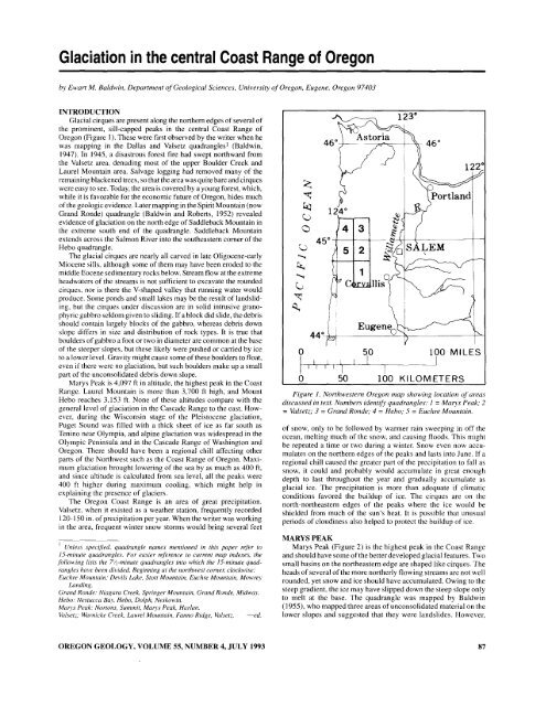
Figure 1. Northwestern <strong>Oregon</strong> map showing location 0/ areas<br />
discussed in text. Numbers identify quadrangles: 1 = Marys Peak; 2<br />
= Valsetz; 3 = Gr<strong>and</strong> Ronde; 4 = Hebo; 5 = Euchre Mountain.<br />
<strong>of</strong> snow, only to be followed by warmer rain sweeping in <strong>of</strong>f the<br />
ocean, melting much <strong>of</strong> the snow, <strong>and</strong> causing floods. This might<br />
be repeated a time or two during a winter. Snow even now accumulates<br />
on the northern edges <strong>of</strong> the peaks <strong>and</strong> lasts into June. If a<br />
regional chill caused the greater part <strong>of</strong> the precipitation to fall as<br />
snow, it could <strong>and</strong> probably would accumulate in great enough<br />
depth to last throughout the year <strong>and</strong> gradually accumulate as<br />
glacial ice. The precipitation is more than adequate if climatic<br />
conditions favored the buildup <strong>of</strong> ice. The cirques are on the<br />
north-northeastern edges <strong>of</strong> the peaks where the ice would be<br />
shielded from much <strong>of</strong> the sun's heat. It is possible that unusual<br />
periods <strong>of</strong> cloudiness also helped to protect the buildup <strong>of</strong> ice.<br />
MARYS PEAK<br />
Marys Peak (Figure 2) is the highest peak in the Coast Range<br />
<strong>and</strong> should have some <strong>of</strong> the better developed glacial features. Two<br />
small basins on the northeastern edge are shaped like cirques. The<br />
heads <strong>of</strong> several <strong>of</strong> the more northerly flowing streams are not well<br />
rounded, yet snow <strong>and</strong> ice should have accumulated. Owing to the<br />
steep gradient, the ice may have slipped down the steep slope only<br />
to melt at the base. The quadrangle was mapped by Baldwin<br />
(1955), who mapped three areas <strong>of</strong> unconsolidated material on the<br />
lower slopes <strong>and</strong> suggested that they were l<strong>and</strong>slides. However,<br />
OREGON GEOLOGY, VOLUME 55, NUMBER 4, JULY <strong>1993</strong><br />
87


