

July 1993 - Oregon Department of Geology and Mineral Industries
July 1993 - Oregon Department of Geology and Mineral Industries
July 1993 - Oregon Department of Geology and Mineral Industries

Create successful ePaper yourself
Turn your PDF publications into a flip-book with our unique Google optimized e-Paper software.
locks <strong>of</strong> sill that would have resulted when pieces <strong>of</strong><br />
the rim broke <strong>of</strong>f were not present. Scattered rounded<br />
boulders were present throughout the material. Sills in<br />
the Coast Range are quite stable, <strong>and</strong> at no place in the<br />
study area could the rounded heads <strong>of</strong> streams be attributed<br />
to sliding <strong>of</strong> sizable masses <strong>of</strong> gabbro. The writer<br />
now has assigned the unconsolidated material to glacial<br />
delivery <strong>and</strong> not to l<strong>and</strong>slides.<br />
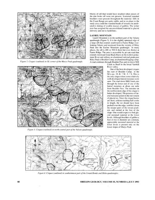
LAUREL MOUNTAIN<br />
Laurel Mountain is in the northern part <strong>of</strong> the Valsetz<br />
quadrangle (Figure 3). It is the slightly upturned edge <strong>of</strong><br />
a large sill that extends southward to Fanno Ridge overlooking<br />
Valsetz <strong>and</strong> westward from the vicinity <strong>of</strong> Riley<br />
Peak into the Euchre Mountain quadrangle. In many<br />
places, the sill is 400 or 500 ft thick but even thicker at<br />
Fanno Ridge. The area is accessible by private road that<br />
extends westward from Black Rock on the Little Luckiamute<br />
River <strong>and</strong> utilizes an ab<strong>and</strong>oned railroad grade past<br />
Riley Peak to Boulder Camp. an ab<strong>and</strong>oned logging camp.<br />
Figure 2. Cirques (outlined) in SE corner <strong>of</strong> the Marys Peak quadrangle. A road continues through Boulder Pass <strong>and</strong> on down Mill<br />
Creek to Buell in the broad Yamhill<br />
River valley.<br />
One <strong>of</strong> the best developed cirques<br />
lies east <strong>of</strong> Boulder Camp, in the<br />
SEY4 sec. 19, R. 7 w., T. 7 S. This is<br />
the only cirque where some relatively<br />
well-developed lateral moraines were<br />
seen. The road down Mill Creek cuts<br />
through the lower end <strong>of</strong> one <strong>of</strong> the<br />
lateral moraines at about one mile<br />
from Boulder Pass. The moraine on<br />
the northwestern edge <strong>of</strong> the cirque is<br />
better developed. The presence <strong>of</strong>lateral<br />
moraines points to the movement<br />
<strong>of</strong> glacial ice. Since the cirque basins<br />
are short, seldom reaching half a mile<br />
in length, the ice should have been<br />
pushed over the edge, tumbled down<br />
the steeper parts <strong>of</strong> the stream gradient,<br />
<strong>and</strong> melted at the foot <strong>of</strong> the<br />
slope. One would expect to find glacial<br />
morainal material at the lower<br />
levels. Although boulders <strong>of</strong> gabbro a<br />
foot or two in diameter are common,<br />
appreciable morainal material at the<br />
lower levels is present only on the<br />
lower slopes <strong>of</strong> Marys Peak.<br />
Figure 3. Cirques (outlined) in north-central part <strong>of</strong> the Valsetz quadrangle.<br />
Figure 4. Cirques (outlined) in southernmost part <strong>of</strong> the Gr<strong>and</strong> Ronde <strong>and</strong> Hebo quadrangles.<br />
88<br />
OREGON GEOLOGY, VOLUME 55, NUMBER 4, JULY <strong>1993</strong>


