

Central Queensland Sandstone Belt parks visitor guide (PDF, 4.0M)
Central Queensland Sandstone Belt parks visitor guide (PDF, 4.0M)
Central Queensland Sandstone Belt parks visitor guide (PDF, 4.0M)

Create successful ePaper yourself
Turn your PDF publications into a flip-book with our unique Google optimized e-Paper software.
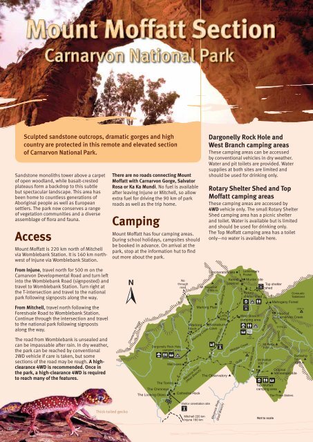
Sculpted sandstone outcrops, dramatic gorges and high<br />
country are protected in this remote and elevated section<br />
of Carnarvon National Park.<br />
<strong>Sandstone</strong> monoliths tower above a carpet<br />
of open woodland, while basalt-crested<br />
plateaus form a backdrop to this subtle<br />
but spectacular landscape. This area has<br />
been home to countless generations of<br />
Aboriginal people as well as European<br />
settlers. The park now conserves a range<br />
of vegetation communities and a diverse<br />
assemblage of flora and fauna.<br />
Access<br />
Mount Moffatt is 220 km north of Mitchell<br />
via Womblebank Station. It is 160 km northwest<br />
of Injune via Womblebank Station.<br />
There are no roads connecting Mount<br />
Moffatt with Carnarvon Gorge, Salvator<br />
Rosa or Ka Ka Mundi. No fuel is available<br />
after leaving Injune or Mitchell, so allow<br />
extra fuel for driving the 90 km of park<br />
roads as well as the trip home.<br />
Camping<br />
Mount Moffatt has four camping areas.<br />
During school holidays, campsites should<br />
be booked in advance. On arrival at the<br />
park, stop at the information hut to find<br />
out more about the park.<br />
Dargonelly Rock Hole and<br />
West Branch camping areas<br />
These camping areas can be accessed<br />
by conventional vehicles in dry weather.<br />
Water and pit toilets are provided. Water<br />
supplies at both sites are limited and<br />
should be used for drinking only.<br />
Rotary Shelter Shed and Top<br />
Moffatt camping areas<br />
These camping areas are accessed by<br />
4WD vehicle only. The small Rotary Shelter<br />
Shed camping area has a picnic shelter<br />
and toilet. Water is available but is limited<br />
and should be used for drinking only.<br />
The Top Moffatt camping area has a toilet<br />
only—no water is available here.<br />
From Injune, travel north for 500 m on the<br />
Carnarvon Developmental Road and turn left<br />
into the Womblebank Road (signposted) and<br />
travel to Womblebank Station. Turn right at<br />
the T-intersection and travel to the national<br />
park following signposts along the way.<br />
From Mitchell, travel north following the<br />
Forestvale Road to Womblebank Station.<br />
Continue through the intersection and travel<br />
to the national park following signposts<br />
along the way.<br />
The road from Womblebank is unsealed and<br />
can be impassable after rain. In dry weather,<br />
the park can be reached by conventional<br />
2WD vehicle if care is taken, but some<br />
sections of the road may be rough. A highclearance<br />
4WD is recommended. Once in<br />
the park, a high-clearance 4WD is required<br />
to reach many of the features.<br />
Chesterton Range<br />
Dargonelly Rock Hole<br />
camping area<br />
Mail boxes<br />
Marlong Creek<br />
Maranoa River<br />
(West Branch)<br />
The Tombs<br />
The Chimneys<br />
The Looking Glass<br />
Cathedral Rock<br />
2<br />
No<br />
through<br />
road<br />
5<br />
3<br />
3<br />
Marlong<br />
Arch<br />
6<br />
Mt Sugarloaf<br />
1154 m<br />
Marlong Plain<br />
9<br />
2<br />
Incineration site<br />
Marlong Creek<br />
Lot’s<br />
Wife<br />
Kookaburra<br />
Cave<br />
Long Gully<br />
The Observatory<br />
7<br />
Kenniff<br />
Lookout<br />
2<br />
Mistake Creek<br />
15<br />
2<br />
Brandy<br />
5<br />
Lethbridge’s<br />
Pocket<br />
Murder site<br />
Rotary<br />
shelter shed<br />
West Branch<br />
camping area<br />
Gully<br />
One Mile Creek<br />
1141 m<br />
7<br />
1137 m<br />
Top shelter<br />
shed<br />
2<br />
2<br />
Boot Creek<br />
Mt Moffatt<br />
1097 m<br />
Top Moffatt<br />
camping area<br />
Mahogany Forest<br />
Great<br />
Mt Percy<br />
1151 m<br />
Head of<br />
Carnarvon Creek<br />
1174 m<br />
Dividing<br />
Carnarvon Creek<br />
Range<br />
Original<br />
homestead site<br />
The Three Sisters<br />
Consuelo<br />
Tableland<br />
1232 m<br />
Battleship<br />
Spur<br />
1074 m<br />
Thick-tailed gecko<br />
Visitor orientation site<br />
Mitchell 220 km<br />
Injune 160 km<br />
Maranoa River<br />
(East Branch)<br />
Not to scale<br />
10


