

Central Queensland Sandstone Belt parks visitor guide (PDF, 4.0M)
Central Queensland Sandstone Belt parks visitor guide (PDF, 4.0M)
Central Queensland Sandstone Belt parks visitor guide (PDF, 4.0M)

You also want an ePaper? Increase the reach of your titles
YUMPU automatically turns print PDFs into web optimized ePapers that Google loves.
Photo: Brendan Moodie, NPRSR.<br />
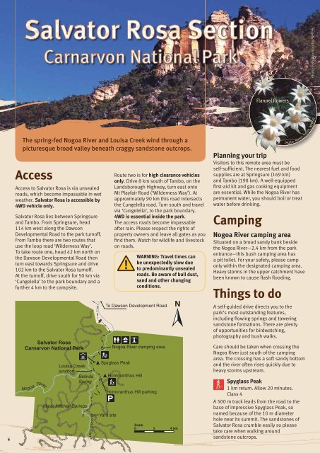
Flannel flowers<br />
6<br />
The spring-fed Nogoa River and Louisa Creek wind through a<br />
picturesque broad valley beneath craggy sandstone outcrops.<br />
Access<br />
Access to Salvator Rosa is via unsealed<br />
roads, which become impassable in wet<br />
weather. Salvator Rosa is accessible by<br />
4WD vehicle only.<br />
Salvator Rosa lies between Springsure<br />
and Tambo. From Springsure, head<br />
114 km west along the Dawson<br />
Developmental Road to the park turnoff.<br />
From Tambo there are two routes that<br />
use the loop road ‘Wilderness Way’.<br />
To take route one, head 42 km north on<br />
the Dawson Developmental Road then<br />
turn east towards Springsure and drive<br />
102 km to the Salvator Rosa turnoff.<br />
At the turnoff, drive south for 50 km via<br />
‘Cungelella’ to the park boundary and a<br />
further 4 km to the campsite.<br />
Salvator Rosa<br />
Carnarvon National Park<br />
Nogoa River<br />
Louisa Creek<br />
junction<br />
Belinda<br />
Spring<br />
Major Mitchell Springs<br />
Louis a Cre e k<br />
To Dawson Development Road<br />
Spyglass Peak<br />
Yard site<br />
Route two is for high clearance vehicles<br />
only. Drive 8 km south of Tambo, on the<br />
Landsborough Highway, turn east onto<br />
Mt Playfair Road (‘Wilderness Way’). At<br />
approximately 90 km this road intersects<br />
the Cungelella road. Turn south and travel<br />
via ‘Cungelella’, to the park boundary.<br />
4WD is essential inside the park.<br />
The access roads become impassable<br />
after rain. Please respect the rights of<br />
property owners and leave all gates as you<br />
find them. Watch for wildlife and livestock<br />
on roads.<br />
Nogoa River camping area<br />
Homoranthus Hill<br />
Homoranthus Hill parking<br />
WARNING: Travel times can<br />
be unexpectedly slow due<br />
to predominantly unsealed<br />
roads. Be aware of bull dust,<br />
sand and other changing<br />
conditions.<br />
Scale<br />
0<br />
2 4 km<br />
Photo: Karen Smith, NPRSR.<br />
Planning your trip<br />
Visitors to this remote area must be<br />
self-sufficient. The nearest fuel and food<br />
supplies are at Springsure (169 km)<br />
and Tambo (198 km). A well-equipped<br />
first-aid kit and gas cooking equipment<br />
are essential. While the Nogoa River has<br />
permanent water, you should boil or treat<br />
water before drinking.<br />
Camping<br />
Nogoa River camping area<br />
Situated on a broad sandy bank beside<br />
the Nogoa River—2.4 km from the park<br />
entrance—this bush camping area has<br />
a pit toilet. For your safety, please camp<br />
only within the designated camping area.<br />
Heavy storms in the upper catchment have<br />
been known to cause flash flooding.<br />
Things to do<br />
A self-<strong>guide</strong>d drive directs you to the<br />
park’s most outstanding features,<br />
including flowing springs and towering<br />
sandstone formations. There are plenty<br />
of opportunities for birdwatching,<br />
photography and bush walks.<br />
Care should be taken when crossing the<br />
Nogoa River just south of the camping<br />
area. The crossing has a soft sandy bottom<br />
and the river often rises quickly due to<br />
heavy storms upstream.<br />
Spyglass Peak<br />
1 km return. Allow 20 minutes.<br />
Class 4<br />
A 500 m track leads from the road to the<br />
base of impressive Spyglass Peak, so<br />
named because of the 10 m diameter<br />
hole near its summit. The sandstones of<br />
Salvator Rosa crumble easily so please<br />
take care when walking around<br />
sandstone outcrops.


