

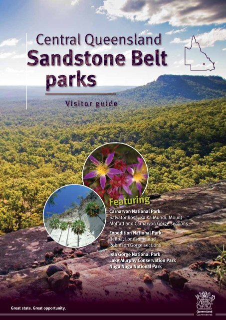
Central Queensland Sandstone Belt parks visitor guide (PDF, 4.0M)
Central Queensland Sandstone Belt parks visitor guide (PDF, 4.0M)
Central Queensland Sandstone Belt parks visitor guide (PDF, 4.0M)

Create successful ePaper yourself
Turn your PDF publications into a flip-book with our unique Google optimized e-Paper software.
Featuring<br />
Carnarvon National Park:<br />
Salvator Rosa, Ka Ka Mundi, Mount<br />
Moffatt and Carnarvon Gorge sections<br />
Expedition National Park:<br />
Beilba, Lonesome and<br />
Robinson Gorge sections<br />
Isla Gorge National Park<br />
Lake Murphy Conservation Park<br />
Nuga Nuga National Park<br />
Great state. Great opportunity.
Carnarvon Gorge<br />
The <strong>Central</strong> <strong>Queensland</strong> <strong>Sandstone</strong> <strong>Belt</strong> covers an area of<br />
approximately 82 000 square kilometres. At least 25 separate<br />
mountain ranges radiate from the Great Dividing Range in this<br />
region, forming a rugged and varied landscape.<br />
Towering multi-hued cliffs, caves and<br />
overhangs, clear running streams and a<br />
mosaic of vegetation communities are<br />
vital elements of this scenic landscape.<br />
To the west of Carnarvon Gorge a basaltcrested<br />
series of tablelands rise to over<br />
1000 metres above sea level. Known<br />
as ‘The Roof of <strong>Queensland</strong>’, this is<br />
<strong>Queensland</strong>’s most elevated landmass<br />
outside Mount Bartle Frere in the state’s<br />
north. These tablelands are also the<br />
headwaters of many major eastern<br />
Australian rivers, earning the region’s<br />
other title—‘The Home of the Rivers’.<br />
Stories<br />
in the stone<br />
A spectacular but fragile assemblage of<br />
Aboriginal rock art is protected within<br />
the national <strong>parks</strong> of the sandstone<br />
highlands. The images left on stone by the<br />
area’s Aboriginal people are some of the<br />
most significant in Australia.<br />
Unfortunately, cultural sites within the<br />
<strong>parks</strong> have been damaged—through<br />
deliberate or natural means—with some<br />
rock art being ruined or even completely<br />
destroyed. Today, Aboriginal people are<br />
working in partnership with <strong>Queensland</strong><br />
Parks and Wildlife Service to protect these<br />
precious places.<br />
When visiting rock art sites, please<br />
remember that the art is very fragile<br />
and can be permanently damaged by<br />
touching—even accidentally. Please<br />
enjoy a close look at the rock art while<br />
remaining on boardwalks where they<br />
are provided.<br />
The spectacular rock art at the Art Gallery,<br />
Carnarvon Gorge, is a reminder that this<br />
is a landscape with a long and ongoing<br />
human history.<br />
2
Locality map<br />
Springsure<br />
To Emerald<br />
To Blackwater<br />
Woorabinda<br />
To Blackdown Tableland<br />
National Park<br />
To Rockhampton<br />
To Tambo<br />
Rolleston<br />
Bauhinia<br />
Banana<br />
Moura<br />
To Biloela<br />
Salvator<br />
Rosa<br />
To Tambo<br />
Ka Ka<br />
Mundi<br />
CARNARVON<br />
NATIONAL PARK<br />
Two other sandstone national <strong>parks</strong> are not<br />
included in this regional <strong>guide</strong>. Blackdown<br />
Tableland National Park lies 180 km west of<br />
Rockhampton and 110 km east of Emerald,<br />
while Cania Gorge National Park lies 225 km<br />
west of Bundaberg. For more information on<br />
these <strong>parks</strong>, visit the Department of National<br />
Parks, Recreation, Sport and Racing (NPRSR)<br />
website .<br />
Mount<br />
Moffatt<br />
Carnarvon<br />
Gorge<br />
Womblebank<br />
NUGA NUGA<br />
NATIONAL PARK<br />
Injune<br />
Lonesome<br />
Robinson<br />
Gorge<br />
EXPEDITION<br />
NATIONAL PARK<br />
Beilba<br />
Flagstaff<br />
Hill<br />
Taroom<br />
Theodore<br />
ISLA GORGE<br />
NATIONAL PARK<br />
To Eidsvold<br />
LAKE MURPHY<br />
CONSERVATION PARK<br />
To Augathella<br />
Wandoan<br />
Morven<br />
To Charleville<br />
Scale<br />
0<br />
30 60 km<br />
To St George<br />
Mitchell<br />
To Surat<br />
Roma<br />
Yuleba<br />
Jackson<br />
Miles<br />
To Chinchilla<br />
Legend for all maps<br />
Key to symbols<br />
Restaurant<br />
Walking track<br />
National park<br />
Conservation park<br />
Highway<br />
Sealed road<br />
Unsealed road<br />
4WD track/road<br />
x<br />
Walking track<br />
Body of water<br />
Waterway<br />
Hill/mountain peak<br />
Landform<br />
Spring<br />
Cliff line<br />
Buildiing<br />
Grid<br />
Gate<br />
Distance<br />
marker<br />
Information<br />
Information shelter<br />
Ranger station<br />
Toilet<br />
Parking area<br />
Wheelchair access<br />
General store<br />
Accommodation<br />
Barbecue —gas<br />
Barbecue —wood<br />
Open fireplace<br />
Drinking water<br />
Sheltered picnic table<br />
Picnic table<br />
Viewpoint<br />
Car camping<br />
4WD camping<br />
Caravan site<br />
Great Walk<br />
No diving<br />
Treat water before use<br />
Facilities chart<br />
Ranger<br />
station<br />
Toilet<br />
On-site<br />
information<br />
Drinking<br />
water<br />
Sheltered<br />
pinic table<br />
Picnic table<br />
Gas barbecue<br />
Open<br />
fireplace<br />
Wood<br />
barbecue<br />
Walking track<br />
Bushwalking<br />
Great Walk<br />
entrance<br />
Viewpoint<br />
Vehicle<br />
camping<br />
4WD camping<br />
Page<br />
Carnarvon National Park<br />
Ka Ka Mundi Section 7 •<br />
Salvator Rosa Section 8 • • • • •<br />
Carnarvon Gorge Section 10 • • • • • • • • • • •<br />
Mount Moffatt Section 12 • • • • • • • • • •<br />
Nuga Nuga National Park 13 • •<br />
Expedition National Park<br />
Robinson Gorge Section 14 • • • • • • • •<br />
Lonesome Section 15 • • • • •<br />
Beilba Section 16 • •<br />
Lake Murphy Conservation Park 17 • • • • • • •<br />
Isla Gorge National Park 18 • • • • • •<br />
3
Photo: Michael O’Connor, NPRSR.<br />
4<br />
Warning! These <strong>parks</strong> are remote and do not have a consistent<br />
ranger presence. You must be self-sufficient, responsible<br />
for your own safety, and prepared for emergencies like<br />
breakdowns or stranding after rain. The nearest fuel and<br />
supplies can often be hundreds of kilometres away.<br />
Park access<br />
All the <strong>Central</strong> <strong>Queensland</strong> <strong>Sandstone</strong> <strong>Belt</strong><br />
<strong>parks</strong> are open all year round; however,<br />
the best time to visit is between April and<br />
September. Temperatures in this region vary<br />
widely. Summer days can exceed 35° C.<br />
In winter, heavy frosts can be expected as<br />
temperatures sometimes fall below freezing.<br />
Rain mostly falls between December<br />
and March. However, storms can occur<br />
throughout the year. Many roads are<br />
unsealed and impassable after even a<br />
small amount of rain. Remember flooding<br />
can occur suddenly.<br />
Access to some <strong>parks</strong>, and some<br />
areas within <strong>parks</strong>, is suitable only<br />
for 4WD vehicles.<br />
Wheelchair access<br />
Limited wheelchair-accessible facilities<br />
are available at Carnarvon Gorge section,<br />
Carnarvon National Park.<br />
Camping permits<br />
Camping permits are required for camping<br />
in <strong>Queensland</strong> national <strong>parks</strong> and reserves.<br />
You must obtain a camping permit and<br />
pay your camping fees before camping.<br />
A camping tag with your booking number<br />
must be displayed at your camp site.<br />
Visit for further<br />
information and current camping<br />
arrangements before visiting any of<br />
these <strong>parks</strong>.<br />
Bookings for camping permits can be made<br />
at or by phoning<br />
13 QGOV (13 74 68). Mobile phone charges<br />
may apply.<br />
Walking tracks<br />
The <strong>Central</strong> <strong>Queensland</strong> <strong>Sandstone</strong> <strong>Belt</strong><br />
offers a wide range of walking tracks<br />
from beginner to advanced level. Each<br />
track is classified according to Australian<br />
Walking Track Standards.<br />
Key to track standards<br />
Class 3 track<br />
• Gently sloping, well defined track with<br />
slight inclines or few steps.<br />
• Caution needed on loose gravel<br />
surfaces, cliff edges and exposed<br />
natural lookouts.<br />
• Reasonable level of fitness and anklesupporting<br />
footwear required.<br />
Class 4 track<br />
• Distinct track usually with steep<br />
exposed inclines or many steps.<br />
• Caution needed on loose gravel<br />
surfaces, cliff edges and exposed<br />
natural lookouts.<br />
• Moderate level of fitness and anklesupporting<br />
footwear required.<br />
Class 5 track<br />
• Tracks are likely to be very rough, very<br />
steep and unmarked.<br />
• Recommended for very experienced<br />
bushwalkers with specialised skills,<br />
including navigation and emergency<br />
first aid.<br />
• High level of fitness and anklesupporting<br />
footwear required.<br />
Despite their remote nature,<br />
many sites within the sandstone<br />
belt (such as the Moss Garden at Carnarvon<br />
Gorge) attract thousands of <strong>visitor</strong>s each year.<br />
Help protect these fragile places for the future by<br />
following a few simple <strong>guide</strong>lines during your visit.<br />
Plan your<br />
trip well<br />
Many of the <strong>parks</strong> in this region are<br />
remote. Be prepared.<br />
• Pack adequate water, food and<br />
emergency supplies. Carry seven<br />
litres of water per person per day (for<br />
drinking, cooking and limited washing),<br />
plus an extra emergency supply.<br />
• Bring a portable stove. Fires are not<br />
permitted in many of our <strong>parks</strong>.<br />
• Pack a complete first-aid kit. Include<br />
sunscreen and insect repellent.<br />
• Carry UHF, satellite phone and/or an<br />
Emergency Position Indicating Radio<br />
Beacon (EPIRB). Carry a list of local<br />
UHF radio channels and emergency<br />
contacts. There is no mobile phone<br />
coverage in much of the <strong>Central</strong><br />
<strong>Queensland</strong> <strong>Sandstone</strong> <strong>Belt</strong>.<br />
• Take extra fuel and vehicle repairs.<br />
Frequent low gear and 4WD travel on<br />
park drives will use fuel more quickly.<br />
Use maps to plan refuelling points<br />
and calculate extra fuel to carry. Bring<br />
vehicle repair tools and spares; include<br />
two spare tyres, oil and engine coolant.<br />
• Be familiar with your equipment and<br />
experienced with inland Australian<br />
conditions. For more remote <strong>parks</strong><br />
ensure one person has sound<br />
mechanical knowledge of your vehicle.<br />
• Leave an itinerary with a friend or<br />
relative. Include travel routes and/or<br />
check-in points.<br />
• Pack for hot and cold conditions.<br />
Outback <strong>Queensland</strong> can be very hot<br />
during the day and very cold (below<br />
freezing point) overnight.<br />
• Bring sturdy rubbish bags and<br />
sealable, animal-proof containers.<br />
No bins are provided.
Photo: Brendan Moodie, NPRSR.<br />
More than 30 km of remote<br />
sandstone escarpments<br />
and plateaus dominate the<br />
skyline at Ka Ka Mundi.<br />
The sandstones of Ka Ka Mundi were<br />
laid down in freshwater lakes and<br />
streams about 180 million years ago.<br />
In more recent geological time, basaltic<br />
lava covered the ranges. Erosion over the<br />
ages has left only a few basalt outcrops,<br />
such as Mount Ka Ka Mundi.<br />
Old cattle yards near some of the springs<br />
are reminders of early European history.<br />
Ka Ka Mundi was grazed for more than a<br />
century before the park was declared in<br />
1974, primarily to preserve bonewood,<br />
softwood and brigalow scrubs.<br />
The park contains a range of vegetation<br />
communities. On the park’s undulating<br />
eastern plains, grey-green brigalow<br />
contrasts with red clay soils, where<br />
bonewood and softwood scrubs are also<br />
found. Other soil types here support<br />
different vegetation—poplar box on clay<br />
loams, silver-leaved ironbark on sandy<br />
soils, and open grasslands on basaltderived<br />
black soils.<br />
The Great Divide and range country is<br />
timbered with stunted eucalypts. Taller<br />
ironbarks and ‘yellow jackets’ also occur<br />
with a shrubby wattle understorey.<br />
Bottle trees emerge above softwood<br />
vine scrubs.<br />
Fred Hill<br />
Mt Flat Top<br />
Broad Gully Creek<br />
Ka Ka Mundi<br />
Carnarvon National Park<br />
Three Monkeys<br />
Cave Hill<br />
Mt Mooloolong<br />
Private road<br />
No access<br />
To Dawson<br />
Development Road<br />
Jackson Creek<br />
Access to Ka Ka Mundi is via unsealed<br />
roads. During dry weather, the park can<br />
be reached in conventional vehicles.<br />
The roads become impassable when wet.<br />
Take care to avoid stock on unfenced<br />
roads and leave gates as you find them.<br />
Scale<br />
0<br />
Red Hill<br />
2 4 km<br />
Mt Ka Ka Mundi<br />
Den Spring<br />
Packsaddle<br />
Springs<br />
Bunbuncundoo<br />
n<br />
Springs<br />
Photo: Brendan Moodie, NPRSR.<br />
The silver foliage<br />
of brigalow Acacia<br />
harpophylla shines<br />
among a range of<br />
other plant species,<br />
including bottle<br />
trees, within a<br />
patch of softwood<br />
vine scrub at<br />
Ka Ka Mundi.<br />
Access<br />
Ka Ka Mundi is 130 km or two hours<br />
drive south-west of Springsure.<br />
From Springsure, take the Dawson<br />
Developmental Road for about 50 km.<br />
Then take the Buckland Road to<br />
the south and follow signed tracks<br />
past Petrona and Tanderra, through<br />
Yandaburra to the park boundary.<br />
Things to do<br />
Pleasant bush camping areas are<br />
available at Bunbuncundoo Springs.<br />
No facilities are provided so <strong>visitor</strong>s must<br />
be totally self-sufficient. The nearest fuel<br />
and food are at Springsure and Tambo.<br />
Bring drinking water, sufficient food and<br />
fuel for the return trip and a gas stove for<br />
cooking. No open fires allowed.<br />
You might glimpse red-necked (above)<br />
and swamp wallabies sheltering in thick<br />
understorey by day. Look for stocky<br />
dark wallaroos around rocky ridges<br />
and sandstone outcrops. The grunting<br />
calls of koalas can sometimes be heard<br />
along the escarpment.<br />
5
Photo: Brendan Moodie, NPRSR.<br />
Flannel flowers<br />
6<br />
The spring-fed Nogoa River and Louisa Creek wind through a<br />
picturesque broad valley beneath craggy sandstone outcrops.<br />
Access<br />
Access to Salvator Rosa is via unsealed<br />
roads, which become impassable in wet<br />
weather. Salvator Rosa is accessible by<br />
4WD vehicle only.<br />
Salvator Rosa lies between Springsure<br />
and Tambo. From Springsure, head<br />
114 km west along the Dawson<br />
Developmental Road to the park turnoff.<br />
From Tambo there are two routes that<br />
use the loop road ‘Wilderness Way’.<br />
To take route one, head 42 km north on<br />
the Dawson Developmental Road then<br />
turn east towards Springsure and drive<br />
102 km to the Salvator Rosa turnoff.<br />
At the turnoff, drive south for 50 km via<br />
‘Cungelella’ to the park boundary and a<br />
further 4 km to the campsite.<br />
Salvator Rosa<br />
Carnarvon National Park<br />
Nogoa River<br />
Louisa Creek<br />
junction<br />
Belinda<br />
Spring<br />
Major Mitchell Springs<br />
Louis a Cre e k<br />
To Dawson Development Road<br />
Spyglass Peak<br />
Yard site<br />
Route two is for high clearance vehicles<br />
only. Drive 8 km south of Tambo, on the<br />
Landsborough Highway, turn east onto<br />
Mt Playfair Road (‘Wilderness Way’). At<br />
approximately 90 km this road intersects<br />
the Cungelella road. Turn south and travel<br />
via ‘Cungelella’, to the park boundary.<br />
4WD is essential inside the park.<br />
The access roads become impassable<br />
after rain. Please respect the rights of<br />
property owners and leave all gates as you<br />
find them. Watch for wildlife and livestock<br />
on roads.<br />
Nogoa River camping area<br />
Homoranthus Hill<br />
Homoranthus Hill parking<br />
WARNING: Travel times can<br />
be unexpectedly slow due<br />
to predominantly unsealed<br />
roads. Be aware of bull dust,<br />
sand and other changing<br />
conditions.<br />
Scale<br />
0<br />
2 4 km<br />
Photo: Karen Smith, NPRSR.<br />
Planning your trip<br />
Visitors to this remote area must be<br />
self-sufficient. The nearest fuel and food<br />
supplies are at Springsure (169 km)<br />
and Tambo (198 km). A well-equipped<br />
first-aid kit and gas cooking equipment<br />
are essential. While the Nogoa River has<br />
permanent water, you should boil or treat<br />
water before drinking.<br />
Camping<br />
Nogoa River camping area<br />
Situated on a broad sandy bank beside<br />
the Nogoa River—2.4 km from the park<br />
entrance—this bush camping area has<br />
a pit toilet. For your safety, please camp<br />
only within the designated camping area.<br />
Heavy storms in the upper catchment have<br />
been known to cause flash flooding.<br />
Things to do<br />
A self-<strong>guide</strong>d drive directs you to the<br />
park’s most outstanding features,<br />
including flowing springs and towering<br />
sandstone formations. There are plenty<br />
of opportunities for birdwatching,<br />
photography and bush walks.<br />
Care should be taken when crossing the<br />
Nogoa River just south of the camping<br />
area. The crossing has a soft sandy bottom<br />
and the river often rises quickly due to<br />
heavy storms upstream.<br />
Spyglass Peak<br />
1 km return. Allow 20 minutes.<br />
Class 4<br />
A 500 m track leads from the road to the<br />
base of impressive Spyglass Peak, so<br />
named because of the 10 m diameter<br />
hole near its summit. The sandstones of<br />
Salvator Rosa crumble easily so please<br />
take care when walking around<br />
sandstone outcrops.
Flagstaff<br />
Hill<br />
WARNING: Cliff edges<br />
may crumble. Stay well<br />
back from the edge<br />
Isla Gorge National Park is a complex maze of gorges and<br />
isolated sandstone monoliths at the southern end of the<br />
Dawson Range.<br />
The Traditional Clan group of the area<br />
covered by Isla Gorge welcomes guests<br />
to our land. We hope that you enjoy<br />
your visit and ask that you respect this<br />
place, as it is of special significance<br />
and spirituality to our people.<br />
Kongabulla Clan of the Iman Tribe—<br />
the Carpet Snake People<br />
Carpet python<br />
Outstanding scenery and rich plant life<br />
were the main reasons for gazetting this<br />
area as national park in 1964. Brilliant<br />
displays of flowering wattles appear from<br />
mid-winter and boronias, red grevilleas<br />
and grass trees blossom in August and<br />
September.<br />
At the picnic shelter, look north out<br />
over large areas of botanically rich<br />
semi-evergreen vine thicket, to the<br />
distant rugged rock formation locally<br />
know as ‘Devils Nest’. Eucalyptus<br />
beaniana—an ironbark tree found<br />
near the carpark—is one of the 10<br />
rare and threatened plants growing<br />
in the park.<br />
Access<br />
Turn onto the Leichhardt Highway from<br />
the Warrego Highway at Miles, or from<br />
the Dawson Highway at Banana. To reach<br />
Isla Gorge lookout, turn off the Leichhardt<br />
Highway 55 km north of Taroom and<br />
35 km south of Theodore. The lookout is<br />
1.3 km west of the highway.<br />
You can reach the Flagstaff Hill section<br />
from either Taroom or Theodore.<br />
From Taroom, drive north for 31 km along<br />
the Leichhardt Highway. Turn left at the<br />
‘Flagstaff via Waterton’ signpost and<br />
travel for 49 km (9 km past the turnoff to<br />
Flagstaff Station). Turn left again and drive<br />
another 2 km.<br />
From Theodore, drive south for 8 km along<br />
the Leichhardt Highway and turn off onto a<br />
road signposted ‘Glenmoral Roundstone’<br />
and ‘Brigalow Research Station’. Travel<br />
14 km then turn left into Glenbar Road<br />
and continue for 3.6 km then turn right<br />
into Flagstaff Road. After 9 km turn sharp<br />
right into the park at a cattle grid on the<br />
top of the range. Follow the road for a<br />
further 2 km.<br />
Hand-paved road,<br />
Flagstaff Hill<br />
Warning: Unsealed roads are<br />
slippery when wet and can<br />
become impassable after<br />
heavy rain.<br />
Herbert’s<br />
rock-wallaby<br />
Hewitts Creek<br />
The<br />
Devils<br />
Nest<br />
Leichhardt<br />
To Theodore<br />
Gorge Creek<br />
Highway<br />
Scale<br />
To Taroom 0 2 4 km<br />
Things to do<br />
A picnic area at the Isla Gorge lookout<br />
has wheelchair accessible toilets, a picnic<br />
shelter and water tank. There are no<br />
walking tracks in Isla Gorge and loose,<br />
crumbly rock makes the descent into the<br />
gorge dangerous. Only well-equipped,<br />
experienced walkers should enter this part<br />
of the park. To explore the gorge system<br />
safely you will need to use the Ghinghinda<br />
1:100 000 topographical map.<br />
There is a short Class 4 walk to a natural<br />
lookout that overlooks Gorge Creek and<br />
Devils Nest.<br />
Camping<br />
Isla Gorge is a great place for an inland<br />
stopover. The bush camping area overlooks<br />
the gorge and is just 1.3 km off the highway.<br />
Camp overnight and watch the sun set over<br />
the orange-coloured cliffs of Isla Gorge.<br />
DANGER: Unfenced cliff edges<br />
near the campground and dayuse<br />
area. Take care and keep<br />
away from cliff edges—they<br />
can be deceptive and are often<br />
closer than you think. <strong>Sandstone</strong><br />
is brittle and may crumble<br />
unexpectedly. Please supervise<br />
children at all times and take<br />
extra care when using binoculars<br />
or cameras at these sites.<br />
7
Photo: Adam Creed, EHP.<br />
Carnarvon Gorge is an oasis in the semi-arid heart of <strong>Queensland</strong>.<br />
The ever-flowing waters of Carnarvon Creek have carved a steepsided,<br />
spectacular gorge within ancient white sandstone.<br />
8<br />
Carnarvon Gorge lies hidden within the<br />
rugged ranges of <strong>Queensland</strong>’s <strong>Central</strong><br />
Highlands. Over millions of years, water has<br />
eroded a deep and dramatic gorge system<br />
within the layers of soft, white sandstone—<br />
creating majestic cliffs that change colour<br />
with the movement of the sun and the<br />
change of seasons. Carnarvon Creek flows<br />
all year, giving life to a luxuriant growth of<br />
ferns, palms, shrubs and trees.<br />
Discover fern-filled side gorges, spectacular<br />
sandstone formations, abundant wildlife,<br />
ancient plants, Aboriginal rock art sites and<br />
many other features that make this such a<br />
memorable place.<br />
Carnarvon<br />
Gorge<br />
Visitor Area<br />
Mickey<br />
Not to scale<br />
Creek<br />
Macrozamia<br />
moorei fruit<br />
Rock Pool<br />
Baloon Cave<br />
Access<br />
From Roma, drive 90 km north to Injune<br />
and then a further 111 km along the<br />
Carnarvon Developmental Road to the<br />
signed turn-off. From Emerald, drive<br />
135 km south-east to Rolleston via<br />
Springsure. From Rolleston, it is a<br />
further 61 km south to the Carnarvon<br />
Gorge turn-off.<br />
From the turn-off, drive 45 km to the park.<br />
The last 15 km of the road is unsealed<br />
and is normally suitable for conventional<br />
vehicles and caravans in dry weather.<br />
After heavy rain, the unsealed section of<br />
the road may become impassable. Creeks<br />
are subject to flooding. Check with the<br />
ranger or RACQ for road conditions before<br />
setting out. No fuel is available after<br />
leaving Injune or Rolleston. The nearest<br />
vehicle tyre and repair facilities are at<br />
Roma and Springsure.<br />
Carnarvon Creek<br />
Carnarvon Gorge<br />
Wilderness Lodge<br />
Takarakka<br />
Bush Resort<br />
The main gorge track leads walkers alongside<br />
Carnarvon Creek, past sheer cliffs and to<br />
shaded side-gorges.<br />
Camping<br />
You can camp in the Carnarvon Gorge<br />
<strong>visitor</strong> area only during Easter, June–July<br />
and September–October <strong>Queensland</strong><br />
school holidays. Bookings are essential.<br />
Take a fuel stove. Open fires are not<br />
permitted. Remove all rubbish from the<br />
park. Basic supplies are available from<br />
Takarakka Bush Resort, 4 km away.<br />
A small campsite at Big Bend (10 km walk<br />
into the park) is open year round.<br />
Privately-run accommodation is available<br />
at all times of the year. Takarakka Bush<br />
Resort and Carnarvon Gorge Wilderness<br />
Lodge adjoin the park and are 4 km and<br />
3 km respectively by road from the national<br />
park information centre. Both provide<br />
cabins, with Takarakka also offering<br />
camping facilities and powered sites.<br />
Takarakka Bush Resort<br />
Phone: (07) 4984 4535<br />
Fax: (07) 4984 4556<br />
Website: <br />
Carnarvon Gorge Wilderness Lodge<br />
Phone: (07) 4984 4503 / 1800 644 150<br />
Fax: (07) 4984 4500<br />
Website: <br />
Arcadia Valley Escape<br />
Phone: (07) 4626 7197 / 0427 267 197<br />
Website:
Photo: Adam Creed, NPRSR.<br />
Things to do<br />
Walking<br />
Take a walk at Carnarvon Gorge and<br />
explore the natural beauty of this rugged<br />
wilderness. A minimum of three days is<br />
recommended to walk the tracks, explore<br />
side gorges and visit Aboriginal cultural<br />
sites. All tracks are fully signposted and<br />
lead either from the main road to the<br />
park information centre, or from the main<br />
track that starts in the Carnarvon Gorge<br />
<strong>visitor</strong> area.<br />
Remote walking<br />
Remote walks at Carnarvon Gorge must<br />
be carefully planned, well in advance.<br />
It is essential that all remote walkers:<br />
• check the Park Alerts section of the<br />
NPRSR website for current information<br />
on tracks and conditions<br />
• speak to a ranger about current<br />
conditions before departing on<br />
the walk<br />
• record trip details in a registration<br />
book at the park’s information centre,<br />
and log out of the book when you have<br />
completed your walk; and<br />
• carry a topographic map, compass and<br />
adequate drinking water. A GPS is also<br />
a valuable aid, but may not function<br />
in gorges. Make sure you know how to<br />
use any equipment before heading out.<br />
Carnarvon Great Walk<br />
The 86 km Carnarvon Great Walk<br />
links the Carnarvon Gorge and<br />
Mount Moffatt sections of Carnarvon<br />
National Park. Designed to be<br />
completed in six or seven days, the<br />
Great Walk allows experienced and<br />
well-prepared walkers the chance<br />
to explore more of the sandstone<br />
country’s most spectacular and<br />
remote landscapes.<br />
Right: Catch a glimpse of platypus and other<br />
creek life on an early morning or twilight<br />
stroll along the Nature Trail. Opportunities for<br />
birdwatching at Carnarvon are plentiful, with<br />
over 173 bird species inhabiting or visiting<br />
the park. A night walk with a torch can reveal<br />
gliders, possums and bush stone-curlews.<br />
Far right: The main gorge track leads walkers<br />
alongside Carnarvon Creek, past sheer cliffs<br />
and to shaded side-gorges.<br />
Walk planner<br />
All distances are return from the <strong>visitor</strong> area unless otherwise stated.<br />
Return trip distance 5 km 10 km 15 km 20 km<br />
Baloon Cave 1 km (approx 30 mins) return (from carpark)<br />
Nature Trail 1.5 km (approx 30 mins) return<br />
Mickey Creek gorge 3 km (approx 1.5 hrs) return (from carpark)<br />
Rock Pool 3.6 km (approx 1.5 hrs) return; 600 m return (from carpark)<br />
Boolimba Bluff 6.4 km (approx 3 hrs) return<br />
Moss Garden 7 km (approx 2.5 hrs) return<br />
Moss Garden and Amphitheatre 10 km (approx 3 hrs) return<br />
Moss Garden, Amphitheatre and Ward’s Canyon 11.7 km (approx 4 hrs) return<br />
Moss Garden, Amphitheatre, Ward’s Canyon and Art Gallery 14 km (approx 5 hrs) return<br />
Moss Garden, Boowinda Gorge and Big Bend 21 km (approx 7 hrs) return<br />
Moss Garden, Amphitheatre, Ward’s Canyon, Art Gallery and Cathedral Cave 22 km (approx 8 hrs) return<br />
Return trip distance 5 km 10 km 15 km 20 km<br />
Walking tip: Walk directly to the furthest point on the main track you intend to visit, taking the side tracks<br />
to other sites on the way back.<br />
Guided tours and talks<br />
QPWS rangers at Carnarvon Gorge run<br />
activities and <strong>guide</strong>d tours during school<br />
holidays (except Christmas–New Year).<br />
Connect with nature through a range of<br />
hands-on activities and learn how to help<br />
look after this special park. Activities are<br />
offered for families, adults and children.<br />
All activities are free and <strong>visitor</strong>s can<br />
register during the holiday period at<br />
Carnarvon Gorge information centre.<br />
Visit .<br />
Below: Aboriginal rock art at the Art Gallery and<br />
Cathedral Cave is regarded as some of the world’s<br />
finest examples of stencil and free-hand imagery.<br />
Carnarvon’s art sites are part of a landscape<br />
regarded in its entirety as a spiritual place.<br />
Photo: NPRSR.<br />
Class 3 track<br />
Class 4 track<br />
Picnic and day-use areas<br />
At the entrance to Carnarvon Gorge, a large,<br />
grassy picnic area is set among towering<br />
eucalypts and cabbage palms. Wheelchairaccessible<br />
toilets and tables, gas barbecues<br />
and drinking water are available. Parking<br />
is provided for buses, cars and includes<br />
allocated wheelchair-accessible spaces.<br />
The <strong>visitor</strong> information centre is a short<br />
walk from the picnic area and car <strong>parks</strong>.<br />
It is staffed from 8 am–5 pm, seven days<br />
a week. This can change during summer<br />
months as rangers attend to field duties.<br />
Speak to a local ranger for up-to-date track<br />
information and maps before embarking<br />
on walks.<br />
Other things to do<br />
Visitors can swim at the Rock Pool.<br />
Please supervise children and do not<br />
dive or jump into the water. To protect<br />
the Carnarvon Creek’s delicate aquatic<br />
ecology, swimming is not permitted<br />
in other sections of the creek.<br />
For more detailed information,<br />
pick up a copy of the Carnarvon<br />
Gorge park <strong>guide</strong> at the<br />
information centre on park.<br />
Photo: Brendan Moodie, NPRSR.<br />
Carnarvon Gorge section<br />
Carnarvon National Park<br />
Park <strong>guide</strong><br />
9
Sculpted sandstone outcrops, dramatic gorges and high<br />
country are protected in this remote and elevated section<br />
of Carnarvon National Park.<br />
<strong>Sandstone</strong> monoliths tower above a carpet<br />
of open woodland, while basalt-crested<br />
plateaus form a backdrop to this subtle<br />
but spectacular landscape. This area has<br />
been home to countless generations of<br />
Aboriginal people as well as European<br />
settlers. The park now conserves a range<br />
of vegetation communities and a diverse<br />
assemblage of flora and fauna.<br />
Access<br />
Mount Moffatt is 220 km north of Mitchell<br />
via Womblebank Station. It is 160 km northwest<br />
of Injune via Womblebank Station.<br />
There are no roads connecting Mount<br />
Moffatt with Carnarvon Gorge, Salvator<br />
Rosa or Ka Ka Mundi. No fuel is available<br />
after leaving Injune or Mitchell, so allow<br />
extra fuel for driving the 90 km of park<br />
roads as well as the trip home.<br />
Camping<br />
Mount Moffatt has four camping areas.<br />
During school holidays, campsites should<br />
be booked in advance. On arrival at the<br />
park, stop at the information hut to find<br />
out more about the park.<br />
Dargonelly Rock Hole and<br />
West Branch camping areas<br />
These camping areas can be accessed<br />
by conventional vehicles in dry weather.<br />
Water and pit toilets are provided. Water<br />
supplies at both sites are limited and<br />
should be used for drinking only.<br />
Rotary Shelter Shed and Top<br />
Moffatt camping areas<br />
These camping areas are accessed by<br />
4WD vehicle only. The small Rotary Shelter<br />
Shed camping area has a picnic shelter<br />
and toilet. Water is available but is limited<br />
and should be used for drinking only.<br />
The Top Moffatt camping area has a toilet<br />
only—no water is available here.<br />
From Injune, travel north for 500 m on the<br />
Carnarvon Developmental Road and turn left<br />
into the Womblebank Road (signposted) and<br />
travel to Womblebank Station. Turn right at<br />
the T-intersection and travel to the national<br />
park following signposts along the way.<br />
From Mitchell, travel north following the<br />
Forestvale Road to Womblebank Station.<br />
Continue through the intersection and travel<br />
to the national park following signposts<br />
along the way.<br />
The road from Womblebank is unsealed and<br />
can be impassable after rain. In dry weather,<br />
the park can be reached by conventional<br />
2WD vehicle if care is taken, but some<br />
sections of the road may be rough. A highclearance<br />
4WD is recommended. Once in<br />
the park, a high-clearance 4WD is required<br />
to reach many of the features.<br />
Chesterton Range<br />
Dargonelly Rock Hole<br />
camping area<br />
Mail boxes<br />
Marlong Creek<br />
Maranoa River<br />
(West Branch)<br />
The Tombs<br />
The Chimneys<br />
The Looking Glass<br />
Cathedral Rock<br />
2<br />
No<br />
through<br />
road<br />
5<br />
3<br />
3<br />
Marlong<br />
Arch<br />
6<br />
Mt Sugarloaf<br />
1154 m<br />
Marlong Plain<br />
9<br />
2<br />
Incineration site<br />
Marlong Creek<br />
Lot’s<br />
Wife<br />
Kookaburra<br />
Cave<br />
Long Gully<br />
The Observatory<br />
7<br />
Kenniff<br />
Lookout<br />
2<br />
Mistake Creek<br />
15<br />
2<br />
Brandy<br />
5<br />
Lethbridge’s<br />
Pocket<br />
Murder site<br />
Rotary<br />
shelter shed<br />
West Branch<br />
camping area<br />
Gully<br />
One Mile Creek<br />
1141 m<br />
7<br />
1137 m<br />
Top shelter<br />
shed<br />
2<br />
2<br />
Boot Creek<br />
Mt Moffatt<br />
1097 m<br />
Top Moffatt<br />
camping area<br />
Mahogany Forest<br />
Great<br />
Mt Percy<br />
1151 m<br />
Head of<br />
Carnarvon Creek<br />
1174 m<br />
Dividing<br />
Carnarvon Creek<br />
Range<br />
Original<br />
homestead site<br />
The Three Sisters<br />
Consuelo<br />
Tableland<br />
1232 m<br />
Battleship<br />
Spur<br />
1074 m<br />
Thick-tailed gecko<br />
Visitor orientation site<br />
Mitchell 220 km<br />
Injune 160 km<br />
Maranoa River<br />
(East Branch)<br />
Not to scale<br />
10
Things to do<br />
Take a circuit drive to visit many of the<br />
park’s main features, or head up the<br />
4WD track to the top of the Consuelo<br />
Tableland. A trip within the park can<br />
easily total over 100 km, so ensure you<br />
have plenty of fuel. The circuit road is<br />
rough and sandy, and high-clearance<br />
4WD vehicles are recommended.<br />
All roads within the park may be<br />
impassable for days after heavy rain.<br />
Some roads and sections of Mount<br />
Moffatt might be closed without<br />
prior notice when wet, in the event of<br />
wildfires, or when park staff are carrying<br />
out other management duties.<br />
Walking<br />
Take a walk to experience the special<br />
atmosphere of the Mount Moffatt bush.<br />
Walking tracks lead from the orientation<br />
area to unusual rock pillars and an<br />
Aboriginal rock art site.<br />
There is a secondary entrance to the<br />
Carnarvon Great Walk at West Branch.<br />
Be prepared for extreme temperatures at<br />
Mount Moffatt. In winter, temperatures<br />
may fall well below zero, while in summer<br />
they may reach over 30° C. Storms are<br />
frequent in summer.<br />
For more detailed information, pick up<br />
a copy of the Mount Moffatt park <strong>guide</strong><br />
at the information hut on park.<br />
Mount Moffatt’s varied landscape, combined<br />
with a mixture of sedimentary and volcanic rock,<br />
supports a rich mosaic of plant communities.<br />
Marlong Plain (backdrop) is home to the rare<br />
austral cornflower Stemmacantha australis (inset).<br />
Rare woodland communities are protected within this national<br />
park, which lies adjacent to one of the largest natural lakes in<br />
the central highlands.<br />
Located in the Arcadia Valley, Nuga Nuga<br />
National Park conserves remnants of<br />
endangered bonewood scrub and the<br />
vulnerable ooline tree as part of an island<br />
of unique and varied vegetation in a<br />
heavily cleared landscape.<br />
Lake Nuga Nuga<br />
Scale<br />
0<br />
To Arcadia<br />
Valley Road<br />
1 2 km<br />
Access<br />
From Injune, travel north 37 km on the<br />
Carnarvon Developmental Road and turn<br />
right onto the Arcadia Valley Access Road.<br />
Travel 62 km on gravel road (some sections<br />
sealed) to the Lake Nuga Nuga Road turnoff.<br />
From Rolleston, travel south-east on<br />
the Dawson Highway 28 km and turn<br />
right at Arcadia Valley Access Road.<br />
Travel 58 km on gravel and turn right<br />
onto Lake Nuga Nuga Road turnoff.<br />
Neither route is suited to wet<br />
weather travel, and the last 7 km<br />
into the national park requires<br />
caution during wet weather. This<br />
7 km is suitable for conventional<br />
vehicles during dry weather if care<br />
is taken.<br />
Willy wagtail and water lillies, Lake Nuga Nuga.<br />
Things to do<br />
A bush camping area with no facilities is<br />
located on the banks of Lake Nuga Nuga.<br />
As this park is remote, be sure to bring<br />
adequate supplies of food, water and fuel.<br />
Photo: Gareth Graham, NPRSR.<br />
11
Winding for 14 km between sheer sandstone cliffs up to<br />
100 m high, Robinson Gorge is one of the main features of the<br />
large and remote Expedition National Park, situated on the<br />
Expedition Range between Taroom and Rolleston.<br />
Robinson Gorge is unusual—it begins as<br />
a broad, shallow basin before narrowing<br />
to a deep pool in a narrow gorge only six<br />
metres wide near its southern end.<br />
In 1844, explorer Ludwig Leichhardt<br />
and his expedition travelled through on<br />
their way from what is now south-east<br />
<strong>Queensland</strong> to Port Essington near Darwin<br />
in the Northern Territory. Leichhardt<br />
named many features, including Robinson<br />
Creek, after expedition members<br />
or supporters.<br />
Access<br />
Robinson Gorge is 89 km or two hours<br />
north-west of Taroom along a gravel road.<br />
The last 16 km is suitable for 4WD<br />
vehicles only. From Taroom, travel north for<br />
10 km along the Leichhardt Highway and<br />
turn left onto Broadmere Road. Continue<br />
for 24 km and turn right onto Robinson<br />
Creek Road. Travel a further 1.5 km and<br />
turn left at a T-intersection onto<br />
Glenhaughton Road. After 29.4 km, veer<br />
right at the Y-intersection onto Currajong<br />
Road and then turn left after 9.5 km at the<br />
T-intersection and signpost to Expedition<br />
National Park. Travel a further 4.7 km<br />
and turn right at the sign-posted<br />
T-intersection and then follow<br />
this track a further 9.9 km<br />
to Starkvale camping area.<br />
Alternatively, drive north from Taroom for<br />
18 km along the Leichhardt Highway and<br />
turn left at the Bauhinia Downs road. Turn<br />
left 2 km further on towards Glenhaughton<br />
and Reedy Creek. Continue for 86 km, to<br />
the turnoff to the park. Starkvale camping<br />
area is a further 23 km and accessible<br />
only by 4WD.<br />
From the north, turn off the Dawson<br />
Highway 1 km east of Bauhinia Downs<br />
and follow the Mapala–Fairfield Road<br />
for 93 km. Turn right at Oil Bore Road<br />
and continue 7 km before turning left<br />
and driving a further 16 km along a<br />
4WD signposted track.<br />
Roads are impassable in wet weather.<br />
Listen to ABC radio AM747 for the weather<br />
forecast for the ‘<strong>Central</strong> Highlands and<br />
Coalfields’ district. If general rain is<br />
forecast, leave before the rain starts or<br />
remain in the park after rain until the<br />
roads dry out.<br />
To Bauhinia<br />
Mapa<br />
la R oad<br />
Oil Bore Road<br />
Spotted<br />
Gum<br />
Glenhaughton<br />
Creek<br />
Spring<br />
Creek<br />
12<br />
Blue argus<br />
Junonia orithya<br />
Most of the Robinson Gorge section is rugged<br />
sandstone plateau country, heavily timbered<br />
with dry eucalypt forest. In the main gorge, sandy<br />
Robinson Creek is lined in places with Carnarvon<br />
fan palms, bottlebrushes and wattles. Narrow<br />
side gorges hiding ferns, orchids and mosscovered<br />
cliff bases are a delightful discovery.<br />
Shallow soils along cliff tops are home to boronia,<br />
grevillea, heaths and quinine. Macrozamia<br />
fearnsidei (above, left) is a rare cycad that can be<br />
seen on the walk out to Robinson Gorge Lookout.<br />
Robinson<br />
Gorge<br />
Surprise<br />
Mountain<br />
Robinson<br />
Starkvale Creek<br />
Starkvale camping area<br />
Shepherds Peak<br />
Creek<br />
Cattle Dip<br />
Scale<br />
0<br />
Glenhaughton Road<br />
To Taroom<br />
2 4 km
Camping<br />
Starkvale camping area has pit toilets,<br />
wood barbecues and a rainwater tank.<br />
Bring at least seven litres of water per<br />
person per day for drinking, cooking and<br />
washing as streams are seasonal and<br />
water quality cannot be relied upon. If<br />
bush camping away from designated<br />
camping areas you must use a fuel stove.<br />
Things to do<br />
Walking<br />
DANGER: Unfenced cliff edges.<br />
One slip could be fatal—serious<br />
injury or death may result from<br />
walking near the edge. Keep to<br />
the track. Supervise children at<br />
all times.<br />
Robinson Gorge Lookout<br />
4 km return. Allow 1 hr. Class 4.<br />
From Starkvale, this track leads to a<br />
lookout over Robinson Gorge. There are<br />
numerous cliffs in the area, supervise<br />
children at all times.<br />
Gorge access track<br />
6 km return from Starkvale camping<br />
area to floor of gorge. Allow 2 hrs plus<br />
time to explore the gorge. Class 4.<br />
From Starkvale camping area, take the<br />
Robinson Gorge lookout track. Turn off at<br />
the signposted intersection and descend<br />
into the gorge along a steep, rough trail.<br />
There are no marked trails<br />
in the gorge. Note carefully<br />
where you enter the gorge—<br />
it is the only way out.<br />
Shepherds Peak<br />
track<br />
3.6 km return. Allow 1.5 hrs.<br />
Class 4.<br />
This trail leads 1.8 km from<br />
Starkvale camping area<br />
to a sandstone plateau,<br />
Shepherds Peak, with views<br />
over the surrounding peaks<br />
and creeks. Take extreme care<br />
on top of Shepherds Peak<br />
as there are crevasses and<br />
unguarded cliffs.<br />
Robinson Gorge<br />
Lookout<br />
Access<br />
into gorge<br />
Bottlebrush<br />
Waterhole<br />
Robinson<br />
Cattle Dip track<br />
1.2 km return. Allow 1 hr. Class 4.<br />
The cattle dip car park is located 2.7 km<br />
from the Starkvale Creek campsite via a<br />
signposted track which passes the remains<br />
of the Old Shepherd’s Hut. Walk 600 m<br />
south from the car park to the ‘Cattle Dip’<br />
—a spectacular permanent waterhole.<br />
Starkvale<br />
Gorge<br />
Creek<br />
Cattle Dip<br />
Scale<br />
0 1 2 km<br />
Walking tracks<br />
Starkvale camping area<br />
Shepherds<br />
Peak<br />
Cattle Dip Lookout<br />
To Taroom<br />
Take in sweeping views of the brigalow-clad southern end<br />
of Arcadia Valley and the distant Expedition Ranges from<br />
the lookout at Lonesome.<br />
Access<br />
From Injune, travel north 37 km on the<br />
Carnarvon Developmental Road and<br />
turn right onto the Arcadia Valley Access<br />
Road. Drive 18 km (of which 4 km is<br />
gravel) to Lonesome.<br />
During wet weather, take care on the roads,<br />
as they may become slippery. The road into<br />
the park is suitable for all vehicle types.<br />
Things to do<br />
Stop at the lookout and take in the<br />
spectacular views of the southern<br />
end of the Arcadia Valley. A bush<br />
camping area, on the Dawson River,<br />
is just a short drive away. As this park<br />
is remote, be sure to bring adequate<br />
supplies of food, water and fuel.<br />
To Injune,<br />
Roma<br />
Scale<br />
0<br />
Dawson River<br />
Arcadia Valley A ccess Road<br />
2 4 km<br />
Camping<br />
area<br />
To Rolleston<br />
13
Beilba preserves an important corridor along the Dawson River<br />
to the north and Baffle Creek to the south, protecting an intact<br />
example of escarpment country.<br />
Access<br />
From Injune, travel north 26 km on the<br />
Carnarvon Developmental Road. Turn right<br />
onto Fairview Road and then left onto<br />
Beilba Road to the park (30 km gravel<br />
road). The road is generally suitable for all<br />
vehicle types except during wet weather.<br />
Loose gravel surfaces and unfenced<br />
roads, however, require <strong>visitor</strong>s to<br />
drive carefully.<br />
Things to do<br />
A camping area is provided adjacent to<br />
the old cattle station home. There are<br />
no facilities at this park. As the park is<br />
relatively remote, be sure that you are<br />
self-sufficient and have adequate<br />
supplies of water, food and fuel in case<br />
of emergency.<br />
Scale<br />
0<br />
Beilba Road<br />
1 2 3 km<br />
To Carnarvon<br />
Development Road<br />
Eastern<br />
snapping frog<br />
Cyclorana<br />
novaehollandiae<br />
Dawson River<br />
Proposed extension to<br />
Expedition National Park<br />
Baffle Creek<br />
Gas companies drill for coal methane<br />
gas in the area. Avoid drilling sites and<br />
watch out for exploration machinery on<br />
roads in this area.<br />
The park conserves nearly 4000 ha<br />
of brigalow, lancewood and<br />
softwood scrub (pictured).<br />
Wildflowers, including grevilleas,<br />
flannel flowers, acacias, and pea<br />
flowers, provide splashes of colour<br />
throughout the park in late winter<br />
and spring. Squatter pigeons occur<br />
in open woodlands and wallaroos<br />
are commonly seen on basalt hills<br />
in the middle of the park.<br />
Prior to its gazettal as a national<br />
park in 1993, Beilba was run as<br />
a cattle station. Remnants of this<br />
past grazing activity still exist.<br />
14
Photo: Frank Carter, NPRSR.<br />
Nestled beneath the low Murphy’s Range, Lake Murphy<br />
remains largely unchanged from the days when the first<br />
Europeans passed this way.<br />
Lake Murphy is a perched lake and fills only<br />
when nearby Robinson Creek floods. When full<br />
the lake provides a refuge for an abundance of<br />
birdlife, which makes it an excellent area for<br />
birdwatching and photography.<br />
Dawson palms and forest red gums<br />
dominate the landscape around Lake<br />
Murphy. Ludwig Leichhardt and his<br />
exploration party camped under the<br />
forest red gums on the shore of this lake<br />
in 1844 during their epic journey from the<br />
Darling Downs to Port Essington in the<br />
Northern Territory. His diaries state that on<br />
19 November his party came across a low<br />
range of hills and a lagoon half a mile in<br />
circumference at its foot. Leichhardt named<br />
these Murphy’s Range (north-east of the<br />
park) and Lake Murphy, after a teenage<br />
member of his party.<br />
Access<br />
The park can be reached via the Warrego<br />
Highway from Brisbane or via the Dawson<br />
Highway from Gladstone. Turn onto the<br />
Leichhardt Highway from the Warrego<br />
Highway at Miles, or from the Dawson<br />
Highway at Banana. Turn off the Leichhardt<br />
Highway 18 km north of Taroom, onto the<br />
Fitzroy Development Road. Travel 2 km to<br />
the Glenhaughton Road turnoff. Turn left<br />
and drive 10.5 km to Lake Murphy.<br />
Lake Murphy provides habitat for a wide range of<br />
species. Invertebrates (such the clearwing swallowtail,<br />
pictured) abound after rain. At night the bush is alive<br />
with nocturnal mammals, including sugar gliders,<br />
greater gliders and possums, which feed on insects,<br />
flowers and leaves high in the branches of trees.<br />
To Expedition NP<br />
Lake Murphy<br />
(Ephemeral)<br />
To Taroom<br />
Things to do<br />
The park has a camping area, picnic shelter,<br />
picnic tables, wood barbecues and pit<br />
toilets. It is advised that <strong>visitor</strong>s bring their<br />
own drinking water. The nearest town for<br />
supplies is Taroom.<br />
Scale<br />
0<br />
250 500 m<br />
Circuit walk<br />
4 km. Allow 2 hrs. Class 3.<br />
Robinson Creek<br />
This 4 km circuit track skirts the lake’s<br />
southern shores before returning along<br />
Robinson Creek to the picnic area.<br />
15
Be safe<br />
Be aware of potential dangers and take<br />
care of yourself.<br />
• Drive carefully at all times. Dirt roads<br />
may have gutters, washouts or loose<br />
edges (especially after heavy rain).<br />
Check local road conditions before<br />
visiting particular <strong>parks</strong>.<br />
• Stay with your vehicle if it breaks<br />
down—a vehicle is much easier to find<br />
than a person.<br />
• Watch your step. Always take care near<br />
cliff edges—sandstone can crumble.<br />
Supervise children at all times.<br />
• Never jump or dive into a waterhole.<br />
It may be shallow or hide submerged<br />
objects.<br />
• Wear protective clothing. Put on a hat,<br />
sunscreen, a long-sleeved shirt and<br />
sturdy footwear (not thongs).<br />
• Be aware of your surroundings at<br />
all times and be on the lookout for<br />
animals and insects that could scratch,<br />
sting or bite.<br />
Take care<br />
of the <strong>parks</strong><br />
Everything in national and conservation<br />
<strong>parks</strong> is protected, including plants,<br />
animals and heritage sites and artefacts.<br />
Please appreciate, respect and care for<br />
the outstanding natural and cultural<br />
values of these <strong>parks</strong> by leaving things<br />
as you find them. By following these<br />
<strong>guide</strong>lines you can help to protect <strong>parks</strong><br />
for the future.<br />
• Leave your pets at home. Domestic<br />
animals are not allowed onto national<br />
<strong>parks</strong> or conservation <strong>parks</strong>.<br />
• Never feed or leave food for wildlife.<br />
Human food can harm wildlife and<br />
cause some animals to become<br />
aggressive.<br />
• Stay on track. Do not cut corners or<br />
create new tracks.<br />
• Use toilet facilities where provided.<br />
Where toilet facilities are not provided<br />
bury toilet waste 15 cm deep and at<br />
least 150 m from watercourses.<br />
• Never contaminate water. Take water<br />
at least 50 m away to wash with<br />
detergents, soap or shampoo.<br />
• Take rubbish home with you. Bins<br />
are not provided. Pack food away<br />
immediately after meals and secure<br />
rubbish in sealed containers to avoid<br />
attracting insects and larger animals.<br />
Do not bury rubbish—dingoes or other<br />
animals will dig it up.<br />
• Do not use generators, engine-driven<br />
compressors or chainsaws.<br />
• Dismantle any firearms or other<br />
weapons. Pack them away as they<br />
cannot be used in protected areas.<br />
Drinking water<br />
Treat water obtained from<br />
all sources, including taps,<br />
creeks and lakes. Boil water<br />
for 10 minutes or use<br />
sterilisation tablets.<br />
For further<br />
information<br />
Visit .<br />
Go to ‘Park alerts’ for the latest<br />
information on access, closures<br />
and conditions.<br />
Or phone 13 QGOV (13 74 68).<br />
Mobile phone charges may apply.<br />
For information on road conditions,<br />
contact the RACQ (Royal Automobile Club<br />
of <strong>Queensland</strong>) at <br />
(search ‘road conditions’) or phone<br />
1300 130 595 for 24-hour road reports.<br />
See also Traffic and Travel Information<br />
at <br />
Tourism information<br />
The following information centres have<br />
park information.<br />
<strong>Central</strong> Highlands Regional Council<br />
<br />
Phone: 1300 242 686<br />
Email: <br />
Chinchilla Visitor Information Centre<br />
<br />
Warrego Highway, Chinchilla Qld 4413<br />
Phone: (07) 4668 9564<br />
Email: <br />
Emerald Visitor Information Centre<br />
Clermont Street, Emerald Qld 4720<br />
Phone: (07) 4982 4142<br />
Email: <br />
Injune Visitor Information Centre<br />
32 Hutton Street, Injune Qld 4454<br />
Phone: (07) 4626 0503<br />
<br />
Miles Visitor Information Centre<br />
<br />
141 Murilla Street, Miles Qld 4415<br />
Phone: (07) 4627 2330<br />
Email: <br />
Front cover (background photo):<br />
<strong>Sandstone</strong> cliffs and eucalypt<br />
woodland, Expedition National<br />
Park. Photo: Robert Ashdown,<br />
NPRSR.<br />
Front cover (insets):<br />
Pink star flower Calytrix sp.<br />
<strong>Sandstone</strong> image: Carnarvon fan<br />
palms, Carnarvon Gorge.<br />
Photo: NPRSR.<br />
Back cover (background<br />
photo): Marlong Plain,<br />
Mount Moffatt<br />
All photos (unless otherwise<br />
credited): Robert Ashdown,<br />
NPRSR.<br />
Mitchell Visitor Information Centre<br />
2 Cambridge Street, Mitchell Qld 4465<br />
Phone: (07) 4624 6923<br />
Email: <br />
Roma Visitor Information Centre<br />
<br />
2 Riggers Road, Roma Qld 4455<br />
Phone: (07) 4622 8676<br />
Springsure Information Centre<br />
<br />
Gregory Highway, Springsure Qld 4722<br />
Phone: (07) 4984 1961<br />
In an emergency<br />
call Triple Zero (000)<br />
Moss Garden, Carnarvon Gorge<br />
Taroom Visitor Information Centre<br />
<br />
17 Kelman Street, Taroom Qld 4420<br />
Phone: (07) 4638 6113<br />
Email: <br />
• If you cannot reach 000 from a mobile, try 112.<br />
• If deaf or speech or hearing impaired, call 106<br />
using a text phone.<br />
• Advise the location and nature of<br />
the emergency.<br />
• Stay on the phone until advised to hang up.<br />
©State of <strong>Queensland</strong> 2012.<br />
<strong>Queensland</strong> Parks and Wildlife Service,<br />
Department of National Parks, Recreation, Sport and Racing.<br />
BP1666 May 2012<br />
Printed on eco-friendly paper to save energy and resources.


