Issue No. 4 (August 2007) - The Hong Kong Polytechnic University
Issue No. 4 (August 2007) - The Hong Kong Polytechnic University
Issue No. 4 (August 2007) - The Hong Kong Polytechnic University

You also want an ePaper? Increase the reach of your titles
YUMPU automatically turns print PDFs into web optimized ePapers that Google loves.
RECENT EVENTS<br />
33<br />
practitioners, cost reductions, and easier integration into<br />
existing work procedures.<br />
<strong>The</strong> workshop recommended that case studies<br />
resulting from academic research in areas such as<br />
3D city modeling and land use mapping from high<br />
resolution images be used to demonstrate planning<br />
and management possibilities.<br />
Researchers were especially encouraged to work<br />
with end users to develop realistic local solutions.<br />
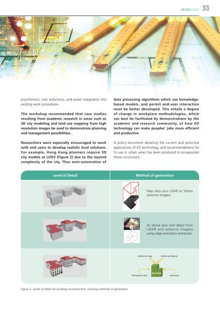
For example, <strong>Hong</strong> <strong>Kong</strong> planners require 3D<br />
city models at LOD3 (Figure 2) due to the layered<br />
complexity of the city. Thus semi-automation of<br />
data processing algorithms which use knowledgebased<br />
models, and permit end-user interaction<br />
must be better developed. This entails a degree<br />
of change in workplace methodologies, which<br />
can best be facilitated by demonstrations by the<br />
academic and research community, of how EO<br />
technology can make peoples’ jobs more efficient<br />
and productive.<br />
A policy document detailing the current and potential<br />
applications of EO technology, and recommendations for<br />
its use in urban areas has been produced to encapsulate<br />
these conclusions.<br />
Level of Detail<br />
Method of generation<br />
Map data plus LiDAR or Stereo<br />
airborne imagery<br />
As above plus roof detail from<br />
LiDAR and airborne imagery<br />
using edge and plane extraction<br />
Airborne Lidar<br />
Airborne Optical<br />
Terrestrial Laser<br />
Buildin<br />
Airborne<br />
Figure 2. Levels of detail for building reconstruction, showing methods of generation