to view - NSW Rural Fire Service
to view - NSW Rural Fire Service
to view - NSW Rural Fire Service

Create successful ePaper yourself
Turn your PDF publications into a flip-book with our unique Google optimized e-Paper software.
<strong>NSW</strong> <strong>Fire</strong> Areas<br />
<strong>NSW</strong> <strong>Fire</strong> Areas<br />
<strong>NSW</strong> <strong>Fire</strong> Areas Showing Local Government Areas<br />
<strong>NSW</strong> <strong>Fire</strong> Areas Showing Local Government Areas<br />
1. Far North Coast 1. Far North Coast 4. Greater 4. Greater Sydney Sydney Region<br />
Ballina<br />
Ballina All Sydney All Sydney Metropolitan<br />
Byron<br />
Councils Plus Gosford, Blue<br />
Byron<br />
Clarence Valley Councils Mountains, Plus Gosford, Hawkesbury Blue<br />
Clarence Valley Kyogle Mountains, and Wyong Hawkesbury<br />
Kyogle<br />
Lismore and Wyong 5. Illawarra/Shoalhaven<br />
Richmond Valley<br />
Kiama<br />
Lismore<br />
Tweed 5. Illawarra/Shoalhaven<br />
Shellharbour<br />
Richmond Valley 2. North Coast Kiama Shoalhaven<br />
Bellingen<br />
Wingecarribee<br />
Tweed<br />
Shellharbour<br />
Coffs Harbour<br />
Wollondilly<br />
2. North Coast Gloucester Shoalhaven Wollongong<br />
Bellingen Great Lakes Wingecarribee<br />
6. Far South Coast<br />
Greater Taree<br />
Bega Valley<br />
Coffs Harbour Hastings Wollondilly Eurobodalla<br />
Gloucester Kempsey Wollongong 7. Monaro/Alpine<br />
Great Lakes Nambucca 6. Far South Bombala Coast<br />
3. Greater Hunter<br />
Cooma Manaro<br />
Greater Taree Cessnock Bega Valley Snowy River<br />
Hastings Dungog Eurobodalla 8. ACT<br />
Kempsey Lake Macquarie 7. Monaro/Alpine Australian Capital<br />
Maitland<br />
Terri<strong>to</strong>ry<br />
Nambucca Muswellbrook Bombala 9. Southern Ranges<br />
3. Greater Hunter Newcastle Cooma Manaro Eastern Capital Regional<br />
Cessnock Port Stephens Snowy River City<br />
Single<strong>to</strong>n<br />
Greater Argyle<br />
Dungog<br />
Upper Hunter 8. ACT Greater Queanbeyan City<br />
Lake Macquarie<br />
Maitland<br />
Australian Upper Capital Lachlan<br />
Yass Valley<br />
Terri<strong>to</strong>ry<br />
Muswellbrook<br />
9. Southern Ranges<br />
Newcastle<br />
Eastern Capital Regional<br />
Port Stephens<br />
City<br />
Single<strong>to</strong>n<br />
Greater Argyle<br />
Upper Hunter<br />
Greater Queanbeyan City<br />
Upper Lachlan<br />
Yass Valley<br />
10. Central Ranges Ranges 14. Upper Central 14. Upper West Central West<br />
Bathurst Regional Regional Plains Plains 18. Southern Riverina<br />
Blayney<br />
Bogan<br />
Berrigan<br />
Cabonne Blayney<br />
Coonamble Bogan Conargo<br />
Cowra Cabonne<br />
Gilgandra Coonamble Corowa<br />
Lithgow CowraCity<br />
Warren Gilgandra Denilliquin<br />
Mid Western Regional 15. Lower Central West Jerilderie<br />
Oberon Lithgow City<br />
Plains Warren Murray<br />
Orange Mid Western Regional Bland 15. Lower Central Urana West<br />
Welling<strong>to</strong>n<br />
Dubbo<br />
Wakool<br />
Oberon<br />
Plains<br />
11. New England<br />
Forbes<br />
19. Northern Riverina<br />
Armidale OrangeDumaresq<br />
Lachlan Bland<br />
Carrathool<br />
Glen Welling<strong>to</strong>n Innes/Severn<br />
Narromine Dubbo Griffith<br />
Guyra<br />
Parkes<br />
Hay<br />
11. Tenterfield New England<br />
Temora Forbes Lee<strong>to</strong>n<br />
Uralla Armidale Dumaresq Weddin Lachlan Murrumbidgee<br />
Walcha Glen Innes/Severn 16. Southern Slopes Narromine Narrandera<br />
12. Northern Slopes<br />
Boorowa<br />
20. South Western<br />
Gunnedah Guyra<br />
CootamundraParkes<br />
Balranald<br />
Gwydir Tenterfield<br />
Gundagai Temora Wentworth<br />
Inverell Uralla<br />
Harden Weddin 21. Far Western<br />
Liverpool Plains<br />
Tumbarumba<br />
Bourke<br />
Tamworth WalchaRegional<br />
Tumut 16. Southern Slopes Brewarrina<br />
12. 13. Northern WesternSlopes<br />
Young Boorowa Broken Hill<br />
Moree Gunnedah Plains<br />
17. Eastern Riverina Cootamundra Central Darling<br />
Narrabri<br />
Albury City<br />
Cobar<br />
Walgett Gwydir<br />
Coolamon Gundagai Unicorporated <strong>NSW</strong><br />
Warumbungles Inverell<br />
Greater HumeHarden<br />
Junee<br />
Liverpool Plains<br />
Tumbarumba<br />
Lockhart<br />
Tamworth Regional Wagga Wagga Tumut<br />
13. North Western<br />
Moree Plains<br />
Narrabri<br />
Walgett<br />
Warumbungles<br />
Young<br />
17. Eastern Riverina<br />
Albury City<br />
Coolamon<br />
Greater Hume<br />
Junee<br />
Lockhart<br />
Wagga Wagga<br />
18. Southern Riverina<br />
Berrigan<br />
Conargo<br />
Corowa<br />
Denilliquin<br />
Jerilderie<br />
Murray<br />
Urana<br />
Wakool<br />
19. Northern Riverina<br />
Carrathool<br />
Griffith<br />
Hay<br />
Lee<strong>to</strong>n<br />
Murrumbidgee<br />
Narrandera<br />
20. South Western<br />
Balranald<br />
Wentworth<br />
21. Far Western<br />
Bourke<br />
Brewarrina<br />
Broken Hill<br />
Central Darling<br />
Cobar<br />
Unicorporated <strong>NSW</strong><br />
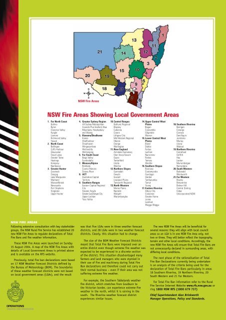
<strong>NSW</strong> FIRE AREAS<br />
Following extensive consultation with key stakeholder<br />
groups, the <strong>NSW</strong> <strong>Rural</strong> <strong>Fire</strong> <strong>Service</strong> has established 20<br />
new <strong>NSW</strong> <strong>Fire</strong> Areas <strong>to</strong> regulate declarations of Total<br />
<strong>Fire</strong> Bans and fire weather information.<br />
These <strong>NSW</strong> <strong>Fire</strong> Areas were launched on Sunday<br />
15 August 2004. A map of the <strong>NSW</strong> <strong>Fire</strong> Areas with<br />
details of Local Government Areas is printed above<br />
and is available on the RFS website.<br />
Previously, <strong>to</strong>tal fire ban declarations were based<br />
on 17 <strong>NSW</strong> Weather Forecast Districts defined by<br />
the Bureau of Meteorology (BOM). The boundaries<br />
of these weather forecast districts were not based<br />
on local government areas (LGAs), and the result<br />
was that five LGAs were in three weather forecast<br />
districts, and 28 LGAs were in two weather forecast<br />
districts. Clearly, this situation had <strong>to</strong> change.<br />
The size of the BOM Weather Forecast Districts<br />
meant that Total <strong>Fire</strong> Bans were imposed over an<br />
entire district even though extreme fire weather was<br />
expected <strong>to</strong> be experienced in a discrete section<br />
of the district. This situation disadvantaged many<br />
farmers and land managers who were stymied in<br />
their use of fire and machinery during Total <strong>Fire</strong><br />
Ban declarations and therefore could not carry out<br />
their normal business – even if their area was not<br />
suffering extreme fire weather.<br />
For example, the Southern Tablelands weather<br />
fire district, which stretches from Goulburn <strong>to</strong><br />
the Vic<strong>to</strong>rian border, can experience extreme fire<br />
weather in the north, whilst it is raining in the<br />
south. The Riverina weather forecast district<br />
experiences similar issues.<br />
The new <strong>NSW</strong> <strong>Fire</strong> Areas will be beneficial for<br />
several reasons: they will align with local council<br />
areas so an LGA is in one <strong>NSW</strong> <strong>Fire</strong> Area only, not<br />
two or three. They will better reflect the <strong>to</strong>pography,<br />
terrain and other local conditions. Accordingly, the<br />
new <strong>NSW</strong> <strong>Fire</strong> Areas will ensure that Total <strong>Fire</strong> Bans are<br />
not unnecessarily declared in surrounding areas, with<br />
differing local conditions.<br />
The next phase of the rationalisation of Total<br />
<strong>Fire</strong> Ban Declarations currently being undertaken<br />
is an analysis of the criteria being used for the<br />
declaration of Total <strong>Fire</strong> Bans particularly in areas<br />
18 Southern Riverina, 19 Northern Riverina, 20<br />
South Western and 21 Far Western.<br />
For Total <strong>Fire</strong> Ban information refer <strong>to</strong> the <strong>Rural</strong><br />
<strong>Fire</strong> <strong>Service</strong> Internet Website www.rfs.nsw.gov.au or<br />
ring 1800 <strong>NSW</strong> RFS (1800 679 737)<br />
Chief Superintendent Alan Brinkworth<br />
Manager Operations, Policy and Standards.<br />
OPERATIONS<br />
TABARDS AND BRASSARDS