Click here to view - NSW Rural Fire Service
Click here to view - NSW Rural Fire Service
Click here to view - NSW Rural Fire Service

Create successful ePaper yourself
Turn your PDF publications into a flip-book with our unique Google optimized e-Paper software.
MARSDEN ROAD<br />
151°5'0"E<br />
BEECROFT ROAD<br />
North Epping<br />
115<br />
13 13<br />
13<br />
West Pymble<br />
Gordon<br />
Killara<br />
151°10'0"E<br />
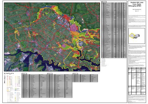
Assets<br />
Map Ref Asset name Asset type Subtype Risk level Priority Treatment<br />
13 Busaco Road Human Settlement Residential Extreme 1B (1)<br />
14 Residential, North Ryde Human Settlement Residential Extreme 1B (2)<br />
15 Lane Cove River Caravan Park Human Settlement Special <strong>Fire</strong> Extreme 1B T25;26<br />
16 Crimea Road Human Settlement Residential Extreme 1B (3)<br />
17 St T<strong>here</strong>se Primary School Human Settlement Special <strong>Fire</strong> Extreme 1B T48;51<br />
18 Ryde Hospital Human Settlement Special <strong>Fire</strong> Extreme 1B T50<br />
Hunters Hill, Lane<br />
Cove, Ryde,<br />
Willoughby BFMC<br />
Epping<br />
16<br />
48<br />
49<br />
49<br />
16<br />
130<br />
130<br />
130<br />
44<br />
44<br />
44<br />
129<br />
Macquarie Park<br />
25<br />
RYDE ROAD<br />
RYDE ROAD<br />
19 Telstra Sub Station Economic Infrastructure Extreme 1B T88<br />
20 Montisouri PreSchool Human Settlement Special <strong>Fire</strong> Extreme 1B T48;51<br />
21 De Burghs Cottage Human Settlement Residential Extreme 1B T22;23;24<br />
22 Energy Australia compound Economic Infrastructure Extreme 1B T75<br />
25 Electricity Transmission Lines Economic Infrastructure Extreme 1B (4)<br />
44 M2 Offices & Toll booths Economic Infrastructure Very High 2A T138<br />
46 River Avenue Human Settlement Residential Very High 2A (5)<br />
RYDE - Map Display Area<br />
Map 1 of 4<br />
BEECROFT ROAD<br />
CARLINGFORD ROAD<br />
49<br />
50<br />
49<br />
49<br />
BALACLAVA ROAD<br />
EPPING ROAD<br />
Marsfield<br />
59<br />
M2 MOTORWAY<br />
14<br />
M2 MOTORWAY<br />
75<br />
82<br />
21<br />
110<br />
64<br />
West Killara<br />
91<br />
West Lindfield<br />
PACIFIC HIGHWAY<br />
Lindfield<br />
PACIFIC HIGHWAY<br />
47 Riverside Corporate Park Economic Commercial Very High 2A T26;68<br />
48 Pembroke Power Sub Station Economic Infrastructure Very High 2A T48;85<br />
49 Terrys Creek Human Settlement Residential Very High 2A T48;85;51<br />
50 CSIRO Radiophysics Labora<strong>to</strong>ry Human Settlement Other Very High 2A T48;85;51<br />
51 Kittys Creek Human Settlement Residential Very High 2A (6)<br />
52 New Horizons Economic Commercial Very High 2A T67<br />
53 Field of Mars Human Settlement Residential Very High 2A T75;48;51<br />
54 Bar<strong>to</strong>n Reserve Human Settlement Residential Very High 2A T48;84;51<br />
55 Mallee Reserve Human Settlement Residential Very High 2A T48;86;51<br />
56 Denis<strong>to</strong>ne Park Human Settlement Residential Very High 2A T48;87;51<br />
This Bush <strong>Fire</strong> Risk Management Plan (BFRMP) has been prepared by the Hunters<br />
Hill, Lane Cove, Ryde, Willoughby Bush <strong>Fire</strong> Management Committee (BFMC)<br />
pursuant <strong>to</strong> section 52 of the <strong>Rural</strong> <strong>Fire</strong>s Act 1997.<br />
The aim of this BFRMP is <strong>to</strong> reduce the adverse impact of bush fires on life, property<br />
and the environment.<br />
The objectives of this BFRMP are <strong>to</strong>:<br />
- reduce the number of human-induced bush fire ignitions that cause damage <strong>to</strong> life,<br />
property or the environment;<br />
- manage fuel <strong>to</strong> reduce the spread and intensity of bush fires while minimising<br />
environmental/ecological impacts;<br />
- reduce the community's vulnerability <strong>to</strong> bush fires by improving its preparedness; and<br />
- effectively contain fires with a potential <strong>to</strong> cause damage <strong>to</strong> life, property and the<br />
environment.<br />
134<br />
57 Darvall Park Human Settlement Residential Very High 2A T48;88;51<br />
33°50'0"S<br />
VICTORIA ROAD<br />
MARSDEN ROAD<br />
STEWART STREET<br />
STEWART STREET<br />
58<br />
RUTLEDGE STREET<br />
VICTORIA ROAD<br />
Melrose Park<br />
Meadowbank<br />
Rhodes<br />
HOMEBUSH BAY DRIVE<br />
HOMEBUSH BAY DRIVE<br />
FIRST AVENUE<br />
CONCORD ROAD<br />
CONCORD ROAD<br />
BLAXLAND ROAD<br />
81<br />
87<br />
135<br />
58<br />
46<br />
57<br />
61<br />
47<br />
46<br />
18<br />
133<br />
58<br />
57<br />
46<br />
58<br />
57<br />
North Ryde<br />
56<br />
Denis<strong>to</strong>ne East<br />
46<br />
58<br />
19<br />
56<br />
47<br />
114<br />
58<br />
56<br />
17<br />
46<br />
58<br />
57<br />
56 56<br />
60<br />
46<br />
Denis<strong>to</strong>ne<br />
56<br />
90<br />
RYDE<br />
58<br />
56<br />
Denis<strong>to</strong>ne West 57<br />
78<br />
57<br />
78<br />
98<br />
78 78<br />
11<br />
77<br />
78 78<br />
29 104<br />
70<br />
107<br />
119<br />
51<br />
126<br />
51<br />
51<br />
104 101<br />
20<br />
104 102<br />
52<br />
51<br />
51<br />
104<br />
131<br />
51<br />
51<br />
51<br />
69<br />
51<br />
69<br />
West Ryde<br />
51<br />
51<br />
51<br />
51<br />
128<br />
54<br />
51<br />
121<br />
54<br />
51<br />
1<br />
54<br />
51 51<br />
99<br />
121<br />
54<br />
27<br />
Erming<strong>to</strong>n<br />
53<br />
104<br />
54<br />
Ryde<br />
East Ryde<br />
28<br />
151°5'0"E<br />
0 0.25 0.5 0.75 1<br />
km<br />
134<br />
45<br />
58 Brush Farm Park Human Settlement Residential Very High 2A T48;89;51<br />
59 Ivanhoe Housing Commision Human Settlement Residential Very High 2A T92;51<br />
106<br />
83<br />
Eastwood<br />
134<br />
60 Blenheim Park Human Settlement Residential Very High 2A T48;90;51<br />
84<br />
85<br />
61 Bundara Reserve Human Settlement Residential Very High 2A T48;91;51<br />
15<br />
134<br />
76<br />
134<br />
86<br />
62 Koonjeree Picnic Area Economic Tourist and Very High 2A T2<br />
CONCORD ROAD<br />
CHURCH STREET<br />
CHURCH STREET<br />
DEVLIN STREET<br />
Parramatta River<br />
DEVLIN STREET<br />
BLAXLAND ROAD<br />
GOULDING ROAD<br />
79<br />
99<br />
53<br />
54<br />
99<br />
143 Lane Cove West<br />
108 108<br />
104 100<br />
113<br />
22<br />
108 100<br />
80 53<br />
141<br />
53<br />
53<br />
100 100<br />
53<br />
122<br />
53<br />
104<br />
124<br />
LANE COVE<br />
55<br />
55<br />
55<br />
Boronia Park<br />
67<br />
92<br />
Gladesville<br />
138<br />
120<br />
Lane Cove<br />
66<br />
River<strong>view</strong><br />
127<br />
Linley Point<br />
Putney<br />
Longueville<br />
Tennyson<br />
Tennyson Point<br />
Concord West<br />
Treatments<br />
Treatments<br />
TWIN ROAD<br />
LANE COVE ROAD<br />
LANE COVE ROAD<br />
WICKS ROAD<br />
MONASH ROAD<br />
PITTWATER ROAD<br />
RYDE ROAD<br />
DELHI ROAD<br />
BURNS BAY ROAD<br />
GLADESVILLE ROAD<br />
88<br />
111<br />
RIVERSIDE DRIVE<br />
136 65 65<br />
65<br />
89 112 65<br />
65<br />
62<br />
46<br />
PENROSE STREET<br />
DELHI ROAD<br />
123<br />
104 120<br />
120<br />
EPPING ROAD<br />
CENTENNIAL AVENUE<br />
BRIDGE STREET<br />
104 123<br />
123<br />
MILLWOOD AVENUE<br />
7<br />
39<br />
105<br />
41 Chatswood West<br />
WILLOUGHBY 40<br />
40<br />
8<br />
Lane Cove North<br />
HUNTERS HILL<br />
(5):T69;70;63;48;51<br />
33°50'0"S<br />
140<br />
Hunters Hill<br />
(6):T67;71;48;51<br />
132<br />
116<br />
(7):T105;57;48;51<br />
132<br />
(8):T101;102;103<br />
132 132<br />
TarbanHuntleys Cove<br />
(9):T48;75;51;116;10;57;53<br />
Homebush Bay<br />
142<br />
117<br />
(10):T22;24;23;120;121<br />
Huntleys Point<br />
Mortlake<br />
Liberty Grove<br />
139<br />
137<br />
Woolwich<br />
Henley<br />
Breakfast Point<br />
Treatments<br />
ID Treatment strategy Action Agencies (Support)<br />
ID Treatment strategy Action Agencies (Support)<br />
ID Treatment strategy Action Agencies (Support)<br />
T115 Hazard Reduction SFAZ - DECC<br />
T10 Hazard Reduction APZ - Lake at SC Johnson Private<br />
T2 Hazard Reduction SFAZ - Delhi Road entrance DECC<br />
Sugarloaf Point<br />
T116 Hazard Reduction SFAZ - Epping Rd Plateau LGA (<strong>NSW</strong>FB)<br />
T13 Hazard Reduction SFAZ - Avian Crescent LGA (<strong>NSW</strong>FB)<br />
T63 Hazard Reduction SFAZ - River Avenue DECC<br />
T119 Hazard Reduction SFAZ - Terrys Creek DECC (DL, LGA, T16 Hazard Reduction SFAZ - Berriwerri Reserve DECC (DL, LGA, <strong>NSW</strong>FB)<br />
T67 Hazard Reduction LMZ - Portious Park LGA (<strong>NSW</strong>FB)<br />
<strong>NSW</strong>FB)<br />
T120 Hazard Reduction SFAZ - Bloodwoods DECC (<strong>NSW</strong>FB)<br />
T17 Hazard Reduction SFAZ - Woodvale Ave DECC (DL, LGA, DECC, <strong>NSW</strong>FB) T68 Hazard Reduction SFAZ - Delhi Road A DECC (<strong>NSW</strong>FB)<br />
B<br />
T121 Hazard Reduction SFAZ - Riverside Drive <strong>NSW</strong>FB (<strong>NSW</strong>FB)<br />
T18 Hazard Reduction SFAZ - Busaco Road DECC<br />
T69 Hazard Reduction SFAZ - Koboda Rocks DECC<br />
VES<br />
T125 Hazard Reduction LMZ - Burrows Park LGA (<strong>NSW</strong>FB)<br />
T19 Hazard Reduction SFAZ - Durham Reserve DECC (DL, LGA, DECC, <strong>NSW</strong>FB) T70 Hazard Reduction SFAZ - Quebec Road LGA, <strong>NSW</strong>FB (DL, DECC)<br />
T133 Hazard Reduction LMZ - Glades Bay LGA (<strong>NSW</strong>FB)<br />
T20 Hazard Reduction SFAZ - Tuckwell Place A DECC (DL, LGA, <strong>NSW</strong>FB)<br />
T71 Hazard Reduction SFAZ - Wallumatta Nature Reserve DECC<br />
T134 Hazard Reduction LMZ - ELS Hall LGA (<strong>NSW</strong>FB)<br />
T21 Hazard Reduction SFAZ - Tuckwell Place B DECC (DL, LGA, <strong>NSW</strong>FB)<br />
T84 Hazard Reduction LMZ - Bar<strong>to</strong>n Reserve LGA (<strong>NSW</strong>FB)<br />
T22 Hazard Reduction SFAZ - Riverside Drive entry DECC (<strong>NSW</strong>FB)<br />
T85 Hazard Reduction LMZ - Terrys Creek LGA (<strong>NSW</strong>FB)<br />
T86 Hazard Reduction LMZ - Mallee LGA (<strong>NSW</strong>FB)<br />
T23 Hazard Reduction SFAZ - Blue Hole DECC (<strong>NSW</strong>FB)<br />
T87 Hazard Reduction LMZ - Denis<strong>to</strong>ne LGA (<strong>NSW</strong>FB)<br />
T24 Hazard Reduction SFAZ - Bloodwoods A DECC (<strong>NSW</strong>FB)<br />
Park<br />
T89 Hazard Reduction LMZ - Brush Farm Park LGA (<strong>NSW</strong>FB)<br />
T25 Hazard Reduction SFAZ - Scribbly Gums DECC (<strong>NSW</strong>FB)<br />
T90 Hazard Reduction LMZ - Blenheim Park LGA (<strong>NSW</strong>FB)<br />
T26 Hazard Reduction SFAZ - Carters Creek A DECC (<strong>NSW</strong>FB)<br />
T91 Hazard Reduction LMZ - Bundara Reserve LGA (<strong>NSW</strong>FB)<br />
T32 Hazard Reduction APZ - Busaco Road DECC (LGA)<br />
T92 Hazard Reduction LMZ - Ivanhoe DL, LGA (<strong>NSW</strong>FB)<br />
T44 Hazard Reduction SFAZ - Mooney street LGA<br />
T99 Hazard Reduction SFAZ - Tunks Hill DECC (<strong>NSW</strong>FB)<br />
T48 Preparedness APZ - Annual maintenance roster LGA, Private<br />
T138 Hazard Reduction APZ - create and Private (RTA)<br />
T49 Hazard Reduction LMZ - Crimea Road LGA (<strong>NSW</strong>FB)<br />
maintain<br />
T1 Hazard Reduction SFAZ - Delhi Road C DECC<br />
T50 Hazard Reduction LMZ - Ryde Hospital DL (<strong>NSW</strong>FB)<br />
T97 Hazard Reduction APZ - Mown area DECC<br />
T51 Community Education Letterdrop <strong>to</strong> residents LGA<br />
T98 Hazard Reduction APZ - Tunks Hill DECC<br />
T53 Hazard Reduction APZ - Old Pacific Power Site LGA, Private<br />
T100 Hazard Reduction SFAZ - Commandment DECC T54 Hazard Reduction APZ - Blackman Park LGA<br />
Rock (<strong>NSW</strong>FB)<br />
T101 Hazard Reduction SFAZ - Delhi Road B DECC (<strong>NSW</strong>FB)<br />
T55 Hazard Reduction APZ - 35 Sirius Rd Lane Cove West Private, Energy Australia (LGA,<br />
T102 Hazard Reduction SFAZ - Ironbark Corner DECC<br />
T56 Hazard Reduction LMZ - Ventemans Reach LGA<br />
T103 Hazard Reduction SFAZ - Ironbark Corner DECC<br />
T57 Hazard Reduction SFAZ - Magdala Road DECC<br />
T104 Hazard Reduction SFAZ - Moola/Illoura/Koonjeree DECC<br />
T75 Hazard Reduction LMZ - Field of Mars LGA (<strong>NSW</strong>FB)<br />
picnic areas<br />
T105 Hazard Reduction SFAZ - Nundah reserve DECC<br />
T88 Hazard Reduction LMZ - Darvall Park LGA (<strong>NSW</strong>FB)<br />
123<br />
151°10'0"E<br />
MOWBRAY ROAD<br />
104<br />
118<br />
RIVER ROAD<br />
64 Porters Creek Bridge Cultural Non Very High 2A T99<br />
75 Edan Garden Retail Centre Economic Commercial High 3A T97;98;99<br />
76 Northern Suburbs Cemetery Cultural Non High 3A T99<br />
77 North Ryde RSL Club Economic Commercial High 3A T48;51<br />
78 Banool, Nundar Reserves Human Settlement Residential High 3A (7)<br />
79 Field of Mars Cemetery Cultural Non High 3A T75;48;51<br />
80 Field of Mars Environmental Human Special High 3A T48;75;51<br />
Education Settlement <strong>Fire</strong><br />
81 Brush Farm Park Sports Facilities Economic Tourist and High 3A T48;89;51<br />
82 Tunks Hill Picnic Area Economic Tourist and High 3A T98;99<br />
83 Halfway Point Picnic Area Economic Tourist and High 3A T25;100<br />
84 Scribbly Gums Picnic Area Economic Tourist and High 3A T25;100<br />
85 Commandment Rock Picnic Area Economic Tourist and High 3A T100<br />
86 Cot<strong>to</strong>nwood Glen Picnic Area Economic Tourist and High 3A T100<br />
87 Carters Creek Picnic Area Economic Tourist and High 3A (8)<br />
88 Moola Picnic Area Economic Tourist and High 3A T104<br />
89 Illoura and Blue Wren Picnic Area Economic Tourist and High 3A T104;1<br />
95 Ecological Community Environment Endangered High 3A T44;13<br />
96 Flora Environment Vulnerable High 3A T99<br />
131 East Ryde Public School Human Settlement Special <strong>Fire</strong> High 3C T51<br />
107 Magdala Park Economic Tourist and Medium 4 T48<br />
108 Burrows Park Human Settlement Residential Medium 4 T48;125;51<br />
109 Field of Mars Information Centre Human Settlement Special <strong>Fire</strong> Medium 4 (9)<br />
110 De Burghs entrance box Economic Tourist and Medium 4 (10)<br />
111 Lane Cove Boatshed Economic Tourist and Medium 4 T104<br />
113 Sugarloaf Carpark Economic Tourist and Medium 4 T75<br />
114 Sydney Water compound River Ave Economic Infrastructure Medium 4 T63<br />
115 Browns Waterhole picnic area Economic Tourist and Medium 4 T16;119<br />
129 Christie Park Economic Tourist and Low NA T48;51<br />
130 Macquarie University Sports Centre Economic Tourist and Low NA T48<br />
132 Glades Bay Human Settlement Residential Low NA T48;133;51<br />
133 Brush Park Economic Commercial Low NA T48;89;51<br />
Bowling Club<br />
134 ELS Hall Park Human Settlement Residential Low NA T48;134;51<br />
135 11 River Ave Human Settlement Residential Low NA T63<br />
141 Sugarloaf Point Economic Tourist and Low NA T115<br />
picnic area<br />
(1):T18;32;48;51<br />
(2):T19;20;21;48;51<br />
(3):T16;17;48;49;51<br />
(4):T55;53;54;56;57<br />
This map forms part of the BFRMP for the Hunters Hill, Lane Cove, Ryde, Willoughby<br />
BFMC, covering the local government area(s) of . It should be <strong>view</strong>ed in conjunction<br />
with the accompanying BFRMP document which provides further details on the BFMC<br />
area, the assets assessed and the risk assessment process used.<br />
1<br />
4<br />
3<br />
2<br />
Re<strong>view</strong><br />
Under the <strong>Rural</strong> <strong>Fire</strong>s Act 1997 this plan must be re<strong>view</strong>ed and updated within each<br />
successive five year period following the constitution of the BFMC. The Hunters Hill,<br />
Lane Cove, Ryde, Willoughby BFMC will also re<strong>view</strong> this plan as necessary. This may<br />
be triggered by a range of circumstances, including but not limited <strong>to</strong>:<br />
- changes <strong>to</strong> the BFMC area, organisational reponsibilities or legislation;<br />
- changes <strong>to</strong> the bush fire risk in the area; or<br />
- following a major fire event.<br />
Assets<br />
This BFRMP identifies the assets that are considered by the Hunters Hill, Lane Cove,<br />
Ryde, Willoughby BFMC and community <strong>to</strong> be at risk from bush fires, assesses the<br />
bush fire risk <strong>to</strong> each asset and assigns treatments designed <strong>to</strong> mitigate the risk.<br />
Assets in the BFMC area identified as requiring treatments are listed in the assets<br />
table. Other assets within the BFMC area that were assessed as not requiring<br />
treatments within the life of this plan are listed in the appendix <strong>to</strong> the BFRMP<br />
document. The Map Ref number "NA" denotes non-spatial assets.<br />
Treatments<br />
Specific treatments assigned <strong>to</strong> assets in the Hunters Hill, Lane Cove, Ryde,<br />
Willoughby area are listed in the treatments table and linked <strong>to</strong> the assets which they<br />
are designed <strong>to</strong> protect. Standard BFMC wide treatments (i.e. not linked <strong>to</strong> a specific<br />
asset) which occur on an ongoing basis within the BFMC area are:<br />
- re<strong>view</strong>ing the bush fire prone land map;<br />
- ensuring developments in the bush fire prone land comply with Planning for Bush<br />
<strong>Fire</strong> Protection;<br />
- using the Local Environment Plan/s (LEPs) <strong>to</strong> control development in areas with a<br />
bush fire risk;<br />
- varying the standard bush fire danger period as required;<br />
- requiring permits during bush fire danger periods<br />
- prosecution of arsonists/offenders<br />
- investigation of bush fire cause;<br />
- normal fire suppression activities;<br />
- assessing and managing compliance with strategic fire-fighting resource allocation<br />
management systems;<br />
- preparation of a S52 Operations Coordination Plan;<br />
Note on LMZ: All areas not specifically mapped as an APZ, SFAZ or FEZ are<br />
considered as LMZ for this risk management plan. For areas identified by an LMZ<br />
polygon on the map, please refer <strong>to</strong> the BFRMP document for the specific land<br />
management objectives.<br />
Zone Purpose Suppression Zone<br />
Asset To protect human life, To enable the safe As per RFS<br />
Protection property and highly use of Direct Attack document Standards<br />
Zone valued public assets supression strategies for Asset Protection<br />
and values.<br />
within the zone. Zones.<br />
To minimise bush fire<br />
impacts on<br />
undefended assets.<br />
Strategic To provide strategic To improve the Zone width related <strong>to</strong><br />
<strong>Fire</strong><br />
areas of fire<br />
likelihood and safe suppression<br />
Advantage protection advantage use of:<br />
objectives and<br />
Zone which will reduce the Parallel Attack dependant upon:<br />
speed and intensity of suppression<br />
- Topography<br />
bush fires, and strategies within the - Aspect<br />
reduce the potential zone.<br />
- Spotting propensity<br />
for spot fire<br />
and/or<br />
- Location of<br />
development. Indirect Attack (back adjacent fire breaks<br />
To aid containment of burning) in high <strong>to</strong> - Mosaic pattern of<br />
wildfires <strong>to</strong> existing very high fire weather treatment<br />
management conditions within the Assess Overall Fuel<br />
boudnaries.<br />
zone.<br />
Hazard (OFH) once<br />
vegetation<br />
To reduce the communities reach<br />
likelihood of:<br />
minimum fire<br />
Crown fire<br />
thresholds within this<br />
development within plan.<br />
the zone.<br />
Management<br />
and/or<br />
practices should aim<br />
Spot fire ignition <strong>to</strong> achieve mosaic<br />
potential from the fuel reduction<br />
zone.<br />
patterns so that the<br />
majority of the SFAZ<br />
has an OFH of less<br />
than high..<br />
Land To meet relevant land As per the land As appropriate <strong>to</strong><br />
Management management management and fire achieve land<br />
Zone objectives in area protection objectives management, e.g.<br />
w<strong>here</strong> APZs or of the responsible heritage and/or fire<br />
SFAZs are not land management protection e.g. broad<br />
appropriate.<br />
agency.<br />
scale mosaic burning<br />
To reduce the objectives.<br />
likelihood of spread of<br />
fires.<br />
To undertake mosaic<br />
burning.<br />
<strong>Fire</strong><br />
To exclude bush fires. N/A Variable dependant<br />
Exclusion<br />
on size of fire<br />
Zone<br />
sensitive area<br />
requiring protection.<br />
Disclaimer<br />
The Hunters Hill, Lane Cove, Ryde, Willoughby BFMC makes every effort <strong>to</strong> ensure the<br />
quality of the information available on this map. Before relying on the information on<br />
this map, users should carefully evaluate its accuracy, completeness and relevance for<br />
their purposes, and should obtain any appropriate professional advice relevant <strong>to</strong> their<br />
particular circumstances.<br />
The Hunters Hill, Lane Cove, Ryde, Willoughby BFMC can not guarantee and assumes<br />
no legal liability or responsibility for the accuracy, currency or completeness of the<br />
information. Copyright: Hunters Hill, Lane Cove, Ryde, Willoughby BFMC 2010.<br />
Authorized by .......................................................... of Hunters Hill, Lane Cove, Ryde,<br />
Willoughby BFMC.<br />
Date created: Monday, 1 March 2010<br />
BFRR version 2.0.1.5