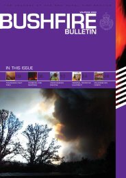
Click here to view - NSW Rural Fire Service
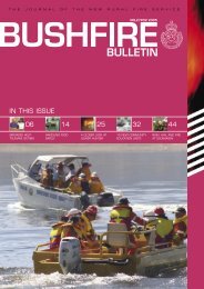
Click here to view - NSW Rural Fire Service
Click here to view - NSW Rural Fire Service

You also want an ePaper? Increase the reach of your titles
YUMPU automatically turns print PDFs into web optimized ePapers that Google loves.
25<br />
60<br />
M2 MOTORWAY<br />
78<br />
M2 MOTORWAY<br />
46<br />
47 46<br />
90<br />
114<br />
41<br />
151°10'0"E<br />
105 Chatswood West<br />
40<br />
HIGH STREET<br />
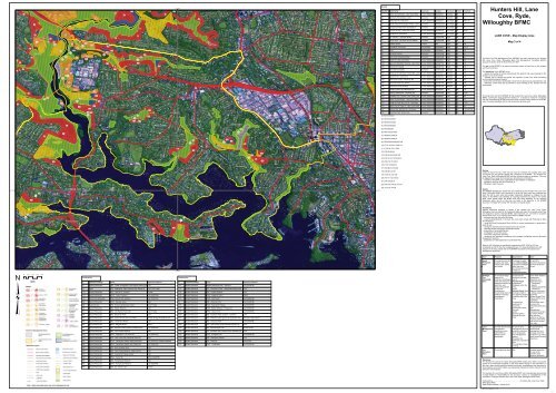
Assets<br />
Map Ref Asset name Asset type Subtype Risk level Priority Treatment<br />
1 Moore St (northside) Human Settlement Residential Extreme 1B (1)<br />
- Lane Cove West<br />
25 Electricity Transmission Lines Economic Infrastructure Extreme 1B (2)<br />
26 Valley<strong>view</strong> Rd, Greenwich Human Settlement Residential Very High 2A T60;4;15<br />
27 Telstra Telecommunication Economic Infrastructure Very High 2A (3)<br />
Tower - Lane<br />
Hunters Hill, Lane<br />
Cove, Ryde,<br />
Willoughby BFMC<br />
28 Energy Australia Power Sub Station Economic Infrastructure Very High 2A (4)<br />
51<br />
51<br />
PITTWATER ROAD<br />
78<br />
78<br />
77<br />
51<br />
RYDE<br />
51<br />
78<br />
78 78<br />
107<br />
98<br />
104<br />
29<br />
70<br />
101<br />
104<br />
69<br />
104<br />
69<br />
128<br />
119<br />
126<br />
102<br />
104<br />
121<br />
11<br />
8<br />
120<br />
104<br />
120<br />
Lane Cove North<br />
WILLOUGHBY<br />
PENSHURST STREET<br />
MOWBRAY ROAD<br />
Willoughby<br />
ALPHA ROAD<br />
29 Possum Corner - child care centre Human Settlement Special <strong>Fire</strong> Very High 2A T9;93<br />
30 Standish St, Greenwich Human Settlement Residential Very High 2A (5)<br />
69 SC Johnson - chemical fac<strong>to</strong>ry Economic Commercial High 3A (6)<br />
70 Office Block - adj Shell <strong>Service</strong> Station Economic Commercial High 3A (7)<br />
91 Fiddens Wharf Cultural Non High 3A T99<br />
95 Ecological Community Environment Endangered High 3A T44;13<br />
96 Flora Environment Vulnerable High 3A T99<br />
98 Penfords Fac<strong>to</strong>ry Economic Commercial High 3A (8)<br />
99 Lane Cove Industrial Estate Economic Commercial High 3B (9)<br />
100 Wood St, Lane Cove West Human Settlement Residential High 3C (10)<br />
122 Aged and Disability Housing Human Settlement Special <strong>Fire</strong> High 3C (11)<br />
- Lane Cove<br />
LANE COVE - Map Display Area<br />
Map 3 of 4<br />
This Bush <strong>Fire</strong> Risk Management Plan (BFRMP) has been prepared by the Hunters<br />
Hill, Lane Cove, Ryde, Willoughby Bush <strong>Fire</strong> Management Committee (BFMC)<br />
pursuant <strong>to</strong> section 52 of the <strong>Rural</strong> <strong>Fire</strong>s Act 1997.<br />
51<br />
51<br />
East Ryde<br />
99<br />
27<br />
104<br />
28<br />
99<br />
1<br />
121<br />
EPPING ROAD<br />
EPPING ROAD<br />
CENTENNIAL AVENUE<br />
120<br />
LONGUEVILLE ROAD<br />
LONGUEVILLE ROAD<br />
GORE HILL FREEWAY<br />
Artarmon<br />
125 Greenwich Hospital Human Settlement Special <strong>Fire</strong> High 3C (12)<br />
101 Shell <strong>Service</strong> Station Economic Commercial Medium 4 (13)<br />
102 Mowbray Rd, Merinda, Human Settlement Residential Medium 4 (14)<br />
Pinaroo Rd - Lane<br />
103 Obsorne Rd - Lane Cove Human Settlement Residential Medium 4 (15)<br />
126 Child Care Centre - Mowbray Rd Human Settlement Special <strong>Fire</strong> Medium 4 (16)<br />
128 Orion Rd Child Care Centre Human Settlement Special <strong>Fire</strong> Medium 4 (17)<br />
144 Greenwich Public School Human Settlement Special <strong>Fire</strong> Medium 4 (18)<br />
The aim of this BFRMP is <strong>to</strong> reduce the adverse impact of bush fires on life, property<br />
and the environment.<br />
The objectives of this BFRMP are <strong>to</strong>:<br />
- reduce the number of human-induced bush fire ignitions that cause damage <strong>to</strong> life,<br />
property or the environment;<br />
- manage fuel <strong>to</strong> reduce the spread and intensity of bush fires while minimising<br />
environmental/ecological impacts;<br />
- reduce the community's vulnerability <strong>to</strong> bush fires by improving its preparedness; and<br />
- effectively contain fires with a potential <strong>to</strong> cause damage <strong>to</strong> life, property and the<br />
environment.<br />
FLAT ROCK DRIVE<br />
53<br />
53<br />
22<br />
113<br />
Boronia Park<br />
92<br />
141<br />
66<br />
67<br />
99<br />
104<br />
100<br />
143<br />
100<br />
100<br />
100<br />
122<br />
124 104<br />
Lane Cove West<br />
PENROSE STREET<br />
BRIDGE STREET<br />
123<br />
104<br />
123<br />
123 123<br />
LANE COVE<br />
Lane Cove<br />
Osborne Park<br />
104<br />
GORE HILL FREEWAY<br />
PACIFIC HIGHWAY<br />
Gore Hill<br />
St Leonards<br />
CHANDOS STREET<br />
WILLOUGHBY ROAD<br />
WARRINGAH FREEWAY<br />
Naremburn<br />
WARRINGAH FREEWAY<br />
BROOK STREET<br />
118 William Edward St & Borambil Rd - Human Settlement Residential Low NA (19)<br />
119 Fac<strong>to</strong>ry Warehouse - Mowbray Rd Economic Commercial Low NA T9;93<br />
120 Elizabeth Pde, Gordon Cres, Kullah Human Settlement Residential Low NA (20)<br />
Pde -<br />
121 Moore St (southside) - Lane Cove West Human Settlement Residential Low NA (21)<br />
123 Bridge St, River Rd, Fox St - River<strong>view</strong> Human Settlement Residential Low NA T15;6<br />
124 Myee Cres <strong>to</strong> Cope St - Lane Cove West Human Settlement Residential Low NA (22)<br />
127 Kallaroo Rd, Werona Rd - River<strong>view</strong> Human Settlement Residential Low NA T15;135;136<br />
143 Blackman Park Tennis Club Economic Tourist and Low NA (23)<br />
(1):T9;10;15;52;8<br />
(2):T55;53;54;56;57<br />
(3):T65;55;53;54;56<br />
(4):T64;55;59;56;53<br />
(5):T60;58;82;83<br />
(6):T96;10;53;57;48;9<br />
(7):T95;94;57;48;9;53<br />
This map forms part of the BFRMP for the Hunters Hill, Lane Cove, Ryde, Willoughby<br />
BFMC, covering the local government area(s) of . It should be <strong>view</strong>ed in conjunction<br />
with the accompanying BFRMP document which provides further details on the BFMC<br />
area, the assets assessed and the risk assessment process used.<br />
1<br />
4<br />
CHRISTIE STREET<br />
River<strong>view</strong><br />
104<br />
RIVER ROAD<br />
104<br />
103<br />
26<br />
(8):T95;94;57;48;9;53<br />
(9):T64;53;65;55;59;56;57;48<br />
(10):T112;113;54;114;56;115<br />
2<br />
3<br />
NORTHWOOD ROAD<br />
Linley Point<br />
127<br />
118<br />
104<br />
144<br />
(11):T131;54;113;114;56<br />
(12):T82;83;58;48<br />
(13):T95;94;53;57;48;10;9<br />
138<br />
30<br />
RIVER ROAD<br />
125<br />
(14):T9;116;10;117;93;52;8<br />
(15):T60;118;15;126;5<br />
33°50'0"S<br />
116<br />
140<br />
RYDE ROAD<br />
GLADESVILLE ROAD<br />
BURNS BAY ROAD<br />
HUNTERS HILL<br />
Hunters Hill<br />
Longueville<br />
Northwood<br />
Greenwich<br />
Wolls<strong>to</strong>necraft<br />
SHIRLEY ROAD<br />
FALCON STREET<br />
Crows Nest<br />
(16):T116;10;93;52;9<br />
(17):T53;96;10;57;48;9<br />
(18):T83;60;127;58<br />
(19):T128;15;135;136<br />
(20):T9;117;132;130;52<br />
(21):T9;10;52;8;15<br />
(22):T54;129;114;56;115;137<br />
(23):T112;54;114;56<br />
33°50'0"S<br />
Re<strong>view</strong><br />
Under the <strong>Rural</strong> <strong>Fire</strong>s Act 1997 this plan must be re<strong>view</strong>ed and updated within each<br />
successive five year period following the constitution of the BFMC. The Hunters Hill,<br />
Lane Cove, Ryde, Willoughby BFMC will also re<strong>view</strong> this plan as necessary. This may<br />
be triggered by a range of circumstances, including but not limited <strong>to</strong>:<br />
- changes <strong>to</strong> the BFMC area, organisational reponsibilities or legislation;<br />
- changes <strong>to</strong> the bush fire risk in the area; or<br />
- following a major fire event.<br />
Assets<br />
This BFRMP identifies the assets that are considered by the Hunters Hill, Lane Cove,<br />
Ryde, Willoughby BFMC and community <strong>to</strong> be at risk from bush fires, assesses the<br />
bush fire risk <strong>to</strong> each asset and assigns treatments designed <strong>to</strong> mitigate the risk.<br />
Assets in the BFMC area identified as requiring treatments are listed in the assets<br />
table. Other assets within the BFMC area that were assessed as not requiring<br />
treatments within the life of this plan are listed in the appendix <strong>to</strong> the BFRMP<br />
document. The Map Ref number "NA" denotes non-spatial assets.<br />
142<br />
TarbanHuntleys Cove<br />
Henley<br />
Huntleys Point<br />
139<br />
137<br />
117<br />
Woolwich<br />
Waver<strong>to</strong>n<br />
Treatments<br />
Specific treatments assigned <strong>to</strong> assets in the Hunters Hill, Lane Cove, Ryde,<br />
Willoughby area are listed in the treatments table and linked <strong>to</strong> the assets which they<br />
are designed <strong>to</strong> protect. Standard BFMC wide treatments (i.e. not linked <strong>to</strong> a specific<br />
asset) which occur on an ongoing basis within the BFMC area are:<br />
- re<strong>view</strong>ing the bush fire prone land map;<br />
- ensuring developments in the bush fire prone land comply with Planning for Bush<br />
<strong>Fire</strong> Protection;<br />
- using the Local Environment Plan/s (LEPs) <strong>to</strong> control development in areas with a<br />
bush fire risk;<br />
- varying the standard bush fire danger period as required;<br />
- requiring permits during bush fire danger periods<br />
- prosecution of arsonists/offenders<br />
- investigation of bush fire cause;<br />
- normal fire suppression activities;<br />
- assessing and managing compliance with strategic fire-fighting resource allocation<br />
management systems;<br />
- preparation of a S52 Operations Coordination Plan;<br />
VICTORIA ROAD<br />
Mcmahons Point<br />
Note on LMZ: All areas not specifically mapped as an APZ, SFAZ or FEZ are<br />
considered as LMZ for this risk management plan. For areas identified by an LMZ<br />
polygon on the map, please refer <strong>to</strong> the BFRMP document for the specific land<br />
management objectives.<br />
Zone Purpose Suppression Zone<br />
VICTORIA ROAD<br />
151°10'0"E<br />
Cocka<strong>to</strong>o Island<br />
Asset<br />
Protection<br />
Zone<br />
To protect human life,<br />
property and highly<br />
valued public assets<br />
and values.<br />
To enable the safe<br />
use of Direct Attack<br />
supression strategies<br />
within the zone.<br />
To minimise bush fire<br />
impacts on<br />
undefended assets.<br />
As per RFS<br />
document Standards<br />
for Asset Protection<br />
Zones.<br />
0 0.1 0.2 0.3 0.4<br />
km<br />
Treatments<br />
ID Treatment strategy Action Agencies (Support)<br />
T8 Hazard Reduction LMZ - LGA<br />
Lower Stringybark Creek (below Epping Rd)<br />
T9 Other APZ - Epping Rd, Sam Johnson Way, Moore St LGA, RTA (LGA)<br />
T10 Hazard Reduction APZ - Lake at SC Johnson Private<br />
T13 Hazard Reduction SFAZ - Avian Crescent LGA (<strong>NSW</strong>FB)<br />
T15 Community Education Direct contact with residents LGA (<strong>NSW</strong>FB)<br />
T44 Hazard Reduction SFAZ - Mooney street LGA<br />
T48 Preparedness APZ - Annual maintenance roster LGA, Private<br />
T52 Hazard Reduction LMZ - Batten Reserve LGA<br />
T53 Hazard Reduction APZ - Old Pacific Power Site LGA, Private<br />
T54 Hazard Reduction APZ - Blackman Park LGA<br />
T55 Hazard Reduction APZ - 35 Sirius Rd Lane Cove West Private, Energy Australia (LGA,<br />
T56 Hazard Reduction LMZ - Ventemans Reach LGA<br />
T57 Hazard Reduction SFAZ - Magdala Road DECC<br />
Treatments<br />
ID Treatment strategy Action Agencies (Support)<br />
T112 Hazard Reduction Hazard Reduction Burn - Wood St LGA (<strong>NSW</strong>FB)<br />
T113 Hazard Reduction APZ - Penrose St Park + adjoining mowed areas LGA<br />
T114 Hazard Reduction LMZ - Lovetts Reserve LGA<br />
T115 Hazard Reduction SFAZ - Sugarloaf Point DECC<br />
T131 Hazard Reduction SFAZ - Penrose St LGA (<strong>NSW</strong>FB)<br />
T5 Hazard Reduction LMZ - Osborne Park LGA (<strong>NSW</strong>FB)<br />
T116 Hazard Reduction SFAZ - Epping Rd Plateau LGA (<strong>NSW</strong>FB)<br />
T117 Hazard Reduction SFAZ - Batten Reserve - Pinaroo St LGA (<strong>NSW</strong>FB)<br />
T118 Hazard Reduction SFPZ - Osborne Rd LGA (<strong>NSW</strong>FB)<br />
T126 Hazard Reduction LMZ - Bushland Park (western / northern) LGA<br />
T127 Hazard Reduction APZ - Maintain sports ground at Greenwich P.S Education Department<br />
T6 Hazard Reduction LMZ - Tennyson Park LGA (<strong>NSW</strong>FB)<br />
T128 Hazard Reduction APZ - Old laneway behind William Edward St LGA<br />
Strategic<br />
<strong>Fire</strong><br />
Advantage<br />
Zone<br />
To provide strategic To improve the<br />
areas of fire<br />
likelihood and safe<br />
protection advantage use of:<br />
which will reduce the Parallel Attack<br />
speed and intensity of suppression<br />
bush fires, and strategies within the<br />
reduce the potential zone.<br />
for spot fire<br />
and/or<br />
development. Indirect Attack (back<br />
To aid containment of burning) in high <strong>to</strong><br />
wildfires <strong>to</strong> existing very high fire weather<br />
management conditions within the<br />
boudnaries.<br />
zone.<br />
To reduce the<br />
likelihood of:<br />
Crown fire<br />
development within<br />
the zone.<br />
and/or<br />
Spot fire ignition<br />
potential from the<br />
zone.<br />
Zone width related <strong>to</strong><br />
suppression<br />
objectives and<br />
dependant upon:<br />
- Topography<br />
- Aspect<br />
- Spotting propensity<br />
- Location of<br />
adjacent fire breaks<br />
- Mosaic pattern of<br />
treatment<br />
Assess Overall Fuel<br />
Hazard (OFH) once<br />
vegetation<br />
communities reach<br />
minimum fire<br />
thresholds within this<br />
plan.<br />
Management<br />
practices should aim<br />
<strong>to</strong> achieve mosaic<br />
fuel reduction<br />
patterns so that the<br />
majority of the SFAZ<br />
has an OFH of less<br />
than high..<br />
T4 Hazard Reduction LMZ - Bushland Park (eastern embankment) LGA (<strong>NSW</strong>FB)<br />
T58 Hazard Reduction LMZ - Gore Creek Reserve LGA<br />
T59 Hazard Reduction SFAZ - Opposite 31-33 Sirius Rd LGA (<strong>NSW</strong>FB)<br />
T60 Hazard Reduction APZ - Lane Cove Golf Course & River Rd LGA<br />
T64 Hazard Reduction SFAZ - Ventemans Reach (below Mars Rd) LGA (<strong>NSW</strong>FB, Energy Australia)<br />
T65 Hazard Reduction SFAZ - Ventemans Reach end of Mars Rd LGA (<strong>NSW</strong>FB)<br />
T82 Hazard Reduction APZ - Bob Campbell Oval LGA<br />
T129 Hazard Reduction APZ - Behind Myee Cres Private (LGA)<br />
T130 Hazard Reduction APZ - Elizabeth Pde, Gordon LGA<br />
Cres, & Kullah Pde<br />
T132 Hazard Reduction SFAZ - Elizabeth Pde LGA (<strong>NSW</strong>FB)<br />
T135 Hazard Reduction LMZ - Warraroon Resrve LGA<br />
T136 Hazard Reduction APZ - River Rd LGA (RTA)<br />
T137 Hazard Reduction SFAZ - The Boreen LGA (<strong>NSW</strong>FB)<br />
Land<br />
Management<br />
Zone<br />
To meet relevant land<br />
management<br />
objectives in area<br />
w<strong>here</strong> APZs or<br />
SFAZs are not<br />
appropriate.<br />
As per the land As appropriate <strong>to</strong><br />
management and fire achieve land<br />
protection objectives management, e.g.<br />
of the responsible heritage and/or fire<br />
land management protection e.g. broad<br />
agency.<br />
scale mosaic burning<br />
To reduce the objectives.<br />
likelihood of spread of<br />
fires.<br />
To undertake mosaic<br />
burning.<br />
T83 Hazard Reduction LMZ - Gore Creek Reserve - weed control LGA<br />
T93 Hazard Reduction LMZ - Epping Rd Plateau (west) LGA<br />
T99 Hazard Reduction SFAZ - Tunks Hill DECC (<strong>NSW</strong>FB)<br />
<strong>Fire</strong><br />
Exclusion<br />
Zone<br />
To exclude bush fires. N/A Variable dependant<br />
on size of fire<br />
sensitive area<br />
requiring protection.<br />
T94 Hazard Reduction LMZ - Pumphouse Reserve LGA<br />
T95 Hazard Reduction SFAZ - Pumphouse Reserve LGA (<strong>NSW</strong>FB)<br />
T96 Hazard Reduction APZ - SC Johnson site Private<br />
Disclaimer<br />
The Hunters Hill, Lane Cove, Ryde, Willoughby BFMC makes every effort <strong>to</strong> ensure the<br />
quality of the information available on this map. Before relying on the information on<br />
this map, users should carefully evaluate its accuracy, completeness and relevance for<br />
their purposes, and should obtain any appropriate professional advice relevant <strong>to</strong> their<br />
particular circumstances.<br />
The Hunters Hill, Lane Cove, Ryde, Willoughby BFMC can not guarantee and assumes<br />
no legal liability or responsibility for the accuracy, currency or completeness of the<br />
information. Copyright: Hunters Hill, Lane Cove, Ryde, Willoughby BFMC 2010.<br />
Authorized by .......................................................... of Hunters Hill, Lane Cove, Ryde,<br />
Willoughby BFMC.<br />
Date created: Monday, 1 March 2010<br />
BFRR version 2.0.1.5