Bengalla Mine Environmental Impact Statement (1993) - Part 1 of 3
Bengalla Mine Environmental Impact Statement (1993) - Part 1 of 3
Bengalla Mine Environmental Impact Statement (1993) - Part 1 of 3

You also want an ePaper? Increase the reach of your titles
YUMPU automatically turns print PDFs into web optimized ePapers that Google loves.
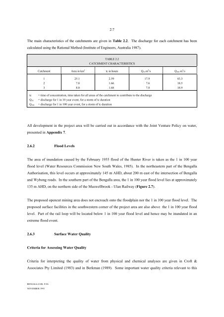
2:7<br />
The main characteristics <strong>of</strong> the catchments are given in Table 2.2. The discharge for each catchment has been<br />
calculated using the Rational Method (Institute <strong>of</strong> Engineers, Australia 1987).<br />
TABLE 2.2<br />
CATCHMENT CHARACTERISTICS<br />
Catchment Area in km 2 tc in hours Q 10 m 3 /s Q 100 m 3 /s<br />
1<br />
25.1<br />
2.59<br />
17.9<br />
43.3<br />
2<br />
7.8<br />
1.66<br />
7.6<br />
18.5<br />
3<br />
8.0<br />
1.68<br />
7.8<br />
18.9<br />
tc<br />
Q 10<br />
Q 100<br />
= time <strong>of</strong> concentration, time taken for all areas <strong>of</strong> the catchment to contribute to the discharge<br />
= discharge for 1 in 10 year event, for a storm <strong>of</strong> tc duration<br />
= discharge for 1 in 100 year event, for a storm <strong>of</strong> tc duration<br />
All development in the project area will be carried out in accordance with the Joint Venture Policy on water,<br />
presented in Appendix 7.<br />
2.6.2 Flood Levels<br />
The area <strong>of</strong> inundation caused by the February 1955 flood <strong>of</strong> the Hunter River is taken as the 1 in 100 year<br />
flood level (Water Resources Commission New South Wales, 1985). In the northeastern part <strong>of</strong> the <strong>Bengalla</strong><br />
Authorisation, this level occurs at approximately 145 m AHD, about 200 m east <strong>of</strong> the intersection <strong>of</strong> <strong>Bengalla</strong><br />
and Wybong roads. In the southern part <strong>of</strong> the <strong>Bengalla</strong> area, the 1 in 100 year flood level lies at approximately<br />
135 m AHD, on the northern side <strong>of</strong> the Muswellbrook - Ulan Railway (Figure 2.7).<br />
The proposed opencut mining area does not encroach onto the floodplain nor the 1 in 100 year flood level. The<br />
proposed surface facilities in the southwestern corner <strong>of</strong> the project area are also above the 1 in 100 year flood<br />
level. <strong>Part</strong> <strong>of</strong> the rail loop will be located below 1 in 100 year flood level and hence may be inundated in an<br />
extreme flood event.<br />
2.6.3 Surface Water Quality<br />
Criteria for Assessing Water Quality<br />
Criteria for interpreting the quality <strong>of</strong> water from physical and chemical analyses are given in Cr<strong>of</strong>t &<br />
Associates Pty Limited (1983) and in Berkman (1989). Some important water quality criteria relevant to this<br />
BENGALLA EIS. F156<br />
NOVEMBER <strong>1993</strong>