Conservation Science in the RSPB 2006
Conservation Science in the RSPB 2006
Conservation Science in the RSPB 2006

You also want an ePaper? Increase the reach of your titles
YUMPU automatically turns print PDFs into web optimized ePapers that Google loves.
22<br />
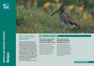
Mapp<strong>in</strong>g moorland habitats for birds<br />
us<strong>in</strong>g satellite images<br />
The abundance of golden plovers was<br />
poorly predicted by satellite imagery.<br />
Chris Gomersall (rspb-images.com)<br />
Uplands and blanket bogs <strong>in</strong> <strong>the</strong><br />
UK are of national and<br />
<strong>in</strong>ternational conservation<br />
significance, but some key bird<br />
populations <strong>the</strong>re have recently<br />
decl<strong>in</strong>ed. Understand<strong>in</strong>g <strong>the</strong><br />
reasons for this depends on good<br />
<strong>in</strong>formation on both birds and<br />
<strong>the</strong>ir habitats, but <strong>the</strong> extent of<br />
<strong>the</strong>se areas means this may be<br />
difficult to obta<strong>in</strong> us<strong>in</strong>g<br />
conventional methods.<br />
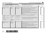
Comparison of <strong>the</strong> amount of hea<strong>the</strong>r <strong>in</strong> a subset of 26 2-km 2<br />
survey plots <strong>in</strong> south-east Scotland estimated from a supervised<br />
classification of a Landsat7 image (predicted) and derived from<br />
field-collected data (observed). Two data po<strong>in</strong>ts overlap.<br />
Prediced % hea<strong>the</strong>r<br />
80<br />
60<br />
40<br />
20<br />
The <strong>RSPB</strong> and <strong>the</strong> Scottish<br />
Agricultural College explored <strong>the</strong><br />
potential of satellite imagery to map<br />
moorland vegetation over extensive<br />
areas. Satellites measure differences<br />
<strong>in</strong> light reflected by different land<br />
cover. Us<strong>in</strong>g a subset of habitat data<br />
collected <strong>in</strong> a previous study,<br />
differences <strong>in</strong> reflectance between<br />
different plants were used to<br />
produce predicted vegetation maps<br />
for south-east Scotland,<br />
dist<strong>in</strong>guish<strong>in</strong>g <strong>the</strong> ma<strong>in</strong> plant species<br />
or taxa. These predictions were<br />
tested aga<strong>in</strong>st <strong>the</strong> rema<strong>in</strong><strong>in</strong>g data <strong>in</strong><br />
<strong>the</strong> reference set.<br />
Although <strong>the</strong> reference data had not<br />
been collected specifically for use<br />
with remote sens<strong>in</strong>g, common<br />
species (eg hea<strong>the</strong>r, purple moor<br />
grass) were mapped accurately.<br />
Relatively scarce plants (eg tall<br />
rushes, moss) were not so well<br />
mapped and predictions of variation<br />
<strong>in</strong> vegetation height were<br />
relatively weak.<br />
0<br />
0 20 40 60 80<br />
Observed % hea<strong>the</strong>r<br />
Us<strong>in</strong>g bird:habitat association<br />
models developed <strong>in</strong> <strong>the</strong> earlier<br />
study for red grouse and golden