remote sensing techniques for land use classification - GERS ...
remote sensing techniques for land use classification - GERS ...
remote sensing techniques for land use classification - GERS ...

Create successful ePaper yourself
Turn your PDF publications into a flip-book with our unique Google optimized e-Paper software.
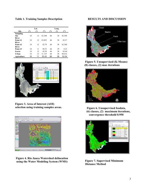
Table 1. Training Samples Description<br />
RESULTS AND DISCUSSION<br />
Lat.<br />
Long.<br />
Site (°) (') (") (°) (') (")<br />
Sampling<br />
Site 18 12 43.248 66 38 42.296<br />
River<br />
Point #1 18 12 43.025 66 38 42.27<br />
River<br />
Point #2 18 12 42.79 66 38 42.388<br />
River<br />
Point #3 18 11 50.53 66 39 0.23<br />
Forest 18 12 42.59 66 38 42.64<br />
Urban 18 12 11.135 66 38 48.632<br />
Agriculture 18 11 53.43 66 38 52.04<br />
Figure 5. Unsupervised (K-Means)<br />
(8) classes, (2) max iterations<br />
Figure 3. Area of Interest (AOI)<br />
selection using training samples areas.<br />
Figure 6. Unsupervised Isodata,<br />
(6) classes, (2) maximum iterations,<br />
convergence threshold 0.950<br />
F<br />
i<br />
g<br />
u<br />
r<br />
e<br />
Figure 4. Río Jauca Watershed delineation<br />
using the Water Modeling System (WMS)<br />
Figure 7. Supervised Minimum<br />
Distance Method<br />
3