USE PERMIT APPLICATION - City of Scotts Valley
USE PERMIT APPLICATION - City of Scotts Valley
USE PERMIT APPLICATION - City of Scotts Valley

Create successful ePaper yourself
Turn your PDF publications into a flip-book with our unique Google optimized e-Paper software.
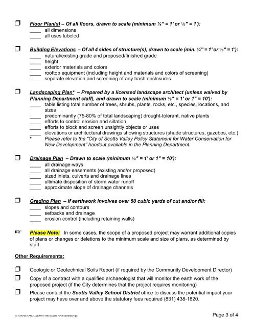
Floor Plan(s) – Of all floors, drawn to scale (minimum ¼” = 1' or c" = 1'):<br />
____ all dimensions<br />
____ all uses labeled<br />
Building Elevations – Of all 4 sides <strong>of</strong> structure(s), drawn to scale (min. ¼” = 1' or c" = 1'):<br />
____ natural/existing grade and proposed/finished grade<br />
____ height<br />
____ exterior materials and colors<br />
____ ro<strong>of</strong>top equipment (including height and materials and colors <strong>of</strong> screening)<br />
____ separate elevation and screening <strong>of</strong> any trash enclosures<br />
Landscaping Plan* – Prepared by a licensed landscape architect (unless waived by<br />
Planning Department staff), and drawn to scale (minimum c" = 1' or 1" = 10'):<br />
____ table listing total number <strong>of</strong> trees, shrubs, plants, rocks, etc., species, locations, and<br />
sizes<br />
____ predominantly (75-80% <strong>of</strong> total landscaping) drought-tolerant, native plants<br />
____ efforts to control erosion and siltation<br />
____ efforts to block and screen unsightly objects or uses<br />
____ elevations or architectural drawings showing structures (shade structures, gazebos, etc.)<br />
* Please refer to the “<strong>City</strong> <strong>of</strong> <strong>Scotts</strong> <strong>Valley</strong> Policy Statement for Water Conservation for<br />
New Development” handout available in the Planning Department.<br />
Drainage Plan – Drawn to scale (minimum c" = 1' or 1" = 10'):<br />
____ all drainage-ways<br />
____ all drainage easements (existing and/or proposed)<br />
____ sized inlets, culverts and drainage lines<br />
____ ultimate disposition <strong>of</strong> storm water run<strong>of</strong>f<br />
____ approximate slope <strong>of</strong> drainage channels<br />
Grading Plan – If earthwork involves over 50 cubic yards <strong>of</strong> cut and/or fill:<br />
____ slopes and contours<br />
____ setbacks and drainage<br />
____ erosion control (including retaining walls)<br />
Please Note: In some cases, the scope <strong>of</strong> a proposed project may warrant additional copies<br />
<strong>of</strong> plans or changes or deletions to the minimum scale and size <strong>of</strong> plans, as determined by<br />
staff.<br />
Other Requirements:<br />
<br />
<br />
<br />
Geologic or Geotechnical Soils Report (if required by the Community Development Director)<br />
Copy <strong>of</strong> a contract with a qualified archaeologist that will monitor the earth work <strong>of</strong> the<br />
proposed project (if the <strong>City</strong> determines that the project requires monitoring)<br />
Please contact the <strong>Scotts</strong> <strong>Valley</strong> School District <strong>of</strong>fice to discuss the potential impact your<br />
project may have over and above the statutory fees required (831) 438-1820.<br />
P:\FORMS\<strong>APPLICATION</strong> FORMS\appl-NewUsePermit.wpd Page 3 <strong>of</strong> 4