Flow routing in mangrove forests: field data ... - UT Proceedings
Flow routing in mangrove forests: field data ... - UT Proceedings
Flow routing in mangrove forests: field data ... - UT Proceedings

You also want an ePaper? Increase the reach of your titles
YUMPU automatically turns print PDFs into web optimized ePapers that Google loves.
DOI: 10.3990/2.186<br />
<strong>Flow</strong> <strong>rout<strong>in</strong>g</strong> <strong>in</strong> <strong>mangrove</strong> <strong>forests</strong>:<br />
<strong>field</strong> <strong>data</strong> obta<strong>in</strong>ed <strong>in</strong> Trang, Thailand<br />
E.M. Horstman 1,2 , C.M. Dohmen-Janssen 1 , T.J. Bouma 2,3,4 , S.J.M.H. Hulscher 1<br />
1 Water Eng<strong>in</strong>eer<strong>in</strong>g and Management, University of Twente, P.O. Box 217, 7500 AE Enschede, The Netherlands.<br />
E.M.Horstman@utwente.nl; C.M.Dohmen-Janssen@utwente.nl; S.J.M.H.Hulscher@utwente.nl<br />
2 S<strong>in</strong>gapore-Delft Water Alliance, National University of S<strong>in</strong>gapore, Eng<strong>in</strong>eer<strong>in</strong>g Drive 2, 117576 S<strong>in</strong>gapore.<br />
3 Mar<strong>in</strong>e & Coastal Systems, Deltares, P.O. Box 177, 2629 HD Delft, The Netherlands.<br />
4 Netherlands Institute of Ecology, P.O. Box 140, 4400 AC Yerseke, The Netherlands.<br />
T.Bouma@nioo.knaw.nl<br />
ABSTRACT<br />
Mangroves grow <strong>in</strong> the <strong>in</strong>tertidal parts of sheltered tropical coastl<strong>in</strong>es, facilitat<strong>in</strong>g coastal stabilization and wave attenuation.<br />
Mangroves are widely threatened nowadays, although past studies have <strong>in</strong>dicated their contribution to coastal safety. Most of these<br />
studies were based on numerical model<strong>in</strong>g however and a proper <strong>data</strong>base with <strong>field</strong> observations is lack<strong>in</strong>g yet. This paper presents<br />
part of the results of an extensive <strong>field</strong> campaign <strong>in</strong> a <strong>mangrove</strong> area <strong>in</strong> Trang Prov<strong>in</strong>ce, Thailand. The study area covers the outer<br />
border of an estuar<strong>in</strong>e <strong>mangrove</strong> creek catchment. Data have been collected on elevation, vegetation, water levels, flow directions and<br />
flow velocities throughout this study area. Due to the tough conditions <strong>in</strong> the <strong>field</strong>, develop<strong>in</strong>g a suitable method for <strong>data</strong> collection and<br />
process<strong>in</strong>g has been a major challenge <strong>in</strong> this study. Analysis of the hydrodynamic <strong>data</strong> uncovers the change of flow directions and<br />
velocities throughout a <strong>mangrove</strong> creek catchment over one tidal cycle. In the <strong>in</strong>itial stages of flood<strong>in</strong>g and the f<strong>in</strong>al stages of ebb<strong>in</strong>g,<br />
creeks supply water to the lower elevated parts of the <strong>mangrove</strong>s. In between these stages, the entire forest border<strong>in</strong>g the estuary is<br />
flooded and flow directions are perpendicular to the forest fr<strong>in</strong>ge. <strong>Flow</strong> velocities with<strong>in</strong> the creeks are still substantially higher than<br />
those with<strong>in</strong> the forest, as the creeks also supply water to the back <strong>mangrove</strong>s. These <strong>in</strong>sights <strong>in</strong> flow <strong>rout<strong>in</strong>g</strong> are promis<strong>in</strong>g for the<br />
future analysis of sediment <strong>in</strong>put and distribution <strong>in</strong> <strong>mangrove</strong>s.<br />
INTRODUCTION<br />
Mangroves form an <strong>in</strong>dispensable ecosystem <strong>in</strong> the <strong>in</strong>tertidal<br />
area of many tropical and sub-tropical coastl<strong>in</strong>es. Mangrove<br />
vegetation consists of salt tolerant trees and shrubs, able to resist<br />
the hydrodynamic forces faced <strong>in</strong> the <strong>in</strong>tertidal parts of sheltered<br />
coastl<strong>in</strong>es such as estuaries and lagoons [August<strong>in</strong>us, 1995]. Due<br />
to their location and persistence, <strong>mangrove</strong>s play an important role<br />
<strong>in</strong> coastal stabilization [Alongi, 2008; August<strong>in</strong>us, 1995;<br />
Furukawa and Wolanski, 1996; Krauss et al., 2003; Van Santen et<br />
al., 2007] and wave attenuation [Br<strong>in</strong>kman, 2006; Hong Phuoc<br />
and Massel, 2006; Mazda et al., 2006; Quartel et al., 2007].<br />
Despite this key-function of <strong>mangrove</strong>s <strong>in</strong> the <strong>in</strong>tertidal area, they<br />
are <strong>in</strong> rapid decl<strong>in</strong>e. Accord<strong>in</strong>g to the most recent estimate of<br />
global <strong>mangrove</strong> area there is only 13.8 million ha [Giri et al.,<br />
2011] left of the 18.8 million ha of <strong>mangrove</strong> cover found<br />
worldwide <strong>in</strong> 1980 [FAO, 2007]. Hence s<strong>in</strong>ce 1980 the <strong>mangrove</strong><br />
area decreased by about 27% and although annual <strong>mangrove</strong><br />
losses are slow<strong>in</strong>g down, recent annual loss rates are still around<br />
1% [Bosire et al., 2008; FAO, 2007]. Therefore there is an urgent<br />
need to unravel the contribution of <strong>mangrove</strong>s to long-term coastal<br />
safety <strong>in</strong> order to <strong>in</strong>crease awareness of the need for and hence the<br />
success of <strong>mangrove</strong> preservation.<br />
To date, studies on water flows through <strong>mangrove</strong> systems are<br />
limited. Hydrodynamic studies <strong>in</strong>to flow velocities focus on creekforest<br />
<strong>in</strong>teractions and the consequent tidal asymmetry and selfscour<strong>in</strong>g<br />
of tidal <strong>mangrove</strong> creeks [Aucan and Ridd, 2000;<br />
Furukawa et al., 1997; Mazda et al., 1995; Wolanski et al., 1980].<br />
This issue ga<strong>in</strong>ed <strong>in</strong>terest quite a while ago, s<strong>in</strong>ce flow <strong>rout<strong>in</strong>g</strong> is<br />
important for supply of e.g. sediment and nutrients to <strong>mangrove</strong>s<br />
[Wolanski et al., 1980]. Most studies <strong>in</strong>vestigate <strong>mangrove</strong><br />
hydrodynamics through numerical models, <strong>field</strong> <strong>data</strong> to calibrate<br />
and validate these models are sparse. Collection of <strong>field</strong> <strong>data</strong> is<br />
often limited <strong>in</strong> time and space; <strong>field</strong> campaigns usually last for a<br />
few days and often only one study site is taken <strong>in</strong>to account<br />
[Aucan and Ridd, 2000; Furukawa et al., 1997; Kobashi and<br />
Mazda, 2005]. Comprehensive <strong>field</strong> studies <strong>in</strong>to hydrodynamics<br />
with<strong>in</strong> <strong>mangrove</strong> <strong>forests</strong> are really sparse [Mazda et al., 1997],<br />
although this <strong>in</strong>formation is highly relevant for the distribution of<br />
sediments throughout the <strong>mangrove</strong> area [Furukawa et al., 1997].<br />
Mazda et al. [1997] and Kobashi & Mazda [2005] only made a<br />
start by extend<strong>in</strong>g knowledge on water flow<strong>in</strong>g through <strong>mangrove</strong><br />
<strong>forests</strong> by collect<strong>in</strong>g flow velocity <strong>data</strong> along transects through<br />
<strong>mangrove</strong>s. This procedure is practiced more often for <strong>data</strong><br />
collection on wave attenuation <strong>in</strong> <strong>mangrove</strong>s [Br<strong>in</strong>kman, 2006;<br />
Vo-Luong and Massel, 2008]. Studies l<strong>in</strong>k<strong>in</strong>g 2-dimensional flow<br />
<strong>rout<strong>in</strong>g</strong> through <strong>mangrove</strong>s to gradients <strong>in</strong> elevation and<br />
vegetation are unprecedented.<br />
A first step forward to <strong>in</strong>crease our understand<strong>in</strong>g of <strong>mangrove</strong><br />
function<strong>in</strong>g is to collect an extensive hydrodynamic <strong>data</strong>base <strong>in</strong><br />
the <strong>field</strong>. Integrated measurements on elevation, vegetation, water<br />
levels, flow velocities and flow directions throughout a <strong>mangrove</strong><br />
area are required to be able to unravel flow <strong>rout<strong>in</strong>g</strong> through<br />
<strong>mangrove</strong>s. This short-paper aims to shed a light on the<br />
importance of tidal creeks, which are a common feature <strong>in</strong><br />
<strong>mangrove</strong>s, for transport<strong>in</strong>g water <strong>in</strong>to <strong>mangrove</strong>s.<br />
Jubilee Conference Proceed<strong>in</strong>gs, NCK-Days 2012
A<br />
B<br />
C<br />
D<br />
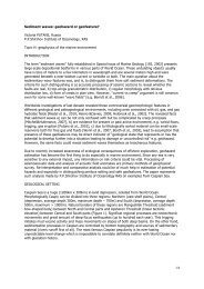
Figure 1. Geography of the study<br />
site: (A) Andaman coast of Thailand; (B) Trang prov<strong>in</strong>ce; (C) location off the study site <strong>in</strong> i the Kantang<br />
River estuary near<br />
Kantang Tai village (opposite the river); (D) elevation and<br />
vegetation map of the studiedd creek catchment.<br />
This paper presents <strong>field</strong> <strong>data</strong> obta<strong>in</strong>ed dur<strong>in</strong>g a <strong>field</strong> campaign<br />
<strong>in</strong> a <strong>mangrove</strong> catchment <strong>in</strong> Trang Prov<strong>in</strong>ce, Thailand, from<br />
January to May 2011. Section 2 gives an <strong>in</strong>troduction <strong>in</strong>to the<br />
geography of this study site. Section 3 presents how<br />
hydrodynamic <strong>data</strong> are obta<strong>in</strong>ed with<strong>in</strong> the study area. This<br />
section describes procedures for both <strong>data</strong> collection and <strong>data</strong><br />
process<strong>in</strong>g. Next, results of the <strong>data</strong> analysis are presented. These<br />
results will be discussed subsequently, lead<strong>in</strong>g l to some<br />
prelim<strong>in</strong>ary conclusions follow<strong>in</strong>g from thee analysis of the<br />
obta<strong>in</strong>ed <strong>field</strong> <strong>data</strong>.<br />
STUDY<br />
SITE<br />
The study site<br />
(7 o 19’45’’N; 99 o 29’17’’E) is located <strong>in</strong> the<br />
Kantang River estuary at the east coast of southern Thailand, , <strong>in</strong><br />
Trang Prov<strong>in</strong>ce (Figure 1A-C). This area is partt of the convoluted<br />
Thai Andaman coast, consist<strong>in</strong>g of many embayments, islands and<br />
islets offer<strong>in</strong>g a perfect habitat to<br />
<strong>mangrove</strong>s. This paper focusses<br />
on <strong>data</strong> collected <strong>in</strong> part of a creek catchment directly border<strong>in</strong>g<br />
the Kantang River<br />
(Figure 1C). The study areaa is tide dom<strong>in</strong>ated<br />
[Woodroffe, 1992] be<strong>in</strong>g exposed to a mixedd semi-diurnal tide<br />
with a tidal amplitude of 3.5 m. The study area only covers part of<br />
the catchment fed<br />
by the ma<strong>in</strong> creek border<strong>in</strong>gg the northern edge<br />
of the study area (Figure 1D) and<br />
forms the fr<strong>in</strong>ge of a much more<br />
extended <strong>mangrove</strong> forest extend<strong>in</strong>g about 1 km<br />
<strong>in</strong>land.<br />
The geography of the study area has been mapped extensively<br />
with Trimble survey equipment (SPS 700-S6 Total Station andd R-<br />
6 Real Time K<strong>in</strong>ematic GPS). Obta<strong>in</strong>ed elevation <strong>data</strong> has been<br />
<strong>in</strong>terpolated (ord<strong>in</strong>ary krig<strong>in</strong>g with exponential semivariogram<br />
model; 0.7 m resolution) and plotted with respect to a datum just<br />
<strong>in</strong> front of the forest fr<strong>in</strong>ge (N0 <strong>in</strong> Figure 3A) <strong>in</strong> Figure 1D. The<br />
study area shows a pronounced 1 m high cliff at the <strong>in</strong>terface with<br />
the estuary. Elevation of the forest floor <strong>in</strong>creases while mov<strong>in</strong>g<br />
further <strong>in</strong>land, although deep creeks penetrate far <strong>in</strong>to the forest<br />
and<br />
show <strong>in</strong>cisions bordered by<br />
dist<strong>in</strong>ct creekk banks. The ma<strong>in</strong><br />
creek <strong>in</strong> the north is over 2 m deep. While penetrat<strong>in</strong>g deeper <strong>in</strong>to<br />
the forest, the creeks tend to get narrower and shallower s and they<br />
end<br />
<strong>in</strong> a depression <strong>in</strong> the centre of the study area. The mounds <strong>in</strong><br />
the sheltered centre and west of<br />
the study areaa are mud mounds<br />
built by mud lobsters.<br />
Four dist<strong>in</strong>ct vegetation zones are mapped <strong>in</strong>-sitfr<strong>in</strong>ge fac<strong>in</strong>g the Kantang river is<br />
and are shown<br />
<strong>in</strong> Figure 1D as well. The forest<br />
densely covered with Rizophora trees. Directly beh<strong>in</strong>d this fr<strong>in</strong>ge,<br />
a less dense forest cover is found consist<strong>in</strong>g of a mixx of<br />
Rizophora, Avicennia, Sonneratia, Bruguieraa and Xylocarpus<br />
trees. Along the ma<strong>in</strong>n creeks <strong>in</strong> thee study area the same mix of<br />
trees is observed with w an understory of Acanthus shrubs.<br />
Rizophora trees are dom<strong>in</strong>ant <strong>in</strong> the <strong>in</strong>ner part of thee study area.<br />
METHODO<br />
OLOGY<br />
Data collection<br />
<strong>Flow</strong><br />
velocities andd directions have been monitored throughoutt<br />
the study area with Acoustic Doppler Velocimeters (ADV’s,<br />
Nortek) with cable probes. ADV’s turned out to be b very suitable<br />
equipment for monitor<strong>in</strong>g hydrodynamics <strong>in</strong> coastal wetlands<br />
[Horstman et al., 2011]. The ADVV probes have been mounted<br />
downward look<strong>in</strong>g, with one receiver aligned to the north,<br />
monitor<strong>in</strong>g flow velocities at just 7 cm above the bed b (Figure 2).<br />
With this configuration, the probes’ sensors were located up to 23<br />
cm above the bed so s m<strong>in</strong>imum water depths of 25 cm weree<br />
required for <strong>data</strong> collection. End bells of the ADV’s battery and<br />
memory hous<strong>in</strong>g conta<strong>in</strong>ed pressure sensors and these weree<br />
mounted to monitor att 7 cm above the substrate as well (Figure 2).<br />
Hydrodynamic <strong>data</strong> have h been collected at 16 Hz with a burst<br />
length of 4096 samples (i.e. 256 s) and a burst <strong>in</strong>terval of 15000<br />
seconds (25 m<strong>in</strong>). Three ADV’s were <strong>in</strong>stalled dur<strong>in</strong>g spr<strong>in</strong>g tide<br />
(due to<br />
the necessity of spr<strong>in</strong>g low w tide for <strong>in</strong>stallation <strong>in</strong> some<br />
locations) and were deployed d dur<strong>in</strong>g an entire spr<strong>in</strong>g neap tidal<br />
cycle (i.e. 14 days) each time.<br />
Figure 2. Acoustic Doppler Velocimeter dur<strong>in</strong>g deployment <strong>in</strong><br />
the <strong>field</strong> just <strong>in</strong> frontt of the <strong>mangrove</strong> fr<strong>in</strong>ge. Downward look<strong>in</strong>g<br />
mount<strong>in</strong>g to monitorr flow velocitiess at 7 cm above the bed. Note<br />
the black canister <strong>in</strong> the back, conta<strong>in</strong><strong>in</strong>g the pressure sensor.<br />
148<br />
Jubilee Conference Proceed<strong>in</strong>gs, NCK-Days 2012
Horstman, Dohmen-Janssen, Boumaa and Hulscher<br />
Data process<strong>in</strong>g<br />
The output of each ADV deployment conta<strong>in</strong>s three velocity<br />
components, threee correlation values and water pressure. These<br />
<strong>data</strong> have been averaged per burst and low<br />
quality <strong>data</strong> are<br />
removed by filter<strong>in</strong>g for correlations lower than 70%. Next, <strong>data</strong><br />
series collected <strong>in</strong><br />
four subsequent deployments (due to limited<br />
equipment availability) have been comb<strong>in</strong>ed. ADV’s were<br />
deployed such that every <strong>data</strong> series conta<strong>in</strong>ed one common <strong>data</strong><br />
collection po<strong>in</strong>t. Three <strong>data</strong> series conta<strong>in</strong>ed velocities v measured<br />
<strong>in</strong> the center of the<br />
study area (N3 <strong>in</strong> Figure 3A). From every <strong>data</strong><br />
set for this central <strong>data</strong> collection po<strong>in</strong>t, <strong>data</strong> for f one s<strong>in</strong>gle tidal<br />
<strong>in</strong>undation have been selected show<strong>in</strong>g equal <strong>in</strong>undation depths<br />
and<br />
flow velocities. Subsequently, concurrent measurements<br />
(<strong>in</strong>ternal clocks of the ADV’s provided time stamps) s have been<br />
selected for the surround<strong>in</strong>g <strong>data</strong>a po<strong>in</strong>ts from each series (K3 and<br />
L3, , N0 and N1, N4 and O3 respectively). For the f<strong>in</strong>al <strong>data</strong> series,<br />
the reference <strong>data</strong> po<strong>in</strong>t was located <strong>in</strong> the ma<strong>in</strong>n creek to the north<br />
<strong>in</strong>stead (K3). One tidal peak was selected from these <strong>data</strong>a to<br />
resemble <strong>in</strong>undation depths and velocity components of the<br />
representative tidal <strong>in</strong>undation as it was found before for this<br />
location. Then the timestamp of this tidal peak facilitated the<br />
selection of concurrent s<strong>in</strong>gle tide <strong>data</strong> for the other two <strong>data</strong><br />
collection po<strong>in</strong>ts <strong>in</strong> the m<strong>in</strong>or creeks to the west and south off the<br />
catchment (N5 and P1 respectively). By this procedure, three-<br />
po<strong>in</strong>ts throughout the study area represent<strong>in</strong>g equal tidal<br />
conditions (tidal stage and amplitude).<br />
dimensional flow velocity <strong>data</strong> have been assembled for n<strong>in</strong>e <strong>data</strong><br />
RESULTS<br />
Figure 3 presents the result<strong>in</strong>g temporal sequence of flow<br />
velocity patterns throughout the study area (positions are <strong>in</strong>dicated<br />
<strong>in</strong> Figure 3A) for<br />
one tidal cycle for which the <strong>field</strong> <strong>data</strong> have<br />
been merged. High slack tide is around 23:40 h for this <strong>in</strong>stance.<br />
Inflow <strong>in</strong> the ma<strong>in</strong><br />
creek to the north of the study area is observed<br />
from<br />
around 17:30 h onwards, but was not observed at that time<br />
yet s<strong>in</strong>ce the ADV<br />
<strong>in</strong> this creek was located off the thalweg (due<br />
to shipp<strong>in</strong>g). Dataa coverage starts at 19 h, whenn the water depth at<br />
K3 exceeds the required m<strong>in</strong>imum depth (i.e. 25 cm). Figure 4<br />
shows the development of the current velocitiess observed at K3. It<br />
shows that on the <strong>in</strong>itial stages of flood (positive current<br />
velocities), with<strong>in</strong><br />
creek flow velocities are about 0.1 m/s only.<br />
This rapidly changes on <strong>in</strong>itiation of flood<strong>in</strong>g of the <strong>mangrove</strong>s.<br />
The<br />
lowest areas of the <strong>mangrove</strong><br />
forest are located at about 1. .6 m<br />
elevation (w.r.t. N0). When thesee areas start to <strong>in</strong>undate, suddenly<br />
large volumes of water need to be transported <strong>in</strong>to the <strong>mangrove</strong>s,<br />
caus<strong>in</strong>g a rapid <strong>in</strong>crease <strong>in</strong> creek discharge and hence of with<strong>in</strong><br />
creek flow velocities. This situation is shown <strong>in</strong> figure 3B; water<br />
is transported through the creeks <strong>in</strong>to the study area. a<br />
At the same <strong>in</strong>stance, however, the <strong>mangrove</strong>s also start to<br />
<strong>in</strong>undate directly from the forest fr<strong>in</strong>ge border<strong>in</strong>g the estuary.<br />
With<strong>in</strong> half an hour after <strong>in</strong>itiation of flow velocity measurements<br />
at N3, a change <strong>in</strong> current directions is observed (see Figuree 3C<br />
and<br />
Figure 4). Once the entire study area is <strong>in</strong>undated, <strong>in</strong>clud<strong>in</strong>g<br />
the bank separat<strong>in</strong>g the forest fr<strong>in</strong>ge from the central c parts off the<br />
catchment, a uniform flow direction perpendicular to the forest<br />
fr<strong>in</strong>ge is observed. This <strong>in</strong>dicates that water throughout the study<br />
area is flow<strong>in</strong>g parallel to the ma<strong>in</strong> creek now<br />
and that it flows<br />
directly from the estuary <strong>in</strong>to the<br />
forest. <strong>Flow</strong> velocities with<strong>in</strong>n the<br />
creeks stay significantly larger though, s<strong>in</strong>ce huge quantities of<br />
water are required to t <strong>in</strong>undate the extensive <strong>mangrove</strong> areaa<br />
located<br />
to the west off the studied area. With<strong>in</strong> creek water depths<br />
are larger and bottom friction with<strong>in</strong> creeks is negligible compared<br />
to shear stresses experienced with<strong>in</strong> the forest vegetation,<br />
facilitat<strong>in</strong>g the rapid supply of water to the back <strong>mangrove</strong>s<br />
throughh these creeks.<br />
When gett<strong>in</strong>g close to high tide, a rapid decrease of flow<br />
velocities throughout the study area is observed (Figure 3D) until<br />
slack tide. Figure 3E shows that at the turn<strong>in</strong>g off the tide, flow<br />
velocities throughout the study area have reversed towards the<br />
estuary<br />
already, whilee flow velocities observed with<strong>in</strong> the creek<br />
are still directed to the west. This iss caused by thee fact that flow<br />
velocities have been monitored at 7 cm above the creek bed.<br />
Higher<br />
up <strong>in</strong> the water column at K3 (at levels exceed<strong>in</strong>g the<br />
elevation of the forest floor), floww velocities turn concurrently<br />
with the flow velocities throughout the studied <strong>mangrove</strong> forest.<br />
Dur<strong>in</strong>g ebb tide, the <strong>in</strong>verse sequence of events is observed as<br />
dur<strong>in</strong>g flood<strong>in</strong>g of the forest. Rapidly <strong>in</strong>creas<strong>in</strong>g negative flow<br />
velocities are observed on the <strong>in</strong>itiation of ebb tide. <strong>Flow</strong><br />
velocities throughout the study area a are directed perpendicular to<br />
the forest fr<strong>in</strong>ge aga<strong>in</strong>, discharg<strong>in</strong>g directly <strong>in</strong>to the estuary<br />
(Figure<br />
3F&G). Only <strong>in</strong> the f<strong>in</strong>al stages of ebb<strong>in</strong>g from the forest<br />
a change <strong>in</strong> flow pattern is observed aga<strong>in</strong>, with water be<strong>in</strong>g<br />
discharged via the creeks towards thee estuary (Figure 3H).<br />
Although current patterns at ebb and flood show a clear<br />
resemblance, current velocities do not. Figure 4 shows that creek<br />
flows only show a short-term peak flow velocity (0.3 m/s for this<br />
<strong>in</strong>stance) dur<strong>in</strong>g floodd (only one <strong>data</strong> po<strong>in</strong>t, i.e. one burst), while<br />
flow velocities at ebb tide ma<strong>in</strong>ta<strong>in</strong>n a slightly lower maximumm<br />
speed for a much longer duration (dur<strong>in</strong>g five bursts). b This is<br />
caused by a delayed discharge fromm the forest due d to the highh<br />
vegetation roughness faced by the tidal currents. . On <strong>in</strong>com<strong>in</strong>g<br />
tide, the same roughness hampers the <strong>in</strong>flow of water <strong>in</strong>to the<br />
forest caus<strong>in</strong>g the delayed velocityy peak after flood<strong>in</strong>g f of the<br />
forest at a water level of 1.6 m. This sequence of flow velocities<br />
leads to self-scour<strong>in</strong>gg of the creeks, , which has been observed <strong>in</strong><br />
<strong>mangrove</strong> studies before [Mazda et al., 1995]. In contrary c to this<br />
asymmetric pattern observed o <strong>in</strong> tidal creek flows, with<strong>in</strong> forest<br />
flows do not show such a dist<strong>in</strong>ct difference between <strong>in</strong>flow at<br />
flood and outflow at ebb e tide (Figuree 4).<br />
Figure 4. Current velocities v observed with<strong>in</strong> thee creek (at K3)<br />
and <strong>in</strong> the center off the study areaa (N3). Velocities plotted are<br />
absolute magnitudess of the velocity<br />
vectors. Positive values are<br />
directed to the west, negative values to the east. The <strong>mangrove</strong>s<br />
start to <strong>in</strong>undate at a water level of f 1.6 m.<br />
Jubilee Conference Proceed<strong>in</strong>gs, NCK-Days 2012<br />
149
A<br />
BB<br />
C<br />
D<br />
E<br />
F<br />
G<br />
H<br />
Figure 3. N<strong>in</strong>e positions for flow<br />
velocity measurements are <strong>in</strong>dicated <strong>in</strong> (A). (B-H) Show the change of flow velocities and directions<br />
dur<strong>in</strong>g an entire tidal cycle (slack high tide att 23:40), from the <strong>in</strong>itial stages of fill<strong>in</strong>g of f the area to full <strong>in</strong>undation and a subsequent<br />
stages of discharge on outgo<strong>in</strong>g tide. L3 does not <strong>in</strong>undate deeper than about 20 cm and hence flow velocities could not bee measured.<br />
150<br />
Jubilee Conference Proceed<strong>in</strong>gs, NCK-Days 2012
Horstman, Dohmen-Janssen, Bouma and Hulscher<br />
DISCUSSION<br />
Although tidal flow patterns through the studied <strong>mangrove</strong> area<br />
are unraveled by show<strong>in</strong>g the flow velocities at different stages of<br />
flood<strong>in</strong>g and ebb<strong>in</strong>g, there is no clear-cut conclusion about the<br />
importance of tidal creeks <strong>in</strong> fill<strong>in</strong>g and empty<strong>in</strong>g of the<br />
<strong>mangrove</strong>s yet. <strong>Flow</strong> velocities presented <strong>in</strong> this paper only<br />
describe the situation at 7 cm above the bed. This velocity does at<br />
first not represent the velocity throughout the entire water column<br />
(as near bed flow velocities are significantly lower than those<br />
higher up <strong>in</strong> the water column). Measur<strong>in</strong>g flow velocities at<br />
higher levels would have been of little use however as <strong>in</strong> these<br />
cases required water depths for proper ADV function<strong>in</strong>g would<br />
hardly ever occur. Next, it was shown that <strong>in</strong> the creeks not even<br />
the direction of the water current is per se the same throughout the<br />
entire water column. So the present analysis does not yet quantify<br />
the contribution of creeks to <strong>mangrove</strong> hydrodynamics.<br />
CONCLUSIONS<br />
The prelim<strong>in</strong>ary analysis presented <strong>in</strong> this paper underl<strong>in</strong>es that<br />
creeks are ma<strong>in</strong>ly important for the <strong>in</strong>itial stages of tidal fill<strong>in</strong>g<br />
and f<strong>in</strong>al stages of tidal empty<strong>in</strong>g of the <strong>mangrove</strong>s. The near-bed<br />
flow velocities presented here are valuable <strong>in</strong>formation for the<br />
future analysis of sediment transport through <strong>mangrove</strong>s.<br />
Concurrently measured suspended sediment concentrations will be<br />
related to these flow velocities, so to <strong>in</strong>crease knowledge on<br />
sediment <strong>rout<strong>in</strong>g</strong> and deposition <strong>in</strong> <strong>mangrove</strong>s.<br />
ACKNOWLEDGEMENTS<br />
The authors gratefully acknowledge assistance <strong>in</strong> plann<strong>in</strong>g,<br />
facilitat<strong>in</strong>g and execut<strong>in</strong>g <strong>field</strong>work by M. Siemer<strong>in</strong>k (University<br />
of Twente), N.J.F. van den Berg (University of Twente), D. Galli<br />
(National University of S<strong>in</strong>gapore), T. B alke (Deltares/S<strong>in</strong>gapore-<br />
Delft Water Alliance), D.A. Friess (National University of<br />
S<strong>in</strong>gapore/S<strong>in</strong>gapore-Delft Water Alliance), E.L Webb (National<br />
University of S<strong>in</strong>gapore), C. Sudtongkong (Rajamangala<br />
University of Technology Srivijaya), Katai, Dumrong and Siron.<br />
Fieldwork for this paper has been executed under the NRCT<br />
research permit ‘Ecology and Hydrodynamics of Mangroves’<br />
(Project ID-2565). Also gratefully acknowledged is the support &<br />
contributions of the S<strong>in</strong>gapore-Delft Water Alliance (SDWA). The<br />
research presented <strong>in</strong> this work was carried out as part of the<br />
SDWA’s Mangrove research program (R-264-001-024-414).<br />
REFERENCES<br />
Alongi, D. M. (2008), Mangrove <strong>forests</strong>: Resilience, protection<br />
from tsunamis, and responses to global climate change, Estuar.<br />
Coast. Shelf Sci., 76(1), 1-13.<br />
Aucan, J., and P. V. Ridd (2000), Tidal asymmetry <strong>in</strong> creeks<br />
surrounded by saltflats and <strong>mangrove</strong>s with small swamp<br />
slopes, Wetlands Ecology and Management, 8(4), 223-232.<br />
August<strong>in</strong>us, P. G. E. F. (1995), Geomorphology and<br />
sedimentology of <strong>mangrove</strong>s, <strong>in</strong> Developments <strong>in</strong><br />
Sedimentology, edited by G. M. E. Perillo, pp. 333-357,<br />
Elsevier.<br />
Bosire, J. O., F. Dahdouh-Guebas, M. Walton, B. I. Crona, R. R.<br />
Lewis Iii, C. Field, J. G. Kairo, and N. Koedam (2008),<br />
Functionality of restored <strong>mangrove</strong>s: A review, Aquatic Botany,<br />
89(2), 251-259.<br />
Br<strong>in</strong>kman, R. M. (2006), Wave attenuation <strong>in</strong> <strong>mangrove</strong> <strong>forests</strong>:<br />
an <strong>in</strong>vestigation through <strong>field</strong> and theoretical studies, PhD<br />
thesis, 146 pp, James Cook University, Townsville.<br />
FAO (2007), The world's <strong>mangrove</strong>s, 1980-2005., 77 pp., Food<br />
and Agriculture Organization of the United Nations, Rome.<br />
Furukawa, K., and E. Wolanski (1996), Sedimentation <strong>in</strong><br />
Mangrove Forests, Mangroves and Salt Marshes, 1(1), 3-10.<br />
Furukawa, K., E. Wolanski, and H. Mueller (1997), Currents and<br />
sediment transport <strong>in</strong> <strong>mangrove</strong> <strong>forests</strong>, Estuar. Coast. Shelf<br />
Sci., 44(3), 301-310.<br />
Giri, C., E. Ochieng, L. L. Tieszen, Z. Zhu, A. S<strong>in</strong>gh, T.<br />
Loveland, J. Masek, and N. Duke (2011), Status and<br />
distribution of <strong>mangrove</strong> <strong>forests</strong> of the world us<strong>in</strong>g earth<br />
observation satellite <strong>data</strong>, Glob. Ecol. Biogeogr., 20(1), 154-<br />
159.<br />
Hong Phuoc, V. L., and S. R. Massel (2006), Experiments on<br />
wave motion and suspended sediment concentration at Nang<br />
Hai, Can Gio <strong>mangrove</strong> forest, Southern Vietnam, Oceanologia,<br />
48(1), 23-40.<br />
Horstman, E., T. Balke, T. Bouma, M. Dohmen-Janssen, and S.<br />
Hulscher (2011), Optimiz<strong>in</strong>g methods to measure<br />
hydrodynamics <strong>in</strong> coastal wetlands: evaluat<strong>in</strong>g the use and<br />
position<strong>in</strong>g of ADV, ADCP AND HR-ADCP.<br />
Kobashi, D., and Y. Mazda (2005), Tidal <strong>Flow</strong> <strong>in</strong> River<strong>in</strong>e-Type<br />
Mangroves, Wetlands Ecology and Management, 13(6), 615-<br />
619.<br />
Krauss, K. W., J. A. Allen, and D. R. Cahoon (2003), Differential<br />
rates of vertical accretion and elevation change among aerial<br />
root types <strong>in</strong> Micronesian <strong>mangrove</strong> <strong>forests</strong>, Estuar. Coast.<br />
Shelf Sci., 56(2), 251-259.<br />
Mazda, Y., N. Kanazawa, and E. Wolanski (1995), Tidal<br />
asymmetry <strong>in</strong> <strong>mangrove</strong> creeks, Hydrobiologia, 295(1), 51-58.<br />
Mazda, Y., M. Magi, Y. Ikeda, T. Kurokawa, and T. Asano<br />
(2006), Wave reduction <strong>in</strong> a <strong>mangrove</strong> forest dom<strong>in</strong>ated by<br />
Sonneratia sp., Wetlands Ecology and Management, 14(4), 365-<br />
378.<br />
Mazda, Y., E. Wolanski, B. K<strong>in</strong>g, A. Sase, D. Ohtsuka, and M.<br />
Magi (1997), Drag force due to vegetation <strong>in</strong> <strong>mangrove</strong><br />
swamps, Mangroves and Salt Marshes, 1(3), 193-199.<br />
Quartel, S., A. Kroon, P. G. E. F. August<strong>in</strong>us, P. Van Santen, and<br />
N. H. Tri (2007), Wave attenuation <strong>in</strong> coastal <strong>mangrove</strong>s <strong>in</strong> the<br />
Red River Delta, Vietnam, J. Asian Earth Sci., 29(4), 576-584.<br />
Van Santen, P., P. August<strong>in</strong>us, B. M. Janssen-Stelder, S. Quartel,<br />
and N. H. Tri (2007), Sedimentation <strong>in</strong> an estuar<strong>in</strong>e <strong>mangrove</strong><br />
system, J. Asian Earth Sci., 29(4), 566-575.<br />
Vo-Luong, P., and S. Massel (2008), Energy dissipation <strong>in</strong> nonuniform<br />
<strong>mangrove</strong> <strong>forests</strong> of arbitrary depth, J. Mar. Syst., 74(1-<br />
2), 603-622.<br />
Wolanski, E., M. Jones, and J. Bunt (1980), Hydrodynamics of a<br />
tidal creek-<strong>mangrove</strong> swamp system, Mar. Freshw. Res., 31(4),<br />
431-450.<br />
Woodroffe, C. D. (1992), Mangrove sediments and<br />
geomorphology, <strong>in</strong> Tropical <strong>mangrove</strong> ecosystems, edited by A.<br />
I. Robertson and D. M. Alongi, p. 329, American Geophysical<br />
Union, Wash<strong>in</strong>gton DC.<br />
Jubilee Conference Proceed<strong>in</strong>gs, NCK-Days 2012 151