The siting and design of aquaculture in the landscape: visual and ...
The siting and design of aquaculture in the landscape: visual and ...
The siting and design of aquaculture in the landscape: visual and ...

Create successful ePaper yourself
Turn your PDF publications into a flip-book with our unique Google optimized e-Paper software.
All <strong>the</strong> relevant elements <strong>of</strong> <strong>the</strong> proposed development should be <strong>in</strong>cluded <strong>in</strong> a <strong>visual</strong> assessment<br />
<strong>in</strong>clud<strong>in</strong>g any <strong>visual</strong>isations or photomontages used to support a plann<strong>in</strong>g application. A <strong>visual</strong><br />
assessment <strong>of</strong> <strong>of</strong>fshore equipment should <strong>in</strong>clude <strong>the</strong> cages, buoys <strong>and</strong> l<strong>in</strong>es, feed barges <strong>and</strong><br />
feed pipes, rafts, top nets, lift<strong>in</strong>g gear <strong>and</strong> light<strong>in</strong>g, huts <strong>and</strong> accommodation blocks. Any onshore<br />
elements that are part <strong>of</strong> <strong>the</strong> proposal, e.g. build<strong>in</strong>gs, jetties/pontoons, feed hoppers, access roads<br />
<strong>and</strong> any o<strong>the</strong>r relevant structures should also be <strong>in</strong>cluded <strong>in</strong> <strong>the</strong> <strong>visual</strong> assessment.<br />
An <strong>in</strong>troduction to <strong>visual</strong> assessment, <strong>in</strong>clud<strong>in</strong>g identify<strong>in</strong>g key viewpo<strong>in</strong>ts <strong>and</strong> assess<strong>in</strong>g <strong>the</strong><br />
significance <strong>of</strong> viewpo<strong>in</strong>ts is given <strong>in</strong> Section 2, on page XX para 2.7. Box 2 (later this section)<br />
illustrates a more detailed checklist <strong>of</strong> steps to be considered when undertak<strong>in</strong>g a <strong>visual</strong><br />
assessment.<br />
<strong>The</strong> <strong>visual</strong> assessment process allows applicants to explore <strong>the</strong> <strong>design</strong> <strong>of</strong> <strong>the</strong> proposal. This<br />
<strong>in</strong>cludes exam<strong>in</strong><strong>in</strong>g any mitigation measures that may l<strong>in</strong>k <strong>the</strong> proposal <strong>visual</strong>ly with <strong>the</strong> surround<strong>in</strong>g<br />
l<strong>and</strong>scape, perhaps by locat<strong>in</strong>g <strong>the</strong> structures aga<strong>in</strong>st a straight stretch <strong>of</strong> coast, or illustrat<strong>in</strong>g how<br />
big <strong>the</strong> size <strong>of</strong> <strong>the</strong> structure is <strong>in</strong> relation to <strong>the</strong> scale <strong>of</strong> <strong>the</strong> l<strong>and</strong>scape. At a more detailed level,<br />
illustrations or photomontages can be used to expla<strong>in</strong> how structures have been set aga<strong>in</strong>st trees<br />
or dark vegetation, or sited <strong>and</strong> arranged to reflect a regular l<strong>and</strong> use pattern.<br />
Viewpo<strong>in</strong>t selection: <strong>in</strong> assess<strong>in</strong>g <strong>the</strong> <strong>visual</strong> impact <strong>of</strong> <strong>aquaculture</strong> development, it is important to<br />
consider both <strong>the</strong> elevation <strong>of</strong> <strong>the</strong> viewpo<strong>in</strong>t <strong>and</strong> <strong>the</strong> proximity <strong>of</strong> <strong>the</strong> viewer to <strong>the</strong> development.<br />
For most structures, unless <strong>the</strong>y are well out to sea, <strong>the</strong>re will be both high-level <strong>and</strong> low-level<br />
viewpo<strong>in</strong>ts, <strong>and</strong> both distant <strong>and</strong> ‘close up’ views. It is difficult to <strong>design</strong> a structure which always<br />
looks good from every viewpo<strong>in</strong>t. <strong>The</strong> plann<strong>in</strong>g authority should be able to help you decide which<br />
viewpo<strong>in</strong>ts are <strong>the</strong> most important.<br />
4.1 Key considerations from high-level viewpo<strong>in</strong>ts<br />
––<br />
From a high-level viewpo<strong>in</strong>t, <strong>the</strong> contrast <strong>in</strong> texture between fish farm structures <strong>and</strong> <strong>the</strong><br />
smooth, reflective surface <strong>of</strong> <strong>the</strong> water is more obvious. <strong>The</strong> geometric shapes <strong>of</strong> l<strong>in</strong>es <strong>and</strong><br />
cages are also clearly visible.<br />
––<br />
High-level views where a dramatic panorama is ‘revealed’ suddenly <strong>and</strong> all at once when a<br />
road or footpath crests a high po<strong>in</strong>t or a pass are usually very sensitive – people anticipate a<br />
spectacular view, <strong>and</strong> <strong>the</strong>refore this view is scrut<strong>in</strong>ised closely.<br />
––<br />
From high up, it is easy to see how <strong>the</strong> shape, size, alignment <strong>and</strong> layout <strong>of</strong> cages relate to <strong>the</strong><br />
shape <strong>and</strong> scale <strong>of</strong> <strong>the</strong> coastl<strong>in</strong>e. It is also very obvious if l<strong>in</strong>es <strong>and</strong> cages do not lie parallel to<br />
<strong>the</strong> coast, for example, so th<strong>in</strong>k<strong>in</strong>g about <strong>the</strong> relationship between <strong>the</strong> alignment <strong>of</strong> structures<br />
<strong>and</strong> <strong>the</strong> shape <strong>of</strong> <strong>the</strong> coast is likely to be a more important consideration from high-level<br />
viewpo<strong>in</strong>ts than low-level viewpo<strong>in</strong>ts.<br />
––<br />
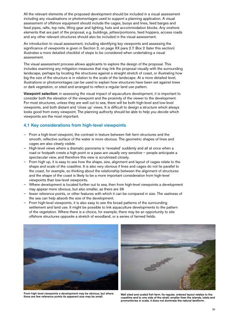
Where development is located fur<strong>the</strong>r out to sea, <strong>the</strong>n from high-level viewpo<strong>in</strong>ts a development<br />
may appear more obvious, but also smaller, as <strong>the</strong>re are 36<br />
––<br />
fewer reference po<strong>in</strong>ts, or o<strong>the</strong>r features with which it can be compared <strong>in</strong> size. <strong>The</strong> vastness <strong>of</strong><br />
<strong>the</strong> sea can help absorb <strong>the</strong> size <strong>of</strong> <strong>the</strong> development.<br />
––<br />
From high-level viewpo<strong>in</strong>ts, it is also easy to see <strong>the</strong> broad patterns <strong>of</strong> <strong>the</strong> surround<strong>in</strong>g<br />
settlement <strong>and</strong> l<strong>and</strong> use. It might be possible to l<strong>in</strong>k <strong>aquaculture</strong> developments to <strong>the</strong> pattern<br />
<strong>of</strong> <strong>the</strong> vegetation. Where <strong>the</strong>re is a choice, for example, <strong>the</strong>re may be an opportunity to site<br />
<strong>of</strong>fshore structures opposite a stretch <strong>of</strong> woodl<strong>and</strong>, or a series <strong>of</strong> farmed fields.<br />
From high level viewpo<strong>in</strong>ts a development may be obvious, but where<br />
<strong>the</strong>re are few reference po<strong>in</strong>ts its apparent size may be small.<br />
Well sited <strong>and</strong> scaled fish farm. Its regular, ordered layout relates to <strong>the</strong><br />
coastl<strong>in</strong>e <strong>and</strong> to one side <strong>of</strong> <strong>the</strong> strait; smaller than <strong>the</strong> isl<strong>and</strong>s, islets <strong>and</strong><br />
promontories <strong>in</strong> scale, it does not dom<strong>in</strong>ate <strong>the</strong> natural l<strong>and</strong>form.<br />
35