floodplain-strategy-strategic-plan.pdf | 3125.39 KB - South West NRM
floodplain-strategy-strategic-plan.pdf | 3125.39 KB - South West NRM
floodplain-strategy-strategic-plan.pdf | 3125.39 KB - South West NRM

Create successful ePaper yourself
Turn your PDF publications into a flip-book with our unique Google optimized e-Paper software.
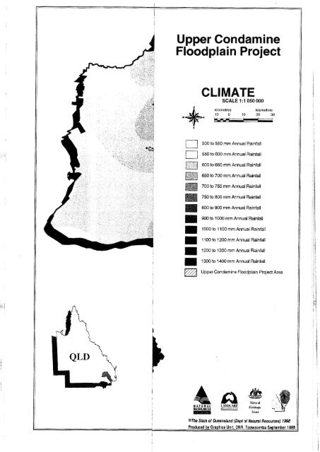
Upper Condamine<br />
ain Pro<br />
SCALE 1 : 1 050 000<br />
kilometres<br />
kilometres<br />
10 0 10 20 30<br />
500 to 550 mm Annual Rainfall<br />
1-1<br />
550 to 600 mm Annual Rainfall<br />
600 to 650 mm Annual Rainfall<br />
]-, CEt-<br />
650 to 700 mm Annual Rainfall<br />
700 to 750 mm Annual Rainfall<br />
750 to 800 mm Annual Rainfall<br />
800 to 900 mm Annual Rainfall<br />
11 900 to 1000 mm Annual Rainfall<br />
1000 to 1 100 mm Annual Rainfall<br />
1 100 to 1200 mm Annual Rainfall<br />
1200 to 1300 mm Annual Rainfall<br />
1300 to 1400 mm Annual Rainfall<br />
Upper Condamine Floodplain Project Area<br />
@The Shte of Queensland (Dept of Natural Resources) 1998<br />
Producsd by Graphics Unit. DNR, Towoomba September 1998