Space Operations
Space Operations
Space Operations

Create successful ePaper yourself
Turn your PDF publications into a flip-book with our unique Google optimized e-Paper software.
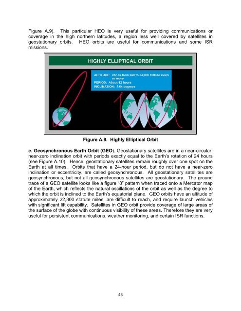
Figure A.9). This particular HEO is very useful for providing communications or<br />
coverage in the high northern latitudes, a region less well covered by satellites in<br />
geostationary orbits. HEO orbits are useful for communications and some ISR<br />
missions.<br />
Figure A.9. Highly Elliptical Orbit<br />
e. Geosynchronous Earth Orbit (GEO). Geostationary satellites are in a near-circular,<br />
near-zero inclination orbit with periods exactly equal to the Earth’s rotation of 24 hours<br />
(see Figure A.10). Hence, geostationary satellites remain roughly over one spot on the<br />
Earth at all times. Orbits that have a 24-hour period, but do not have a near-zero<br />
inclination or eccentricity, are called geosynchronous. All geostationary satellites are<br />
geosynchronous, but not all geosynchronous satellites are geostationary. The ground<br />
trace of a GEO satellite looks like a figure “8” pattern when traced onto a Mercator map<br />
of the Earth, which reflects the natural oscillations of the orbit as well as the degree to<br />
which the orbit is inclined to the Earth’s equatorial plane. GEO orbits have an altitude of<br />
approximately 22,300 statute miles, are difficult to reach, and require launch vehicles<br />
with significant lift capability. Satellites in GEO orbit provide coverage of large areas of<br />
the surface of the globe with continuous visibility of these areas. Therefore they are very<br />
useful for persistent communications, weather monitoring, and certain ISR functions.<br />
48