SRPMIC General Plan - Salt River Pima-Maricopa Indian Community
SRPMIC General Plan - Salt River Pima-Maricopa Indian Community
SRPMIC General Plan - Salt River Pima-Maricopa Indian Community

You also want an ePaper? Increase the reach of your titles
YUMPU automatically turns print PDFs into web optimized ePapers that Google loves.
<strong>Indian</strong> Bend Road<br />
McDonald Drive<br />
Chaparral Road<br />
<strong>Indian</strong><br />
School Road<br />
Thomas Road<br />
Thomas Road<br />
Oak Street<br />
Stapley Drive<br />
McKellips Road<br />
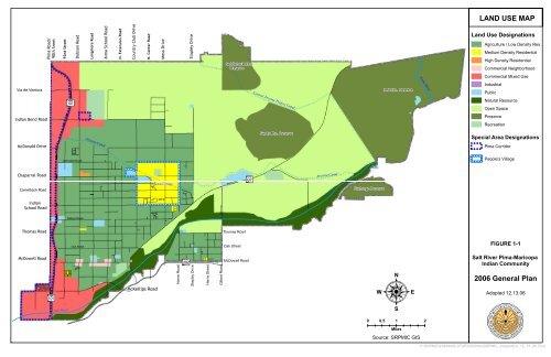
LAND USE MAP<br />
Saddleback Mtn.<br />
Preserve<br />
Land Use Designations<br />
Agriculture / Low Density Res.<br />
Medium Density Residential<br />
92nd Street<br />
Longmore Road<br />
N. Extension Road<br />
Country Club Drive<br />
N. Center Road<br />
Mesa Drive<br />
Stapley Drive<br />
<strong>Pima</strong> Road/<br />
90th Sreet<br />
Verde <strong>River</strong><br />
Via de Ventura<br />
Aß<br />
Red Mtn. Preserve<br />
Central Arizona Project Canal<br />
Sandy Mtn. Preserve<br />
Arizona Canal<br />
Jackrabbit Road<br />
Arizona Canal<br />
?Ð<br />
Beeline Hwy<br />
People's Village<br />
Camelback Road Exchange Preserve<br />
<strong>Salt</strong> <strong>River</strong><br />
<strong>Salt</strong> <strong>River</strong><br />
Osborn Road<br />
Oak Street<br />
McDowell Road<br />
Gilbert Road<br />
Alma School Road<br />
Dobson Road<br />
High Density Residential<br />
Commercial Neighborhood<br />
Commercial Mixed Use<br />
Industrial<br />
Public<br />
Natural Resource<br />
Open Space<br />
Preserve<br />
Recreation<br />
Special Area Designations<br />
!( !( !( !(!( !( !( !(! ( ! (<strong>Pima</strong> Corridor<br />
Gilbert Road<br />
!( !(<br />
People's Village<br />
FIGURE 1-1<br />
Aß<br />
Að<br />
McDowell Road<br />
<br />
0 0.5 1 2<br />
<strong>Salt</strong> <strong>River</strong> <strong>Pima</strong>-<strong>Maricopa</strong><br />
<strong>Indian</strong> <strong>Community</strong><br />
2006 <strong>General</strong> <strong>Plan</strong><br />
Horne Road<br />
Harris Street<br />
Adopted 12.13.06<br />
<strong>Salt</strong> <strong>River</strong><br />
Miles<br />
Source: <strong>SRPMIC</strong> GIS<br />
P:\<strong>SRPMIC</strong>\23444408_IFGP\GIS\Plots\<strong>SRPMIC</strong>_AdoptedLU_12_13_06_Final.