Establishment of Zoning Districts, Matrices and Map - City of St ...
Establishment of Zoning Districts, Matrices and Map - City of St ...
Establishment of Zoning Districts, Matrices and Map - City of St ...
You also want an ePaper? Increase the reach of your titles
YUMPU automatically turns print PDFs into web optimized ePapers that Google loves.
<strong>Establishment</strong> <strong>of</strong> <strong>Zoning</strong> <strong>Districts</strong>, <strong>Matrices</strong> <strong>and</strong> <strong>Map</strong><br />
<strong>City</strong> <strong>of</strong> <strong>St</strong>. Petersburg <strong>City</strong> Code – Chapter 16, L<strong>and</strong> Development Regulations<br />
Section 16.10.010 - <strong>Establishment</strong> <strong>of</strong> <strong>Zoning</strong> <strong>Districts</strong>, <strong>Matrices</strong> & <strong>Map</strong><br />
Sections:<br />
16.10.010.1 Zones<br />
16.10.010.2 <strong>Zoning</strong> <strong>Map</strong><br />
16.10.010.3 <strong>Zoning</strong> Boundary Lines<br />
16.10.010.4 <strong>Zoning</strong> District Regulations<br />
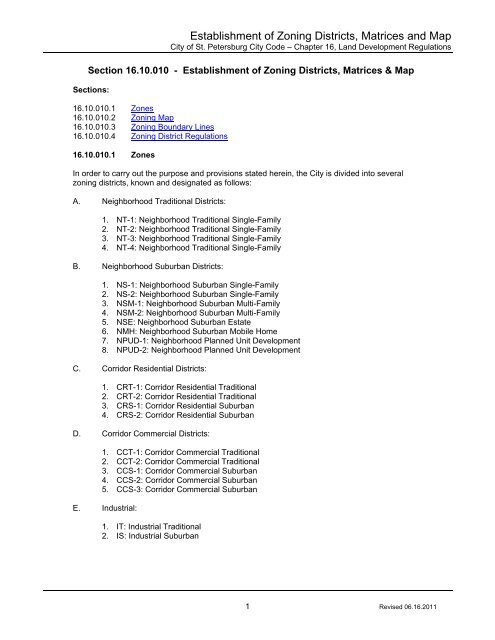
16.10.010.1 Zones<br />
In order to carry out the purpose <strong>and</strong> provisions stated herein, the <strong>City</strong> is divided into several<br />
zoning districts, known <strong>and</strong> designated as follows:<br />
A. Neighborhood Traditional <strong>Districts</strong>:<br />
1. NT-1: Neighborhood Traditional Single-Family<br />
2. NT-2: Neighborhood Traditional Single-Family<br />
3. NT-3: Neighborhood Traditional Single-Family<br />
4. NT-4: Neighborhood Traditional Single-Family<br />
B. Neighborhood Suburban <strong>Districts</strong>:<br />
1. NS-1: Neighborhood Suburban Single-Family<br />
2. NS-2: Neighborhood Suburban Single-Family<br />
3. NSM-1: Neighborhood Suburban Multi-Family<br />
4. NSM-2: Neighborhood Suburban Multi-Family<br />
5. NSE: Neighborhood Suburban Estate<br />
6. NMH: Neighborhood Suburban Mobile Home<br />
7. NPUD-1: Neighborhood Planned Unit Development<br />
8. NPUD-2: Neighborhood Planned Unit Development<br />
C. Corridor Residential <strong>Districts</strong>:<br />
1. CRT-1: Corridor Residential Traditional<br />
2. CRT-2: Corridor Residential Traditional<br />
3. CRS-1: Corridor Residential Suburban<br />
4. CRS-2: Corridor Residential Suburban<br />
D. Corridor Commercial <strong>Districts</strong>:<br />
1. CCT-1: Corridor Commercial Traditional<br />
2. CCT-2: Corridor Commercial Traditional<br />
3. CCS-1: Corridor Commercial Suburban<br />
4. CCS-2: Corridor Commercial Suburban<br />
5. CCS-3: Corridor Commercial Suburban<br />
E. Industrial:<br />
1. IT: Industrial Traditional<br />
2. IS: Industrial Suburban<br />
1 Revised 06.16.2011
<strong>Establishment</strong> <strong>of</strong> <strong>Zoning</strong> <strong>Districts</strong>, <strong>Matrices</strong> <strong>and</strong> <strong>Map</strong><br />
<strong>City</strong> <strong>of</strong> <strong>St</strong>. Petersburg <strong>City</strong> Code – Chapter 16, L<strong>and</strong> Development Regulations<br />
F. Centers:<br />
1. DC-C: Downtown Center, Core<br />
2. DC-1: Downtown Center<br />
3. DC-2: Downtown Center<br />
4. DC-3: Downtown Center<br />
5. DC-P: Downtown Center, Parks<br />
6. RC-1: Retail Center<br />
7. RC-2: Retail Center<br />
8. EC-1: Employment Center<br />
9. IC: Institutional Center<br />
G. Preservation<br />
1. PRES: Preservation<br />
16.10.010.2 <strong>Zoning</strong> <strong>Map</strong><br />
The boundaries <strong>of</strong> the zoning districts are hereby established as set forth on maps entitled, “<strong>Zoning</strong><br />
<strong>Map</strong>” as amended, on file with the <strong>City</strong> Clerk, which maps are hereby adopted <strong>and</strong> made a part <strong>of</strong><br />
this code.<br />
16.10.010.3 <strong>Zoning</strong> Boundary Lines<br />
Except where referenced on the zoning map to a street boundary line or other designated line by<br />
dimensions shown on such map, the zoning district boundary lines are intended to follow lot lines or<br />
the center line <strong>of</strong> street or alleys or rights-<strong>of</strong>-way as they existed at the time <strong>of</strong> the adoption <strong>of</strong> the<br />
map or any amendments <strong>of</strong> the same. See Rules <strong>of</strong> Interpretation Section.<br />
16.10.010.4 <strong>Zoning</strong> District Regulations. No building, structure or l<strong>and</strong> shall be used, nor<br />
shall any use be established unless it complies with the requirements <strong>of</strong> this Chapter.<br />
A. Permitted principal uses<br />
The purpose <strong>of</strong> listing the permitted principal uses contained within the “Matrix: Use<br />
Permissions <strong>and</strong> Parking Requirements” is to identify all principal uses that are allowable<br />
on a property within each zoning district.<br />
B. Permitted accessory uses<br />
Accessory uses are those uses which are customarily subordinate to, integrated with, <strong>and</strong><br />
clearly incidental to a principal use on the same property. The “Matrix: Use Permissions<br />
<strong>and</strong> Parking Requirements” identifies certain accessory uses that are allowable within<br />
certain zoning districts.<br />
C. Permissible special exception uses<br />
The purpose <strong>of</strong> listing the Special Exception uses contained within the “Matrix: Use<br />
Permissions <strong>and</strong> Parking Requirements” is to identify those uses <strong>and</strong> structures which may<br />
be permissible after review <strong>and</strong> approval by the Development Review Commission (DRC)<br />
within each zoning district. The Special Exception uses which are listed are considered to<br />
be uses which may be appropriate in the zoning district <strong>and</strong> require individual review as to<br />
their particular characteristics, impacts, <strong>and</strong> location to determine if they require special<br />
conditions to their establishment in order to protect the health, safety <strong>and</strong> general welfare.<br />
2 Revised 06.16.2011
D. Development st<strong>and</strong>ards<br />
<strong>Establishment</strong> <strong>of</strong> <strong>Zoning</strong> <strong>Districts</strong>, <strong>Matrices</strong> <strong>and</strong> <strong>Map</strong><br />
<strong>City</strong> <strong>of</strong> <strong>St</strong>. Petersburg <strong>City</strong> Code – Chapter 16, L<strong>and</strong> Development Regulations<br />
The development st<strong>and</strong>ards contained within this Chapter have been established in order<br />
to ensure adequate levels <strong>of</strong> light, air <strong>and</strong> density <strong>of</strong> development, to maintain <strong>and</strong> enhance<br />
locally recognized values <strong>of</strong> community appearance <strong>and</strong> to promote the safe <strong>and</strong> efficient<br />
circulation <strong>of</strong> pedestrian <strong>and</strong> vehicular traffic. The st<strong>and</strong>ards are in furtherance <strong>of</strong> the goals<br />
<strong>and</strong> objectives <strong>of</strong> the Plan <strong>and</strong> are found to be necessary for the preservation <strong>of</strong> the<br />
community, health, safety <strong>and</strong> general welfare.<br />
E. Site requirements<br />
The required area <strong>and</strong> dimensions <strong>of</strong> all building sites is sufficient to accommodate the<br />
anticipated density <strong>of</strong> development, open spaces, setbacks <strong>and</strong> parking spaces.<br />
F. Density<br />
The density <strong>of</strong> development has been established for each zoning district in accordance<br />
with the Plan in order to promote the orderly, efficient <strong>and</strong> most appropriate growth within<br />
the <strong>City</strong>, consistent with the planned capability <strong>of</strong> services <strong>and</strong> infrastructures.<br />
G. Lot size<br />
Where minimum or maximum lot sizes or dimensions are required within the development<br />
st<strong>and</strong>ards, they have been established in order to promote the type <strong>and</strong> scale <strong>of</strong><br />
development envisioned in the Plan <strong>and</strong> Vision 20/20 plan.<br />
H. Impervious Surface Coverage<br />
I. Height<br />
Maximum impervious surface coverage requirements contained within certain zoning<br />
districts have been established to provide minimum open spaces for light, air <strong>and</strong><br />
ventilation <strong>and</strong> to reserve adequate area for open spaces <strong>and</strong> absorption <strong>of</strong> water by the<br />
ground <strong>and</strong> aquifer.<br />
Height st<strong>and</strong>ards are reflective <strong>of</strong> intensity <strong>and</strong> scale <strong>of</strong> development. In order to maintain<br />
a sound plan <strong>and</strong> compatibility with surrounding uses, the height <strong>of</strong> buildings shall be<br />
regulated <strong>and</strong> intensities directed to the most appropriate location. Factors taken into<br />
consideration in the establishment <strong>of</strong> height criteria are light, air <strong>and</strong> ventilation <strong>and</strong><br />
intensity <strong>of</strong> development.<br />
J. Setbacks<br />
The purpose <strong>of</strong> setbacks is to ensure that an effective separation is provided between<br />
properties, structures <strong>and</strong> uses to foster compatibility, identity, privacy, light, air <strong>and</strong><br />
ventilation.<br />
K. Building <strong>and</strong> Site Design <strong>St</strong><strong>and</strong>ards<br />
The <strong>City</strong>’s rich <strong>and</strong> unique architectural legacy has contributed significantly to the <strong>City</strong>’s<br />
image, economic growth <strong>and</strong> quality <strong>of</strong> life. While the <strong>City</strong>’s architectural legacy was<br />
previously enriched by the development <strong>of</strong> raw l<strong>and</strong>, development in recent years has been<br />
replaced by redevelopment including, but not limited to, additions to existing buildings,<br />
demolition <strong>and</strong> replacement <strong>of</strong> existing buildings, <strong>and</strong> new construction on vacant lots<br />
within developed neighborhoods.<br />
3 Revised 06.16.2011
<strong>Establishment</strong> <strong>of</strong> <strong>Zoning</strong> <strong>Districts</strong>, <strong>Matrices</strong> <strong>and</strong> <strong>Map</strong><br />
<strong>City</strong> <strong>of</strong> <strong>St</strong>. Petersburg <strong>City</strong> Code – Chapter 16, L<strong>and</strong> Development Regulations<br />
The <strong>City</strong>’s building <strong>and</strong> site design st<strong>and</strong>ards expect new construction to respect <strong>and</strong><br />
reinforce the neighborhood context created by existing development. While modern<br />
buildings will most likely be larger <strong>and</strong> have different needs than buildings constructed in<br />
the past, all new construction should blend with the established development pattern <strong>and</strong><br />
not challenge it. For these reasons, many <strong>of</strong> the design st<strong>and</strong>ards seek to ensure that<br />
proposed buildings are properly located on the site, provide consistent connectivity for<br />
pedestrians <strong>and</strong> vehicles, <strong>and</strong> provide the typical features appropriate to the existing<br />
context. Contextual site layout will be the number one priority <strong>of</strong> the building <strong>and</strong> site<br />
design review process.<br />
The <strong>City</strong>’s desires to allow the property owner <strong>and</strong> the design pr<strong>of</strong>essional to choose the<br />
architectural style that is appropriate for the project. For these reasons, the design<br />
st<strong>and</strong>ards do not prescribe the use <strong>of</strong> certain architectural styles or specific architectural<br />
details. However, it is expected that once an architectural style is selected, it will be utilized<br />
correctly with the proper choice <strong>of</strong> materials, detailing, <strong>and</strong> proportioning. It is further<br />
expected that the chosen architectural style will have the features <strong>and</strong> attributes <strong>of</strong> a site<br />
layout that blends the new construction with the existing neighborhood context.<br />
In order to assist the community with the transition from development to redevelopment,<br />
this Chapter establishes building <strong>and</strong> site design st<strong>and</strong>ards to assist the property owner<br />
<strong>and</strong> design pr<strong>of</strong>essional in choosing materials, proportions, location <strong>and</strong> other<br />
organizational arrangements. The design st<strong>and</strong>ards are not intended to restrict imagination,<br />
innovation or variety, but rather to assist in focusing design principles. The design<br />
st<strong>and</strong>ards will permit creative solutions that strengthen the overall contextual setting with a<br />
highly diverse architectural legacy <strong>of</strong> good design <strong>and</strong> unique urban context.<br />
4 Revised 06.16.2011


