geographia - Studia
geographia - Studia
geographia - Studia

You also want an ePaper? Increase the reach of your titles
YUMPU automatically turns print PDFs into web optimized ePapers that Google loves.
V. SOROCOVSCHI, W. SCHREIBER, ŞT. BILAŞCO, CS. HORVATH<br />
The altitudes increase from the Someş Valley (the 200 m contour penetrates till<br />
Răstoci) to the Southern and Southwestern watersheds, where they remain at 500-600 m, only<br />
in some areas overpassing 600 m (Nadiş, 644 m, Mărului, 622 m, Râpa Şimişnei, 612 m etc.).<br />
The relatively high altitudes and especially the fragmentation density(52,7% from<br />
the total surface is described by values between 1,3 and 3 km/km 2 ) and depth (with dominant<br />
values between 100 and 150 m – 45,7% from the total surface and between 150 and 200 m –<br />
30,6%), determined a particular way to organize the geographic space.<br />
The radial-divergent orientation of the<br />
river network has repercussions on the road<br />
network configuration and on the settlements<br />
distribution in this subunit. The population<br />
density is reduced (20-30 inhab./km 2 ) and<br />
the settlements are situated along the main<br />
river valleys and rarely on the watersheds.<br />
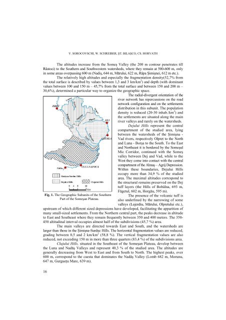
Dejului Hills represent the central<br />
compartment of the studied area, lying<br />
between the watersheds of the Şimişna -<br />
Vad rivers, respectively Olpret to the North<br />
and Luna - Borşa to the South. To the East<br />
and Northeast it is bordered by the Someşul<br />
Mic Corridor, continued with the Someş<br />
valley between Dej and Vad, while to the<br />
West they come into contact with the central<br />
compartment of the Almaş – Agrij Depression.<br />
Within these boundaries, Dejului Hills<br />
occupy more than 34,9 % of the studied<br />
area. The maximal altitudes correspond to<br />
the structural remains preserved on the Dej<br />
tuff layers (the Hills of Bobâlna, 693 m,<br />
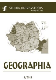
Fig. 1. The Geographic Subunits of the Southern<br />
Part of the Someşan Plateau.<br />
Făgetul, 602 m, Horgău, 595 m).<br />
The presence of the volcanic tuff is<br />
also underlined by the narrowing of some<br />
valleys (Lujerdiu, Mărului, Olpretului etc.),<br />
upstream of which different sized depressions have developed, facilitating the apparition of<br />
many small-sized settlements. From the Northern central part, the peaks decrease in altitude<br />
to East and Southeast where they remain frequently between 350 and 400 meters. The 350-<br />
450 altitudinal interval occupies almost half of the subdivisions (45,7 %) area.<br />
The main valleys are directed towards East and South, and the watersheds are<br />
larger than those in the Şimişna-Surduc Hills. The horizontal fragmentation values are reduced,<br />
grading between 0,5 and 2 km/km 2 (58,8 %). The vertical fragmentation values are also<br />
reduced, not exceeding 150 m in more than three quarters (83,4 %) of the subdivisions area.<br />
Clujului Hills, situated in the Southeast of the Someşan Plateau, develop between<br />
the Luna and Nadăş Valleys and represent 40,3 % of the studied area. The altitudes are<br />
generally decreasing from West to East and from South to North. The highest peaks, over<br />
600 m, correspond to the cuesta that dominates the Nadăş Valley (Lomb 682 m, Morunu,<br />
647 m, GurgueŃu Mare, 639 m).<br />
16