El Centro PF225 ESSR - CBP.gov
El Centro PF225 ESSR - CBP.gov
El Centro PF225 ESSR - CBP.gov

Create successful ePaper yourself
Turn your PDF publications into a flip-book with our unique Google optimized e-Paper software.
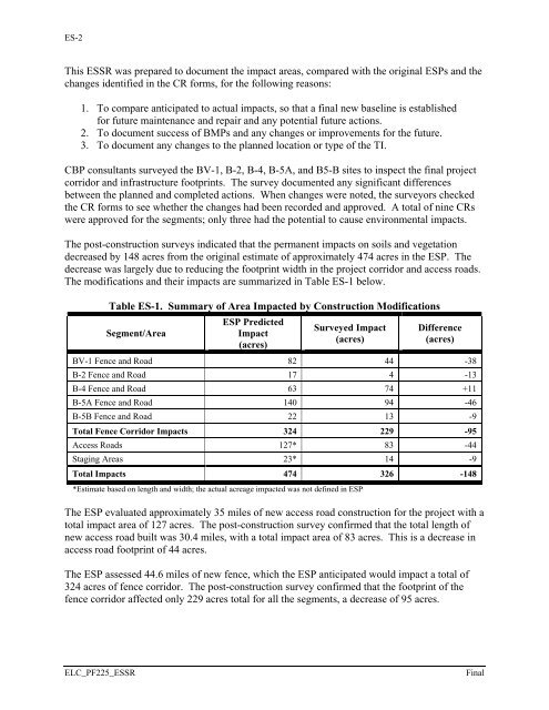
ES-2<br />
This <strong>ESSR</strong> was prepared to document the impact areas, compared with the original ESPs and the<br />
changes identified in the CR forms, for the following reasons:<br />
1. To compare anticipated to actual impacts, so that a final new baseline is established<br />
for future maintenance and repair and any potential future actions.<br />
2. To document success of BMPs and any changes or improvements for the future.<br />
3. To document any changes to the planned location or type of the TI.<br />
<strong>CBP</strong> consultants surveyed the BV-1, B-2, B-4, B-5A, and B5-B sites to inspect the final project<br />
corridor and infrastructure footprints. The survey documented any significant differences<br />
between the planned and completed actions. When changes were noted, the surveyors checked<br />
the CR forms to see whether the changes had been recorded and approved. A total of nine CRs<br />
were approved for the segments; only three had the potential to cause environmental impacts.<br />
The post-construction surveys indicated that the permanent impacts on soils and vegetation<br />
decreased by 148 acres from the original estimate of approximately 474 acres in the ESP. The<br />
decrease was largely due to reducing the footprint width in the project corridor and access roads.<br />
The modifications and their impacts are summarized in Table ES-1 below.<br />
Table ES-1. Summary of Area Impacted by Construction Modifications<br />
Segment/Area<br />
ESP Predicted<br />
Impact<br />
(acres)<br />
Surveyed Impact<br />
(acres)<br />
Difference<br />
(acres)<br />
BV-1 Fence and Road 82 44 -38<br />
B-2 Fence and Road 17 4 -13<br />
B-4 Fence and Road 63 74 +11<br />
B-5A Fence and Road 140 94 -46<br />
B-5B Fence and Road 22 13 -9<br />
Total Fence Corridor Impacts 324 229 -95<br />
Access Roads 127* 83 -44<br />
Staging Areas 23* 14 -9<br />
Total Impacts 474 326 -148<br />
*Estimate based on length and width; the actual acreage impacted was not defined in ESP<br />
The ESP evaluated approximately 35 miles of new access road construction for the project with a<br />
total impact area of 127 acres. The post-construction survey confirmed that the total length of<br />
new access road built was 30.4 miles, with a total impact area of 83 acres. This is a decrease in<br />
access road footprint of 44 acres.<br />
The ESP assessed 44.6 miles of new fence, which the ESP anticipated would impact a total of<br />
324 acres of fence corridor. The post-construction survey confirmed that the footprint of the<br />
fence corridor affected only 229 acres total for all the segments, a decrease of 95 acres.<br />
ELC_<strong>PF225</strong>_<strong>ESSR</strong><br />
Final