Features: - Tanker Operator
Features: - Tanker Operator
Features: - Tanker Operator

Create successful ePaper yourself
Turn your PDF publications into a flip-book with our unique Google optimized e-Paper software.
TECHNOLOGY - NAVAIDS<br />
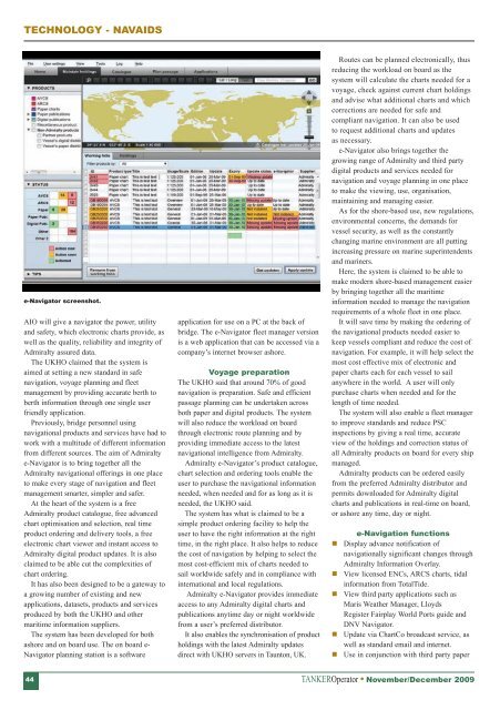
e-Navigator screenshot.<br />
AIO will give a navigator the power, utility<br />
and safety, which electronic charts provide, as<br />
well as the quality, reliability and integrity of<br />
Admiralty assured data.<br />
The UKHO claimed that the system is<br />
aimed at setting a new standard in safe<br />
navigation, voyage planning and fleet<br />
management by providing accurate berth to<br />
berth information through one single user<br />
friendly application.<br />
Previously, bridge personnel using<br />
navigational products and services have had to<br />
work with a multitude of different information<br />
from different sources. The aim of Admiralty<br />
e-Navigator is to bring together all the<br />
Admiralty navigational offerings in one place<br />
to make every stage of navigation and fleet<br />
management smarter, simpler and safer.<br />
At the heart of the system is a free<br />
Admiralty product catalogue, free advanced<br />
chart optimisation and selection, real time<br />
product ordering and delivery tools, a free<br />
electronic chart viewer and instant access to<br />
Admiralty digital product updates. It is also<br />
claimed to be able cut the complexities of<br />
chart ordering.<br />
It has also been designed to be a gateway to<br />
a growing number of existing and new<br />
applications, datasets, products and services<br />
produced by both the UKHO and other<br />
maritime information suppliers.<br />
The system has been developed for both<br />
ashore and on board use. The on board e-<br />
Navigator planning station is a software<br />
application for use on a PC at the back of<br />
bridge. The e-Navigator fleet manager version<br />
is a web application that can be accessed via a<br />
company’s internet browser ashore.<br />
Voyage preparation<br />
The UKHO said that around 70% of good<br />
navigation is preparation. Safe and efficient<br />
passage planning can be undertaken across<br />
both paper and digital products. The system<br />
will also reduce the workload on board<br />
through electronic route planning and by<br />
providing immediate access to the latest<br />
navigational intelligence from Admiralty.<br />
Admiralty e-Navigator’s product catalogue,<br />
chart selection and ordering tools enable the<br />
user to purchase the navigational information<br />
needed, when needed and for as long as it is<br />
needed, the UKHO said.<br />
The system has what is claimed to be a<br />
simple product ordering facility to help the<br />
user to have the right information at the right<br />
time, in the right place. It also helps to reduce<br />
the cost of navigation by helping to select the<br />
most cost-efficient mix of charts needed to<br />
sail worldwide safely and in compliance with<br />
international and local regulations.<br />
Admiralty e-Navigator provides immediate<br />
access to any Admiralty digital charts and<br />
publications anytime day or night worldwide<br />
from a user’s preferred distributor.<br />
It also enables the synchronisation of product<br />
holdings with the latest Admiralty updates<br />
direct with UKHO servers in Taunton, UK.<br />
Routes can be planned electronically, thus<br />
reducing the workload on board as the<br />
system will calculate the charts needed for a<br />
voyage, check against current chart holdings<br />
and advise what additional charts and which<br />
corrections are needed for safe and<br />
compliant navigation. It can also be used<br />
to request additional charts and updates<br />
as necessary.<br />
e-Navigator also brings together the<br />
growing range of Admiralty and third party<br />
digital products and services needed for<br />
navigation and voyage planning in one place<br />
to make the viewing, use, organisation,<br />
maintaining and managing easier.<br />
As for the shore-based use, new regulations,<br />
environmental concerns, the demands for<br />
vessel security, as well as the constantly<br />
changing marine environment are all putting<br />
increasing pressure on marine superintendents<br />
and mariners.<br />
Here, the system is claimed to be able to<br />
make modern shore-based management easier<br />
by bringing together all the maritime<br />
information needed to manage the navigation<br />
requirements of a whole fleet in one place.<br />
It will save time by making the ordering of<br />
the navigational products needed easier to<br />
keep vessels compliant and reduce the cost of<br />
navigation. For example, it will help select the<br />
most cost effective mix of electronic and<br />
paper charts each for each vessel to sail<br />
anywhere in the world. A user will only<br />
purchase charts when needed and for the<br />
length of time needed.<br />
The system will also enable a fleet manager<br />
to improve standards and reduce PSC<br />
inspections by giving a real time, accurate<br />
view of the holdings and correction status of<br />
all Admiralty products on board for every ship<br />
managed.<br />
Admiralty products can be ordered easily<br />
from the preferred Admiralty distributor and<br />
permits downloaded for Admiralty digital<br />
charts and publications in real-time on board,<br />
or ashore any time, day or night.<br />
e-Navigation functions<br />
Display advance notification of<br />
navigationally significant changes through<br />
Admiralty Information Overlay.<br />
View licensed ENCs, ARCS charts, tidal<br />
information from TotalTide.<br />
View third party applications such as<br />
Maris Weather Manager, Lloyds<br />
Register Fairplay World Ports guide and<br />
DNV Navigator.<br />
Update via ChartCo broadcast service, as<br />
well as standard email and internet.<br />
Use in conjunction with third party paper<br />
44<br />
TANKER<strong>Operator</strong> November/December 2009