A Review of Remote Sensing Application in Archaeological Research
A Review of Remote Sensing Application in Archaeological Research
A Review of Remote Sensing Application in Archaeological Research

You also want an ePaper? Increase the reach of your titles
YUMPU automatically turns print PDFs into web optimized ePapers that Google loves.
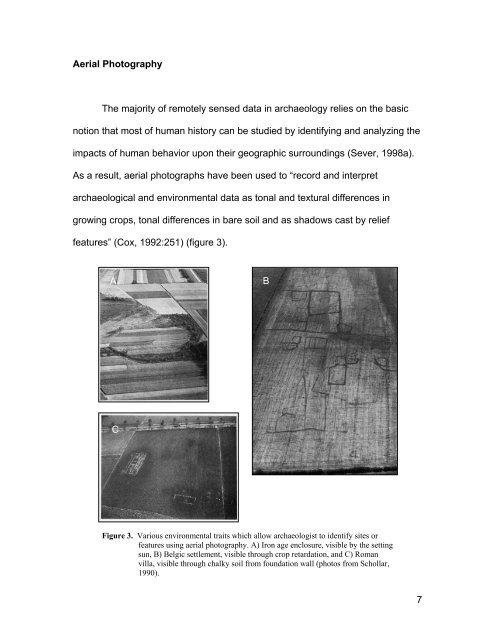
Aerial Photography<br />
The majority <strong>of</strong> remotely sensed data <strong>in</strong> archaeology relies on the basic<br />
notion that most <strong>of</strong> human history can be studied by identify<strong>in</strong>g and analyz<strong>in</strong>g the<br />
impacts <strong>of</strong> human behavior upon their geographic surround<strong>in</strong>gs (Sever, 1998a).<br />
As a result, aerial photographs have been used to “record and <strong>in</strong>terpret<br />
archaeological and environmental data as tonal and textural differences <strong>in</strong><br />
grow<strong>in</strong>g crops, tonal differences <strong>in</strong> bare soil and as shadows cast by relief<br />
features” (Cox, 1992:251) (figure 3).<br />
A<br />
B<br />
C<br />
Figure 3. Various environmental traits which allow archaeologist to identify sites or<br />
features us<strong>in</strong>g aerial photography. A) Iron age enclosure, visible by the sett<strong>in</strong>g<br />
sun, B) Belgic settlement, visible through crop retardation, and C) Roman<br />
villa, visible through chalky soil from foundation wall (photos from Schollar,<br />
1990).<br />
7