

Africa Water Atlas - UNEP/GRID-Sioux Falls
Africa Water Atlas - UNEP/GRID-Sioux Falls
Africa Water Atlas - UNEP/GRID-Sioux Falls

Create successful ePaper yourself
Turn your PDF publications into a flip-book with our unique Google optimized e-Paper software.
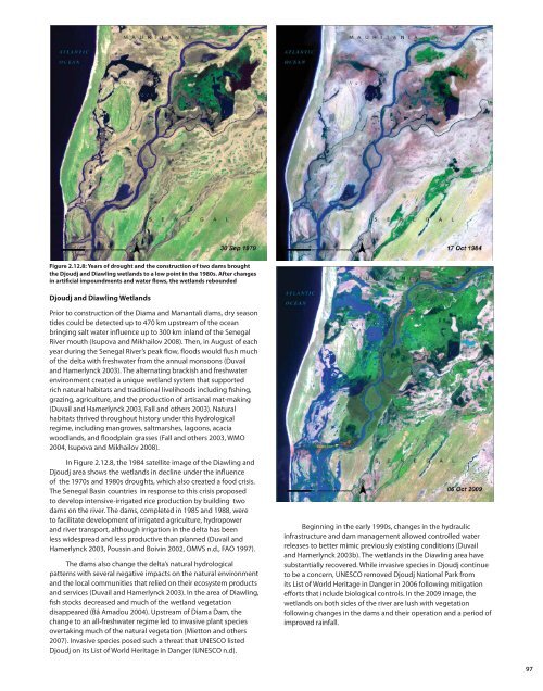
Figure 2.12.8: Years of drought and the construction of two dams brought<br />
the Djoudj and Diawling wetlands to a low point in the 1980s. After changes<br />
in artificial impoundments and water flows, the wetlands rebounded<br />
Djoudj and Diawling Wetlands<br />
Prior to construction of the Diama and Manantali dams, dry season<br />
tides could be detected up to 470 km upstream of the ocean<br />
bringing salt water influence up to 300 km inland of the Senegal<br />
River mouth (Isupova and Mikhailov 2008). Then, in August of each<br />
year during the Senegal River’s peak flow, floods would flush much<br />
of the delta with freshwater from the annual monsoons (Duvail<br />
and Hamerlynck 2003). The alternating brackish and freshwater<br />
environment created a unique wetland system that supported<br />
rich natural habitats and traditional livelihoods including fishing,<br />
grazing, agriculture, and the production of artisanal mat-making<br />
(Duvail and Hamerlynck 2003, Fall and others 2003). Natural<br />
habitats thrived throughout history under this hydrological<br />
regime, including mangroves, saltmarshes, lagoons, acacia<br />
woodlands, and floodplain grasses (Fall and others 2003, WMO<br />
2004, Isupova and Mikhailov 2008).<br />
In Figure 2.12.8, the 1984 satellite image of the Diawling and<br />
Djoudj area shows the wetlands in decline under the influence<br />
of the 1970s and 1980s droughts, which also created a food crisis.<br />
The Senegal Basin countries in response to this crisis proposed<br />
to develop intensive-irrigated rice production by building two<br />
dams on the river. The dams, completed in 1985 and 1988, were<br />
to facilitate development of irrigated agriculture, hydropower<br />
and river transport, although irrigation in the delta has been<br />
less widespread and less productive than planned (Duvail and<br />
Hamerlynck 2003, Poussin and Boivin 2002, OMVS n.d., FAO 1997).<br />
The dams also change the delta’s natural hydrological<br />
patterns with several negative impacts on the natural environment<br />
and the local communities that relied on their ecosystem products<br />
and services (Duvail and Hamerlynck 2003). In the area of Diawling,<br />
fish stocks decreased and much of the wetland vegetation<br />
disappeared (Bâ Amadou 2004). Upstream of Diama Dam, the<br />
change to an all-freshwater regime led to invasive plant species<br />
overtaking much of the natural vegetation (Mietton and others<br />
2007). Invasive species posed such a threat that UNESCO listed<br />
Djoudj on its List of World Heritage in Danger (UNESCO n.d).<br />
Beginning in the early 1990s, changes in the hydraulic<br />
infrastructure and dam management allowed controlled water<br />
releases to better mimic previously existing conditions (Duvail<br />
and Hamerlynck 2003b). The wetlands in the Diawling area have<br />
substantially recovered. While invasive species in Djoudj continue<br />
to be a concern, UNESCO removed Djoudj National Park from<br />
its List of World Heritage in Danger in 2006 following mitigation<br />
efforts that include biological controls. In the 2009 image, the<br />
wetlands on both sides of the river are lush with vegetation<br />
following changes in the dams and their operation and a period of<br />
improved rainfall.<br />
97


