

Africa Water Atlas - UNEP/GRID-Sioux Falls
Africa Water Atlas - UNEP/GRID-Sioux Falls
Africa Water Atlas - UNEP/GRID-Sioux Falls

Create successful ePaper yourself
Turn your PDF publications into a flip-book with our unique Google optimized e-Paper software.
conditions (Gossel and others 2004, CEDARE 2001,<br />
Ebraheem and others 2003). Experts generally<br />
accept that the system has not been in equilibrium<br />
for thousands of years and that groundwater levels<br />
were already declining well before artificial extraction<br />
began (Heinl and Brinkman 1989, Gossel and others<br />
2004). Thus, any water withdrawal from the aquifer<br />
under the current climate would be considered<br />
“water mining,” or a rate that exceeds recharge.<br />
Precipitation<br />
Figure 2.16.2: <strong>Water</strong> abstraction by population (Source:<br />
CEDARE 2001)<br />
of groundwater decline will significantly exceed<br />
historical rates (Ebraheem and others 2003).<br />
While it is clear that the aquifer system holds<br />
an enormous reserve of water, estimates vary<br />
considerably as to the amount—from as little as<br />
15 000 km 3 (Alker 2008) to 135 000 km 3 (Gossel and<br />
others 2004), to as much as 457 570 km 3 (Bakhbakhi<br />
2006). It is generally believed that the aquifer’s water<br />
dates from wetter climates in the past (5 000–10 000<br />
and 20 000–25 000 years BP) and that no significant<br />
recharge is taking place under current climate<br />
Arid and hyper-arid climate conditions in most of the<br />
region dramatically magnify the aquifer’s importance.<br />
Almost all of the water used by people living<br />
above the aquifer comes either from groundwater<br />
abstraction or diversion from the Nile. The average<br />
annual mean rainfall is less than 50 mm and on<br />
average vast areas over the aquifer system receive<br />
no measurable precipitation. The wettest area at the<br />
northernmost tip of Libya receives around 425 mm of<br />
rain. Northern Darfur in Sudan is the wettest area to<br />
the south but sees only an average of around 200 mm<br />
each year (Figure 2.16.4).<br />
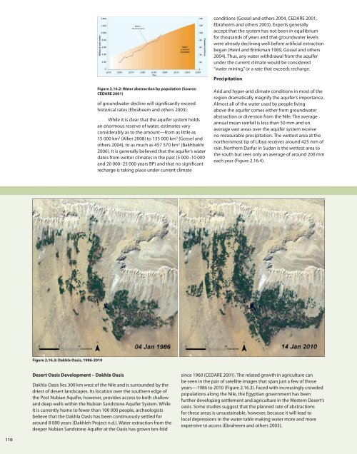
Figure 2.16.3: Dakhla Oasis, 1986-2010<br />
Desert Oasis Development – Dakhla Oasis<br />
Dakhla Oasis lies 300 km west of the Nile and is surrounded by the<br />
driest of desert landscapes. Its location over the southern edge of<br />
the Post Nubian Aquifer, however, provides access to both shallow<br />
and deep wells within the Nubian Sandstone Aquifer System. While<br />
it is currently home to fewer than 100 000 people, archeologists<br />
believe that the Dakhla Oasis has been continuously settled for<br />
around 8 000 years (Dakhleh Project n.d.). <strong>Water</strong> extraction from the<br />
deeper Nubian Sandstone Aquifer at the Oasis has grown ten-fold<br />
since 1960 (CEDARE 2001). The related growth in agriculture can<br />
be seen in the pair of satellite images that span just a few of those<br />
years—1986 to 2010 (Figure 2.16.3). Faced with increasingly crowded<br />
populations along the Nile, the Egyptian government has been<br />
further developing settlement and agriculture in the Western Desert’s<br />
oasis. Some studies suggest that the planned rate of abstractions<br />
for these areas is unsustainable, however, because it will lead to<br />
local depressions in the water table making water more and more<br />
expensive to access (Ebraheem and others 2003).<br />
110


