XTreme EFIS - MGL Avionics
XTreme EFIS - MGL Avionics
XTreme EFIS - MGL Avionics

Create successful ePaper yourself
Turn your PDF publications into a flip-book with our unique Google optimized e-Paper software.
<strong>XTreme</strong> Operating Manual Page 6<br />
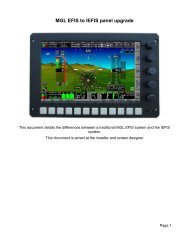
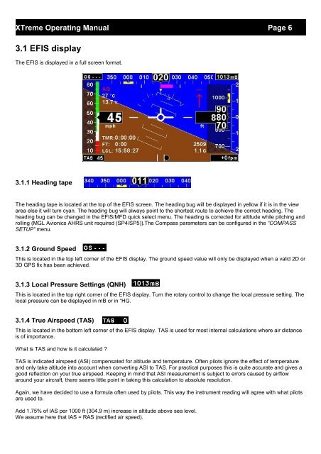
3.1 <strong>EFIS</strong> display<br />
The <strong>EFIS</strong> is displayed in a full screen format.<br />
3.1.1 Heading tape<br />
The heading tape is located at the top of the <strong>EFIS</strong> screen. The heading bug will be displayed in yellow if it is in the view<br />
area else it will turn cyan. The heading bug will always point to the shortest route to achieve the correct heading. The<br />
heading bug can be changed in the <strong>EFIS</strong>/MFD quick select menu. The heading is corrected for attitude while pitching and<br />
rolling (<strong>MGL</strong> <strong>Avionics</strong> AHRS unit required (SP4/SP5)).The Compass parameters can be configured in the “COMPASS<br />
SETUP” menu.<br />
3.1.2 Ground Speed<br />
This is located in the top left corner of the <strong>EFIS</strong> display. The ground speed value will only be displayed when a valid 2D or<br />
3D GPS fix has been achieved.<br />
3.1.3 Local Pressure Settings (QNH)<br />
This is located in the top right corner of the <strong>EFIS</strong> display. Turn the rotary control to change the local pressure setting. The<br />
local pressure can be displayed in mB or in “HG.<br />
3.1.4 True Airspeed (TAS)<br />
This is located in the bottom left corner of the <strong>EFIS</strong> display. TAS is used for most internal calculations where air distance<br />
is of importance.<br />
What is TAS and how is it calculated ?<br />
TAS is indicated airspeed (ASI) compensated for altitude and temperature. Often pilots ignore the effect of temperature<br />
and only take altitude into account when converting ASI to TAS. For practical purposes this is quite accurate and gives a<br />
good reflection on your true airspeed. Keeping in mind that ASI measurement is subject to errors caused by airflow<br />
around your aircraft, there seems little point in taking this calculation to absolute resolution.<br />
Again, we have decided to use a formula often used by pilots. This way the instrument reading will agree with what pilots<br />
are used to.<br />
Add 1.75% of IAS per 1000 ft (304.9 m) increase in altitude above sea level.<br />
We assume here that IAS = RAS (rectified air speed).