View the Wisconsin Biking Guide - Wisconsin Department of Tourism
View the Wisconsin Biking Guide - Wisconsin Department of Tourism
View the Wisconsin Biking Guide - Wisconsin Department of Tourism

You also want an ePaper? Increase the reach of your titles
YUMPU automatically turns print PDFs into web optimized ePapers that Google loves.
RD<br />
MC CORD RD<br />
CLOVER<br />
VALLEY RD<br />
TAYLOR RD<br />
ENGEL RD<br />
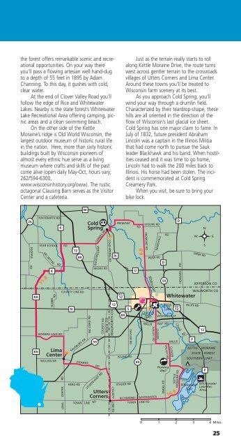
<strong>the</strong> forest <strong>of</strong>fers remarkable scenic and recreational<br />
opportunities. On your way <strong>the</strong>re<br />
you’ll pass a flowing artesian well hand-dug<br />
to a depth <strong>of</strong> 55 feet in 1895 by Adam<br />
Channing. To this day, it gushes with cold,<br />
clear water.<br />
At <strong>the</strong> end <strong>of</strong> Clover Valley Road you’ll<br />
follow <strong>the</strong> edge <strong>of</strong> Rice and Whitewater<br />
Lakes. Nearby is <strong>the</strong> state forest’s Whitewater<br />
Lake Recreational Area <strong>of</strong>fering camping, picnic<br />
areas and a clean swimming beach.<br />
On <strong>the</strong> o<strong>the</strong>r side <strong>of</strong> <strong>the</strong> Kettle<br />
Moraine’s ridge is Old World <strong>Wisconsin</strong>, <strong>the</strong><br />
largest outdoor museum <strong>of</strong> historic rural life<br />
in <strong>the</strong> nation. Here, more than sixty historic<br />
buildings built by <strong>Wisconsin</strong> pioneers <strong>of</strong><br />
almost every ethnic hue serve as a living<br />
museum where crafts and skills <strong>of</strong> <strong>the</strong> past<br />
come alive (open daily May-Oct, hours vary;<br />
262/594-6300,<br />
www.wisconsinhistory.org/oww). The rustic<br />
octagonal Clausing Barn serves as <strong>the</strong> Visitor<br />
Center and a cafeteria.<br />
Just as <strong>the</strong> terrain really starts to roll<br />
along Kettle Moraine Drive, <strong>the</strong> route turns<br />
west across gentler terrain to <strong>the</strong> crossroads<br />
villages <strong>of</strong> Utters Corners and Lima Center.<br />
Around <strong>the</strong>se towns you’ll be treated to<br />
<strong>Wisconsin</strong> farm scenery at its best.<br />
As you approach Cold Spring, you’ll<br />
wind your way through a drumlin field.<br />
Characterized by <strong>the</strong>ir teardrop-shape, <strong>the</strong>se<br />
hills are all oriented in <strong>the</strong> direction <strong>of</strong> <strong>the</strong><br />
flow <strong>of</strong> <strong>Wisconsin</strong>’s last glacial ice sheet.<br />
Cold Spring has one major claim to fame. In<br />
July <strong>of</strong> 1832, future president Abraham<br />
Lincoln was a captain in <strong>the</strong> Illinois Militia<br />
that had come north to pursue <strong>the</strong> Sauk<br />
leader Blackhawk and his band. When hostilities<br />
ceased and it was time to go home,<br />
Lincoln had to walk <strong>the</strong> 200 miles back to<br />
Illinois. His horse had been stolen. The incident<br />
is commemorated at Cold Spring<br />
Creamery Park.<br />
When you visit, be sure to bring your<br />
bike lock.<br />
M<br />
26<br />
PEOPPLE<br />
HACKBARTH RD<br />
STAR SCHOOL RD<br />
MC INTYRE<br />
K<br />
K<br />
RD<br />
12<br />
89<br />
Cold<br />
Spring<br />
BUCKING HAM<br />
CARNES RD<br />
MESKE RD<br />
COLD SPRING RD<br />
N<br />
FREMONT<br />
RD<br />
6.8<br />
STOUPE RD<br />
FREMONT RD<br />
MARSHALL<br />
PIPER RD<br />
D<br />
U<br />
RD<br />
D<br />
PIPER RD<br />
HOWARD RD<br />
11.8<br />
Whitewater<br />
59<br />
JEFFERSON CO<br />
KK<br />
KK<br />
HOBBS<br />
RD<br />
BOWERS LAKE RD<br />
Lima<br />
Center<br />
WILLOW DR<br />
COUNTY LINE RD<br />
N<br />
SALISBURY DR<br />
BERG RD<br />
PIONEER<br />
TOWN LINE<br />
59<br />
RD<br />
COUNTY RD<br />
STURTEVANT RD<br />
Utters<br />
Corners<br />
RD<br />
12<br />
ROCK CO<br />
WALWORTH CO<br />
BUS<br />
12<br />
S<br />
89<br />
ISLAND RD<br />
STADER RD<br />
89<br />
Cravath<br />
Lake<br />
WILLIS<br />
RICHMOND- WHITEWATER<br />
TOWN LINE RD<br />
RAY RD<br />
VALLEY RD<br />
Flowing<br />
Well<br />
Whitewater<br />
Tripp<br />
Lake<br />
WISCONSIN ST<br />
MILLIS<br />
CLOVER<br />
KETTLE<br />
MORAINE RD<br />
14.9<br />
BUS<br />
12<br />
Creek<br />
RD<br />
BLUFF RD<br />
P<br />
WALWORTH CO<br />
12<br />
KETTLE MORAINE<br />
STATE FOREST<br />
SOUTHERN UNIT<br />
Whitewater<br />
Lake<br />
P<br />
Whitewater<br />
Lake Rec.<br />
Area<br />
LIMA CENTER RD<br />
COUNTY LINE RD<br />
0 1 2 3 4 Miles<br />
25